Location: 5 miles (8 km) South of New Kingston
Fort Charles
Open: 9am-4:45pm
Closed Good Friday & Christmas Day
Off
Elizabeth Ave
876-967-8438
Constructed: 1650-1660
Port Royal is a colonial town situated 5 miles (8 km) South of New Kingston in Jamaica. It is famous for its British Fort Charles that was constructed in 1650- 60 to protect colonies against many pirates that were common in the area. Port Royal ("Puerto Real" in Spanish) was the seat of the British government in Jamaica and the main fishing and commercial base of the island during the seventeenth century. In its heyday it also welcomed a large number of pirates who under the protection of the British attacked the Spanish and French ships. It was destroyed by a large earthquake, tsunami and sinking due to the sand on the ground on June 7, 1692, during which two-thirds of the city sank in the waters of the Caribbean Sea. After this disaster, the commercial activity of the island moved to the city of Kingston, current capital of Jamaica.
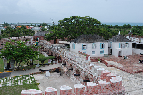
Fort Charles
Fort Charles stands as Port Royal’s most iconic
landmark, a star-shaped fortress at the western edge of the town
overlooking the harbor entrance. Built in 1656 under British Governor
Edward D’Oyley, it was the first of six forts constructed to defend the
port and remains the best-preserved today. Named after King Charles II,
its stone and coral walls, originally mounting 36 cannons, were designed
to repel Spanish and pirate attacks. The fort’s history includes a stint
under Admiral Horatio Nelson in 1779, who paced its ramparts as a young
lieutenant, a legacy marked by a plaque near the central courtyard.
Visitors can explore its weathered battlements, where a dozen
restored cannons—some originals from the 1600s—point seaward, offering
panoramic views of Kingston Harbour and the Blue Mountains. The Fort
Charles Maritime Museum, housed in the former officers’ quarters,
displays artifacts like cannonballs, ship models, and Nelson-era relics,
alongside exhibits on Port Royal’s pirate past. Open daily from 9 a.m.
to 5 p.m. (subject to staffing), admission is typically $10 USD, with
guided tours available sporadically. The fort’s sturdy walls, softened
by time and hurricanes, evoke its role as a sentinel of a bygone era,
despite damage from the 1692 earthquake and later storms.
The
Giddy House
The Giddy House, a quirky relic near Fort Charles, is a
tilted artillery storehouse that sank partially into the ground during
the 1880 earthquake, leaving it at a 45-degree angle. Built in the
1860s, this small brick building once stored cannonballs and gunpowder
but now offers a disorienting experience—visitors feel dizzy stepping
inside due to its slant, earning its playful name. A cannon outside,
also half-submerged from the quake, adds to the surreal scene.
Accessible via a short walk from the fort, it’s free to enter and
photograph, a whimsical reminder of Port Royal’s seismic vulnerability
and a favorite for Instagram snaps.
St. Peter’s Church
St.
Peter’s Church, a modest Anglican structure on Church Street, is one of
Port Royal’s oldest surviving buildings, dating to 1725–1726. Replacing
an earlier church destroyed in the 1692 earthquake, its red-brick facade
and simple gabled design reflect British colonial architecture, with a
small steeple added later. Inside, wooden pews and stained-glass windows
create a peaceful ambiance, while the churchyard holds weathered
tombstones, including that of Lewis Galdy, a merchant who survived being
swallowed and spat out by the 1692 quake—a tale etched in local lore.
The silver communion plate, a gift from Henry Morgan in 1671, is a
prized artifact, though often stored for safekeeping. Open for Sunday
services at 10 a.m., it welcomes visitors weekdays by request, offering
a quiet glimpse into the town’s post-disaster resilience.
The
Sunken City (Underwater Archaeological Site)
The Sunken City of Port
Royal, submerged beneath Kingston Harbour since the 1692 earthquake, is
a world-renowned archaeological marvel, often called the “Pompeii of the
Caribbean.” When the quake liquefied the sandy spit, 33 acres (13
hectares) of the town—two-thirds of its original footprint—sank into
4–40 feet (1.2–12 meters) of water, preserving streets, homes, and
wharves in a time capsule. Excavations since the 1950s by figures like
Edwin Link and Robert Marx have unearthed artifacts—pewter tankards,
clay pipes, Spanish coins, and even a pocket watch stopped at 11:43
a.m., the quake’s moment—now housed in Kingston’s National Museum and
Port Royal’s museum.
Accessible only by boat and scuba diving,
the site requires a permit from the Jamaica National Heritage Trust
(JNHT), with guided tours offered by operators like Port Royal Divers
($50–$100 USD, depending on equipment). Visibility varies (10–30 feet),
but divers can explore submerged walls, hearths, and shipwrecks,
including Morgan’s vessel Satisfaction. Its tentative UNESCO World
Heritage status underscores its global significance, though it remains a
niche sight due to its underwater nature and preservation needs.
Fisherman’s Beach and Local Waterfront
Fisherman’s Beach, a narrow
strip along the West Harbour near the town center, is Port Royal’s
living pulse, where colorful wooden fishing boats bob alongside
weathered piers. Local fishermen mend nets and haul in snapper, lobster,
and kingfish, offering a taste of the town’s modern livelihood. The
beach lacks the powdery sands of tourist hotspots but exudes
authenticity, with vendors selling fresh catch or fried fish with bammy
(cassava flatbread) from shacks like Gloria’s, a local institution famed
for its seafood platters ($10–$15 USD). The waterfront extends to the
Old Naval Dockyard, now a quiet relic with crumbling piers and rusted
anchors, once bustling with British warships. It’s a casual spot to
watch the sunset over Navy Island, a short boat ride away.
Lime
Cay
Lime Cay, a tiny uninhabited islet 15 minutes offshore by boat
from Port Royal, is a pristine escape within Kingston Harbour. Reachable
via fisherman boats or tour operators ($20–$30 USD round-trip), this
sandy speck—barely 1,000 feet (300 meters) long—offers crystal-clear
waters ideal for swimming, snorkeling, and picnicking. Its shallow reefs
teem with parrotfish and sergeant majors, while its seclusion draws
locals on weekends for barbecues and relaxation. Named for its
historical lime kilns, it’s a natural counterpoint to Port Royal’s
historical weight, with no facilities beyond what visitors bring,
enhancing its wild appeal.
Folly Ruins (Nearby)
Though
technically just outside Port Royal on the mainland near Kingston, the
Folly Ruins are often linked to the town’s tourist circuit, a 10-minute
drive or ferry ride away. This crumbling Roman-style mansion, built in
1905 by American millionaire Alfred Mitchell, once boasted marble floors
and a private zoo before abandonment in the 1930s. Overgrown with vines
and partially collapsed, it’s a haunting sight, free to explore with a
taxi drop-off ($10 USD from Port Royal). Its eerie beauty and harbor
views make it a compelling detour, tied to the region’s history of
fleeting opulence.
Before European arrival, the area that would become
Port Royal was inhabited by the Taíno (Arawak) people, who lived across
Jamaica, including the fertile Liguanea Plain near modern Kingston. The
Palisadoes spit, then a series of cays and shoals, offered little arable
land but served as a fishing ground and navigational marker for Taíno
canoes. Archaeological evidence, such as shell middens, suggests
seasonal use rather than permanent settlement. Christopher Columbus
landed on Jamaica in 1494 during his second voyage, naming the island
“Santiago,” though he did not establish a foothold at Port Royal. The
Spanish colonized Jamaica in 1509, focusing on settlements like Sevilla
la Nueva and Villa de la Vega (Spanish Town), leaving the spit largely
undeveloped due to its vulnerability to storms and lack of freshwater.
Spanish rule lasted until 1655, when an English expedition under
Admiral William Penn and General Robert Venables captured Jamaica as
part of Oliver Cromwell’s Western Design to disrupt Spanish dominance in
the Caribbean. The English initially used the Palisadoes—then called
“Cayo de Carena” (Careening Cay)—as a careening site to repair ships,
renaming it “Point Cagway” or “The Point.” Its strategic position at the
mouth of the harbor, one of the world’s finest natural ports, made it an
ideal defensive outpost, prompting the construction of rudimentary
fortifications.
Port Royal’s ascent began in earnest after 1655, as
the English transformed it from a minor outpost into a thriving port.
Governor Edward D’Oyley, appointed in 1661, invited
privateers—essentially state-sanctioned pirates—to use Port Royal as a
base to attack Spanish shipping, offering letters of marque in exchange
for a share of the plunder. This policy, continued under Governor Thomas
Modyford from 1664, turned the town into a pirate haven, attracting
notorious figures like Henry Morgan, Christopher Myngs, and Roche
Brasiliano. By 1662, Fort Charles was built on the western tip of the
spit, its cannons guarding the harbor entrance, followed by five
additional forts—James, Carlisle, Rupert, Morgan, and Walker—forming a
defensive ring.
The late 17th century marked Port Royal’s golden
age. Fueled by pirate loot, trade in enslaved Africans, and commerce
from sugar plantations, it grew into a bustling port of 6,500 residents
by 1692, surpassing Boston and rivaling London in wealth. With 2,000
buildings—taverns, brothels, warehouses, and grand homes—crammed into 51
acres (20 hectares), it earned its “wicked” reputation for debauchery,
gambling, and excess. Merchants thrived on goods like gold, silver, rum,
and spices, while the town’s wharves saw 20–40 ships daily. Morgan,
knighted and appointed lieutenant governor in 1674 after sacking Panama,
epitomized this era, though his death in 1688 signaled a shift as
England curbed privateering under the 1670 Treaty of Madrid.
Port Royal’s prosperity ended abruptly on June 7,
1692, when a massive earthquake struck at 11:43 a.m. Measuring an
estimated 7.5 magnitude, it liquefied the sandy spit—built on unstable
sediment—causing two-thirds of the town (33 acres) to slide into the
harbor. Over 2,000 died instantly as buildings sank, and a tsunami swept
away survivors, with total deaths reaching 5,000 from ensuing disease
and chaos. The disaster, described by survivors like rector Emmanuel
Heath as divine retribution for the town’s sins, left only Fort Charles
and a few structures standing, submerging wharves, homes, and graves now
preserved underwater as an archaeological marvel.
The English
attempted to rebuild on the remaining land, but fires in 1703 and
hurricanes in 1712, 1722, and 1726 thwarted recovery. Survivors
relocated to the mainland, founding Kingston in 1692, which eclipsed
Port Royal as Jamaica’s commercial hub by 1703. The British Navy
maintained a presence, commissioning a naval station at Port Royal in
1728 under Commodore Edward St. Lo, with barracks and a hospital built
by 1735. It served as a key base during the 18th century, notably under
Admiral George Rodney, who fortified it against French threats in the
1770s. Yet, its civilian prominence faded, reduced to a military outpost
and fishing village.
The 19th century saw Port Royal as a fortified naval
hub, peaking during the Napoleonic Wars when it hosted the Royal Navy’s
Jamaica Station. Admiral Horatio Nelson briefly commanded Fort Charles
in 1779, cementing its military lore. The abolition of slavery in 1834
and the decline of sugar shifted economic focus inland, while steamships
diminished the need for a wind-dependent harbor. Hurricanes in 1842,
1850, and 1874 further battered the town, and by 1905, the naval base’s
strategic value waned with the rise of larger ports like Kingston. The
British abandoned it as a major station in 1905, leaving a skeleton crew
until World War II, when it briefly housed U.S. and British forces
guarding the Panama Canal approach.
A devastating earthquake in
1907, killing 800 across Jamaica, damaged remaining structures, and
subsequent storms—1944, 1951 (Hurricane Charlie)—eroded the spit
further. By the mid-20th century, Port Royal was a shadow of its former
self, its population dwindling to a few hundred fishermen and naval
personnel, its once-grand buildings reduced to ruins or modest homes.
The 20th century marked a shift toward preservation
and tourism. In 1962, Jamaica’s independence spurred interest in Port
Royal’s history, with excavations beginning in 1951 under Edwin Link and
intensifying in the 1960s under Robert Marx and the Institute of
Jamaica. The sunken city—33 acres underwater at depths of 4–40 feet
(1.2–12 meters)—yielded artifacts like pewter plates, clay pipes, and
Spanish coins, earning UNESCO tentative World Heritage status in 1999 as
a “Disaster Archaeology” site. Fort Charles, restored in the 1970s,
became a museum, while the Giddy House—a tilted artillery store from the
1880 quake—added quirky charm.
Tourism grew modestly, with
attractions like the Port Royal Archaeological and Historical Museum
(opened 1977) and boat tours to Lime Cay drawing visitors. Hollywood
spotlighted it in Pirates of the Caribbean (2003), boosting its pirate
mystique. Yet, hurricanes—Ivan (2004), Dean (2007), and Sandy
(2012)—continued to threaten, with Sandy flooding the spit and prompting
resilience projects. By 2025, plans for a $60 million cruise pier and
heritage revitalization, backed by the Jamaica National Heritage Trust,
aim to revive its economy, though progress remains slow amid funding and
environmental challenges.
Port Royal lies at the western end of the Palisadoes,
a slender barrier of sand and gravel that forms the southern boundary of
Kingston Harbour, separating it from the open Caribbean Sea. The spit
connects to the mainland at Harbour View, about 8 miles (13 kilometers)
east of Kingston’s city center, placing Port Royal roughly 10 miles (16
kilometers) southeast of Jamaica’s capital. Portland Bight, a large bay
to the southwest, and the Hellshire Hills, a limestone upland rising to
1,000 feet (305 meters), frame its western horizon, while the Blue
Mountains loom to the north, with peaks like Blue Mountain Peak (7,402
feet/2,256 meters) visible on clear days, about 25 miles (40 kilometers)
away.
The town’s strategic position at the harbor’s
entrance—guarding a 10-square-mile (26-square-kilometer) basin with
depths up to 60 feet (18 meters)—made it a vital maritime hub
historically, controlling access to Kingston and the Liguanea Plain. Its
isolation from inland Jamaica, accessible only by the winding Palisadoes
Road or boat, has preserved its distinct character, distancing it from
Kingston’s urban sprawl.
Port Royal occupies a flat, low-lying spit, averaging
just 3–10 feet (1–3 meters) above sea level, with its highest natural
point barely exceeding 15 feet (4.5 meters). The Palisadoes itself is a
dynamic tombolo, formed over millennia by longshore drift depositing
sand and coral debris between a series of cays, later stabilized by
mangroves and human engineering. The spit’s width varies from 200 to
1,000 feet (60 to 305 meters), narrowing at points like Plumb Point,
where storms have historically breached it, and widening at Port Royal,
where the town’s 51 acres (20 hectares) once supported a dense colonial
settlement.
The town’s terrain is predominantly sandy, with a
thin layer of sediment overlaying limestone bedrock—a geology that
proved catastrophic during the 1692 earthquake, when liquefaction sank
two-thirds of the original town into the harbor. Today, the remaining
land is a compact grid, hemmed by the sea on three sides—west, south,
and east—with Fort Charles marking its western tip. The harbor shore to
the north is gentler, with shallow beaches and remnants of old wharves,
while the Caribbean side features rocky edges and narrow strips of sand,
eroded by centuries of waves and storms.
Port Royal’s geography is defined by its intimate
relationship with water, surrounded by Kingston Harbour to the north and
the Caribbean Sea to the south:
Kingston Harbour: This vast natural
harbor, stretching 7 miles (11 kilometers) east-west and 2 miles (3.2
kilometers) north-south, is sheltered by the Palisadoes and fed by
rivers like the Rio Cobre and Hope River. Its deep waters—averaging
40–60 feet (12–18 meters)—and calm conditions made it a prized anchorage
for pirate ships and British frigates, with Port Royal guarding its
narrow, 1,000-foot-wide (305-meter) entrance.
Caribbean Sea: South of
the spit, the open sea laps against rocky shores and small beaches, with
depths dropping sharply beyond the fringing reef to over 1,000 feet (305
meters) within a mile. The reef, though diminished by storms and
pollution, once teemed with coral and fish, protecting the town from
wave action.
Tidal Creeks and Lagoons: Small brackish creeks, like
those near Norman Manley International Airport 5 miles (8 kilometers)
east, punctuate the spit, remnants of its cay origins, though most are
now silted or drained.
The Sunken City, submerged since the 1692
earthquake, lies just offshore in the harbor, its 33 acres (13 hectares)
preserved at depths of 4–40 feet (1.2–12 meters). This underwater
landscape—streets, walls, and wharves—adds a haunting dimension to Port
Royal’s geography, accessible only by diving.
Port Royal shares Jamaica’s tropical wet-and-dry
climate (Köppen Aw), moderated by its coastal position and trade winds:
Temperature: Averages 80–86°F (27–30°C) year-round, with highs
occasionally reaching 92°F (33°C) in summer (June–August) and lows
dipping to 72°F (22°C) in winter (December–February). Sea breezes temper
the heat, though humidity hovers at 75–85%.
Rainfall: Annual
precipitation totals 35–40 inches (890–1,020 millimeters), with a wet
season (May–November) peaking in October (6–8 inches/150–200 mm monthly)
and a dry season (December–April) averaging 1–2 inches (25–50 mm).
Hurricanes, like Ivan (2004) and Sandy (2012), bring heavy rain and
storm surges, flooding the low spit.
Winds: Northeast trade winds
blow steadily at 10–20 mph (16–32 kph), cooling the town but exposing
its southern shore to erosion.
Its low elevation and exposure
make Port Royal vulnerable to sea-level rise and storm surges, a growing
concern as climate change intensifies.
Port Royal’s natural vegetation has been heavily
altered by human settlement, but remnants of its coastal ecology
persist:
Mangroves: Red and black mangroves (Rhizophora mangle and
Avicennia germinans) fringe the harbor shore and eastern spit,
stabilizing sediment and nurturing juvenile fish, crabs, and wading
birds like herons. Hurricane damage has thinned these stands, though
restoration efforts continue.
Coastal Scrub: Sea grapes, coconut
palms, and grasses dot the sandy southern edge, adapted to salt spray
and poor soil, with wild cotton and lignum vitae scattered inland.
Marine Life: The harbor and fringing reef support snapper, lobster, and
kingfish—vital to local fishermen—while the sunken city’s artificial
reef harbors parrotfish and barracuda, drawing divers.
The town’s
small size limits terrestrial wildlife to urban-adapted
species—mongooses, lizards, and gulls—though migratory birds like
frigatebirds soar overhead. The harbor’s pollution from Kingston runoff
has degraded water quality, but its marine ecosystem remains a draw for
eco-tourism.
Port Royal’s layout reflects its colonial grid,
compacted into a 0.2-square-mile (0.5-square-kilometer) area after the
1692 quake reduced its original 51 acres. Streets like Queen’s Street
and Church Street form a tight network, lined with modest homes, fish
shacks, and historic ruins—Fort Charles, St. Peter’s Church, and the
Giddy House. The Errol Flynn Marina, a modern addition near the West
Harbour, offers docks for yachts and small cruise ships, boosting
tourism potential.
The Palisadoes Road (A1), a narrow, two-lane
causeway, is the sole land link to Kingston, winding past Norman Manley
International Airport and prone to flooding during storms. No bridges
span the harbor to the mainland, reinforcing Port Royal’s isolation—a
boat ride from Kingston’s waterfront (15–20 minutes, $5–$10 USD) is an
alternative. The town’s low elevation and lack of high ground amplify
its vulnerability, with concrete sea walls and sandbags offering limited
protection against surges.
Port Royal’s culture is deeply rooted in its
tumultuous history. Before European contact, the area was frequented by
the Taíno (Arawak) people, whose fishing practices along the Palisadoes
left traces in local lore, though their presence was light due to the
spit’s sparse resources. The Spanish arrival in 1494 introduced the
first European influence, but it was the British capture of Jamaica in
1655 that transformed Port Royal into a cultural crucible. From the
1660s to 1692, it thrived as a pirate haven under governors like Edward
D’Oyley and Thomas Modyford, attracting a motley crew of
privateers—Henry Morgan among them—whose exploits of plunder, rum, and
revelry earned it the moniker “the wickedest city.” This era of excess,
fueled by loot from Spanish galleons and the slave trade, infused Port
Royal with a rebellious, freewheeling spirit that lingers in its
storytelling and pride.
The 1692 earthquake, which sank
two-thirds of the town, marked a cultural pivot, shifting it from a den
of vice to a British naval base by the 18th century. The Royal Navy’s
presence—epitomized by Fort Charles and figures like Horatio
Nelson—introduced a layer of military discipline and British customs,
from Anglican worship to naval traditions. After the naval decline in
the early 20th century, Port Royal settled into its current role as a
fishing village, with African-descended residents—many tracing lineage
to enslaved workers—shaping its modern identity through resilience and
adaptation.
Port Royal’s lingua franca is Jamaican Patois, a
Creole blend of English and West African languages like Akan and Igbo,
spoken with a rhythmic lilt that echoes across the waterfront. Phrases
like “Yuh haffi tek time” (You have to take it slow) or “Port Royal a di
real vibe” reflect its laid-back yet proud character. Standard English
surfaces in formal settings—church services or museum tours—but Patois
dominates daily life, from fishermen haggling over catch to children
playing near the Giddy House. The town’s pirate past infuses its speech
with nautical flair—“ship ahoy” or “landlubber”—while stories of
Morgan’s raids and the quake’s wrath are passed down orally, often with
a mix of awe and humor.
Storytelling is a cultural cornerstone,
with tales like that of Lewis Galdy—who survived being swallowed and
spat out by the 1692 earthquake—told at gatherings or over rum at local
bars. These narratives, blending history with myth, keep Port Royal’s
wild legacy alive, a tradition rooted in African griot practices adapted
to a Caribbean context.
Music in Port Royal resonates with Jamaica’s broader
soundscape, though its small size limits formal venues. Reggae, born in
nearby Kingston, drifts across the harbor, with Bob Marley’s anthems
like “Redemption Song” a staple at fisherman shacks or weekend lime
sessions. The town’s maritime roots favor sea shanties and folk tunes,
sung by older residents with lyrics about lost ships or pirate gold,
echoing its naval and buccaneer past. Quelbe, a folk genre with banjo,
gourd, and flute, occasionally surfaces, linking Port Royal to broader
Crucian traditions.
Dance is less formalized but
spontaneous—fishermen might sway to a reggae beat while mending nets, or
children mimic the “bruk out” moves of dancehall, a Kingston export.
Community events, like fish fries or heritage days, spark impromptu
dancing, with Patois chants and laughter weaving through the rhythm, a
testament to the town’s communal joy.
Port Royal’s food culture is a seafood lover’s
delight, anchored by its fishing heritage. Fried fish with bammy—snapper
or kingfish battered with cornmeal, served with cassava flatbread—is a
daily staple, sold at shacks like Gloria’s ($10–$15 USD), a local
institution famed for its fish soup spiced with Scotch bonnet peppers
and thyme. Jerk fish, a twist on the Portland-born classic, uses pimento
wood to smoke catch fresh from the harbor, blending African and Taíno
cooking methods. Conch stew, rich with coconut milk and yam, nods to the
town’s coastal bounty, while festival (fried cornmeal dumplings) and
escovitch fish—vinegar-marinated with onions and peppers—round out the
menu.
Rum, a legacy of the pirate days, flows freely—Wray &
Nephew overproof is a favorite, sipped neat or in “boom,” a potent punch
with fruit juice. Markets offer mangoes, coconuts, and breadfruit,
roasted or boiled as a hearty side, reflecting the town’s
self-sufficiency. Meals are communal, often shared on Fisherman’s Beach,
with fishermen swapping tales over plates, a tradition of camaraderie
that binds the community.
Port Royal’s traditions center on its maritime and
historical identity. Fish fries, held weekly or spontaneously, are
cultural touchstones—grills smoke with fresh catch, reggae plays, and
locals and visitors mingle under the stars. The Port Royal Seafood
Festival, an annual event in October (dates vary), celebrates this
heritage with cooking contests, live music, and boat races, drawing
modest crowds from Kingston. Heritage Day, tied to Jamaica’s
independence celebrations in August, features tours of Fort Charles and
storytelling at St. Peter’s Church, honoring the town’s past.
Religious life, rooted in British influence, revolves around St. Peter’s
Church, where Sunday services blend Anglican hymns with Patois prayers,
attended by a tight-knit congregation. Funerals and weddings often spill
into communal feasts, with rum and fish sustaining the mood. The town’s
pirate lore inspires informal “buccaneer nights” at bars, where locals
dress in eye patches and recount Morgan’s exploits, a playful nod to its
wicked reputation.
Port Royal’s culture thrives on its small, close-knit
community, where most residents know each other by name or
nickname—“Fish Man” or “Rasta Joe.” Fishing dominates daily life, with
men heading out at dawn in wooden boats, returning to mend nets on
Fisherman’s Beach, while women often sell the catch or run food stalls.
This interdependence fosters a strong sense of unity, tempered by a
pride in surviving centuries of storms and quakes—residents boast of
their “Port Royal toughness.”
The town’s isolation—connected only
by the Palisadoes Road or boat—reinforces its distinct identity, setting
it apart from Kingston’s urban pulse. While poverty lingers (median
income around $15,000–$20,000 JMD monthly/$96–$128 USD), ingenuity
shines through in boat repairs, fish trade, and tourism hustles—guides
offering sunken city dives or fort tours. Rastafarianism has a quiet
presence, with some fishermen sporting dreadlocks and sharing Ital
recipes, though Christianity, via St. Peter’s, remains dominant.