Location: Saba, Leeward Islands Map
Area: 5 sq mi (13 sq km)
Saba Marine National Park encompasses the waters and sea surrounding
the Caribbean island of Saba, a territory of the Kingdom of the
Netherlands, from the highest point of 200 feet (60 meters) deep. In
total, the marine park covers approximately 5 square miles (13
square kilometers). At the time of its creation in 1987, the
government passed the Marine Environment Ordinance to protect the
coral reefs and other marine life within the park. The Saba
Conservation Foundation manages the Marine National Park, as well as
the island's hyperbaric facility and natural sites on land.
A
number of regulations attempt to ensure that the park's aquatic life
remains healthy. The area is divided into zones according to
acceptable uses. Commercial fishing is prohibited in certain
locations to prevent overfishing. The reefs are protected from
damage by 36 permanently moored buoys where boats can moor. Divers
are not permitted to dive on their own; must dive with guides from
one of Saba's three dive shops.
The Saba National Marine Park consists of the waters around Saba from
the high water mark to a depth of 60 meters. This results in a total
area of about 1300 hectares.
The national park is divided into
four designated zones, which differ according to the intended use. About
a third of the park area is primarily designated as a diving area. The
park contains some unusual rock formations of interest to divers,
including the well-known The Pinnacles and Diamond Rock. The so-called
Pinnacles are a volcanic structure that extends from a depth of about
100 meters to 27 meters below the water surface and is covered with
colorful corals. The Diamond Rock is a rock off the west coast of Saba
that has a similar structure to the Pinnacles, but breaks the water
surface. The part that protrudes from the water is covered with a layer
of guano and looks like it is covered with snow from a distance.
Near Ladder Bay there is a labyrinth of trenches and ledges created by
lava. Just west of Fort Bay harbor is the so-called Tent Reef. This is
an unusual geological structure in the form of a wide rocky ledge that
lies just four meters below sea level near the coast, but drops steeply
towards the northwest.
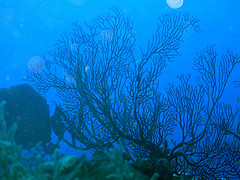
The waters of the national park offer various habitats with a high
level of biodiversity. Of particular note here are Saba's coral reefs,
which are formed by corals of the genera Montastraea, Agaricia,
Colpophyllia and Diploria, among others, of which the Montastraea
species are the most numerous. The reefs are home to countless species
of fish, including sablefish, triggerfish, parrotfish, scorpionfish and
moray eels. In addition to corals and fish, large numbers of
invertebrates such as sponges, sea urchins, crabs and anemones live
here.
Another significant habitat is the seagrass beds found in
some places on the seabed, which are mainly formed by the species
Thalassia testudinum and Syringodium filiforme as well as kelp-forming
green algae of the genus Halimeda. The seagrass beds are important for
many fish to lay their eggs and raise their young.
Sharks can
often be seen in the more open waters. The most common species are the
Caribbean reef shark, the Atlantic nurse shark and the lesser blacktip
shark. Hammerhead sharks and manta rays are also occasionally seen.
Sightings of whale sharks and migrating humpback whales have also been
reported.
The Saba National Marine Park is also home to two
endangered species of sea turtle: the hawksbill turtle and the green sea
turtle.
The national park has been a popular destination for diving tourists
since the 1980s, mainly because of its coral reefs. Around 20,000 dives
are recorded every year. The water off the island is pleasantly warm
(usually between 26° and 28°C) and clear. The minimum underwater
visibility is given as 20 meters. Ecotourism now plays an important role
in Saba's economy.
The waters around Saba are also regularly
visited by cruise ships. For smaller ships, especially yachts, a network
of buoys has been installed to which the ships can moor without having
to drop anchor. This is done to protect the coral reefs and seagrass
meadows from damage.
The administration of the national park is the responsibility of the
Saba Conservation Foundation (SCF for short), a non-governmental
organization founded in 1987 and based in Fort Bay. Under the
administration of the SCF, the Saba National Marine Park is one of the
few financially self-sustaining marine parks in the world, financed by
entrance fees, souvenir sales and donations. Access to the park is free
for Saba residents, while divers and other tourists have to pay a fee.
The park administration provides two decompression chambers that can
be used in the event of diving accidents.