Location: 25 mi (40 km) Southeast of San Juan Map
Tel. 787 888 1810
Open: 7:30am- 6pm daily
Area: 28,000 acres (115 km2)
El Yunque National Forest, officially named Caribbean National Forest, is Puerto Rico’s crown jewel of natural heritage and the only tropical rainforest in the U.S. National Forest System. Located in the northeastern part of the island, primarily in the municipalities of Río Grande, Naguabo, and Luquillo, it spans 28,434 acres (11,505 hectares) across the rugged Sierra de Luquillo mountains. Known as El Yunque (from the Taíno word Yuké, meaning “white land,” possibly referring to its misty peaks), the forest is a biodiversity hotspot, home to cascading waterfalls, endemic species, and panoramic vistas. Its lush greenery, frequent rains, and cultural resonance make it a magnet for over 600,000 visitors annually, from hikers to scientists to spiritual seekers.
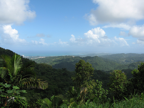
El Yunque’s geography is defined by its mountainous
terrain, tropical climate, and hydrological richness, shaped by millions
of years of geological activity.
Topography: The forest occupies
the Sierra de Luquillo, a range formed 40 million years ago by tectonic
uplift and volcanic activity. Elevations range from 100 feet (30 meters)
at the base to 3,543 feet (1,080 meters) at El Toro, the highest peak.
Other notable summits include El Yunque Peak (3,465 feet/1,056 meters)
and Pico del Este (3,441 feet/1,049 meters). Steep slopes, narrow
valleys, and rocky outcrops create a dramatic landscape, with trails
winding through dense forest to open ridges.
Climate: As
a tropical rainforest, El Yunque receives 120–240 inches (3,000–6,000
mm) of rain annually, varying by elevation. Temperatures average 70–80°F
(21–27°C), with high humidity (80–100%). The forest experiences four
microclimates: tabonuco forest (below 2,000 feet), palo colorado forest
(2,000–2,500 feet), sierra palm forest (2,500–3,000 feet), and dwarf or
cloud forest (above 3,000 feet), where fog and stunted trees dominate.
Rainfall feeds streams and waterfalls, making El Yunque a vital
watershed.
Water Features: The forest is crisscrossed by rivers—Río
Mameyes, Río Fajardo, Río Espiritu Santo—that carve gorges and feed
iconic waterfalls. La Coca Falls (85 feet/26 meters) greets visitors at
PR-191’s entrance, while La Mina Falls (35 feet/11 meters), accessible
via a scenic trail, is a popular swimming spot. Smaller cascades, like
Juan Diego Falls, offer hidden gems. These waters flow to coastal
aquifers, supplying nearby communities.
Geology: El Yunque’s bedrock
includes volcanic rocks (andesite, basalt) and intrusive igneous
formations, overlaid by clay-rich soils. Erosion has sculpted its
karst-like features—sinkholes, cliffs—though it’s less pronounced than
Puerto Rico’s northwest karst zone (e.g., Río Camuy). Landslides,
triggered by hurricanes, reshape trails and riverbeds periodically.
El Yunque is a global biodiversity hotspot, hosting
species found nowhere else and playing a critical role in regional
ecology.
Flora: The forest supports over 240 tree species, 23 of
which are endemic. Tabonuco trees (Dacryodes excelsa) dominate lower
elevations, their buttressed roots anchoring steep slopes. Higher up,
sierra palms (Prestoea montana) form dense stands, while ausubo
(Manilkara bidentata) and orchids thrive in mid-levels. The cloud
forest’s stunted trees, draped in epiphytes and mosses, adapt to
constant mist. Exotic species, like bamboo, were introduced
post-plantation eras but are managed to protect natives.
Fauna: El
Yunque is famed for the Puerto Rican parrot (Amazona vittata), or
iguaca, an endangered endemic with vibrant green feathers and a red
forehead; fewer than 600 remain in the wild. The coquí frog
(Eleutherodactylus coqui), Puerto Rico’s unofficial mascot, fills the
air with its “co-kee” call, joined by 12 other endemic frog species.
Reptiles include the Puerto Rican boa and anole lizards, while
invertebrates—snails, spiders, walking sticks—abound. Birds like the
Puerto Rican tody (Todus mexicanus) and bananaquit add color. Mammals
are limited, with bats (e.g., Artibeus jamaicensis) and introduced
mongooses most common.
Conservation: Designated a forest reserve in
1876 by Spanish King Alfonso XII, El Yunque became a U.S. National
Forest in 1903. It’s part of UNESCO’s Man and the Biosphere Programme,
reflecting its global ecological value. Threats include invasive species
(e.g., mongooses preying on parrots), climate change (altering
rainfall), and hurricane damage. The U.S. Forest Service runs recovery
programs, like parrot breeding at the Iguaca Aviary, and monitors trails
to curb erosion.
Ecosystem Services: El Yunque’s watershed supplies
20% of Puerto Rico’s drinking water, feeding reservoirs like Carraízo.
Its carbon sequestration helps mitigate climate change, while its trails
support eco-tourism, generating millions for the economy.
El Yunque’s history blends natural evolution with human
interaction, from indigenous reverence to colonial exploitation and
modern stewardship.
Taíno Heritage: The Taíno, Puerto Rico’s
pre-Columbian people, revered El Yunque as a sacred site, believing
its peaks housed the deity Yúcahu, god of fertility and agriculture.
Petroglyphs and ceremonial sites, like those near Río Blanco,
suggest ritual use. The forest’s rivers and caves were likely
sources of food and refuge.
Spanish Colonial Era (1508–1898):
Spanish settlers logged tabonuco and ausubo for shipbuilding and
furniture, clearing lower slopes for coffee and sugarcane
plantations. In 1876, Spain declared El Yunque a Crown Reserve to
curb deforestation, one of the earliest conservation acts in the
Americas. Trails like El Yunque Trail trace paths used by jíbaros
(rural farmers).
U.S. Administration (1898–Present): After the
Spanish-American War, the U.S. designated El Yunque a national
forest, naming it Luquillo Forest Reserve (later Caribbean National
Forest). The Civilian Conservation Corps (CCC) in the 1930s built
roads, trails, and stone structures, like the Baño Grande pool,
still visible today. Scientific research began in the 20th century,
with El Yunque hosting long-term ecological studies via the Luquillo
Experimental Forest.
Hurricanes and Recovery: Hurricanes—San
Felipe (1928), Hugo (1989), María (2017), Fiona (2022)—have reshaped
El Yunque, toppling trees and flooding trails. María’s 155-mph winds
stripped 30% of the canopy, but regrowth by 2025 shows resilience.
Post-María closures (2017–2019) spurred infrastructure upgrades,
though Fiona’s floods caused temporary setbacks.
El Yunque is a cultural touchstone for Puerto Ricans and a global
symbol of tropical wilderness.
Puerto Rican Identity: The forest
embodies the island’s jíbaro spirit—resilient, rooted in nature. Its
coquí frog and lush greenery appear in art, music (e.g., salsa lyrics),
and folklore, like tales of the chupacabra or forest spirits. For
locals, visiting El Yunque is a rite of passage, akin to a pilgrimage.
Taíno Legacy: The forest’s spiritual aura persists, with some Puerto
Ricans honoring Taíno traditions through ceremonies or eco-activism. Its
name, tied to Yúcahu, evokes pre-colonial pride, amplified by nearby
Taíno sites like Caguana.
Global Appeal: As a U.S. National Forest,
El Yunque draws international visitors, featured in travel shows (Planet
Earth, Lonely Planet) and films for its cinematic beauty. Its research
role—studying climate change, biodiversity—elevates its scientific
stature, with data shared globally.
Tourism Impact: El Yunque
generates jobs for guides, vendors, and hotels in Río Grande and
Luquillo. Its proximity to San Juan (25 miles/40 km) makes it a day-trip
staple, though locals lament overcrowding, prompting visitor caps
post-2020.
El Yunque offers a range of experiences, from easy walks to
challenging hikes, though reservations are now required due to
post-hurricane management.
Access: Located at PR-191, Km 4.2, Río
Grande, the forest is a 45-minute drive from San Juan via PR-3 and
PR-66. Public transport (públicos) is scarce, so renting a car or
booking a tour is ideal. Parking fees are $2–5. Since 2020, free online
reservations via recreation.gov are mandatory for the main PR-191
corridor (book 30 days in advance; 50% same-day slots open at 8 a.m.).
Visitor Centers: The El Portal Visitor Center (rebuilt post-María,
reopened 2020) offers exhibits on ecology, a film, a gift shop, and a
café. Rangers provide maps and safety tips. Smaller info stations, like
Angelito Trailhead, serve secondary entrances.
Trails:
La Mina
Trail (0.7 miles/1.1 km, moderate): Leads to La Mina Falls, where
visitors swim in a natural pool. Steep steps and slippery rocks require
sturdy shoes. Reopened in 2023 after repairs.
El Yunque Trail (2.5
miles/4 km, strenuous): Climbs to El Yunque Peak, offering 360° views of
the Atlantic and Caribbean. Cloud forest sections are misty, with
orchids and coquí calls.
Angelito Trail (0.4 miles/0.6 km, easy):
Ends at Las Damas Pool on the Río Mameyes, ideal for families. Less
crowded than PR-191.
El Toro Trail (4 miles/6.4 km, difficult): A
rugged trek to El Toro Peak, through dense jungle. Requires permits and
stamina.
Waterfalls and Lookouts: Beyond La Mina, La Coca and
Juan Diego Falls are photo favorites. Yokahú Tower (69 feet/21 meters),
a CCC-built stone lookout, offers views to Luquillo’s beaches. Mt.
Britton Tower (3,087 feet/941 meters) rewards hikers with sweeping
vistas, often above the clouds.
Activities: Swimming is allowed at La
Mina and Las Damas (no lifeguards; check flash flood warnings).
Birdwatching, photography, and guided eco-tours are popular. Camping is
prohibited, but picnic areas at Baño Grande and Palma Vista accommodate
groups. Night tours, focusing on coquí and bioluminescence, require
special permits.
Preparation: Bring water, snacks, rain gear, and
insect repellent (mosquitoes thrive post-rain). Trails are muddy; hiking
boots trump sneakers. Cell service is spotty, so download maps. Flash
floods close trails, so check fs.usda.gov/elyunque or call (787)
888-1880 for alerts.
Hours and Costs: Open 7:30 a.m.–5 p.m. daily,
though trails close earlier in bad weather. Entry is free, but El Portal
costs $8 (adults), $4 (kids 3–15). Guided tours from San Juan ($75–150)
include transport and fees.
El
Yunque faces environmental and logistical hurdles, intensified by its
popularity and climate.
Hurricane Recovery: María’s 2017
devastation—80% tree loss in some areas—required $40 million in repairs
(FEMA-funded). Trails like La Mina were rebuilt with sturdier bridges,
but Fiona (2022) caused mudslides, closing secondary paths. Full
recovery is projected by 2030, with reforestation ongoing.
Overcrowding: Pre-María, 1 million visitors strained trails and parking.
The reservation system caps PR-191 at 500 vehicles daily, but illegal
parking on backroads persists. Rangers enforce limits, fining violators
($50–100).
Invasive Species: Mongooses and feral cats threaten
parrots and frogs. Control programs trap invaders, while native
plantings (e.g., tabonuco saplings) restore habitats.
Climate Change:
Warmer temperatures and erratic rains disrupt coquí breeding and dry
streams. The Forest Service monitors via 100+ research plots, sharing
data with NASA and universities.
Community Ties: Locals push for
co-management to prioritize Puerto Rican voices, citing the U.S. Forest
Service’s mainland focus. Initiatives like Para La Naturaleza train
youth as guides, fostering ownership.
If your interest stems from Northern Ireland’s
geography, El Yunque contrasts sharply with Ulster’s forests:
Climate
and Flora: El Yunque’s tropical rainforest, with palms and epiphytes,
differs from the temperate oak and pine of Tollymore Forest Park (Down)
or Glenariff Forest (Antrim). Northern Ireland’s forests get 40–60
inches of rain annually, far less than El Yunque’s 200.
Scale: El
Yunque’s 28,434 acres dwarf Tollymore’s 1,600, but Northern Ireland’s
forests offer denser trail networks due to flatter terrain.
Wildlife:
El Yunque’s endemic frogs and parrots contrast with Ulster’s red
squirrels and buzzards. Both face invasive species (mongooses vs. grey
squirrels).
Cultural Role: El Yunque’s Taíno spirituality parallels
Celtic myths in Glenariff, but Puerto Rico’s colonial history adds a
Caribbean layer absent in Ulster.
If you’d prefer a focus on Northern
Irish forests, I can detail Tollymore, Glenariff, or others.
El Yunque is a pillar of Puerto Rico’s
identity and economy:
Symbolism: It represents Puerto Rican
resilience, regrowing after hurricanes like a metaphor for the island’s
recovery. Songs like “Preciosa” by Rafael Hernández invoke its beauty,
while artists paint its waterfalls.
Economic Boost: Tourism supports
1,000+ jobs in Río Grande, from food trucks selling pinchos to hotels
like the St. Regis Bahia. Day-trippers spend $50–100 locally, per
studies.
Global Reach: El Yunque’s UNESCO status and research role
draw scientists from Oxford to MIT. Its Instagram fame (#ElYunque) fuels
Puerto Rico’s brand, rivaling Old San Juan.
Local Life: Residents
hike for recreation or gather herbs (e.g., sarsaparilla) with permits.
Community festivals, like Luquillo’s Fiesta del Plátano, tie the forest
to jíbaro traditions.
To maximize a visit:
Book Early: Reserve PR-191 access at recreation.gov (free) or risk
missing out. El Portal tickets ($8) are separate; buy on-site or via
tours.
Timing: Arrive by 8 a.m. to beat crowds and heat. Afternoon
rains (1–3 p.m.) make trails slick, so morning hikes are best.
Gear:
Pack hiking boots, a poncho, sunscreen, and binoculars for birding.
Trails lack restrooms; use El Portal’s facilities.
Nearby: Pair El
Yunque with Luquillo Beach (10 miles away) for kioskos serving
alcapurrias, or visit Fajardo’s bioluminescent bay (20 miles) for a
night tour.
Safety: Heed flash flood warnings (posted at trailheads).
Stick to marked paths; off-trail hiking risks fines ($250) and injury.
Solo hikers should notify rangers.