Saint John or Saint John is an island that
constitutes with those of Saint Thomas and Saint Croix the Virgin
Islands of the United States, archipelago part of the West Indies.
It is also one of the three districts of the United States Virgin
Islands.
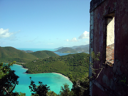
Saint John, with an area of 51 km2, had 4,170
inhabitants in 2010 (down from the 2000 census) and has the port of
Cruz Bay as its main town.
Set in a tropical forest setting,
it is 60% protected (about 30 km2) thanks to the Virgin Islands
National Park. A privileged treatment that we owe to the American
billionaire Laurance Spelman Rockefeller. In 1954, this
philanthropist was seduced by the beauty of the island where nature
had regained its rights after the end of slavery and the abandonment
of plantations by the Danes in the nineteenth century. He bought
more than 2,000 hectares of land, which he soon ceded to the United
States. It is up to the federal government to preserve them. This
was done in 1956 with the creation of the national park. Since then,
the latter has expanded considerably. Today, it preserves 5,650
hectares of land (beaches, mangroves, tropical rainforests...) and
2,286 hectares of coral reefs. Almost a million tourists visit this
sanctuary every year populated by 140 species of exotic birds.
The Reef Bay Hike is a hiking trail that leads, through the
tropical forest and endemic palm trees, to petroglyphs attributed to
the Taino Indians who arrived from Puerto Rico around 200 BC. The
Dennis Bay Historical District is an old sugar plantation protected
within the park.
Saint John was originally inhabited by Taíno natives,
but the island was conquered by the Caribs in the 14th century. In 1493,
the island was discovered by Christopher Columbus, but was not
colonized.
In 1680, the first Danish settlers arrived on the
island. In 1684, the island was claimed by the Danish West India and
Guinea company as Sankt Jan, but the United Kingdom also claimed the
island, and the settlers were retrieved.
In 1718, 20 Danish
planters founded the site of Coral Bay where a small fort was built. In
1728 there were about 100 plantations growing sugar cane, cotton and
tobacco. Slaves were brought from Africa to work on the plantations.
In 1733, a slave revolt led by the Akwamu began. A small group had
entered the fort with knives hidden in branch forests and had managed to
capture the fort. The uprising lasted seven months, and cost the lives
of a quarter of the population. With the help of French troops from
Martinique, the Danes managed to suppress the rebellion. The last Akwamu
committed suicide as French troops approached.
In 1762, the
British claim to Saint John was abandoned. A fort and settlement was
built at Cruz Bay in 1764. In 1848, slavery was abolished and the
Plantations fell into disrepair. Between 1850 and 1870, nearly half of
the population of Saint John Island left, and the economy began to
consist primarily of subsistence agriculture and fishing.
In
1917, Saint John was sold to the United States. In 1927, residents
received American citizenship. In 1952, Laurance Rockefeller purchased
the former Caneel Bay Plantation, and built a tourist resort. By 1956,
more land had been purchased by Rockefeller, and he, along with other
large landowners, decided to set aside an area of about 20 km2 for the
creation of the Virgin Islands National Park. In the second half of the
20th century, Saint John began to develop as a tourist island.
Several plantation ruins are located on Saint John.
Annaberg was one of the largest sugar cane plantations with factory and
Mill. There is a large plantation at Cinnamon Bay dating from the 18th
century. Near Cinnamon Bay and Reef Bay are indigenous petroglyphs
dating between 600 and 1500 CE.
On The Hill near Coral Bay is the
ruin of Fortsberg, the first fort on the island.
Saint John has
at its disposal many beaches including:
Cinnamon Bay Beach
Gibney
and Oppenheimer Beach
Honeymoon Beach
Salomon Beach
Trunk Bay
Saint John is 4 km east of Saint Thomas. The island is
of volcanic origin, having formed about 100 million years ago. Puerto
Rico, Saint John, Saint Thomas, and the British Virgin Islands with the
exception of Anegada together form the Puerto Rico Bank. In the
Pleistocene, it was one island, but due to the rise of the sea, Puerto
Rico and the Virgin Islands are separated by a 60-kilometer-wide sea
that is up to 30 meters deep.
The volcanoes that formed Saint
John are no longer active, but north of the island lies the convergent
plate boundary between the Caribbean and North American plates. The
collision between the two plates causes earthquakes and tsunamis in the
area.
Around Saint John are several small islands and rocky
points. Flanagan island is located in the extreme southeast of Saint
John. Denmark and the United Kingdom had decided that the border between
both Virgin Islands was halfway between Saint John and Peter Island,
however the uninhabited Flanagan Island was located between the two
islands. The border dispute continued after the sale of Saint John to
the United States. In 1977, the United Kingdom renounced its claim,
becoming a part of the U.S. Virgin Islands.
There is no airport on the island. The nearest airport is Cyril E. King Airport in Saint Thomas. At the Port of Cruz Bay, ferries depart to Saint Thomas, and to Jost Van Dyke and Tortola in the British Virgin Islands.
Many Zeeland and West Flemish settlers settled on Saint John, resulting in the development of the Creole language Negerhollands. In 1898, Alice Stevens was born on Saint John, and spoke Negerhollands as her mother tongue. In 1977, Stevens was one of the six last known speakers, eventually becoming the last speaker. In 1987, Stevens died and the language officially died out.