Location: Mal Pais, Puntarenas province Map
Area: 3,140 acres (12.7 km2) on land
4,420 acres (17.9 km2) of sea
Cabo Blanco Absolute Natural Reserve (Reserva Natural Absoluta Cabo Blanco), located at the southern tip of the Nicoya Peninsula in Puntarenas Province, Costa Rica, is a historic and ecologically significant protected area. Established on October 21, 1963, it holds the distinction of being Costa Rica’s first protected reserve, marking the genesis of the country’s renowned national park system. Covering 1,270 hectares (3,140 acres) of terrestrial land and 1,790 hectares (4,420 acres) of marine territory, the reserve protects a diverse mix of tropical moist forest, dry forest, pristine beaches, and marine ecosystems. Named after the guano-covered Cabo Blanco Island 1.6 km offshore, the reserve is a testament to Costa Rica’s conservation ethos, initiated by Swedish conservationist Nils Olof (Nicolás) Wessberg and his Danish wife, Karen Mogensen.
Cabo Blanco Absolute Natural Reserve is situated at the southernmost
point of the Nicoya Peninsula, at coordinates approximately 9°33′N,
85°06′W, within the Tempisque Conservation Area (ACT) of the National
System of Conservation Areas (SINAC). The reserve is accessible via the
small town of Cabuya, south of Montezuma (8 km) and east of Mal País and
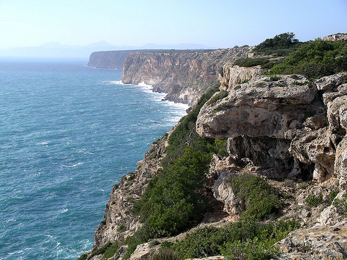
Santa Teresa (20–25 km). It faces the Pacific Ocean, with its rugged
coastline and Playa Cabo Blanco, a pristine white-sand beach, framed by
cliffs and rocky headlands.
Geographical Features
Terrestrial
Area: The reserve spans 1,270 hectares of mixed forest, including
primary forest at higher elevations and secondary forest (60–70 years
old) regenerating from past deforestation. Elevations range from sea
level to 5–300 meters, with the highest point at Cerro Altiliano.
Marine Area: The 1,790-hectare marine zone includes Cabo Blanco Island,
a seabird sanctuary, and coastal waters rich in marine life. The
island’s white cliffs, encrusted with guano, give the reserve its name
(“White Cape”).
Beaches: Playa Cabo Blanco, a half-moon bay, is
accessible only by hiking, offering seclusion and turquoise waters.
Playa Cuevas, a smaller beach with sea caves on the Mal País side, is
restricted to coastal access without trails.
Rivers and Mangroves:
Small rivers and mangrove patches support diverse ecosystems, with
riverbanks providing habitats for crabs and fish.
Climate: The
reserve has a tropical climate with:
Dry Season (December–April):
Sunny, with highs of 29–30°C (84–86°F) and lows of 20–21°C (68–70°F).
Ideal for hiking and beach visits due to clear skies and minimal rain.
Wet Season (May–November): Frequent, heavy afternoon showers, with
similar temperatures but higher humidity. Trails become muddy and
slippery, but forests are lush and wildlife active.
Geological
Context: The Nicoya Peninsula is part of the Nicoya Complex, a
geological formation of volcanic and sedimentary rock from the
Cretaceous period. The reserve’s rocky cliffs and sandy beaches result
from tectonic uplift and marine erosion, with Cabo Blanco Island serving
as a navigational landmark since the Spanish colonial era.
Cabo Blanco Absolute Natural Reserve is a biodiversity hotspot,
protecting a unique blend of moist tropical forest, dry tropical forest,
and marine ecosystems. Its establishment halted deforestation that had
reduced the peninsula’s forests by the 1960s, preserving a critical
refuge for species and regenerating secondary forests. The reserve’s San
Miguel Biological Station supports research, education, and
conservation, with facilities including classrooms, laboratories, and a
reference library.
Flora
The reserve hosts approximately 150
tree species, reflecting its transitional ecology:
Evergreen
Species: Dominant in moist forest areas, including Madroño (Lance Wood),
Guácimo (Bastard Cedar), Jobo (Hog Plum), Indio Desnudo (Gumbo Limbo),
and Guarumo (Cecropia).
Deciduous Species: Common in dry forest
zones, such as Pochote (Spiny Cedar), reaching over 40 meters, and Ceiba
(Silk Cotton Tree), towering up to 60 meters.
Rare Species: The
Camibar, found only in Cabo Blanco on the Nicoya Peninsula, highlights
the reserve’s unique botanical diversity.
Other Vegetation: Espavel
(Wild Cashew), Bull’s horn acacia (symbiotic with ants), and sparse
epiphytes due to limited water in dry forests. Toxic Manzanillo trees
(Hippomane mancinella) on beaches pose risks with irritant sap and
fruit.
Fauna
The reserve is home to a rich array of wildlife,
with 119 plant and animal species documented:
Mammals:
White-faced capuchin, howler monkey, white-tailed deer, agouti,
armadillo, anteater, paca, coati, raccoon, squirrel, sloth, coyote,
porcupine, kinkajou, and peccary. Large felids include jaguarundi,
margay, ocelot, and possibly puma, though sightings are rare due to
their elusive nature.
Birds: A haven for ornithologists, with species
like brown pelican, brown booby (Costa Rica’s largest colony),
magnificent frigatebird, laughing gull, common tern, osprey, scarlet
macaw, crested caracara, magpie-jay, long-tailed manakin, elegant
trogon, and sandpiper. Cabo Blanco Island is a critical seabird
sanctuary.
Reptiles: Black and green iguanas, whip-tailed lizards,
boa constrictors, and other snakes inhabit forests and beaches.
Marine Life: Coastal waters host orcas, humpback whales (seasonal),
dolphins, fish (e.g., snappers, groupers), crabs, mollusks, and coral
communities. A hawksbill turtle was recently spotted off Playa Cabo
Blanco.
Invertebrates: Thousands of red and purple land crabs scuttle
across the forest floor, creating a distinctive sound and defensive
behavior. Butterflies, bats, and Pseudomyrmex ants (symbiotic with
acacia trees) are abundant.
Conservation Efforts and Challenges
Historical Impact: By the 1950s, government policies incentivized
deforestation for agriculture, reducing the peninsula’s forests to a
small primary patch in Cabo Blanco. Wessberg and Mogensen’s purchase of
1,250 hectares in 1963, with international support, halted this
destruction, setting a precedent for Costa Rica’s 28% protected land
today.
Regeneration: The reserve’s secondary forests, now 60–70 years
old, demonstrate successful regeneration, with fish populations
recovering in marine zones.
Visitor Limits: Only 40 visitors per day
are allowed to minimize ecological impact, enforced by rangers.
San
Miguel Biological Station: Facilitates research on tropical ecosystems,
supporting global conservation efforts.
Challenges: Illegal logging,
fishing, and past hunting (e.g., jaguars nearly extirpated) threaten
biodiversity. Limited ranger presence and remote access complicate
enforcement. Climate change may alter rainfall, affecting dry forest
species.
Legacy: The reserve inspired the Karen Mogensen Nature
Reserve (near Montezuma) and Corcovado National Park, though Wessberg’s
assassination in 1975 on the Osa Peninsula underscored conservation’s
risks.
Cabo Blanco Absolute Natural Reserve is a cornerstone of Costa Rica’s
conservation history, embodying the nation’s “Pura Vida” ethos of living
in harmony with nature.
Historical Context
Origins: In the
1950s, the Nicoya Peninsula faced rampant deforestation as the
government rewarded land clearing with ownership. By 1960, only a small
primary forest remained in Cabo Blanco.
Wessberg and Mogensen:
Swedish immigrant Nils Olof Wessberg (Olaf or Nicolás) and Danish wife
Karen Mogensen arrived in 1955, settling near Montezuma. Inspired by
Cabo Blanco’s biodiversity during a seed-collecting trip, they rallied
international conservation groups (e.g., Sierra Club, World Wildlife
Fund) to purchase 1,250 hectares. On October 21, 1963, the Costa Rican
government declared it the Reserva Natural Absoluta Cabo Blanco, the
first protected area in Central America. Initially, access was
restricted to scientists, earning the “Absoluta” designation.
Legacy:
The reserve catalyzed Costa Rica’s national park system, now covering
25% of the country. Wessberg’s murder in 1975 while advocating for
Corcovado National Park galvanized further conservation efforts. The
Sendero Sueco (Swedish Trail) and Sendero Danes (Danish Trail) honor the
couple’s contributions.
Cultural Impact: Cabo Blanco symbolizes Costa
Rica’s shift from development-driven deforestation to eco-tourism, a
model for Latin America. The San Miguel Biological Station continues
this legacy through education and research.
Cultural Tourism
Visitors connect with Costa Rica’s conservation ethos through guided
hikes, learning about Wessberg and Mogensen’s pioneering work. Nearby
towns like Montezuma, Mal País, and Santa Teresa offer Tico and bohemian
culture, with local cuisine (casado, gallo pinto) and eco-conscious
lodging.
Cabo Blanco Absolute Natural Reserve is a must-visit for hikers,
wildlife enthusiasts, and beach lovers seeking an off-the-beaten-path
adventure. Its remote location and limited access ensure a pristine,
uncrowded experience, though preparation is key due to challenging
trails and tropical conditions.
Access and Transportation
Location: Southern tip of Nicoya Peninsula, near Cabuya (8 km south of
Montezuma, 20–25 km from Mal País/Santa Teresa). Approximately 150 km
from Liberia (3–4 hours) or 160 km from San José (4–5 hours, including
ferry).
By Car:
From Montezuma: Drive south on Route 624 to Cabuya
(15–20 minutes), then follow signs to the ranger station (5 km,
unpaved). Roads are rough, especially in wet season; 4x4 recommended.
From Santa Teresa/Mal País: Take Route 624 via Cóbano to Montezuma, then
south to Cabuya (1 hour, 25 km). Avoid shorter routes with river
crossings, impassable in wet season.
From San José: Drive to
Puntarenas (2 hours), take the Paquera Ferry (1.5 hours, ~$25 USD/car),
then drive via Tambor and Cóbano to Cabuya (2 hours). Total: 4–5 hours.
From Liberia: Drive via Nicoya and Sámara to Cóbano, then Cabuya (3–4
hours).
By Public Transport: Buses from San José to Montezuma (~$15
USD, 6 hours, including ferry) or from Liberia to Cóbano (~$10 USD, 4
hours). From Montezuma, take a buseta to Cabuya (~$1 USD, 20 minutes) or
taxi (~$10 USD). No direct buses enter the reserve; walk or taxi from
Cabuya to the ranger station.
By Air: Flights from San José to Tambor
Airport (TMU, 25 minutes, ~$100 USD) via Sansa Airlines, followed by a
1-hour taxi (~$50 USD) to Cabuya.
By Tour: Guided day trips from
Montezuma, Mal País, or Santa Teresa (~$50–150 USD) include transport,
entry, and naturalist guides. Operators like Tropical Tours Shuttles
(+506 2640-1900) offer pickups.
Best Time: Dry season
(December–April) for less muddy trails, cooler hiking (mornings), and
clear beach conditions. Wet season (May–November) offers lush forests
and fewer visitors but slippery paths and afternoon rains.
Entrance and Facilities
Cost: $12 USD (non-residents), ¢1,600 (~$3
USD) (Costa Rican residents). Cash preferred; some reports note
dollar-only payments for foreigners.
Hours: Open Wednesday–Sunday,
8:00 AM–4:00 PM; closed Monday–Tuesday for ecological recovery. Last
trail entry at 2:00 PM.
Visitor Limit: 40 visitors/day, ensuring
minimal impact. Arrive early (8 AM) to secure a spot, especially in peak
season.
Facilities:
Ranger Station: Near Cabuya, with
restrooms, drinking water, picnic tables, and a small information
center. Free parking, but leave valuables with rangers due to reported
break-ins.
San Miguel Biological Station: Research-focused, not open
to casual visitors but supports guided educational tours (~$20 USD
extra).
Trails: Three main trails (see below), with basic signage.
Some sections are steep, rocky, or muddy in wet season.
Beach
Amenities: Freshwater showers and drinking water at Playa Cabo Blanco.
No food vendors; bring snacks.
Rules:
No collecting shells,
driftwood, or plants (fines apply).
Avoid Manzanillo trees on beaches
due to toxic sap.
Stay on trails to protect ecosystems and avoid
crabs/snakes.
No littering; remove all trash.
No swimming in
strong currents; check with rangers.
Hiking:
Sendero Sueco (Swedish Trail): 4.2–5.5 km one-way (8.4–11
km round-trip), moderate-strenuous, 4–5 hours. Climbs over Cerro
Altiliano (300 m elevation gain, 1,292 ft), descending to Playa Cabo
Blanco. Features dense forest, land crabs, monkeys, and beach agates.
Steep, with rocks, roots, and mud in wet season. Rated 4.7 stars on
AllTrails (159 reviews).
Sendero Danes (Danish Trail): 1.3–2 km loop,
easy, 1–1.5 hours. A gentle forest loop near the ranger station, ideal
for families, seniors, or short visits. Spot butterflies, crabs, and
ceibo trees.
Regreso Trail: 1–2 km loop, easy, 1 hour. Connects with
Danes Trail for a short hike, suitable for beginners.
Montezuma to
Cabo Blanco: 16.7 km round-trip, strenuous, 6–8 hours. A longer route
from Montezuma, with 2,047 ft elevation gain, for experienced hikers.
Beach Activities:
Playa Cabo Blanco: Swim, relax, or snorkel in
turquoise waters (shallow areas rich with fish). The secluded beach,
accessible only by hike, offers a “Robinson Crusoe” vibe. Collect agates
(non-living stones, permitted).
Playa Cuevas: On the Mal País side,
visit by boat or coastal walk (no trail access). Explore sea caves and
tide pools, but entry is restricted.
Wildlife Viewing: Spot howler
monkeys, capuchins, deer, coatis, or anteaters on trails. Land crabs are
ubiquitous, creating a “scuttling symphony.”
Birdwatching: Observe
brown boobies, pelicans, frigatebirds, or macaws from trails or the
beach. Guided tours (~$20–50 USD) enhance sightings.
Marine
Activities:
Snorkeling: Shallow reefs near Playa Cabo Blanco host
tropical fish (~$30 USD for gear rental).
Scuba Diving: Advanced
divers explore deeper sites (~$100 USD).
Kayaking: Paddle along the
coast (~$40 USD, guided).
Surfing: Nearby beaches (not in reserve)
like Santa Teresa are renowned for waves.
Photography: Capture Playa
Cabo Blanco, Cabo Blanco Island, crabs, or mushroom clusters in the
forest. Early morning light is ideal.
Educational Tours: Guided hikes
(~$50 USD) via Tropical Tours Shuttles or San Miguel Biological Station
detail conservation history and ecology.
Visitor Experience
Highlights: The “pristine, deserted” Playa Cabo Blanco, reached after a
challenging hike, is a “magical reward,” per AllTrails users. The
reserve’s historical significance, vibrant wildlife (e.g., “thousands of
scuttling crabs”), and lush forests create an “end-of-the-world” vibe,
as Paradise Catchers notes.
Challenges: The Sendero Sueco is hot,
humid, and strenuous, with 1,292 ft elevation gain and muddy conditions
in wet season. Limited facilities (no food vendors, basic restrooms)
require self-sufficiency. The $12 USD entry is reasonable but adds to
transport costs (~$20–50 USD). Car break-ins at the parking lot
necessitate vigilance.
Tips: Start at 8 AM to beat heat and secure a
visitor slot (40 max). Bring 2 liters of water, snacks, and sunscreen.
Wear sturdy hiking boots and light, quick-dry clothing. Check trail
conditions with rangers, as wet-season mud can be “treacherous.”
Accommodations
Park: No lodging or camping; day visits only.
Nearby:
Cabuya: Budget lodges (~$20–50 USD, e.g., Jungle Lodge at
Wild Sun Rescue Center), 5–10 minutes away.
Montezuma: Mid-range
hotels (~$50–100 USD, e.g., Anamaya Yoga Center) and bohemian hostels
(~$15–30 USD), 15–20 minutes away.
Santa Teresa/Mal País: Beachfront
resorts (~$100–300 USD, e.g., Tropico Latino) and budget options
(~$30–70 USD), 30–45 minutes away.
Star Mountain Jungle Lodge:
Eco-lodge 7 km away (~$80–150 USD), ideal for nature lovers.
San
José/Liberia: Urban hotels (~$10–200 USD), 4–5 hours away, for
pre/post-trip stays.
Dining
Park: No vendors; bring snacks or
picnic at Playa Cabo Blanco (freshwater showers available).
Cabuya:
Small sodas serve casado and ceviche (~$5–10 USD).
Montezuma:
Restaurants like Soda Típica las Palmeras offer gallo pinto and casado
(~$5–15 USD).
Santa Teresa: Beachfront eateries like Habaneros serve
Mexican and vegan options (~$10–20 USD).
Mal País: Producto C offers
vegan/gluten-free dishes (~$10–15 USD).
Access: Unpaved roads to Cabuya are rough, requiring 4x4 in wet
season. River crossings on alternate routes (e.g., from Mal País) are
impassable May–November. No trail access from Mal País; entry is via
Cabuya only.
Trail Conditions: Sendero Sueco is steep, with rocks,
roots, and mud, challenging for unfit hikers. Wet-season slips are
common; trails are “poorly maintained” per some reviews.
Heat and
Humidity: Daytime highs of 30°C (86°F) make early hikes (8 AM)
essential. Carry 2 liters of water to avoid dehydration.
Crowds: The
40-visitor limit keeps the reserve uncrowded, but peak season
(December–April) fills slots quickly. Arrive at opening to secure entry.
Safety: No major crime, but car break-ins occur; leave valuables with
rangers. Manzanillo trees and strong currents at Playa Cabo Blanco pose
risks. Watch for snakes and crabs on trails.
Conservation: Strict
rules (no collecting, limited visitors) protect ecosystems, but illegal
fishing and past hunting linger as threats. Support eco-friendly
operators to aid preservation.
Cabo Blanco Absolute Natural Reserve is Costa Rica’s “conservation
cornerstone,” as Visit Costa Rica calls it, offering a profound
connection to the nation’s eco-legacy. The Sendero Sueco’s challenging
hike through vibrant forests, alive with scuttling crabs and howler
monkeys, culminates at the “blissfully pristine” Playa Cabo Blanco, a
secluded beach that feels like the “end of the world,” per Paradise
Catchers. The reserve’s 150 tree species, rare Camibar, and marine life
like orcas and brown boobies showcase its biodiversity, while Cabo
Blanco Island adds a seabird spectacle.
Its historical
significance as Costa Rica’s first protected area, sparked by Wessberg
and Mogensen’s vision, resonates with eco-conscious travelers, as Two
Weeks in Costa Rica notes for its “epitome of conservation.” Just 8 km
from Montezuma’s bohemian vibe, the reserve offers adventure and
serenity, with snorkeling, kayaking, and birdwatching enhancing the
experience. Despite logistical challenges, its uncrowded trails and
untouched beauty make it, as AllTrails users say, a “hidden gem” for
those seeking Costa Rica’s wild soul.
Practical Tips:
Timing:
Visit December–April, starting at 8 AM to beat heat and secure one of 40
daily slots. Wet season (May–November) is lush but muddy.
Gear: Pack
sturdy hiking boots, light clothing, rain gear, 2 liters of water,
snacks, sunscreen, and insect repellent. Bring swimsuit for Playa Cabo
Blanco.
Guides: Hire naturalist guides (~$20–50 USD) via Tropical
Tours Shuttles (+506 2640-1900) or ranger station (+506 2642-0093) for
wildlife spotting and history.
Budget: Entry ($12 USD), transport
(~$20–50 USD), tours (~$50–150 USD), meals (~$5–20 USD). Total: ~$50–200
USD/day. Free Playa Cuevas access by boat for budget travelers.
Combine: Pair with Montezuma Waterfalls, Mal País tide pools, Santa
Teresa surfing, or Karen Mogensen Reserve for a 3–5-day Nicoya
adventure.
Conservation: Follow rules (no collecting, stay on
trails), tip guides, and support San Miguel Biological Station
(donations via ranger station) to protect ecosystems.