Location: Quepos, Puntarenas Province Map
Area: 4,014 acres (16.24 km2)
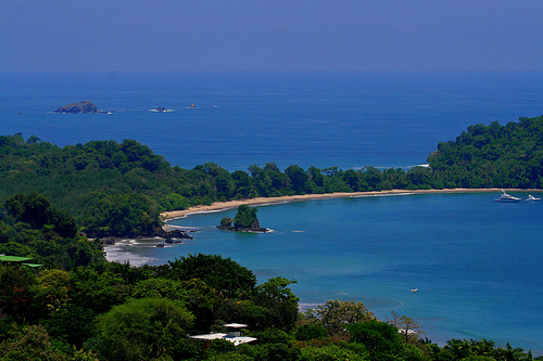
Manuel Antonio National Park, located on Costa Rica's central Pacific coast in the province of Puntarenas, is one of the country's smallest yet most biodiverse and visited protected areas. Spanning approximately 682 hectares (1,685 acres) of land and an additional 55,000 hectares of marine territory, it combines lush tropical rainforests, pristine white-sand beaches, mangrove swamps, and vibrant coral reefs into a compact ecological haven. Known for its stunning scenery and abundant wildlife, the park attracts over a million visitors annually, making it the most popular national park in Costa Rica and a symbol of the nation's commitment to ecotourism and conservation.
The area's history traces back to Spanish exploration in the early 16th century, when explorers like Ponce de León charted the territories around Quepos and Manuel Antonio in 1519, noting their natural riches. Over the centuries, the land served various purposes, including as banana plantations and coconut farms. By the mid-20th century, foreign owners restricted local access to the beaches, sparking community pressure that led to the park's establishment. In 1972, through Law No. 5100, the Costa Rican government designated it as the "National Park Beaches Recreation Manuel Antonio," initially focusing on recreational access but evolving into a full-fledged conservation area. This move highlighted Costa Rica's pioneering role in environmental protection, with the park becoming a model for balancing tourism and preservation. Since then, it has faced challenges like habitat fragmentation but has benefited from community-led initiatives, including wildlife corridors and sustainable practices.
Situated about 157 kilometers (97 miles) south of San José and 7 kilometers east of Quepos, the park occupies a peninsula with elevations ranging from sea level to around 160 feet (50 meters). Its landscape includes rugged cliffs, winding rivers, and a mix of primary and secondary rainforests transitioning into mangrove swamps and coastal areas. A notable feature is Punta Catedral (Cathedral Point), a former island now connected to the mainland by a tombolo—a sandy isthmus formed by sediment accumulation—separating key beaches like Playa Espadilla Sur and Playa Manuel Antonio. The park also encompasses offshore islands, a 14-hectare lagoon, and marine environments with coral reefs. Annual precipitation averages 151 inches (3,900 mm), with the dry season (mid-December to April) offering clearer weather and the rainy season (May to November) bringing lush greenery. Temperatures hover between 81°F (27°C) and 86°F (30°C) year-round.
Manuel Antonio is a biodiversity hotspot, protecting one of the few remaining areas of tropical lowland wet forest on Central America's Pacific coast. It hosts over 346 plant species, including guácimo colorado, madroño, cenízaro, cedar, locust trees, vines, lianas, manzanillo, beach almond, copey, and coconut palms, as well as three mangrove types: red, piñuela, and gentleman. Fauna is equally diverse, with 109 mammal species, 352 bird species, and varied reptiles, amphibians, and marine life. Iconic mammals include the endangered red-backed squirrel monkey (mono tití, found only here and in Corcovado), white-faced capuchin, spider, and mantled howler monkeys, two- and three-toed sloths, raccoons, white-nosed coatis, and agoutis. Birds range from brown pelicans and kingfishers to fiery-billed aracaris, chestnut-mandibled toucans, lineated woodpeckers, and red-capped manakins. Reptiles and amphibians feature iguanas, ctenosaurs, jesus christ lizards, anoles, geckos, smoky jungle frogs, and red-eyed leaf frogs. Marine biodiversity includes colorful fish, sea turtles (like green sea turtles), dolphins, and occasional whales, supported by healthy coral reefs. The park's small size necessitates wildlife corridors for species like squirrel monkeys to access surrounding habitats.
The park's main draws are its beaches and trails. Beaches include Playa Manuel Antonio, a half-mile crescent of white sand ideal for swimming, snorkeling (especially at the sides for marine life and corals), and relaxation; Playa Espadilla Sur, wider with stronger waves for surfing; Playa Gemelas, divided by rocks with evolving stone fragments; and Playa Puerto Escondido, accessible via trail with tide pools teeming with sponges, corals, crabs, and over 100 fish species. Trails, totaling several kilometers, are well-maintained and easy (some wheelchair-adapted), including the main trail to beaches (20-30 minutes), the 1.2 km Punta Catedral loop with panoramic viewpoints and pre-Columbian turtle traps (visible at low tide), the 1.3 km Sendero Perezoso (sloth trail), and the 1.3 km Sendero Mirador (overlook trail) to a headland above Playa Puerto Escondido. Note: Punta Catedral trail is temporarily closed. Other attractions include a seasonal waterfall, mangroves, Punta Serrucho (a jagged volcanic rock formation on a tectonic fault), and La Trampa (an indigenous turtle trap). Activities encompass hiking, birdwatching (best early morning or late afternoon), snorkeling, scuba diving, and guided tours for deeper insights into flora, fauna, and culture.
Established to protect endangered species and ecosystems, the park addresses threats like habitat loss, climate change, and overtourism through initiatives like wildlife corridors, sustainable tourism practices, and community involvement. Regulations prohibit feeding animals, removing resources, fires, weapons, alcohol, smoking, drugs, umbrellas, balls, tents, hammocks, and most food (only non-alcoholic drinks in reusable bottles allowed to minimize environmental impact). Visitors are urged to follow Leave No Trace principles, maintain distances from wildlife, and avoid toxic manzanillo trees. Improvements, such as a new septic system in 2019, prevent beach contamination during high visitation. The park's marine reserves safeguard coral reefs and sea turtles, emphasizing its role in broader conservation.
The park is open Wednesday to Monday from 7:00 a.m. to 3:00 p.m., closed Tuesdays. Tickets must be purchased online in advance via https://serviciosenlinea.sinac.go.cr/ (create an account; valid once, present ID at entry). Visitor limits: 600 weekdays, 800 weekends/holidays (may be exceeded during peaks like Easter, Christmas). No parking inside; nearby lots cost ₡3,000-₡4,000 (~$5-7). Taxis from Quepos/Manuel Antonio hotels: $5-10. Best time: Dry season for clear weather; rainy season for fewer crowds and vibrant greenery. Arrive early (7:00-7:30 a.m.) during peaks to avoid lines and scammers impersonating staff. A full visit takes 5-7 hours; bring sunscreen, water, insect repellent, binoculars, camera, and proper footwear (no sandals on trails). Guided tours (recommended for spotting wildlife; 2.5-3 hours, $70/adult standard, $85 private) include telescopes and education; book via official sources. Services: Drinking water, showers/dressing rooms (no soap/shampoo), health services, interpreted trails, viewpoints. Nearby: Quepos for markets/seafood, eco-lodges/hotels, adventures like zip-lining, rafting.