Source: Cordillera de Talamanca
Total Length: 108 km
The Pacuare River, or Río Pacuare, is one of Costa Rica's most iconic waterways, renowned for its stunning natural beauty, thrilling whitewater rapids, and rich biodiversity. Flowing through dense tropical rainforests from the central highlands to the Caribbean coast, it offers a blend of adventure, ecological significance, and cultural history. Often ranked among the world's top rivers for scenic rafting by outlets like National Geographic, the Pacuare spans about 108-129 kilometers (67-80 miles) and serves as a vital corridor for wildlife while facing ongoing conservation challenges from development pressures.
Originating in the Cordillera de Talamanca mountain range in eastern
central Costa Rica at coordinates approximately 9.611° N, -83.636° W,
the Pacuare River flows northeastward for around 108 km (67 mi) before
emptying into the Caribbean Sea near Siquirres at 10.22° N, -83.28° W.
Some sources cite a total length of up to 129 km (80 mi) with a basin
area of about 900 km². The river descends from high elevations in the
Talamanca region, dropping over 370 meters (1,200 ft) in its lower
sections alone, creating dramatic canyons, gorges, and waterfalls. Key
tributaries include the left-bank Rio San Rafael, Rio Plantanillo, Rio
Pacayitas, Quebrada Grande, and Rio Siquirres, as well as the right-bank
Rio Madre de Dios.
The river is divided into roughly 16 sections,
with the most commonly navigated ones being the Upper Upper (26 km with
Class II-IV rapids), Upper (10 km, technical Class IV-V), and Lower (37
km, Class III-IV). Surrounded by steep, forested slopes and
first-generation rainforests, the Pacuare features highlights like the
Dos Montañas Canyon, Huacas River Gorge, and numerous cascading
waterfalls that plunge directly into the river. The landscape
transitions from mountainous terrain to lowland jungles, with vegetation
shifting from sabe trees and red Indio desnudo (naked Indian tree) in
upper areas to heart of palm, coconut palms, and banana trees
downstream.
Exploration of the Pacuare began in earnest in the late 20th century.
The first documented kayaking descent occurred in September 1980 by
Polish explorers Piotr Chmielinski and Jerzy “Yurek” Majcherczyk as part
of the CanoAndes team, marking the initial modern traversal of its upper
and lower sections. This was followed by the inaugural rafting
expedition in February 1981, led by American and Canadian guides Nick
Hershenow, Sharon Hester, Jerry Kaufman, and Rudy Koller, using a small
Avon raft and kayak over five days.
Commercial rafting emerged
shortly after, with Michael Kaye founding Costa Rica Expeditions in 1978
and launching trips on the Pacuare by 1981-82. Rafael Gallo, a former
employee, established Rios Tropicales in the early 1980s, and other
companies like Aventuras Naturales and Tico's River Adventures followed
in the mid-1980s. By 1985, Rios Tropicales ran its first commercial
kayaking trip, transporting gear via oxen-pulled carts. The 1988
publication of The Rivers of Costa Rica by Gallo and Michael Mayfield
became a key guide for the region's waterways.
The river's history is
also marked by seismic events and human development. A 7.7 magnitude
earthquake in 1991, centered near Limón, cracked the bedrock in Dos
Montañas Canyon, influencing later conservation outcomes. International
events like the 1991 Rainforest Festival and the 1998 and 2011 IRF World
Rafting Championships highlighted the Pacuare globally. Nearby, the
Pacuare Reserve was founded in 1989 by John Denham through the
Endangered Wildlife Trust, initially acquiring 688.6 hectares (later
expanded to 1700 acres) to protect coastal forests and sea turtles,
though not directly on the river itself but along the adjacent Caribbean
coastline.
The Pacuare River corridor is a biodiversity hotspot, enveloped in
pristine tropical rainforests that support over 2,700 species of plants
and animals. Much of the surrounding forest is untouched
first-generation rainforest, creating a vibrant ecosystem with high
humidity, diverse flora, and interconnected habitats. The river's lower
reaches and adjacent lagoons, like those near the Pacuare Reserve, form
quasi-isolated environments rich in aquatic and terrestrial life.
Wildlife is abundant and diverse. Mammals include elusive big cats
like jaguars and ocelots (occasionally spotted near the Huacas Gorge),
as well as anteaters, raccoons, river otters, capuchin monkeys, howler
monkeys, sloths, and iguanas. The lower Pacuare area is a hotspot for
Antillean manatees, with ongoing monitoring by organizations like the
Smithsonian Tropical Research Institute. Reptiles feature venomous
snakes such as coral snakes, bushmasters, and fer-de-lance, alongside
non-venomous species like the laura and sopy lota. Birdlife is prolific,
with over 252 species including chestnut-mandibled toucans, parakeets,
oropendolas, kingfishers, tiger herons, blue herons, hawks, ospreys,
king vultures, sunbitterns, and snowy egrets. Insects like the blue
morpho butterfly add to the vibrancy. Nearby coastal areas, including
the Pacuare Reserve's 6 km of beach, are critical nesting sites for
endangered leatherback sea turtles (March-July nesting, June-September
hatching), with over 980,000 hatchlings released historically.
The Talamanca Mountains region, encompassing the Pacuare's headwaters,
hosts additional species diversity, as documented in studies of
protected areas like Barbilla National Park. Organizations like the
Rivers and Forests Alliance (RAFA) focus on reforestation and
biodiversity preservation in the Pacuare watershed.
Regarded as one of the world's top five rivers for whitewater
rafting, the Pacuare offers Class III-IV rapids interspersed with calm
pools, making it accessible yet exciting for various skill levels. Trips
can last from one to three days, featuring rapids like Upper and Lower
Huacas (Class IV), Double Drop (Class III), and Cimarones (Class IV),
alongside breathtaking scenery of gorges and waterfalls. The Upper
sections appeal to advanced kayakers with Class V challenges, while the
Lower is ideal for commercial tours.
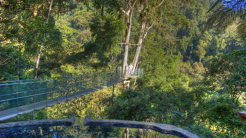
Other activities include
whitewater kayaking, riverboarding, hiking in adjacent rainforests,
birdwatching, and wildlife spotting. Eco-lodges like Pacuare Lodge
provide luxurious bases for multi-day adventures, emphasizing
sustainable tourism. The river's accessibility from Turrialba makes it a
hub for adventure seekers.
Conservation has been central to the Pacuare's story, driven by
threats from hydroelectric dams proposed by the Instituto Costarricense
de Electricidad (ICE) starting in 1986. Activism, led by figures like
Rafael Gallo through Pro-Rivers (1989-1994), included Earth Day protests
in 1988 and 1990, blocking dynamiting at Dos Montañas Canyon, and legal
actions mandating environmental impact studies— a precedent that amended
national law. The 1991 earthquake and a 1993 study deemed the dam
unfeasible.
Further protections came in 2005 when Turrialba voted
against new dams, and in 2015, President Luis Guillermo Solis signed a
25-year decree safeguarding the Pacuare and Savegre rivers from
hydroelectric projects (through 2040). Groups like RAFA (founded 2021)
continue reforestation and advocacy, while the Pacuare Reserve, managed
by Ecology Project International since its 1989 inception, focuses on
sea turtle conservation, long-term monitoring (e.g., Agami herons), and
education, protecting over 1,700 acres of coastal habitat linked to the
river's ecosystem. These efforts have shifted Costa Rica toward
renewables like wind and solar, preserving the river's ecological
integrity.