Location: Turrialba County, Cartago province Map
Elevation: 3,340 m (10,958 ft)
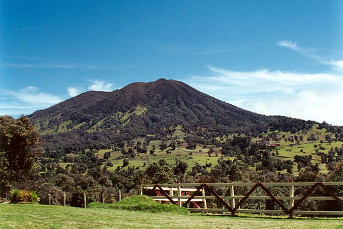
Turrialba Volcano is one of Costa Rica's most active stratovolcanoes, located in the Cartago Province, approximately 50-65 km east of the capital, San José. It forms part of the Central Volcanic Mountain Range and is the easternmost of the country's Holocene volcanoes, sitting across a broad saddle northeast of the neighboring Irazú Volcano. With a summit elevation of 3,340 meters (10,958 feet) above sea level, it is the second-highest volcano in Costa Rica and covers an area of about 500 km². The volcano is encompassed within Turrialba Volcano National Park, managed by SINAC, which protects its diverse ecosystems ranging from cloud forests to high-altitude páramo. The average temperature at the summit is around 16°C (60°F), with frequent cloud cover and high humidity. Nearby features include the Guayabo National Monument, an important archaeological site with pre-Columbian ruins, located on the volcano's slopes.
Turrialba is a large, vegetated basaltic-to-dacitic stratovolcano
with a composite structure, featuring a summit depression that measures
about 800 x 2,200 meters and is breached to the northeast. The summit
hosts three well-defined craters aligned in a southwest-northeast
direction: the active West Crater (also known as Cráter Oeste or La
Quemada), the Central Crater, and the inactive East Crater. The West
Crater is the primary site of activity, with multiple vents including
Boca 2010 on the west wall, Boca 2011 on the north wall, and Boca 2012
on the east wall. This crater has undergone significant morphological
changes, deepening to 220 meters in 2019 before filling with debris from
collapses, reducing its depth to around 130 meters by late 2020.
Fumaroles are abundant, particularly in the eastern sector, emitting
steam and sulfur gases at temperatures up to 440°C, with some vents
reaching 800°C historically.
Geologically, Turrialba is situated in a
subduction zone with continental crust thicker than 25 km, and its rocks
range from basalt and picro-basalt to andesite, basaltic andesite, and
dacite. The volcano exhibits an open magmatic system with hydrothermal
influences, leading to weakened summit rocks from alteration, rainfall,
and fluid interactions. Cracks and fractures trend in various directions
(E-W, SW-NE, NW-SE, N-S), some up to 12 cm wide and over 100 meters
long, associated with the Ariete fault. Two pyroclastic cones are
present on the southwest flank, and the edifice has experienced major
explosive eruptions and debris avalanches in the past. Gas emissions are
dominated by CO₂ (over 99%), with low SO₂ and traces of H₂S, H₂, CO, and
He; SO₂ flux varies from 100-4,000 tons per day, depending on activity
levels. Acid rain from emissions has pH values as low as 2.8, causing
vegetation damage up to 4 km away and affecting crops like onions as far
as 18 km southwest. Incandescence is often visible at night from
high-temperature fumaroles, and thermal anomalies have been detected via
satellite data.
Seismicity includes low-frequency volcanic
earthquakes, long-period events, volcano-tectonic quakes, hybrids,
tornillos, and tremors, often linked to fluid movements and emissions.
Deformation shows ongoing subsidence and contraction of the massif, with
slight inflation in some periods. Monitoring is handled by OVSICORI-UNA,
with stations near the summit.
Turrialba has a long history of activity, with at least five major
explosive eruptions in the last 3,500 years and at least 10 significant
ones in the past 7,000 years. Outcrops reveal at least 20 eruptions from
basalt to dacite in the summit area, many producing pyroclastic units.
The volcano was dormant for about 130 years after its last major
magmatic eruption in 1864-1866, which included ash and pyroclastic
surges. Fumarolic activity persisted from the 1980s, with temperatures
of 85-93°C in the craters. Seismicity increased in 1996, marking the
possible start of a new phase, with swarms and plumes up to 2 km high by
2007.
Eruptions often eject hydrothermally altered lithics
(85%+), with minor juvenile magmatic components (3-12%). Plumes
typically rise 500 m to 2 km, drifting based on winds, and have caused
aviation disruptions, including airport closures in San José.
Activity peaked from 2014-2019 with weak ash explosions and emissions, then subsided after 2019, shifting to primarily passive degassing and occasional phreatic events. A small phreatic eruption occurred on 17 July 2022, with an ash emission rising less than 500 m and drifting southwest. In March 2025, Turrialba experienced a minor ash emission, its first eruption since 2022, amid increased activity that also affected nearby Poás Volcano. As of September 2025, the volcano remains in a state of unrest, with ongoing monitoring for seismic and gas changes. No major eruptions have been reported in 2023-2024, but persistent fumarolic activity and low-level seismicity continue.
Turrialba's activity has led to vegetation damage, acid rain affecting agriculture, and ashfall impacting communities within 30 km (population ~672,000). Lahars have occurred in drainages like Río Aquiares, mobilizing debris. The national park offers hiking trails (when safe), but access to the summit is often restricted due to hazards. Tourism focuses on viewpoints and eco-tours, highlighting the volcano's role in Costa Rica's biodiversity and geothermal potential.