Location: El Petén Department Map
El Mirador Archaeological Site, located deep in the dense rainforests of the Petén Basin in northern Guatemala, is one of the most significant and enigmatic pre-Columbian Maya cities. Often referred to as the “Cradle of Maya Civilization” or the “Lost City of the Maya,” El Mirador was a thriving metropolis during the Middle and Late Preclassic periods (1000 BCE–250 CE), predating many of the more famous Classic Maya sites like Tikal by centuries. Its remote location, monumental architecture, and ongoing archaeological discoveries make it a fascinating window into the origins of Maya civilization.
El Mirador is situated in the Mirador Basin, a vast lowland region in
the northern part of the Petén Department, near Guatemala’s border with
Mexico. The site lies approximately 60 kilometers (37 miles) north of
the modern town of Flores and 7 kilometers (4.3 miles) south of the
Mexican border, within the Maya Biosphere Reserve, one of Central
America’s largest protected rainforest areas. The basin is characterized
by dense tropical jungle, seasonal swamps (bajos), and limestone karst
terrain, with no permanent rivers or lakes, making water management a
key challenge for the ancient Maya.
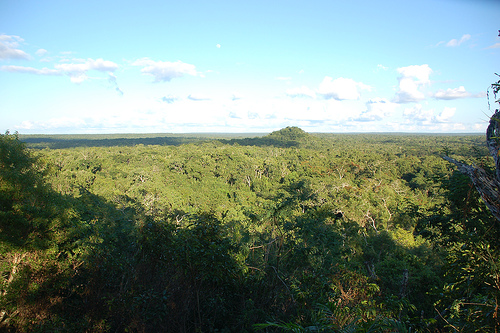
The site’s remote location
has preserved it from modern development but also makes access
difficult. El Mirador is surrounded by six types of tropical forest,
home to over 300 tree species, 200 animal species, and five of the six
Central American big cats (jaguar, puma, ocelot, margay, and
jaguarundi). This biodiversity, combined with the site’s isolation,
creates a sense of stepping back in time, though it also poses
logistical challenges for archaeologists and visitors.
The
climate is hot and humid, with temperatures averaging 25–35°C (77–95°F).
The dry season (November–April) is the best time for visits, as the
rainy season (May–October) brings muddy trails and flooding,
complicating treks and excavations.
El Mirador flourished during the Middle Preclassic (1000–400 BCE) and
Late Preclassic (400 BCE–250 CE) periods, making it one of the earliest
major Maya centers. At its peak, from around 200 BCE to 150 CE, the city
may have supported a population of up to 80,000–100,000 people, rivaling
or surpassing modern urban centers in Guatemala. It was a political,
economic, and cultural hub, connected to other Preclassic cities like
Nakbé, Tintal, and Wakná through an extensive network of raised
causeways (sacbeob), some stretching over 20 kilometers.
The
city’s rise is attributed to its strategic location in the Mirador
Basin, which offered fertile land for agriculture (maize, beans, squash)
and access to trade routes for jade, obsidian, and other goods. El
Mirador’s rulers likely wielded significant power, overseeing monumental
construction projects like the massive pyramids La Danta and El Tigre,
which remain among the largest structures ever built by the Maya. The
city’s sophisticated urban planning, including water collection systems
and causeways, suggests a highly organized society with advanced
engineering and astronomical knowledge.
El Mirador was
mysteriously abandoned around 150–250 CE, near the end of the Preclassic
period. Theories for its collapse include environmental degradation
(deforestation and soil exhaustion), overpopulation, climate change
(prolonged droughts), or social upheaval. The city was briefly
reoccupied in the Late Classic period (600–900 CE), but only on a small
scale, and it was largely forgotten until its rediscovery in 1926 by
archaeologists. Major excavations began in the 1960s under Harvard
University and intensified in the 1980s with the RAINPEG Project
(Regional Archaeological Investigation of the North Petén, Guatemala),
led by Dr. Richard Hansen, revealing the site’s immense scale and
significance.
Today, El Mirador is considered a cornerstone of
Maya archaeology, offering evidence that complex Maya
civilization—complete with writing, monumental architecture, and urban
planning—emerged earlier than previously thought, challenging
traditional views of the Classic period (250–900 CE) as the Maya’s peak.
El Mirador is one of the largest Maya sites, covering
approximately 26 square kilometers (10 square miles) in its civic
center, with thousands of structures, many still unexcavated and
shrouded in jungle. Its monumental architecture, advanced urban
infrastructure, and early written texts distinguish it as a
Preclassic masterpiece. Below are the key features:
La Danta
Pyramid Complex
Description: The La Danta Complex is El Mirador’s
most iconic feature, often cited as the largest pyramid in the Maya
world by volume and one of the largest ancient structures globally.
Standing at 72 meters (236 feet) tall, with a base covering 18
hectares (44 acres), it surpasses Egypt’s Great Pyramid in total
volume (though not height). The complex consists of three stepped
platforms, with the uppermost temple offering panoramic views of the
jungle and distant pyramids.
Significance: La Danta likely served
as a ceremonial and political center, symbolizing the power of El
Mirador’s rulers. Its construction required millions of cubic meters
of fill, moved without wheels or draft animals, showcasing the
Maya’s engineering prowess.
Current State: Partially excavated,
the pyramid is covered in vegetation, with exposed stonework
revealing intricate details. Climbing La Danta is a highlight for
visitors, though it requires caution due to steep, uneven steps.
El Tigre Pyramid Complex
Description: The El Tigre Complex,
located west of La Danta, is another massive structure, standing 55
meters (180 feet) tall with a base of 149,000 square meters. It
faces La Danta, creating a symbolic east-west axis that may reflect
astronomical or cosmological alignments.
Significance: El Tigre
likely served religious and administrative functions, with its broad
plaza used for rituals and gatherings. Its size and orientation
suggest it was a counterpart to La Danta in the city’s urban plan.
Current State: Like La Danta, El Tigre is partially excavated, with
jungle overgrowth adding to its mystique. Visitors can climb it for
views of the surrounding canopy and La Danta.
Causeways
(Sacbeob)
Description: El Mirador is linked by a network of
raised limestone causeways, some up to 40 meters wide and 20
kilometers long, connecting the city to satellite sites like Nakbé
and Tintal. These roads facilitated trade, communication, and
military movement.
Significance: The causeways indicate a high
level of urban planning and regional integration, with some scholars
suggesting El Mirador was the capital of a Preclassic “superstate.”
They also helped manage seasonal flooding in the bajos.
Current
State: The causeways are partially overgrown but visible during
treks, offering a tangible sense of the city’s vast reach.
Stela 2 and Early Writing
Description: In 1990, the UCLA RAINPEG
expedition uncovered Stela 2, a carved stone monument with one of
the earliest known Maya texts, dating to around 300 BCE. The stela
features glyphs and iconography, including depictions of
mythological scenes.
Significance: The text provides evidence of
a sophisticated writing system in the Preclassic period, predating
Classic Maya inscriptions. It suggests El Mirador was a center of
intellectual and cultural innovation.
Current State: The stela is
preserved in situ or in a museum (depending on conservation
efforts), with replicas available for study.
Residential and
Civic Structures
Description: The site includes thousands of
structures, from elite palaces to humble homes, organized around
plazas and courtyards. Notable complexes include the Cascabel Group
(elite residences) and the Central Acropolis (administrative
buildings).
Significance: These structures reveal a stratified
society with a ruling class, artisans, and laborers. The presence of
ballcourts suggests ritual games, a key Maya tradition.
Current
State: Most structures remain unexcavated, buried under earth and
vegetation, with only major complexes partially cleared.
Water Management Systems
Description: El Mirador’s engineers
built reservoirs, canals, and catchment systems to capture
rainwater, critical in a region without rivers. These systems
supported agriculture and urban life.
Significance: The water
infrastructure highlights the Maya’s environmental adaptation,
enabling a large population in a challenging landscape.
Current
State: Some reservoirs are visible, though silted or overgrown,
offering insight into ancient engineering.
El Mirador is a pivotal site for understanding the origins of Maya
civilization, offering several key insights:
Preclassic
Powerhouse: El Mirador’s size, complexity, and early innovations
(writing, pyramids, causeways) suggest it was a foundational center,
possibly the capital of a regional state. It predates Tikal by 800–1,200
years, challenging the view that the Classic period was the Maya’s apex.
Cosmological Design: The city’s layout, with pyramids aligned to
celestial events and causeways linking sacred sites, reflects Maya
beliefs about the cosmos, where architecture mirrored the heavens and
underworld.
Collapse and Legacy: El Mirador’s abandonment around 150
CE marks the end of the Preclassic period, possibly due to ecological
collapse or social unrest. Its decline may have paved the way for
Classic centers like Tikal and Calakmul, which inherited its cultural
and technological traditions.
Conservation Challenges: The site’s
location in the Maya Biosphere Reserve makes it a focal point for
conservation debates. Illegal logging, looting, and climate change
threaten the ruins, while tourism and archaeological work raise
questions about balancing access and preservation. Efforts by Dr.
Richard Hansen and the Global Heritage Fund aim to protect the Mirador
Basin through sustainable tourism and reforestation.
El Mirador is on
Guatemala’s tentative list for UNESCO World Heritage status, recognized
for its “exceptional natural and cultural characteristics” as a cradle
of Mesoamerican civilization.
El Mirador remains largely unexcavated, with only 10–15% of the site
cleared, leaving much of it buried under jungle. This “lost city”
quality enhances its allure but complicates research. Ongoing
excavations, led by teams like the Mirador Basin Project, focus on:
Mapping the site using LiDAR (Light Detection and Ranging), which
has revealed hidden structures and causeways.
Conserving exposed
monuments like La Danta and El Tigre, which are vulnerable to erosion
and looting.
Studying artifacts, including ceramics, jade, and
stelae, to understand Preclassic society.
The site’s remoteness
protects it from mass tourism but limits funding and infrastructure.
Archaeologists estimate that fully uncovering El Mirador could take
decades or centuries, making it a long-term project.
Visiting El Mirador is a challenging but rewarding adventure,
requiring physical stamina and a sense of exploration. The site is
accessible only by a multi-day jungle trek or helicopter, as no roads
lead directly to it. Here’s what to expect:
Trekking:
Route:
Most visitors start from Carmelita, a village 40 kilometers south of El
Mirador, reachable by bus or 4x4 from Flores (2–3 hours). The standard
trek is a 5–6-day round trip, covering 80–100 kilometers through dense
jungle, mud, and swamps.
Experience: The trek involves camping in
basic conditions, with mules carrying supplies. Guides point out
wildlife (monkeys, toucans, jaguar tracks) and smaller ruins en route,
like El Tintal. The jungle is hot, humid, and buggy, with mosquitoes and
ticks a constant presence.
Arrival: Reaching El Mirador feels like
discovering a lost world. Visitors can climb La Danta and El Tigre,
explore plazas, and see unexcavated mounds, all while surrounded by
jungle sounds. The view from La Danta’s summit, with the canopy
stretching to the horizon, is unforgettable.
Cost: Guided treks cost
$250–$400 USD, including guides, mules, food, and tents. Book through
reputable operators in Flores, like Coop Carmelita or Tikal Go.
Helicopter:
Route: Helicopter tours from Flores take 30–45 minutes,
landing at a cleared strip near the site. Day trips or overnight stays
are available.
Experience: This option skips the trek’s hardships,
offering aerial views of the jungle and pyramids. It’s ideal for those
short on time or with mobility issues but misses the immersive jungle
experience.
Cost: $500–$1,000 USD per person, depending on group size
and duration.
Highlights:
Climbing La Danta for sunrise or
sunset views.
Exploring the Central Acropolis and imagining the
city’s ancient bustle.
Learning from guides about Maya cosmology and
recent discoveries.
Camping under the stars, with the jungle’s
nocturnal sounds as a backdrop.
Challenges:
The trek is
physically demanding, requiring fitness and resilience to heat, mud, and
insects.
Basic facilities (no showers, pit latrines) and limited food
options (beans, rice, tortillas).
Risk of rain, even in the dry
season, which can turn trails into quagmires.
Location: Mirador Basin, Petén Department, northern Guatemala, near
the Mexican border.
Getting There:
By Trek: From Flores to
Carmelita (2–3 hours by bus/4x4), then a 5–6-day trek (80–100 km round
trip).
By Helicopter: From Flores airport, 30–45 minutes, arranged
through tour operators.
Entrance Fee: Included in trek or helicopter
costs; no separate park fee.
Hours: No formal hours, but treks
typically start early morning, and helicopter tours operate daytime.
Best Time to Visit:
Dry Season (November–April): Less mud, easier
trekking, but book early due to demand.
Rainy Season (May–October):
Avoid unless experienced, as trails become nearly impassable.
Accommodation:
Trek: Camping in tents at designated sites near El
Mirador and en route (e.g., El Tintal).
Helicopter: Day trips return
to Flores; overnight tours use basic camps or nearby lodges.
What to
Bring:
Lightweight, quick-dry clothing, sturdy hiking boots, and a
hat.
Insect repellent, sunscreen, and a mosquito net.
Water
purification tablets, high-energy snacks, and a reusable water bottle.
Headlamp, rain gear, and a small backpack for essentials.
Camera and
binoculars for wildlife and views.
Tips:
Book with reputable
operators (e.g., Coop Carmelita, Tikal Go) to ensure safety and support
local communities.
Train physically for the trek, focusing on
endurance and heat tolerance.
Respect the site: Do not touch
artifacts or climb fragile structures.
Pack light, as mules have
weight limits, but include layers for cool nights.
Learn basic
Spanish for communication with guides and porters.
Largest Pyramid: La Danta’s volume (2.8 million cubic meters) exceeds
that of Egypt’s Great Pyramid, making it one of the largest ancient
structures by mass.
Early Writing: Stela 2’s glyphs, dating to 300
BCE, are among the earliest Maya texts, showing a fully developed script
centuries before the Classic period.
Lost City: El Mirador was
rediscovered in 1926 but remained largely unexplored until the 1960s,
earning its “lost city” moniker.
Causeway Network: The sacbeob
system, stretching over 100 kilometers, is one of the earliest examples
of Maya infrastructure, rivaling Roman roads in scope.
Biodiversity
Haven: The Mirador Basin’s wildlife, including jaguars and scarlet
macaws, makes visits a dual archaeological and ecological adventure.
Conservation Debate: Proposals for a tourist train to El Mirador have
sparked controversy, with critics arguing it could harm the jungle and
local communities, while supporters see it as a way to fund
conservation.