Location: Juneau Map
Area: 3,283,246 acres (13,287 km²)
Official site
Fees and permits
There are no entry
fees for non-commercial users of the park.
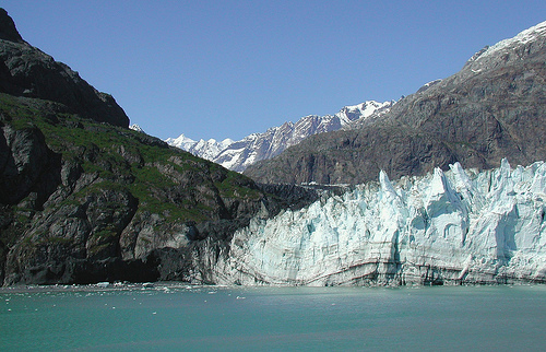
The Glacier Bay National Park is a national park in the USA in
southern Alaska, near Juneau, in the so-called Alaska Panhandle.
There are over 50 named glaciers in the park, 7 of which extend into
the tidal waters of the bay called Glacier Bay, which is crossed by
fjords such as Tarr Inlet. Chunks of ice over 50 meters high often
break off and fall explosively into the water (calving).
The
region around Glacier Bay was initially protected as a national
monument on February 25, 1925. The national park, which was created
in 1980 by the Alaska National Interest Lands Conservation Act, was
expanded by 2,100 km² and covers an area of 13,287 km². A large part
of it (10,784 km²) is designated as a wilderness area. The park is
an IUCN Category V protected area (Protected Landscape/Protected
Marine Area). The park is classified by UNESCO as part of an
international biosphere reserve and a world natural heritage site.
In 1979, Canada's Kluane National Park, along with the US
Wrangell-St. Elias National Park, was declared a transboundary
natural heritage site. This world natural heritage was then
supplemented in 1992 by the Glacier Bay National Park and in 1994 by
the Canadian Tatshenshini-Alsek Provincial Park to form a joint and
coherent world natural heritage. A small extension area in the far
west of the national park is designated with the lower protection
status of a National Preserve. Hunting was already common here
before it was placed under protection, and it is still permitted.
The national park's glaciers are of scientific importance
because they now mark the retreat of a smaller ice age that dates
back 4,000 years. When Captain George Vancouver explored the region
in 1794, the bay was almost completely filled with ice from
glaciers. The ice was several kilometers wide and over 1000 meters
high. In 1879, less than 100 years later, the naturalist John Muir
discovered that the glaciers had retreated significantly. The ice
mass now known as Muir Glacier has shortened by 77 kilometers in
these 85 years. Today this retreat of the glaciers has slowed. Three
glaciers continue to retreat, while eight are growing longer.
Scientists are researching the influence of glacier movement on the
global climate and the flora in the areas released by the glaciers.
The approximately 380,000 visitors annually arrive mostly on
cruise ships, or in some cases on ferries operated by the National
Park Service. The only road leads from the small airport through the
town of Gustavus, both outside the park boundaries in the southeast,
to the visitor center, the campground and the Glacier Bay Lodge, the
only hotel in the park.
There are over 100 glaciers in the
four mountain ranges. The highest point in the park is on the flank
of the 4,663 meter high Mount Fairweather, whose summit lies outside
the park boundaries on the Canadian side. Wolves, brown bears, black
bears and mountain goats are characteristic large animal species of
the national park. Numerous marine mammals such as killer whales,
humpback whales, gray whales, sea otters, seals and Steller sea
lions can also be found in the coastal waters. The area is also one
of the few places where the endangered Short-billed Auk still
occurs.
Other mammals in the area include snowshoe hares,
gray marmots, beavers, ursons and red squirrels. The Sitka
black-tailed deer has its northernmost occurrence in this region.
Since the 1960s, moose have also appeared in the area, which were
not previously found here. The coyote is also a recent immigrant. In
the near future, pumas could also advance further and colonize the
park. Other predators such as wolverine, North American river otter,
mink and red fox also live in the park. Canada lynx, on the other
hand, are rare.
The only lodging that is within the park is the
Glacier Bay Lodge in Bartlett Cove and a handful of lodges in Dry
Bay. The town of Gustavus, 10 miles from Bartlett Cove, has a
handful of additional options.
Lodging
Alsek River Lodge
(Summer only), ☎ +1 907 784-3451. 60 miles southeast of Yakutat,
Alaska at Dry Bay in Glacier Bay National Preserve. The Alsek River
Lodge is a small rustic lodge primarily focusing on guided hunting,
photography & sport fishing activities and services. Access is by
small plane.
Glacier Bay Lodge (Mid-May to mid-September),
toll-free: +1-888-229-8687. The Glacier Bay Lodge is in Bartlett
Cove and offers overnight accommodations, a restaurant, gift shop,
fuel sales (gasoline, #2 diesel, and white gas), and a daily vessel
tour to the park's spectacular tidewater glaciers.
Johnny's East
River Lodge (Summer only), ☎ +1 907 463-1288. 60 miles southeast of
Yakutat, Alaska at Dry Bay in Glacier Bay National Preserve.
Johnny's East River Lodge is a small wilderness lodge focusing on
sport fishing and wildlife viewing activities and services. Access
is by small plane.
Northern Lights Haven (Summer only), ☎ +1 253
564-4583. 60 miles southeast of Yakutat, Alaska at Dry Bay in
Glacier Bay National Preserve, Northern Lights Haven is a small
rustic lodge primarily focusing on sport fishing activities and
services. Access is by small plane.
Camping
2 Bartlett
Cove Campground. A free walk-in campground with bear-resistant food
caches, firewood, and a warming hut, is at Bartlett Cove. No
reservations are accepted, but a permit is required. Campground
permits are issued at the Visitor Information Station on a
first-come, first-served basis. Wheelbarrows are available to help
transport gear between the parking area, dock, and campground. Stays
are limited to 14 days. Free.
Backcountry
All campers
(including kayakers) are required to attend a camper orientation,
held daily upon request at the Bartlett Cove Visitor Information
Station near the dock. This session is for your benefit: to answer
your questions, provide you with a tide table, inform you of special
wildlife and safety closures or to assist in planning your trip. You
will be asked to fill out a backcountry registration form at that
time and a wilderness survey form when you return from your trip.
The area around Glacier Bay, southeast of Alaska, was proclaimed a National Monument on February 5, 1925. Later, in 1980, it received the designation Glacier Bay National Park and Preserve through the Congress passed the Alaska National Interest Lands Conservation Act. In 1986, UNESCO proclaimed the area a Biosphere Reserve, and in 1992 it was incorporated into the World Heritage Site, within the transboundary site called Kluane / Wrangell-St Elias / Glacier Bay / Tatshenshini-Alsek.
The park covers an area of 13,287 km², of which 10,784
km² are considered wild areas.
There are no roads that penetrate
the park and the easiest way to access it is via National Park Service
ferries—which arrive across Cross Sound or Icy Sound—or by plane, using
the town's runway. by Gustavus. Despite poor communications, 380,000
visitors come to the park each year.
The descent of the glaciers
from the snow-capped peaks to the bay creates one of the best landscapes
in the world to observe the creation of icebergs. The most famous
glacier in the bay is the Muir Glacier, which moves 3 kilometers per
year and is 80 meters thick. Until 1750 the bay was an immense glacier.
Explorer George Vancouver discovered Icy Sound in the south of the
bay when he hit an ice sheet in 1794. At that time, Glacier Bay was
completely covered in ice. In 1879, naturist John Muir discovered that
the ice had retreated from the bay. In 1916 the great Pacific Glacier
was 100 kilometers away from the mouth of the bay. This is the largest
documented setback. Scientists are investigating the relationship
between climate change and glacier retreat.
Glacier Bay contains
sixteen glaciers, twelve of which reach the coastline and break off,
forming icebergs. Among the fauna of the region are bears, deer, whales,
mountain goats and waterfowl.
The west side of the bay consists of a
26,000-foot-thick sequence of Paleozoic sedimentary rocks, primarily
massive limestones and argillite. The oldest rocks in this sequence are
the Upper Silurian Willoughby Limestone and the youngest are the Black
Cape Devonian Limestone. An outcrop west of Tidal Inlet includes
sandstone, greywacke, and limestone of unknown age. Sedimentary rocks of
unknown age on the east side of Muir Inlet include tuff interbedded with
limestone. The exposed rocks on the 1,205-foot-high hill called “The
Nunatak” have been transformed. The earliest stocks (geology) of
Cretaceous diorite are exposed south of Tidal Inlet, and on Sebree and
Sturgress Islands. Outcrops of diorite quartz on Lemesurier Island. A
granite stock is exposed in Dundas Bay. Mafic dikes up to 20 feet wide
are found in the area.
Glacial advances occurred 7,000, 5,000 and
500 years ago, the latter extending to the entrance to the bay, where it
left a huge semi-circular terminal moraine. The resulting surface
glacial deposits include gravels such as wash sands and moraines.
Glacial gravels extend up to 2,000 feet on mountain slopes. Lakes formed
where glaciers dammed the heads of valleys. Preglacial forests are found
east of Goose Cove and on the east side of Muir Inlet. According to
Rossman, “One of the remarkable features of the Glacier Bay region is
the rapid advance and retreat of glaciers in several substages over the
past several thousand years. »
The region experiences tectonic
activity with frequent earthquakes. Landslides caused by earthquakes
have been important forces of change, thus causing tsunamis.
Additionally, parts of the region are experiencing post-glacial rebound
(also known as isostatic rebound), the process in which land rises after
the weight of the glacier has been removed.
Glacier Bay National Park preserves nearly 600,000
acres (2,428.1 km2) of federally protected marine ecosystems in Alaska
(including submerged lands) to which other, less protected marine
ecosystems can be compared. Within the park and preserve, there are two
ancestral Tlingit homelands that have cultural and spiritual
significance to the communities living today. The Alsek River serves as
a route of discovery and migration from the park's coastal mountain
range to the Pacific Ocean in the reserve. In the latter and unlike the
park, the Alsek River provides a framework for subsistence uses,
commercial fishing and hunting as provided for by the Alaska National
Interest Lands Conservation Act (ANILCA) while simultaneously protecting
the glacial ecosystem.
The park's ecosystems are wet tundra,
alpine tundra, coastal forest, glaciers and ice fields. The regions of
the park closest to the Gulf of Alaska have a relatively mild climate
with significant precipitation and relatively little snowfall. Lower
Glacier Bay is a transition zone, and Upper Glacier Bay is cold and
snowy. Access to land can be difficult, as glacial fjords have steep
walls that rise directly from the water. Where there are coastal
beaches, they can be densely covered with alder and devil's club, making
hiking difficult.
The park is home to many typical Alaskan animals, including grizzly bears, black bears, caribou, Dall sheep, wolves, elk, red foxes, wolverines, marmots, Canada lynx, coyotes, beavers, cougars, otters, mink and Rocky Mountain goats. Birds include the bald eagle, the golden eagle and the osprey. The marine fauna is also very rich, including otters, sea lions, salmon, sea lions, whales, orcas. It can be observed during organized cruises.