Location: Copper Center, Alaska Map
Area: 13,175,901 acres (53,321 km²)
Official site
Fees and ermits
There are no entrance
stations or required fees to enter Wrangell-St. Elias National Park.
Wrangell–St. Elias National Park and Preserve, located in south-central Alaska, is the largest national park in the United States, spanning 13.2 million acres (20,625 square miles)—an area larger than Switzerland or Yellowstone, Yosemite, and Glacier National Parks combined. Established as a national monument in 1978 and designated a national park and preserve in 1980 under the Alaska National Interest Lands Conservation Act (ANILCA), it protects a vast wilderness of towering mountains, massive glaciers, pristine rivers, and diverse ecosystems. Shared with Canada’s Kluane National Park as part of a UNESCO World Heritage Site, it encompasses some of North America’s highest peaks, including Mount St. Elias (18,008 feet), and the continent’s largest glacial system. Named for the Wrangell and St. Elias mountain ranges, the park is a geological and ecological marvel, rich with Indigenous history, mining heritage, and unparalleled recreational opportunities.
1
Wrangell-St. Elias National Park Visitor Center, Mile 106 Richardson
Highway, Copper Center, ☎ +1 907-822-5234. All Year: M-F 8AM-4:30PM.
Memorial Day-Labor Day: Daily 8AM-6PM. The Headquarters and Visitor
Center provides information about the entire park in addition to the
administration and management facilities. This new facility between
Glennallen and Copper Center. Movie theater, exhibits, and a short
nature trail to a spectacular view of the Wrangell Mountains. Park
rangers provide guided talks and walks daily during the summer
months. Subsistence fishing and hunt permits are also available.
Services available in nearby Copper Center include a post office,
lodging, gas station, food store, tire repair, and telephone.
2
Slana Ranger Station, Mile 0.5 Nabesna Road, ☎ +1 907-822-7401.
Summer: 8AM-5PM; Winter: Open, but call ahead. The Slana Visitor
Contact Station provides information about the northern side of the
park and the Nabesna Road. ATV permits, and subsistence permits are
also issued here. Bookstore, phone, restrooms, maps, and park film
shown on TV by request. Guided ranger interpretive programs
available.
3 Kennecott Visitor Center, in the historic train
depot building within the Kennecott Mill Town, ☎ +1 907-960-1027.
Memorial Day through Labor Day 9AM-5:30PM. Information hub for the
Kennecott Mines National Historic Landmark in the heart of
Wrangell-St. Elias National Park and Preserve. Pick up maps and
brochures, join a ranger for a history talk or nature walk, or plan
your wilderness excursion. The visitor center also hosts a small
branch of the Alaska Natural History Association's bookstore.
4
The McCarthy Road Information Station, mile 59 McCarthy Road. Open
Memorial Day to Labor Day 9:30AM-5PM. The information gateway to the
communities of McCarthy and Kennecott. As you arrive in McCarthy
stop by to get the latest information on parking, shuttle service
and park and community events. Rangers are also available to help
plan backcountry trips and answer questions. Restrooms and day-use
parking are available at this site. Overnight parking and camping
can be found at a variety of local private companies.
5 Chitina
Ranger Station, Chitina, ☎ +1 907-823-2205. Summer Only: Staffed
with assistance from the Chitina Chamber of Commerce Th-M 2PM-6PM.
Historic log cabin. Explore the exhibits and watch the 22-minute
park movie. Services available in Chitina include a post office, gas
station, store, tire repair, cafe and payphone. The log cabin
station is decorated with historic photographs featuring the town of
Chitina as a transportation hub, "where the rails meet the trails."
Trains, stagecoaches, dog sleds, and steamboats all passed through
Chitina on their way to the mining and commerce centers of Alaska
during Chitina's boom years, 1910-1938.
6 Dry Bay Ranger
Station, Yakutat, ☎ +1 907-784-3295. 8:30AM-4:30PM all year. This
Ranger Station and Visitor Center serves both Wrangell-St. Elias and
Glacier Bay National Park. Exhibits, information, park video,
bookstore, and trip planning. Located at the base of the St. Elias
Mountains, the city of Yakutat (pop. 633) is a Tlingit settlement on
the Gulf of Alaska. Outdoor guide services and commercial fishing
are the primary sources of income for most residents. Yakutat is
approximately 220 air miles northwest of Juneau, 218 air miles
southeast of Cordova and 342 air miles southeast of Anchorage.
Unlike most other national parks in Alaska, Wrangell-St. Elias
National Park has relatively good road access, although there are only
two short stretches of road within the park itself. The nearest
international airport is in Anchorage. The national park can be reached
by road in about four hours via the Glenn Highway. At Glennallen, where
the national park's main visitor center is located a little south, the
Glenn Highway merges into the Richardson Highway and continues south to
Valdez, where larger car ferries via the Alaska Marine Highway also
dock.
There are only two gravel roads within the boundaries of
the national park, although some car rental companies prohibit driving
on these roads. One (McCarthy Road) runs 98 km from Chitina on the west
side of the park along the Chitina River to McCarthy, the other (Nabesna
Road) runs 73 km from Slana in the north to Nabesna.
Within the park is Kennicott, an abandoned mining settlement for five
copper mines nearby. Kennecott Copper Corporation began construction of
the mine in 1908, which began operating in 1911 and quickly attracted
large numbers of workers. In 1938 the last mines were shut down. From
there, the copper mined in this way was transported via McCarthy to
Cordova on the Gulf of Alaska via the Copper River and Northwestern
Railway. McCarthy became a ghost town after the copper mines were shut
down and the railroad stopped. Only in the 1970s, when the region around
Kennicott was developed for tourism, did people settle again. The ruins
of the Kennicott mines survive to this day and are on the National
Register of Historic Places. In addition to copper mining, gold was also
mined at Nabesna in the north.
Established in 1980 by the Alaska
National Interest Lands Conservation Act, the national park is almost
six times the size of Yellowstone National Park. Three different
protection zones have been designated within the park; part is
designated as a National Preserve, where the level of protection is
lowest. Here, mining or hunting is permitted both as a traditional use
of the indigenous people, as well as for non-residents and commercially.
Mining continues today on a small scale in private parts of the National
Preserve. The 36,732.3 km² Wrangell-Saint Elias Wilderness is designated
a Wilderness Area, the strictest class of protected area in the United
States. It is the core zone of the national park and at the same time
the largest wilderness area in the USA, accounting for ten percent of
the entire National Wilderness Preservation System.
Together with
Canada's Kluane National Park in the Yukon Territory, Glacier Bay
National Park & Preserve in extreme southeast Alaska on the Gulf of
Alaska and Tatshenshini-Alsek Provincial Park in British Columbia
(Canada), the park has been a UNESCO World Heritage Site since 1994 .
With a total area of 97,124 km², this protected area is one of the
largest in the world.
Wrangell–St. Elias straddles south-central Alaska, bordering Canada’s
Yukon Territory and British Columbia. It extends from the Gulf of
Alaska’s coast to the interior, encompassing diverse landscapes across
several physiographic regions.
Major Regions:
Coastal Zone:
The park’s southern boundary touches the Gulf of Alaska, featuring
fjords, tidewater glaciers, and the Icy Bay area. Malaspina Glacier,
larger than Rhode Island, dominates this zone, spilling from the St.
Elias Mountains to the coast.
St. Elias Mountains: This rugged range,
one of the world’s highest coastal mountain systems, forms the park’s
core. Mount St. Elias, the second-highest peak in the U.S., and other
giants like Mount Bear (14,831 feet) rise dramatically from sea level,
creating extreme vertical relief.
Wrangell Mountains: Located in the
park’s northern interior, these volcanic peaks include Mount Wrangell
(14,163 feet), an active shield volcano with steam vents, and Mount Drum
(12,010 feet). The range is older and less glaciated than the St. Elias.
Chugach Mountains: In the southwest, these mountains transition to the
coastal zone, hosting glaciers and alpine terrain.
Copper River
Basin: A broad, forested lowland in the north, drained by the Copper
River and its tributaries, supports wetlands and boreal forests.
Bagley Icefield and Interior Highlands: The Bagley Icefield, North
America’s largest subpolar icefield (100 miles long, 6 miles wide),
feeds glaciers like Nabesna and Bering. Interior highlands include
rolling tundra and valleys.
Key Features:
The park contains
nine of the 16 highest peaks in the U.S., including Mount St. Elias,
Mount Bona (16,421 feet), and Mount Blackburn (16,390 feet).
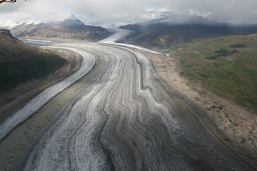
Glaciers
cover 25% of the park, with Hubbard Glacier (76 miles long, North
America’s largest tidewater glacier) and Bering Glacier (118 miles long,
the longest in North America) as standouts.
Rivers like the Copper,
Chitina, and Nabesna carve deep valleys, supporting salmon runs and
human travel corridors.
Access Points: The park has only two unpaved
roads: the 42-mile Nabesna Road in the north and the 60-mile McCarthy
Road in the south, leading to the historic towns of McCarthy and
Kennecott. Most of the park is accessible only by bush plane, boat, or
foot, emphasizing its wilderness character.
Geology
Wrangell–St. Elias is a geological showcase, shaped by tectonic
collisions, volcanism, and glaciation over millions of years.
Tectonic Setting:
The park lies at the convergence of the Pacific and
North American plates, where subduction and strike-slip faulting drive
mountain-building. The St. Elias Mountains formed as the Yakutat
microplate collided with North America, creating extreme uplift (up to 1
inch per year).
The Wrangell Mountains are part of a volcanic arc
formed 26–10 million years ago, with Mount Wrangell still active (last
minor eruption in 1900). Intrusive granites and volcanic rocks dominate
the range.
Glacial Sculpting:
The park’s 5,000+ glaciers,
covering over 3 million acres, have carved U-shaped valleys, cirques,
and fjords. The Bagley Icefield feeds massive glaciers like Malaspina
and Bering, which deposit vast moraines and reshape coastal landscapes.
Glacial surges, where glaciers rapidly advance (e.g., Hubbard Glacier’s
periodic damming of Russell Fjord), are a dynamic feature.
Rock
Types:
The St. Elias range features metamorphic rocks (schist,
gneiss) and sedimentary layers uplifted from ancient ocean floors.
The Wrangell range includes volcanic rocks (basalt, andesite) and ash
deposits.
The Copper River Basin contains alluvial sediments from
glacial and riverine processes.
Fossils and Minerals:
While
not as fossil-rich as Badlands National Park, marine fossils in the St.
Elias range indicate its oceanic origins. The park’s copper deposits,
among the world’s richest, fueled the Kennecott mining boom (1900–1938).
Gold, silver, and other minerals are also present, though less
economically viable today.
Geohazards: The park is seismically
active, with frequent earthquakes along faults like the Denali and
Totschunda. Climate change accelerates glacial retreat, altering river
systems and coastal landscapes.
Wrangell–St. Elias encompasses diverse ecosystems, from coastal
rainforests to alpine tundra, supporting a wealth of flora and fauna
adapted to extreme conditions.
Flora:
Coastal Zone: Temperate
rainforests of Sitka spruce and western hemlock thrive in the wet, mild
climate near Icy Bay.
Interior Lowlands: Boreal forests of white
spruce, black spruce, and paper birch dominate the Copper River Basin,
with willow and alder in wetlands.
Alpine and Tundra Zones: Above
treeline (2,500–3,000 feet), alpine meadows and tundra feature dwarf
shrubs, lichens, and wildflowers like mountain avens and arctic lupine.
Glacial silt and harsh soils limit vegetation in many areas, but
nutrient-rich river valleys support lush growth.
Fauna:
Mammals: The park hosts grizzly and black bears, moose, Dall sheep,
mountain goats, caribou, wolves, lynx, and wolverines. Coastal areas
support sea otters and harbor seals.
Birds: Over 200 bird species,
including bald eagles, trumpeter swans, and peregrine falcons, migrate
or nest here. The Copper River Delta, just outside the park, is a
critical stopover for millions of shorebirds.
Fish: Salmon (sockeye,
coho, chinook) spawn in rivers, sustaining wildlife and human
communities. Trout and grayling inhabit lakes and streams.
Conservation: The park’s intact ecosystems support stable populations of
large mammals, unlike fragmented habitats elsewhere. Black bear
populations, however, face pressures from human activity near McCarthy.
Environmental Challenges:
Climate change drives rapid glacial
retreat (e.g., Malaspina Glacier has thinned significantly), altering
hydrology and habitats.
Invasive species, like white sweetclover,
threaten native plants. Mining legacies (e.g., Kennecott’s tailings)
pose localized pollution risks.
The park’s remoteness aids
conservation, but warming temperatures increase wildfire risks in boreal
forests.
Climate:
The park spans multiple climate zones:
coastal areas are wet (100–200 inches of precipitation annually) and
mild (20–60°F), while interior regions are drier (10–20 inches) with
extreme temperatures (-50°F in winter, 80°F in summer).
High
elevations receive heavy snowfall, feeding glaciers and perennial
snowfields.
Wrangell–St. Elias has a rich human history, from Indigenous
stewardship to industrial mining and modern conservation.
Indigenous History:
The Ahtna, Tlingit, Upper Tanana, and Eyak
peoples have inhabited the region for at least 10,000 years, relying on
salmon, game, and trade networks. The Ahtna, centered in the Copper
River Basin, used copper for tools and ornaments, naming the river
Atna’tuu (“copper river”).
Indigenous place names, like Chitistone
(“stone heart”), reflect deep cultural ties. The park’s rivers and
passes were trade routes connecting coastal and interior tribes.
Today, Ahtna and other tribes maintain subsistence rights under ANILCA,
fishing, hunting, and gathering within the park. Cultural sites,
including fish weirs and village remnants, are protected but sensitive
to disturbance.
European and American Exploration:
Russian
explorers, including Vitus Bering, mapped the coast in the 1740s, naming
Mount St. Elias. The Russian-American Company traded with Tlingit
communities but focused on coastal Alaska.
After the U.S. purchased
Alaska in 1867, American prospectors explored the interior. The
1898–1899 Klondike Gold Rush brought attention to the region, though
Wrangell–St. Elias saw less activity than the Yukon.
Early climbers,
like the 1897 Italian expedition led by Prince Luigi Amedeo to summit
Mount St. Elias, marked the start of mountaineering in the park.
Mining Era (1900–1938):
The discovery of massive copper deposits in
1900 led to the Kennecott Copper Mine, a National Historic Landmark
within the park. The mine, operational until 1938, produced 591,535 tons
of copper and 9 million ounces of silver, worth over $1 billion in
today’s dollars.
The company town of Kennecott and nearby McCarthy
thrived, with the Copper River and Northwestern Railway (CR&NW) linking
the mine to Cordova. The railway’s construction, crossing glaciers and
rivers, was an engineering feat.
Mining left environmental scars,
including tailings and abandoned infrastructure, but Kennecott’s
preserved buildings (e.g., the 14-story concentration mill) draw
visitors today.
Park Establishment:
Conservation efforts began
in the 1920s, with proposals for a national park. ANILCA (1980)
established Wrangell–St. Elias as a park and preserve, balancing
wilderness protection with subsistence and limited sport hunting in the
preserve portion.
Its designation as a UNESCO World Heritage Site
(1979, with Kluane) recognizes its global geological and ecological
significance.
Wrangell–St. Elias offers unparalleled wilderness adventures, from
mountaineering to backcountry hiking, though its remoteness requires
preparation. The park is open year-round, with a $10 entrance fee (often
waived due to limited staffed entrances).
Scenic Drives:
McCarthy Road: A 60-mile gravel road from Chitina to McCarthy, following
the old CR&NW railway bed. It offers views of the Wrangell Mountains,
glaciers, and wetlands but requires caution due to rough conditions and
railway spikes.
Nabesna Road: A 42-mile road from Slana to Nabesna,
accessing the northern park. It features views of Mount Wrangell and
opportunities for hiking and wildlife viewing. High-clearance vehicles
are recommended.
Hiking and Backpacking:
Trails are limited
near roads, but the park’s vast backcountry is a hiker’s paradise.
Popular routes include:
Root Glacier Trail (4 miles round-trip,
moderate): From Kennecott, this trail leads to the Root Glacier’s white
ice, with options to join guided ice-climbing tours.
Bonanza Mine
Trail (9 miles round-trip, strenuous): A steep climb from Kennecott to
historic mine ruins, with views of Root and Kennicott Glaciers.
Skookum Volcano Trail (5 miles round-trip, moderate): Off Nabesna Road,
this trail crosses volcanic terrain with ash fields and tundra.
Backcountry routes, like the Goat Trail or Donoho Peak, require
navigation skills and permits (free, available at visitor centers).
Hikers must be bear-aware and prepared for river crossings.
Mountaineering and Climbing:
The St. Elias and Wrangell ranges are a
global mountaineering destination. Mount St. Elias, Mount Blackburn, and
Mount Sanford are challenging, multi-week expeditions requiring
technical skills and logistics (often via bush plane).
Easier peaks,
like Mount Donoho, offer non-technical climbs. Guided expeditions are
available from outfitters in McCarthy.
Glacier Tours and Ice
Climbing:
Guided tours on Root and Kennicott Glaciers include day
hikes, ice climbing, and multi-day treks. Outfitters provide crampons
and training for beginners.
Flightseeing tours by bush plane offer
aerial views of glaciers like Hubbard and Malaspina, often landing on
remote icefields.
Wildlife Viewing:
Moose, bears, and Dall
sheep are common along roads and trails. The Copper River Basin and
coastal areas are prime for birdwatching. Guided rafting trips on the
Chitina or Copper River increase wildlife sightings.
Rafting and
Kayaking:
The Copper, Chitina, and Kennicott rivers offer Class II–IV
rapids for experienced rafters. Coastal kayaking in Icy Bay provides
glacier and marine wildlife views. Permits and guides are recommended.
Camping:
Developed Campgrounds: Limited to small sites near
McCarthy and Nabesna (e.g., Kendesnii Campground). Fees are minimal or
free.
Backcountry Camping: Allowed park-wide with no designated
sites. Campers must follow Leave No Trace principles, store food
securely, and obtain permits for extended trips.
Winter camping is
possible but requires extreme cold-weather gear.
Flightseeing and
Air Taxis:
Bush planes from McCarthy, Gulkana, or Glennallen provide
access to remote areas, including drop-offs for climbers and
backpackers. Scenic flights over the Bagley Icefield or Mount St. Elias
are popular.
Cultural and Historical Tours:
Guided tours of
Kennecott’s mine buildings, offered by the National Park Service or
private operators, explore the mining era. McCarthy’s museums and
historic structures provide context.
Indigenous-led tours, when
available, highlight Ahtna and Tlingit heritage.
Winter
Activities:
Cross-country skiing, snowshoeing, and snowmobiling are
possible along Nabesna and McCarthy roads (weather permitting). Aurora
viewing is spectacular in winter, though access is limited.
Access: The park is remote, with no public transportation. Visitors
drive via the Glenn Highway (to Nabesna) or Richardson/Edgerton Highways
(to McCarthy). Anchorage (250–300 miles) is the nearest major airport.
Bush planes serve McCarthy and remote airstrips.
Visitor Centers:
Wrangell–St. Elias Visitor Center (Copper Center, Mile 106.8 Richardson
Highway): Open year-round (seasonal hours), with exhibits, films, and
ranger programs on geology, wildlife, and culture.
Kennecott Visitor
Center (Kennecott, seasonal): Offers mine tours, maps, and permits.
Slana Ranger Station (Nabesna Road, seasonal): Provides backcountry
information and permits.
Best Times to Visit: Summer (June–August)
offers mild weather (50–70°F), long daylight, and accessible roads,
though mosquitoes are intense. Spring (April–May) and fall (September)
provide fewer crowds and vibrant colors but colder temperatures. Winter
(October–March) is harsh, with limited access but ideal for aurora
viewing.
Amenities: McCarthy and Kennecott offer lodging (e.g., Ma
Johnson’s Hotel), dining, and outfitters. No gas or groceries are
available in the park; stock up in Glennallen or Chitina. Cell service
and Wi-Fi are unreliable.
Safety: Visitors must be self-sufficient,
carrying water, food, bear-proof containers, and navigation tools.
Weather changes rapidly, and rivers can flood. Bear encounters are
common; carry bear spray and make noise while hiking. Backcountry
travelers should register with rangers.