Location: Copper Center, Alaska Map
Area: 13,175,901 acres (53,321 km²)
Official site
Fees and ermits
There are no entrance
stations or required fees to enter Wrangell-St. Elias National Park.
Wrangell – St. Elias National Park is located in Copper Center, Alaska in USA. Wrangell – St. Elias National Park covers an area of 13,175,901 acres (53,321 km²), the largest of all national parks (larger than countries such as Slovakia, Bosnia and Herzegovina or Costa Rica). Protects the area of Mount San Elías (5 489 m), the second highest peak in the country. The park is located on the border with Canada and borders another national park, the Canadian Kluane National Park. It is accessible by highway from Anchorage and two gravel roads (the McCarthy Road and the Nabesna Road) run through the park, making much of the interior accessible for mountaineering and camping. There are also charter flights in the park. The Wrangell-San Elías park received 61,085 visitors in 2007 and is rapidly gaining popularity thanks to the combination of size, distance and accessibility.
The area of Wrangell – St. Elias National Park was first protected by its proclamation on December 1, 1978 as a national monument of the United States, forming part of a group of 15 natural areas of Alaska Jimmy Carter, making use of the presidential prerogative granted by the law of Antiquities of 1906, proclaimed new national monuments, after the Congress of the United States had postponed a large purchase of Alaskan lands that had strong state opposition.
1
Wrangell-St. Elias National Park Visitor Center, Mile 106 Richardson
Highway, Copper Center, ☎ +1 907-822-5234. All Year: M-F 8AM-4:30PM.
Memorial Day-Labor Day: Daily 8AM-6PM. The Headquarters and Visitor
Center provides information about the entire park in addition to the
administration and management facilities. This new facility between
Glennallen and Copper Center. Movie theater, exhibits, and a short
nature trail to a spectacular view of the Wrangell Mountains. Park
rangers provide guided talks and walks daily during the summer
months. Subsistence fishing and hunt permits are also available.
Services available in nearby Copper Center include a post office,
lodging, gas station, food store, tire repair, and telephone.
2
Slana Ranger Station, Mile 0.5 Nabesna Road, ☎ +1 907-822-7401.
Summer: 8AM-5PM; Winter: Open, but call ahead. The Slana Visitor
Contact Station provides information about the northern side of the
park and the Nabesna Road. ATV permits, and subsistence permits are
also issued here. Bookstore, phone, restrooms, maps, and park film
shown on TV by request. Guided ranger interpretive programs
available.
3 Kennecott Visitor Center, in the historic train
depot building within the Kennecott Mill Town, ☎ +1 907-960-1027.
Memorial Day through Labor Day 9AM-5:30PM. Information hub for the
Kennecott Mines National Historic Landmark in the heart of
Wrangell-St. Elias National Park and Preserve. Pick up maps and
brochures, join a ranger for a history talk or nature walk, or plan
your wilderness excursion. The visitor center also hosts a small
branch of the Alaska Natural History Association's bookstore.
4
The McCarthy Road Information Station, mile 59 McCarthy Road. Open
Memorial Day to Labor Day 9:30AM-5PM. The information gateway to the
communities of McCarthy and Kennecott. As you arrive in McCarthy
stop by to get the latest information on parking, shuttle service
and park and community events. Rangers are also available to help
plan backcountry trips and answer questions. Restrooms and day-use
parking are available at this site. Overnight parking and camping
can be found at a variety of local private companies.
5 Chitina
Ranger Station, Chitina, ☎ +1 907-823-2205. Summer Only: Staffed
with assistance from the Chitina Chamber of Commerce Th-M 2PM-6PM.
Historic log cabin. Explore the exhibits and watch the 22-minute
park movie. Services available in Chitina include a post office, gas
station, store, tire repair, cafe and payphone. The log cabin
station is decorated with historic photographs featuring the town of
Chitina as a transportation hub, "where the rails meet the trails."
Trains, stagecoaches, dog sleds, and steamboats all passed through
Chitina on their way to the mining and commerce centers of Alaska
during Chitina's boom years, 1910-1938.
6 Dry Bay Ranger
Station, Yakutat, ☎ +1 907-784-3295. 8:30AM-4:30PM all year. This
Ranger Station and Visitor Center serves both Wrangell-St. Elias and
Glacier Bay National Park. Exhibits, information, park video,
bookstore, and trip planning. Located at the base of the St. Elias
Mountains, the city of Yakutat (pop. 633) is a Tlingit settlement on
the Gulf of Alaska. Outdoor guide services and commercial fishing
are the primary sources of income for most residents. Yakutat is
approximately 220 air miles northwest of Juneau, 218 air miles
southeast of Cordova and 342 air miles southeast of Anchorage.
Unlike most other national parks in Alaska, Wrangell-St. Elias
National Park has relatively good road access, although there are only
two short stretches of road within the park itself. The nearest
international airport is in Anchorage. The national park can be reached
by road in about four hours via the Glenn Highway. At Glennallen, where
the national park's main visitor center is located a little south, the
Glenn Highway merges into the Richardson Highway and continues south to
Valdez, where larger car ferries via the Alaska Marine Highway also
dock.
There are only two gravel roads within the boundaries of
the national park, although some car rental companies prohibit driving
on these roads. One (McCarthy Road) runs 98 km from Chitina on the west
side of the park along the Chitina River to McCarthy, the other (Nabesna
Road) runs 73 km from Slana in the north to Nabesna.
Within the park is Kennicott, an abandoned mining settlement for five
copper mines nearby. Kennecott Copper Corporation began construction of
the mine in 1908, which began operating in 1911 and quickly attracted
large numbers of workers. In 1938 the last mines were shut down. From
there, the copper mined in this way was transported via McCarthy to
Cordova on the Gulf of Alaska via the Copper River and Northwestern
Railway. McCarthy became a ghost town after the copper mines were shut
down and the railroad stopped. Only in the 1970s, when the region around
Kennicott was developed for tourism, did people settle again. The ruins
of the Kennicott mines survive to this day and are on the National
Register of Historic Places. In addition to copper mining, gold was also
mined at Nabesna in the north.
Established in 1980 by the Alaska
National Interest Lands Conservation Act, the national park is almost
six times the size of Yellowstone National Park. Three different
protection zones have been designated within the park; part is
designated as a National Preserve, where the level of protection is
lowest. Here, mining or hunting is permitted both as a traditional use
of the indigenous people, as well as for non-residents and commercially.
Mining continues today on a small scale in private parts of the National
Preserve. The 36,732.3 km² Wrangell-Saint Elias Wilderness is designated
a Wilderness Area, the strictest class of protected area in the United
States. It is the core zone of the national park and at the same time
the largest wilderness area in the USA, accounting for ten percent of
the entire National Wilderness Preservation System.
Together with
Canada's Kluane National Park in the Yukon Territory, Glacier Bay
National Park & Preserve in extreme southeast Alaska on the Gulf of
Alaska and Tatshenshini-Alsek Provincial Park in British Columbia
(Canada), the park has been a UNESCO World Heritage Site since 1994 .
With a total area of 97,124 km², this protected area is one of the
largest in the world.
9 of the 16 highest mountains in the United States are in
Wrangell-St. Elias National Park. Most of the mountains in the Wrangell
Mountains, including Mount Wrangell, which last erupted in 1930 and is
4,316 m high, meet the world's highest coastal mountain range, the Saint
Elias Mountains, with the highest point in the park, Mount Saint Elias
(5,489 m) on the Gulf of Alaska. . In addition, the Chugach Mountains in
the southwest and foothills of the Alaskan chain in the north (with the
Nutzotin and Mentasta Mountains) meet here. The latter represent the
northern boundary of the park, while to the west the park boundary runs
along the Copper River.
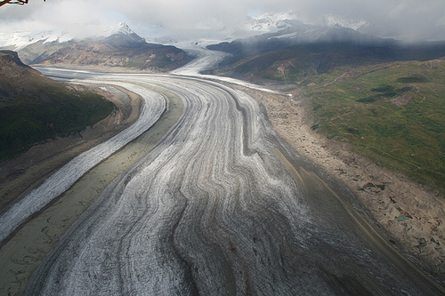
There are countless glaciers within the
boundaries of the national park. The Bagley Icefield is North America's
largest sub-polar ice field in the Chugach Mountains. It feeds numerous
large glaciers such as the Malaspina Glacier, the Hubbard Glacier or the
Bering Glacier, which, with an area of 5200 km² and a length of 190 km,
is both the largest and longest glacier in North America.
Wolves, mountain goats, black bears, grizzly bears, elk and caribou are among the rich, large animal world of this vast wilderness untouched by civilization. In addition, one of the largest populations of Dall sheep live here (approx. 13,000 animals) and two reintroduced herds of bison. The puma may also be found in the park. Incidentally, Canada lynx, coyote and wolverine are the main predators in the area, along with bears and wolves. Smaller mammals of the national park are red fox, North American otter, beaver, urson, hoary marmot, snowshoe hare, arctic ground squirrel, flying squirrel, red squirrel, pika and various small rodents such as lemmings. Whales, sea otters, seals and sea lions live in the coastal waters. About 80 percent of the land area consists of snow, ice and rocks. Due to the harsh climate, apart from the extensive spruce forests in the lower elevations, mainly dwarf shrubs and grasses occur, but there is a great variety of species. Typical shrubs are the blueberry and the needle rose.