Location: Rapid City Map
Area: 244,000 acres
Official site
Badlands National Park, located in southwestern South Dakota, is a striking and otherworldly landscape defined by its rugged terrain, vibrant geological formations, rich fossil beds, and expansive mixed-grass prairie. Covering 242,756 acres (379.3 square miles), the park protects sharply eroded buttes, pinnacles, spires, and canyons alongside the largest undisturbed mixed-grass prairie in the United States. Known as Makȟóšiča ("bad lands") to the Lakota people and les mauvaises terres pour traverser ("bad lands to travel through") to French trappers, the park’s harsh environment and dramatic beauty draw nearly one million visitors annually.
An entry pass good for one year is available for
$30. Otherwise, people who drive a non-commercial vehicle can buy a
7-day pass for $15. Hikers, cyclists and motorcyclists can get a
7-day pass for $10.
Members of the Oglala Sioux tribe can buy
the 7-day pass at half price.
There are several passes for
groups traveling together in a private vehicle or individuals on
foot or on bike. These passes provide free entry at national parks
and national wildlife refuges, and also cover standard amenity fees
at national forests and grasslands, and at lands managed by the
Bureau of Land Management and Bureau of Reclamation. These passes
are valid at all national parks including Badlands National Park:
The $80 Annual Pass (valid for twelve months from date of issue)
can be purchased by anyone. Military personnel can obtain a free
annual pass in person at a federal recreation site by showing a
Common Access Card (CAC) or Military ID.
U.S. citizens or
permanent residents age 62 or over can obtain a Senior Pass (valid
for the life of the holder) in person at a federal recreation site
for $80, or through the mail for $90; applicants must provide
documentation of citizenship and age. This pass also provides a
fifty percent discount on some park amenities. Seniors can also
obtain a $20 annual pass.
U.S. citizens or permanent residents
with permanent disabilities can obtain an Access Pass (valid for the
life of the holder) in person at a federal recreation site at no
charge, or through the mail for $10; applicants must provide
documentation of citizenship and permanent disability. This pass
also provides a fifty percent discount on some park amenities.
Individuals who have volunteered 250 or more hours with federal
agencies that participate in the Interagency Pass Program can
receive a free Volunteer Pass.
4th graders can receive an Annual
4th Grade Pass that allows free entry for the duration of the 4th
grade school year (September-August) to the bearer and any
accompanying passengers in a private non-commercial vehicle.
Registration at the Every Kid in a Park website is required.
In
2018 the National Park Service will offer four days on which entry
is free for all national parks: January 15 (Martin Luther King Jr.
Day), April 21 (1st Day of NPS Week), September 22 (National Public
Lands Day), and November 11 (Veterans Day weekend).
Badlands National Park is situated in Oglala Lakota, Pennington, and
Jackson counties, approximately 50–75 miles east of Rapid City, South
Dakota, and near the Black Hills. The park is divided into three main
units:
North Unit: The most accessible and visited section,
containing the park headquarters, Ben Reifel Visitor Center, and the
27-mile Badlands Loop Road (Highway 240). This unit features the iconic
Badlands Wall, an 80-mile-long ridge of eroded sedimentary rock forming
a natural barrier between the higher northern prairies and lower
southern bottomlands. The Badlands Wilderness, a 64,144-acre designated
wilderness area, lies within this unit.
Stronghold Unit (South Unit):
Located within the Pine Ridge Indian Reservation and co-managed with the
Oglala Lakota tribe, this unit includes Stronghold Table, a site of
1890s Ghost Dances, and Red Shirt Table, the park’s highest point at
3,340 feet. It has fewer services and is less visited, offering a more
remote experience.
Palmer Creek Unit: Also within the Pine Ridge
Reservation, this smaller, remote area is largely inaccessible to casual
visitors due to limited infrastructure.
The park lies in a semi-arid
high-plains region between the Cheyenne and White rivers. The northern
grasslands, drained by Cheyenne River tributaries, sit 200 feet higher
than the southern bottomlands, drained by White River tributaries. The
Badlands Wall, sculpted by water and wind erosion, creates a maze of
gullies, ridges, and spires, giving the park its signature “badlands”
appearance.
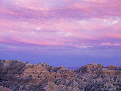
The park’s surreal landscape is a product of 75 million years of
geological processes, primarily deposition and erosion, which have
carved a “layer cake” of sedimentary rock formations.
Formation
Timeline:
Late Cretaceous Period (~75 million years ago): The region
was part of a shallow inland sea, depositing the Pierre Shale, the
park’s oldest layer, which later crumbled into the mustard-colored
Yellow Mounds Formation.
Eocene Epoch (~37–34 million years ago):
Subtropical forests covered the area, and river floodplains formed the
Chadron Formation, consisting of mud rocks.
Oligocene Epoch (~34–28
million years ago): As the climate cooled and dried, savannahs replaced
forests, creating the Brule Formation (gray stream and floodplain
deposits) and the Sharps Formation (volcanic ash, sandstone, and
floodplain mud). These upper layers form the park’s youngest rocks.
Erosion (~500,000 years ago–present): The Cheyenne River captured
streams from the Black Hills, initiating rapid erosion of soft
sedimentary layers. Wind, water, and ice continue to erode the Badlands
at a rate of about 1 inch per year, compared to the Black Hills’ slower
1 inch per 10,000 years.
Key Features: The park’s landscape is
characterized by multicolored rock layers—tan, brown, gray, yellow, and
black—formed by varying sediment types (sand, silt, clay, and volcanic
ash). Notable formations include jagged buttes, spires, pinnacles, deep
canyons, and ravines. The Badlands Loop Road offers scenic overlooks
like Big Badlands Overlook, showcasing these vibrant, striped layers.
Fossil Beds: The park contains some of the world’s richest fossil beds,
particularly from the Oligocene Epoch (33.7–23.8 million years ago).
Fossils of ancient mammals—three-toed horses, camels, saber-toothed
cats, rhinos, and oreodonts (sheep-like mammals)—are abundant. The
Fossil Exhibit Trail features replicas of these creatures, and the Ben
Reifel Visitor Center’s fossil preparation lab allows visitors to
observe paleontologists at work.
Badlands National Park protects a diverse mixedGrass prairie
ecosystem, one of the largest in the U.S., supporting over 400 plant
species and a variety of wildlife.
Flora:
The mixed-grass
prairie, a transition between tall-grass prairies to the east and
short-grass prairies to the west, thrives in a semi-arid climate with
unpredictable rainfall, periodic floods, droughts, and wildfires. Common
grasses include western wheatgrass, a native perennial. Sparse trees
like Rocky Mountain juniper and Great Plains cottonwood dot the
landscape.
Rare and endemic plants include Barr’s milkvetch and
Dakota buckwheat, while invasive species like Japanese brome, Kentucky
bluegrass, and yellow sweetclover pose challenges.
The park’s thin
topsoil and frequent wildfires limit vegetation on eroded formations,
creating a stark contrast between barren badlands and grassy prairies.
Fauna:
Mammals: The park is home to American bison (~1,200
individuals, reintroduced in 1963), bighorn sheep, pronghorn antelope,
mule deer, coyotes, jackrabbits, and the endangered black-footed ferret,
reintroduced to the Badlands Wilderness. Prairie dog towns are a
highlight, with black-tailed prairie dogs creating extensive tunnel
networks.
Other Wildlife: The park hosts 39 mammal species, various
reptiles (including rattlesnakes), amphibians, 69 butterfly species, and
numerous birds, such as western meadowlarks.
Conservation: Bison,
once numbering 30 million across the West, were nearly extinct by the
early 20th century due to overhunting. The park’s bison population is
managed by the National Bison Conservation Initiative, involving the
USGS and other agencies. The black-footed ferret’s reintroduction is a
key conservation success.
Environmental Challenges: Climate change,
invasive species, altered fire patterns, and grazing pressures threaten
the ecosystem. The park’s semi-arid climate, with hot, dry summers (up
to 114°F) and cold winters (below 40°F, with up to 2 feet of snow), adds
stress to flora and fauna.
The Badlands have a rich human history, from Indigenous stewardship
to modern conservation efforts.
Indigenous History:
The Lakota
people have lived and hunted in the region for at least 11,000 years,
using the Badlands’ cliffs as buffalo jumps to stampede bison to their
deaths. They found fossilized bones, seashells, and turtle shells,
correctly deducing the area was once underwater.
The Badlands held
spiritual significance, with the Stronghold Unit’s Stronghold Table
serving as a site for one of the last known Ghost Dances in 1890, a
resistance movement led by the prophet Wovoka. The dance aimed to
restore Indigenous lands and ways of life. The nearby Wounded Knee
Massacre (December 1890), 45 miles south of the park, marked the last
major clash between Plains Indians and the U.S. military until the
1970s.
Today, the Oglala Lakota co-manage the South Unit, and the
park recognizes its cultural importance to associated tribes.
European and American History:
French-Canadian fur trappers in the
19th century named the region for its difficult terrain. By the late
1800s, the Great Sioux Nation, including the Oglala Lakota, dominated
the northern prairie until homesteaders arrived, converting prairie for
farming and ranching.
Paleontological exploration began in the 1840s,
with Dr. Hiram Prout’s 1846 paper on a fossil jaw sparking interest. By
1854, 84 distinct fossil species were identified in the White River
Badlands, 77 from the park’s area. Yale professor O.C. Marsh refined
fossil extraction methods in the 1870s, and the South Dakota School of
Mines remains active in research today.
Homesteading peaked in the
early 20th century, but the 160-acre plots (later increased to 640
acres) were insufficient in the semi-arid environment. The Great Dust
Bowl and grasshopper plagues of the 1930s drove many settlers away.
During World War II, the U.S. Air Force used parts of the South Unit as
a bomb and gunnery range, leaving remnants still visible.
Park
Establishment:
Proposed in 1909, the Badlands were authorized as a
national monument in 1929 and designated a national park in 1978 to
protect its geological, paleontological, and ecological resources. The
park’s boundaries expanded to include surrounding grasslands, preserving
a rare intact section of the Great Plains.
Badlands National Park offers diverse activities for visitors, from
scenic drives to hiking and stargazing, accessible year-round (24/7)
with entrance fees of $15 (individual) to $30 (vehicle), valid for seven
days.
Scenic Drives:
Badlands Loop Road (Highway 240): This
27-mile loop through the North Unit features nearly 30 scenic overlooks,
including Big Badlands Overlook, Pinnacles Overlook, and Yellow Mounds
Overlook. It’s ideal for photography, especially at sunrise or sunset
when rock layers glow vibrantly.
Sage Creek Rim Road: A gravel road
off the western end of the Loop Road, offering wildlife viewing (bison,
prairie dogs) and access to the Sage Creek Wilderness Area.
Hiking:
The park’s trails, mostly in the North Unit near the Ben
Reifel Visitor Center, range from easy to strenuous. Popular trails
include:
Fossil Exhibit Trail (0.25 miles, easy): An accessible
boardwalk with fossil replicas and educational posts about prehistoric
animals.
Door Trail (0.75 miles, easy): A short hike through a “door”
in the Badlands Wall to a view of eroded formations.
Notch Trail (1.5
miles, moderate): A scenic trail with a log ladder climb, offering White
River Valley views (rattlesnake caution advised).
Castle Trail (4
miles, moderate): A strenuous prairie trail with valley and rock
formation views.
Hikers should carry water, wear layers, and watch
for rattlesnakes and cacti.
Wildlife Viewing:
Visitors can
spot bison, bighorn sheep, pronghorns, and prairie dogs along the Loop
Road and Sage Creek Rim Road. Roberts Prairie Dog Town is a prime
viewing spot. Binoculars enhance birdwatching.
Stargazing:
The
park’s isolation and clear skies make it ideal for stargazing. From
Memorial Day to Labor Day, ranger-led Night Sky Programs at the Cedar
Pass Campground amphitheater (9:15–9:45 p.m.) offer telescope viewing of
constellations, planets, and occasionally the International Space
Station. The annual Badlands Astronomy Festival attracts amateur and
expert astronomers.
Ranger Programs:
Seasonal programs (daily
in summer) include guided walks, fossil talks, geology discussions, and
Junior Ranger activities. Check the Ben Reifel Visitor Center for
schedules.
Camping:
Cedar Pass Campground: Offers 96 sites
with amenities (open seasonally).
Sage Creek Campground: A primitive,
free campground for backcountry camping, popular for bison sightings.
Reservations are recommended, and winter camping is limited due to
closures.
Bicycling: Bicycles are allowed on park roads, with the
Loop Road popular for its scenic views. Resources are available at the
visitor center.
Access: The park is accessible via Interstate 90, with entrances at
Pinnacles (Exit 110), Northeast (Exit 131), and Interior. Rapid City
Regional Airport (60 miles west) is the closest major airport. No public
transportation serves the park, but private bus tours from Rapid City
are available.
Visitor Centers:
Ben Reifel Visitor Center (North
Unit, Highway 240): Open year-round (except major holidays like
Christmas), with exhibits, a fossil lab, a bookstore, and an
informational video.
White River Visitor Center (South Unit, BIA 27):
Open seasonally (Memorial Day to mid-October), offering information on
the Stronghold Unit and Oglala Lakota history.
Best Times to Visit:
Spring (April–May) and fall (September–October) offer mild weather,
avoiding summer heat (up to 114°F) and winter snow (up to 2 feet). June
is the greenest but wettest month. Summer is busiest, though the park’s
vastness prevents crowding.
Amenities: Cedar Pass Lodge provides
dining (Sioux Indian Tacos, snacks) and lodging. No gas is available in
the park; fuel up in Wall or Interior. Cell service is spotty, and water
is scarce along trails.
Safety: Visitors should bring water,
sunscreen, insect repellent, and layers for fluctuating weather. Respect
wildlife, stay on trails, and monitor road conditions, especially in the
South Unit.