Location: Minnesota Map
Area: 1,090,000 acres (4,410 km²)
Info: (800) 777 7281
(218) 626 4300
Fees and permits
Camping permits and fees (both
U.S. and Canadian trips): camping permits, which control your entry
date and location must be reserved for your party. The Forest
Service fee for each permit issued is $12. You will also be required
to pay a USFS User Fee of $16 per adult and $5 per youth per trip.
Plan as much in advance as possible as the number of entries is
restricted. Canada requires a Remote Area Border Crossing form to be
applied for before you go. The cost is 30 Canadian dollars per
application. It takes about a month to get it, so make sure you plan
accordingly. The permit is good for 1 year.
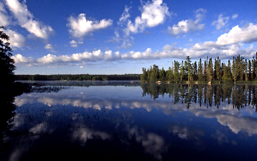
Boundary Waters Canoe Area Wilderness lies southeast of Voyageurs National Park in the state of Minnesota, USA. Covering an area of over one million acres, Boundary Waters Canoe Area Wilderness lies on the US- Canadian border. Canada’s Quetico Provincial Park lies on the other side of the border. Visitors come here for fishing, canoeing and camping. With over 1200 miles of canoe routes and more than 2000 lakes it has a lot to offer. Crappie, sunfish, catfish, small mouth bass, large mouth bass, lake trout, northern pike and many other species of fish live in Boundary Waters Canoe Area Wilderness. A permit for fishing and camping on thousands of sites in this wilderness is required. It can be baught in any local shop or on a gas station.
Unreserved campsites are available on most lakes in the BWCAW and are usually marked on area maps. They are generally close to the lakes (right on the shore) and provide a convenient place to store your canoes overnight. Rudimentary toilet facilities are usually located a short distance from the campsites and are generally marked by a path. There is a maximum size of groups in the Boundary Waters of 9 and no more that 4 watercraft.
The Boundary Waters Canoe Area Wilderness extends for
240 km along the U.S.-Canada border in the Arrowhead region of
Minnesota; the combined area of the BWCAW, Superior National Forest,
Voyageurs National Park, and Ontario's Ketchiko-Superior State Park and
La Verendrye State Park or simply the Boundary Waters, comprise a vast
area of contiguous wilderness lakes and forests. Lake Superior lies to
the south and east of the Boundary Waters.
Nearly 20% of the
total area of the BWCAW, or 190,000 acres (770 km2), is water area.
There are more than 1,100 lakes and hundreds of miles of rivers and
streams within the region's boundaries. The remaining 80% is forested;
the BWCAW is the largest remaining area of unlogged forest in the
eastern United States.
The Laurentian Divide, which separates the
Great Lakes watershed from the Hudson Bay watershed, runs
northeast-southwest through the eastern portion of the BWCAW along the
crest of the Superior Upland and Gunflint Mountains. Crossing the divide
at the height of the Land Portage was a ritual and initiation ceremony
for the fur-trading voyageurs of the 18th and early 19th centuries. The
wilderness area also contains Minnesota's highest peak, Eagle Mountain
(701 meters above sea level), which is part of the Missouri Hills.
There are six ranger stations in the vicinity of the BWCAW: Cook,
Aurora, Ely, Isabella, Tofte, and Grand Marais. The best visitor
services are located in Ely and Grand Marais. Historic roads such as the
Gunflint Trail, Echo Trail (County Road 116), and Fernberg Road (County
Road 18) lead to many wilderness entrances.