Location: Wisconsin Map
Length: 430 miles (692 km)
The Wisconsin River, a major tributary of the Mississippi River, is one of the most significant waterways in the Midwest, flowing approximately 420 miles (676 km) through Wisconsin. Known as the "Hardest Working River in the Nation" due to its extensive use for industry, hydropower, recreation, and agriculture, it is also Wisconsin’s longest river and a vital ecological and cultural lifeline. Below is an in-depth exploration of its geography, history, ecology, economic importance, cultural significance, and current challenges, with a focus on providing a comprehensive and nuanced understanding.
The Wisconsin River originates at Lac Vieux Desert, a
lake near the border of Wisconsin and Michigan’s Upper Peninsula, at an
elevation of about 1,683 feet (513 meters). From this headwater, it
flows southward through central and southern Wisconsin, joining the
Mississippi River at Prairie du Chien in Grant County. Its drainage
basin spans 12,280 square miles (31,805 km²), covering roughly one-third
of Wisconsin and parts of 23 counties.
The river is divided into
two distinct sections:
Upper Wisconsin River: From Lac Vieux Desert
to the Castle Rock Flowage, this section is characterized by a forested,
less developed landscape with rapids, waterfalls, and a steeper
gradient. It flows through the Northern Highland region, including areas
like the Wisconsin Dells.
Lower Wisconsin River: From Castle Rock
Flowage to the Mississippi, this section is wider, slower, and more
navigable, meandering through agricultural lowlands and urban areas like
Portage and Prairie du Chien.
Key tributaries include the Baraboo,
Kickapoo, Pine, and Eau Claire rivers, which contribute to its extensive
watershed. The river’s course features 26 hydroelectric dams, creating
flowages (reservoirs) like Lake Wisconsin and the Petenwell Flowage,
which regulate water flow but alter its natural state.
The Wisconsin River’s path was shaped by glacial
activity during the last Ice Age (Wisconsin Glaciation, ~80,000–10,000
years ago). The river’s upper reaches cut through Precambrian bedrock
and glacial moraines, forming rugged terrain, while the lower river
flows over sedimentary rock, creating broad floodplains. Notable
geological features include:
Wisconsin Dells: A 5-mile gorge with
sandstone formations carved by glacial meltwater, featuring cliffs up to
100 feet high. The Dells are a major tourist attraction, known for boat
tours and scenic beauty.
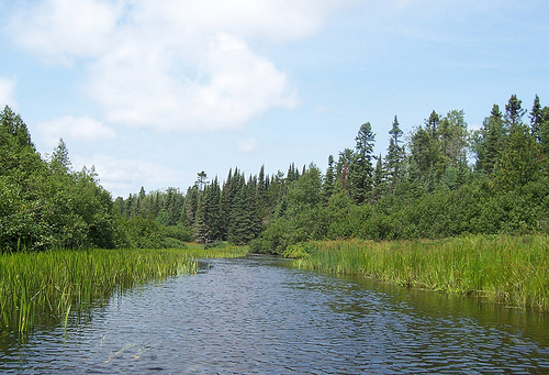
Sandbars and Islands: The lower river,
especially the Lower Wisconsin Riverway (a 92-mile free-flowing
stretch), is famous for its shifting sandbars and islands, ideal for
canoeing and camping.
Flowages: Dams like those at Petenwell and
Castle Rock create large reservoirs, with Petenwell Flowage being
Wisconsin’s second-largest lake (23,040 acres).
The river’s flow
varies significantly, from 1,000 cubic feet per second (cfs) in dry
periods to over 100,000 cfs during floods, influenced by snowmelt,
rainfall, and dam releases. Its gradient drops 1,023 feet from source to
mouth, with a steeper drop in the upper river.
The Wisconsin River has been central to human activity for
millennia, shaping Indigenous cultures, European exploration, and
industrial development.
Indigenous History
The river,
called Wiskonsan or Meskonsing (meaning “it lies red” or “place of
the beaver” in Algonquian languages), was home to Ho-Chunk,
Menominee, Ojibwe, and Sauk peoples. They used it for fishing,
transportation, and trade, with villages along its banks.
Archaeological sites, like those near the Baraboo River confluence,
reveal evidence of effigy mounds and fishing weirs. The river’s
cultural importance persists in Ho-Chunk oral traditions, which
describe it as a sacred lifeline.
European Exploration and
Settlement
French explorers Jean Nicolet (1634) and Jacques
Marquette and Louis Joliet (1673) traveled the Wisconsin River
during their expeditions, using it to connect the Great Lakes to the
Mississippi via the Fox-Wisconsin portage at modern-day Portage. The
river became a key fur trade route, with trading posts established
at places like Prairie du Chien. By the 19th century, European
settlers exploited the river for logging, leading to the rise of the
timber industry.
Industrial Era
In the mid-1800s, the
Wisconsin River was a hub for logging, with millions of board feet
of white pine floated downstream to sawmills in Wausau, Stevens
Point, and Wisconsin Rapids. The river’s rapids and falls powered
early sawmills and gristmills. By the late 19th and early 20th
centuries, hydroelectric dams and paper mills transformed the river
into an industrial powerhouse. Companies like Consolidated Papers
(now Verso Corporation) in Wisconsin Rapids relied on the river for
pulp production, earning the region the nickname “Paper Valley.”
The Wisconsin River supports a diverse ecosystem, though it faces environmental challenges from damming, pollution, and development.
The river’s watershed includes forests, wetlands, prairies, and
savannas, supporting:
Fish: Over 70 species, including walleye,
smallmouth bass, sturgeon, and muskellunge. The river is a critical
spawning ground, though dams impede migration.
Birds: Bald eagles,
herons, and migratory waterfowl thrive along the river, with the Lower
Wisconsin Riverway designated a key birding area.
Mammals: Beaver,
otter, and white-tailed deer are common, with occasional black bear
sightings in the upper river.
Plants: Riparian zones feature willows,
cottonwoods, and wild rice, while the Dells’ sandstone cliffs host
unique ferns and lichens.
The river’s flowages create wetland
habitats but disrupt natural riverine ecosystems, reducing native mussel
populations and altering sediment flow.
The Lower Wisconsin Riverway, established in 1989 as a
state-protected area, preserves 92 miles of free-flowing river from
Prairie du Sac to the Mississippi. Managed by the Wisconsin Department
of Natural Resources (DNR), it bans development and promotes recreation.
Other efforts include:
Dam removal and fish passage: Projects to
restore fish migration, like the removal of smaller dams on tributaries.
Water quality monitoring: The DNR and citizen groups track pollutants,
particularly mercury and phosphorus from agricultural runoff.
Invasive species control: Efforts target carp, zebra mussels, and
Eurasian milfoil, which threaten native species.
The Wisconsin River has long been an economic engine, though its uses
have evolved:
Hydropower: The 26 dams generate about 400
megawatts annually, powering communities and industries. Major dams
include Rhinelander, Wausau, and Prairie du Sac.
Industry: Paper and
pulp mills in Wisconsin Rapids and Stevens Point remain active, though
the industry has declined since the 1980s. The river also supports
agriculture, with irrigation for cranberry bogs in the central sands
region.
Tourism and Recreation: The river generates millions in
tourism revenue through fishing, boating, kayaking, and attractions like
the Wisconsin Dells, which draws over 4 million visitors annually. The
Lower Wisconsin Riverway is a premier canoeing destination, with
outfitters offering rentals and guided trips.
The Wisconsin River is woven into Wisconsin’s identity, celebrated in
art, literature, and community life. It inspired Aldo Leopold’s A Sand
County Almanac (1949), which describes the river’s ecological beauty
near his Sauk County farm. Festivals like the Wisconsin River Pro Rodeo
in Merrill and Riverfest in Wausau highlight its role in local culture.
Recreational activities include:
Boating and Canoeing: The Lower
Wisconsin Riverway is ideal for multi-day canoe trips, with public
access points and campsites on sandbars.
Fishing: The river is a top
destination for walleye and bass fishing, with tournaments like the
Wisconsin River Series.
Hiking and Birding: Trails like those at
Devil’s Lake State Park (near the Baraboo River confluence) offer river
views, while the Horicon Marsh, fed indirectly by the river, is a global
birding hotspot.
Winter Activities: Ice fishing and snowmobiling
occur on frozen flowages.
The Wisconsin Dells, dubbed the “Waterpark
Capital of the World,” combines natural beauty with amusement parks,
waterparks, and boat tours, making it a family-friendly destination.
The Wisconsin River faces several challenges:
Water Quality:
Agricultural runoff, industrial discharge, and legacy pollutants like
mercury impair water quality. The DNR lists parts of the river as
impaired under the Clean Water Act.
Dams and Habitat Fragmentation:
Aging dams disrupt fish migration and sediment flow, prompting debates
over removal versus modernization. The Petenwell and Castle Rock dams,
built in the 1940s, require costly repairs.
Climate Change: Increased
flooding (e.g., 2010 and 2018 floods) and drought cycles threaten
infrastructure and ecosystems. Warmer water temperatures stress
cold-water fish like trout.
Development Pressures: Urban sprawl and
second-home development near the river, especially in the Dells, strain
natural resources.
Future management hinges on balancing economic,
recreational, and ecological needs. Initiatives like the Wisconsin River
TMDL (Total Maximum Daily Load) plan aim to reduce nutrient pollution,
while community groups advocate for dam removals to restore free-flowing
sections. The Lower Wisconsin Riverway’s protected status ensures a
pristine stretch, but upstream areas need similar safeguards.
Sources like the Wisconsin DNR, Wisconsin Historical Society, and regional tourism boards provide detailed data but may downplay environmental issues to promote recreation or industry. The river’s nickname, “Hardest Working River,” romanticizes its industrial past while obscuring ecological costs, such as the loss of native mussels or fish populations due to damming. Indigenous perspectives, though acknowledged in historical accounts, are underrepresented in modern narratives, warranting further oral history research. The focus on tourism, particularly in the Dells, risks overshadowing the river’s broader ecological and cultural roles.