Location: Vermont and New York Map
120 miles long
12 miles wide
500 miles of shoreline
Lake Champlain is a long narrow body of water between Vermont and
New York states of USA. The lake covers an area of 1,269 sq km (490
sq mi) with a maximal depth of 122 metres (400 feet). First European
explorer to visit this area was French man Samuel de Champlain in
1609. With a growth of British presence in the region lake became an
important highway for trade in the region. Its unique position and
shape made it perfect for transport of goods and even armies.
Champlain Area Trails (CATS) is a network for hiking, walking,
skiing, snowshoeing, birding, tracking, and picnicking in and around
the Champlain Valley in New York State's Adirondack Park. CATS
trails encompass a rich tapestry of preserved wildlife habitats,
pastoral farmland, historic villages, scenic woodlands, and a
diverse aquatic system of streams, rivers, wetlands, ponds including
the Boquet River and Lake Champlain.
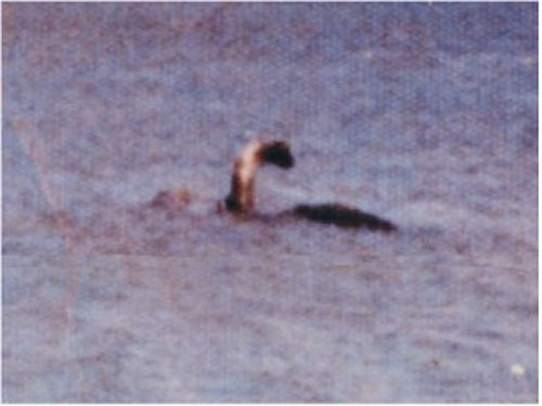
Most famous resident of Lake Champlain is an alleged water serpent known locally simply as Champ. The Iroquois and the Abenaki called this serpent "Tatoskok." Besides obvious similarities to Loch Ness Monster (aka Nessie) in Scotland the lake has many similar features as Loch Ness. It has a similar shape and similar biosphere that in theory could support a small population of ancient plesiosaur that could survive change of climate.
The first European traveler to describe his own encounter with a legendary animal was Samuel de Champlain for whom the lake is named. He described it as large aquatic animal that measured 5 feet (1.5 m). He was covered by silver grey scale that could withstand hit of the dagger. In addition the animal had a long neck that is as thick as human's thigh. Unfortunately the description is a dubious one since no first hand documents were discovered to support the account.
The first proven reference to the mystical New England creature comes in 1641 in An Account of Two Voyages to New England witten by John Josselyn in 1639.
"They told me [in 1639] of a sea serpent or snake, that lay quoiled up like a cable upon a rock at Cape Ann; a boat passing by with English[men] on board, and two Indians, they would have shot the serpent, but the Indians dissuaded them, saying that if he were not killed outright, they would all be in danger of their lives"
In August of 1817 a sea serpent was spotted off the shore in Gloucester Harbor. He stayed for almost a month in this location. Champ was first spotted on August 6th by two women who took a leisure walk along a tranquil lake. They saw a 60 foot long creature at the entrance to the harbor. On August 14th local resident Matthew Gaffney attempted to shoot the animal, but he either missed him or a thick scale saved the creature. In the next several days Champ was seen by Solomon Allen III, Amos Story with his wife and Lydia and Samuel Wonson. On August 18th the cryptid was seen at the Pavilion Beach by several people. These were all credible sources and couldn't be disproved. Subsequently first scientific attempt to explain these sightings was undertaken by New England Linnaen Society.
Many people flocked to Gloucester Harbor to see the creature. Colonel Thomas Handasyd Perkins was among these people. He was a rich businessman who later served as a congressman. He described this even. All the town was on the alert and almost every individual both great and small had been gratified with a sight of him". He further describes the creature that measured at least 40 feet long with a dark brown scales protecting his whole body. Champ quickly moved through the water with a vertical flexure of the spine. It is an interesting detail since only marine mammals swim with the an upstroke. Fish, reptiles and other creatures move their bodies horizontally as they swim.
New England Linnaen Society attempted to explain the creature as merely a deformed snake. They even dissected a specimen that was brought to them by one of the fishermen. The snake was only few feet long, but its back was covered in strange humps. Few people believed that this was the same monster they saw for almost a month in the Lake Champlain. Their doubts were further shaken then the next year a creature returned and was seen again by hundreds of onlookers in different locations along a lake. Another reference about the the creature came on July 24, 1819 in a Plattsburgh Republican. In a article under title "Cape Ann Serpent on Lake Champlain" it gave an account of Captain Crum who saw an enormous monster.
Champ become really famous after Sheriff Nathan H. Mooney described his encounter with an animal in 1883. He claimed he saw an aquatic animal 50 yards from a lake's shore. Law man approximated the length of the creature to 25- 30 feet in length with "round white spots inside its mouth". A craze for a mysterious cryptid took Eastern USA by storm. Many people flocked to the lake's shores with hopes to see a creature. Famous American show man P.T. Barnum even offered $50,000 for a corpse of an animal.
The sightings of the Lake Champlain monster continued through out a 20th and 21st centuries. Photographs and videos surface almost every year. Interestingly evidence for this secretive creature added by means of echolocation. The recording of a strange voice was made in 2003 by the scientists from the Fauna Communications Research Institute. They described the voice as similar to that of a whale or a dolphin. However it sounded different from any mammal they encountered. The mystery continues.
Lake Champlain Maritime Museum
4472 Basin Harbor Rd, Vergennes
Tel. (802) 475- 2022
Open: late May- mid- Oct: 10am- 5pm
www.lcmm.org
During the last ice age, about 20,000 years ago, the Lake Champlain
Basin and most of New England and New York State were covered in ice,
while Lake Vermont s was formed 12,500 years ago as a result of melting
glaciers. Finally, about 10,000 years ago, the Champlain Sea, at the
origin of the lake, took shape when the glaciers receded, thus allowing
the basin to be flooded by the waters of the St. Lawrence estuary.
Lake Champlain takes its name from the French explorer Samuel de
Champlain, who, after siding with the Algonquins against the Iroquois,
traveled up the Richelieu River rather than up the St. Lawrence River
towards Montreal as usual, to arrive to the lake and give it its name on
July 14, 1609.
In colonial times, the lake served as a
communication channel between the St. Lawrence and Hudson valleys,
summer and winter (on ice). In 1666 Fort Sainte-Anne was built by the
French on Isle La Motte. Important battles took place near its shores
(at Fort Carillon in 1758 and Fort Ticonderoga in 1777) or on its waters
(in 1776 at Île Valcour and in 1814 for the Battle of Plattsburgh).
Lake Champlain is a large lake that straddles the United States and
Canada. Its extent is mostly within the United States, forming the sixth
largest body of fresh water in the country. It is located in the Lake
Champlain Valley, on the border of the states of Vermont and New York,
its northern end being south of the province of Quebec. It is naturally
drained by the Richelieu River. The lake region is called Champlain
Valley by Americans.
To the east, the lake is bordered by the
Green Mountains, a branch of the Appalachians, as well as by the
mountains of the Taconic Valley, while to the west rise the Adirondacks.
An invisible border divides the lake between the state of Vermont to the
east and the state of New York to the west. This line of demarcation
follows the deep water channel which crosses the lake from one end to
the other in the direction of its length. Nearly two-thirds of the
lake's area is on the Vermont side. In addition, the lake is divided in
its north-south axis by the islands South Hero, North Hero and La Motte.
Its altitude is about thirty meters. The ports of Burlington, Port
Henry, and Plattsburgh, although they achieved some commercial
importance in the past, are now little used except by small ships,
ferries, and cruise ships.
Lake Champlain is the sixth largest body of fresh water in the United
States. Its 1,127 square km are home to more than 70 islands. Lake
Champlain contains 26 km3 of water and is used to supply drinking water
to nearly 200,000 people. The lake is made up of different main
stretches: the south lake, long and narrow; the main lake, the widest
and deepest section; Malletts Bay, surrounded by a historic railway and
road; the Inland Sea, which lies east of the Hero Islands, and
Missisquoi Bay, a large bay rich in wildlife. Thirty-one tributaries
drain the Lake Champlain watershed (8,234 square miles) and supply over
91% of the lake's water. The mouths of the deltas and associated
wetlands of these tributaries provide excellent conditions for canoeing
on the lake.
Lake Champlain can be divided into four distinct
zones. The shoreline is the littoral zone. This is the area where
sunlight penetrates to the bottom of the lake and submerged vegetation
can grow. Deeper waters can be divided into a limnetic zone and a deep
zone. The limnetic zone is the zone of open water, where sunlight can
penetrate, but not to the bottom. Here, algae dominate the base of the
food chain. The perpetually dark zone is below the limnetic zone, beyond
the reach of the sun's rays. The benthic zone is the deepest layer of
sediment that provides habitat for many organisms. They find their food
in the waste that sinks to the bottom over time.
Spring floods are common in Lake Champlain. For good reason, this
narrow lake is bordered by mountains which, when spring comes, release
large quantities of water: by streams and rivers, it flows directly into
the lake. In fact, ever since water levels were measured in this region,
which dates back to the 19th century, we know that the lake has
experienced several flooding episodes. On April 29, 2011, at Rouses
Point, the United States Weather Service recorded a level of 102.56
feet, up 0.4 feet (five inches) from the previous day. The flood exceeds
the record of 102.10 feet set in 1869.
These floods would be
caused by the heavy rains combined with the snowmelt which made the
rivers overflow.
In Quebec, at least 18 localities located along
the Richelieu were flooded between Lake Champlain and Beloeil. The
rising waters, caused by the heavy rains that fell on southern Quebec
and the northeastern United States for several days, caused the level of
the Richelieu River to rise by more than one meter on a distance of at
least 50 kilometers. The cities of Venise-en-Québec, Noyan,
Saint-Jean-sur-Richelieu, Henryville, Saint-Paul-de-l'Île-aux-Noix and
Sainte-Anne-de-Sabrevois are among the most affected by the floods. .
The premier of Quebec said it was probably the biggest disaster Quebec
has experienced since the Saguenay floods in 1996.
Since the 1980s, the water quality of Lake Champlain has improved.
Efforts by the state of New York and Vermont in the United States as
well as the province of Quebec, in Canada, have enabled the construction
of wastewater treatment plants. However, Lake Champlain is not immune to
pollution: phosphorus and chemicals from cities and farmlands continue
to pollute it. It must be said that many tributaries flow into it, fed
by rain and melting snow9.
Manure and fertilizer from adjacent
lands are the main sources of phosphorus pollution. A particularly high
presence of phosphorus in the water creates excessive growth of
blue-green algae. These release toxins that are harmful to humans and
animals while unbalancing entire ecosystems. To this is added occasional
wastewater from cities and industrial discharges. The lake cannot absorb
more than 110 metric tons of phosphorus per year. In 2009, there was a
rate of 218 metric tons.
If phosphorus is very present in the
water of Lake Champlain, so are the chemical products; contaminating
plants, animals and even humans. This pollution can lead in some cases
to health alerts on the consumption of certain species of fish for their
too high concentration of PCBs or mercury. Three areas of the lake are
particularly affected by chemical pollution: Cumberland Sound, the inner
Burlington Basin and the vicinity of Malletts Bay.
The PMVLC13
(Missisquoi Bay Basin Project) studied the different sources of toxic
substances in Lake Champlain, grouping them into four priority groups to
be treated according to their level of contamination. In the first group
are BCP and mercury. In the second, arsenic, cadmium, chromium, dioxins
and furans, lead, nickel, PAH, silver, zinc, copper and persistent
chlorinated pesticides. The third and fourth groups contain ammonia,
phthalates, chlorinated phenols, chlorine, atrazine, alachlor,
pharmaceuticals, volatile organic compounds like benzene, acetone,
pesticides, strong acids , strong bases and fluoride.
Nevertheless, even if the water of Lake Champlain is polluted, the
authorities judge that it is possible to swim there in complete safety,
to practice water sports there and even to fish there: the lake is a
mecca for salmon fishing. 'Atlantic and trout.
In April 2003, the
joint committee on the management of Lake Champlain was set up,
involving the State of New York, the State of Vermont, local
representatives of the EPA (United States Environmental Protection
Agency) and the Government of Quebec. Their role was to sign an
environmental cooperation agreement relating to the management of Lake
Champlain. This agreement led to the Champlain Basin Program restoration
and protection plan. The objectives are to reduce phosphorus loading,
reduce toxic contamination, minimize human health risks related to water
quality and control the introduction, spread and impact of harmful alien
species. In 1996, a first agreement was signed, but without Quebec's
participation.
In 2008, there were at least six organizations
responsible for monitoring Lake Champlain water quality: the
Conservation Law Foundation, Friends of Missisquoi Bay, Lake Champlain
Committee, Vermont Water Resources Board, Vermont Agency of Natural
Resources, the government agency Clean and Clear and the Nature
Conservancy Conservation.
The lake is prey to blue algae.
The Lake Champlain basin has a rich biodiversity in which hundreds of
species of animals live side by side. It has a wide variety of
ecosystems due to the variations in altitude of the region, from
riverbanks, to plains and forests, to the highest peaks.
The
fauna and flora of the waters of Lake Champlain are represented by a
diversity of plants, a dozen species of amphibians, reptiles, several
benthic organisms, phytoplankton and zooplankton. Invertebrates such as
mussels, aquatic snails and benthic organisms constitute an important
ecosystem. Moreover, these species play a role as indicators of the
quality of the lake water. We note, however, that several populations,
including mussels, are declining due to lack of space or competition for
access to resources, particularly in the face of the artificially
introduced zebra mussel.
Threatened species
However, several
species of animals and plants have been identified as being in danger:
the spiny softshell turtle living in both aquatic and terrestrial
environments and the common tern whose nests are located in the north of
the lake. As for plants, and this only in the portion of Lake Champlain
located in the State of Vermont, 56 species have been identified as
threatened.
However, despite the benefits of plants for the
various ecosystems of Lake Champlain, some of them are a threat to its
balance. Most notably, the water chestnut, an aquatic plant native to
Eurasia, is destroying flora and fauna in the southern region of the
lake and surrounding states. Indeed, being an invasive and undesirable
plant, the leaves of the water chestnut proliferate and form clusters
that limit the oxygenation of the water and the passage of light,
endangering aquatic animal and plant species. In addition, it prevents
navigation and activities in the waters of the lake, from swimming to
fishing. To date, the only effective way to reduce its spread over the
waters is to harvest it manually.
Species by habitat type
Wetlands are the basin's richest natural environment. They make it
possible to regulate the level of the water and to filter it. The swamps
contain trees such as red maple, larch and poplar, as well as a few
shrubs such as willow and dogwood. Marshes, on the other hand, are found
in the plains. Cattails and wild rice in the swamps provide abundant
food for living species.
In the bogs, several animal species are
identified such as muskrat, beaver, otter and deer. Bird species are
rare, but it is possible to observe woodpeckers, olive-sided
flycatchers, yellow-bellied flycatchers and Lincoln's sparrows. Ducks,
herons and birds such as osprey, red-tailed hawk and bald eagle nest in
or near wetlands. Missisquoi Bay, in the heart of the Lake Champlain
basin, is also one of the largest nesting grounds for the Great Blue
Heron.
In the forests of the Lake Champlain basin, spruce, fir,
white birch and mountain ash coexist. There are red squirrels, snowshoe
hare, deer mice, shrews, pine martens and moose in the forests at higher
altitudes. Regarding the animal species living in deciduous forests, we
note the black bear, the white-tailed deer, the porcupine, the coyote,
the beaver and many others. The main birds observed are the great horned
owl, the blue jay and the black-capped chickadee.
In the alpine
areas, the vegetation is less, due to the difficult weather conditions.
Only a few shrubs, grasses, mosses and lichens manage to grow, with the
exception of a few wild fruit trees and cottongrass. A few animals
frequent the alpine territory of Lake Champlain, including the hare, red
squirrel, mice and a few other species.
Finally, in order to
preserve the fauna and flora of the lake, multiple ecological reserves,
protected areas and parks allow the conservation of the environment and
the survival of animals. Notably, the Rivière-aux-Brochets Ecological
Reserve, the Cumberland Bay State Park and many others. These reserves
offer, for example, awareness-raising activities for the protection of
fauna and flora and thus transmit to outdoor enthusiasts the knowledge
necessary for a better coexistence between man and nature.
The varieties
Lake Champlain has over 80 species of fish.
Among these are: northern pike, yellow perch, walleye, smallmouth bass
and largemouth bass, brown trout and lake trout. This wide variety of
fish makes Lake Champlain extremely attractive to anglers. Moreover, the
Lake Champlain basin is a world-renowned site for fishing salmonid
species such as lake trout and Atlantic salmon, as well as largemouth
bass.
Their habitat
Water quality is an inherent factor in the
survival of species. The determining criteria are: temperature,
dissolved oxygen, pollution and pH (balance between acid and base).
Certain varieties of fish are particularly found in warm water
(27-30°C/80-87°F), namely catfish, brown bullhead, largemouth bass and
pumpkinseed. While others tend to clump together in lukewarm water
(21-25°C/69-77°F), think of yellow perch, walleye and pike. Finally,
lake trout, Atlantic salmon, sturgeon, smelt and lake whitefish thrive
in cold water (15°C/59°F).
The level of dissolved oxygen in water
differs depending on the temperature of the water. Cold waters contain a
higher level of dissolved oxygen than warm waters. This is why some fish
are present in one area of the lake instead of another, simply because
they need more or less oxygen.
Water pollution is inevitably a
deplorable element in the quality of life of fish. Nutrients such as
nitrogen and phosphorus, if present in excess in the water, can be toxic
to marine species and affect their development.
What causes Lake
Champlain's pH to fluctuate, aside from acid rain, snow, and pollution,
is its soil makeup. Indeed, it is formed of a high concentration of
limestone. Limestone is a sedimentary rock, a rock created by the
erosion of other rocks, and highly soluble. Its dispersion in the water
changes its acidity, thus redirecting the habitat of certain species of
fish.
fishing activity
The Fisheries Division of the State of
Vermont ensures the conservation and management of all fish and their
habitat, among others for Lake Champlain. Biologists play a crucial role
in monitoring the various parameters determining the survival of aquatic
species, namely the health, distribution, abundance and diversity of
fish. They collect the data needed to assess the impacts of fishing
pressure, predation, disease, parasites and habitat changes. Once the
information is analyzed, biologists can determine what management
actions will be needed to keep fish populations healthy, balanced and
productive.
The Fish and Wildlife Department, in conjunction with
the New York State Department of Environmental Conservation and the US
Fish & Wildlife Service are actively working to restore and strengthen
important fisheries in Lake Champlain. Sea lamprey infestation in the
lake is a significant issue, as it attacks and kills fish by draining
their body fluids through its toothy mouth. Many species of fish
including lake trout, walleye and lake sturgeon are critically
endangered.
There are currently 20 tributaries to Lake Champlain
where sea lamprey breed. Nine of these rivers are in Vermont. Among the
methods used by biologists to control the ravages of sea lamprey are the
construction and maintenance of barriers on certain waterways to prevent
it from reaching spawning grounds and the periodic use of chemical
earthworms. to kill young sea lamprey populations in some large streams
and rivers.