Location: Prospect Street, Niagara Falls, NY Map
Tel. (716) 282 8992
Height: 167 ft (51 m)
Visitor
Center
8am- 10pm summer
8am- 6pm winter
Official site
Cave of the Winds
mid- May- Labor Day: 9am- 10pm Sun- Thu,
9am- 11pm Fri- Sat
Labor Day- Oct: 9am- 8:30pm Sun- Thu, 9am-
10pm Fri- Sat
Maid of the Mist Ride
Prospect Park
10am- 8pm seasonal
Niagara Falls is a complex of waterfalls on the Niagara River
that separates the US state of New York from the Canadian
province of Ontario. Niagara Falls is the Horseshoe Falls,
sometimes also called the Canadian Falls, the American Falls,
and the Bridal Veil Falls. Although the height difference is not
very large, the falls are very wide, and in terms of the volume
of water passing through it, Niagara Falls is the most powerful
in North America.
The waterfall was discovered by French
colonists in the 17th century, but for many years after that it
remained almost unknown to the general public. The first
settlements of Europeans appeared here after the declaration of
US independence, when roads began to be built, and the concept
of "frontier" acquired a new meaning. As a result of the
Anglo-American War of 1812-1815, part of the waterfall ended up
on the side of the United States, and the other part on the side
of the British Loyalists, from whose descendants the state of
Canada was subsequently formed.
In the beginning, the
guests of the waterfall were mainly aristocrats, for their sake
the first taverns and guest houses were built. Tourism became
more accessible as a result of the construction of canals in the
first half of the 19th century, and then with the advent of
railways. The development of tourism on the Canadian coast was
more intensive - numerous hotels and souvenir shops were opened
here, the first museums of this country appeared. Contributed to
the development of appropriate infrastructure and the fact that
the coastline near the waterfall remained in state ownership.
Industry began to develop on the American coast: plants and
factories were built here, using water energy with the help of
diversion channels.
In the second half of the nineteenth
century, a movement arose among the intelligentsia and
politicians advocating the nationalization and preservation of
the waterfall and the surrounding area in its original form.
Under years of public pressure, the authorities of New York and
Ontario established two conservation areas: present day Niagara
Falls State Park and Queen Victoria Park. Since the end of the
19th century, commercial activity within these territories has
been significantly limited by local laws.
In the 1880s
and 1890s, the first hydroelectric power plants were built on
Niagara, which, on the one hand, gave impetus to the explosive
development of technology, and on the other hand, had a
significant impact on the waterfalls themselves. Since that
time, a significant part of the water in the river bypasses the
cliffs, redirecting through tunnels parallel to the river to
generate electricity. The history of the 20th century is the
history of disputes and compromise solutions between power
engineers and supporters of preserving (or transforming) the
waterfall in an attractive form for tourists. Niagara Falls
today is largely an artificial structure, with the help of
numerous engineering solutions designed to enhance the visual
effect and stop erosion. The inevitable cooperation between the
US and Canadian government agencies in this process, the
creation of a common energy space, has played a key role in
modern relations between these two countries.
Niagara
Falls annually attracts many visitors from all over the world,
various sources name from 22 to 30 million people annually.
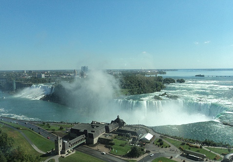
The Niagara Falls complex is located on the Niagara River in
North America. It includes three main streams: the sickle-shaped
"Horseshoe" (width: approx. 670 m, height: 57 m), the so-called
"American Falls" (width: approx. 260 m, height: 57 m), as well
as small waterfall "Veil" (height: 55 m.). The height of the
free fall of water in the "American Falls" is somewhat less -
about 21 m, since the bottom of the gorge is littered with a
heap of stones formed as a result of massive landslides in the
middle of the 20th century. Depth of the pool at the foot of the
Horseshoe: 51 m, which roughly corresponds to the height of the
cliff above it.
According to experts, the average total
volume of water passing through the waterfalls should be 5720 m³
/ s, excluding hydraulic structures. However, the latter
radically change the picture: starting from the second half of
the 20th century, from 50% to 75% of the total flow does not
pass through the riverbed, but through man-made tunnels in which
turbines are driven. In summer, when the power plants are most
productive, the flow of water directly across the cliff drops to
2830 m³/s. The full flow of Niagara is also influenced by
natural factors, such as fluctuations in temperature and
humidity in the Great Lakes system. Calculations made in the
19th century show that the waterfalls were once even more
powerful: for example, in the summer of 1841, the authors of the
first work on the geological study of Niagara measured the speed
of the river flow just above the cliff line, and using the Euler
equation calculated the volume of water: about 10600 m³ /With.
Topographer John Bogart, representing the state of New York,
presented his own calculations in 1890: about 7780 m³/s.
Approximately 90% of the water enters the Lower Niagara Gorge
through the Horseshoe. To the right of the Horseshoe, which is
also called the Canadian Falls, is Goat Island, the largest of
the group of islands adjacent directly to the waterfall. This
piece of land, as well as the Luna Island following it, divide
the river into two more branches, each of which falls into a
canyon under its own name: "Fatoy" between the islands, and
"American Falls" between the Moon and the right river bank.
Formation
The formation of land on the territory of the modern
Great Lakes began more than 300 million years ago, at the end of the
Paleozoic era. On the surface were several layers of crystalline
sedimentary rocks formed in different geological epochs from the
remains of warm sea organisms: dolomites, clay shales, limestones,
sandstones. Further, under the influence of deep processes, the
surface of the Earth began to curve, in place of three of the five
lakes, a basin formed, which was called Michigan. The exposed rocks
along the edges of the basin formed a bulge, which later began to
collapse as a result of erosion. This process was uneven: some
deposits were washed out faster than others, and as a result, the
so-called cuesta was formed: a series of steep rocky cliffs at the
junctions of mountain strata. The Niagara Escarpment, as this cuesta
is now called, stretched for hundreds of kilometers along the
perimeter of the Michigan Basin and, in particular, became one of
the causes of the Niagara Falls.
Over time, the climate has
changed, and over the past 2 million years, the territory of Canada
and the northern part of the United States has been repeatedly
covered with glaciers. The ice shell moved like a bulldozer,
grinding and moving rocks and soil. In some places he deepened and
widened the river beds, creating lakes, and in other places he
filled them up, forcing these rivers to lay new channels. During the
last glaciation 75-11 thousand years ago, known as the Wisconsin,
the modern Great Lakes appeared. At an early stage, all the lakes
were combined into one giant reservoir, which eventually began to
decrease and break up into smaller ones. The forerunner of modern
Ontario was the larger Iroquois Lake; to the south of it and to the
northeast of Lake Erie, another, now disappeared Lake Tonawanda, was
formed.
As the glacier warmed and retreated, meltwater from
some reservoirs flowed into others located below. A narrow strait
formed between Lakes Erie and Tonawanda, the forerunner of the
modern Niagara River. In turn, the water from Tonawand fell into the
Iroquois Lake, in several places smoothly flowing from one reservoir
to another, bypassing the threshold of the cuesta. One of these
spillways was the Niagara Falls, which appeared about 12.3 thousand
years ago. As the water level decreased, the height difference
between the reservoirs increased until Iroquois Lake reached the
foot of the ledge. Lake Tonawanda has almost completely disappeared,
surviving only in the form of the current lower reaches of the
Niagara.
As described above, the bedrock along the Niagara River is composed
of several layers of metamorphic rock formed from compressed remains of
marine organisms. Directly under a thin, no more than one and a half
meters thick layer of glacial rubble lie hard, extremely resistant to
erosion dolomites of the Middle Silurian age (related to the Wenlock
era). This layer occupies a large, about 40 m, part of the height of the
waterfall. Directly below it is a shale layer with an average thickness
of about 18 m, formed somewhat earlier, when the composition of sea
water was different. Shales, like dolomites, are poorly affected by
flowing water. However, with frequent fluctuations in air temperature
around the freezing point, microcracks form in them, into which water
enters and destroys the rock. The lower layer is slowly washed away, and
the upper one, in the form of boulders, falls to the bottom of the
gorge.
Initially, the waterfall was located about 11 km
downstream of the Niagara, between the American city of Lewiston and the
Canadian city of Queenston. Under the influence of erosion, it has
shifted significantly to the south, leaving deep canyons in its path.
The discharge of water in Niagara has repeatedly changed due to changes
in the hydrological regime in the Great Lakes basin. There were periods
when the formed glacial dams redirected the waters of the Huron directly
through the valleys of the St. Lawrence or Hudson rivers, skirting Lake
Erie and the Niagara flowing from it from the north. During such
periods, the volume of water carried was reduced, and the canyons formed
by the waterfall became narrower. At some point, Niagara abruptly
changed direction, making a right-angle turn in a hollow known as the
Niagara Whirlpool. Scientists believe that in this place the receding
waterfall stumbled upon the bed of a prehistoric river that existed
before the onset of the Wisconsin glaciation - the so-called "River of
St. David". The glacier covered the channel with rock fragments, which
were relatively easily eroded under the weight of the falling water and
changed the course of the Niagara River. The section of the canyon where
the modern Niagara river bed coincides with the ancient river bed is now
called St. David's Gorge.
About 600 years ago, Niagara Falls
reached a group of islands, the largest of which was the Goat. The
barrier divided it into several streams, called the "Canadian",
"American" waterfalls, and the "Veil" waterfall. Since the beginning of
the 20th century, the rate of destruction of shale rocks in the area of
the waterfall has significantly decreased due to direct human
intervention: if during the period from 1842 to 1905 the waterfall moved
by 80–100 cm per year, then in 1962–2017, on average, by 40 cm per year.
time interval. According to the International Joint Commission, over the
past decades, the average erosion does not exceed 10 cm per year. The
main reasons for slowing down erosion were a significant decrease in the
volume of overflowing water (part of it bypasses the waterfall through
pipelines), a more even distribution of the remaining flows across the
entire width of the river, and strengthening of the coastline.
Fluctuations in the water level in the Great Lakes system, which
themselves can have both natural and anthropogenic causes, also affect
the speed of the waterfall. There are rapids upstream of the Niagara,
and if the waterfall recedes to their highest point, then its height
will increase by another 15 m, which in turn will increase the pressure
on the bottom and accelerate erosion.
Landslides
From time to time, large landslides occur at the
waterfall. One of such notable collapses occurred in 1931: within two
days, massive pieces of the river bottom with a total mass of 75
thousand tons peeled off one after another in the middle of the American
Falls and fell into the gorge with a big roar. As a result, a recess was
formed at the end of the cliff, 45 meters deep and 40 meters wide. In
1934, 45,000 tons of rocky rubble fell into the Horseshoe Falls from the
direction of Kozyy Island. Finally, another major landslide in 1954,
which brought down 145 thousand tons of debris to the bottom of the
canyon, destroyed the Prospect Point observation deck in the United
States. In contrast to the Horseshoe, where the depth of the basin below
it makes it possible to hide even large fragments of rocks, and the
power of the stream quickly carries them downstream, the bottom of the
gorge on the American bank of the river is filled with stones, which
reduces the height of the free fall of water and partially clutters up
the general view . Several large rockfalls in the late 19th and early
20th centuries in the central part of the Canadian Falls noticeably
changed its shape: it became more concave, wedge-shaped.
Ice jam
The winter of 1847-48 was unusually cold, and Lake Erie was covered with
a thick layer of ice. In early spring, an ice jam formed in the upper
reaches of the Niagara, forming an impenetrable dam. In the early
morning of March 29, the inhabitants of the settlements near the
waterfall woke up from an unusual silence - instead of a powerful
stream, thin streams of water flowed over the edge of the ledge and the
bottom of the river was exposed. Where the water had boiled the day
before, only rare puddles and huge boulders were visible, usually hidden
under water. The reason for what happened was unclear, in local churches
they started talking about the coming end of the world. During the day,
people gathered on both banks, many wandered along the bottom and
collected weapons lost during the war of 1812: bayonets, sabers, gun
barrels, tomahawks. One enterprising resident harnessed the horses and
began to pull out the logs that had once been stuck between the stones.
The owners of the ferry began to blow up large and sharp fragments of
rocks that threaten navigation. A day later, the wind changed, and under
the pressure of the water, the dam broke. Long before the water reached
the waterfall, the inhabitants heard a distant rumble, the earth
trembled.
The described case is the only one known when the
waterfall dried up due to natural causes. Every year, an ice crust forms
on the river, the thickness of which increases during severe prolonged
frosts and, in combination with icicles from the side, can create the
impression of a completely frozen waterfall. Until a certain point,
local residents actively used this “bridge”, moving from bank to bank
and arranging festivities on the river. In the winter of 1912, suddenly
broken ice caused the death of several people.
Indigenous people
Archaeological excavations on the Niagara
Peninsula indicate that the first people appeared in these places in the
9th millennium BC. e. Trade and portage trails ran along the river, and
the waterfalls themselves served as a place of worship, at its foot they
caught fish and picked up the carcasses of dead animals. Tuscarora
artist and writer David Cusick, one of the first Native Americans to put
local legends and traditions on paper, argued that in the pre-colonial
period, the land in the Niagara Valley was the territory of frequent
conflicts between tribes and changed hands several times.
By the
time the Europeans appeared, the Iroquois from the Ongiara tribe settled
here, whom the French explorer Samuel de Champlain called "neutrals" for
their ability to negotiate with neighboring tribes. The word
"Onguiaahra", from which the name of the river and waterfall comes, is
first found in the report of the French Jesuit Charles Lallement on his
visit to New France in 1740. The priest in the letter speaks of "about
40 settlements of neutrals on both banks of the river, 40 leagues south
of the country of the Hurons", while under the name "Onguiaahra" he
means the most eastern of these settlements. Modern scholars disagree on
the original meaning of the word. According to the historian, Professor
of English at the University of California at Berkeley George Stewart,
it translates as "a piece of land divided into two parts." There are
also other translation options: “strait”, “thundering water”, etc.
During the so-called “beaver wars” in the middle of the 17th century,
the neutrals were supplanted by neighboring Indian tribes, who sought to
occupy a more profitable niche in the fur trade with Europeans. By the
time of the active colonization of Niagara, this area was inhabited by
representatives of the Seneca and Mississauga peoples, later Tuscarora.
The legend of the Iroquois girl Lelawala, who dived off a cliff in a
canoe, gained wide popularity. According to one version of the legend,
actively disseminated in various reference books and guides since the
first half of the 19th century, she sacrificed herself to the Thunder
God Hinum, who lived in a cave under the Horseshoe Falls. Local
residents sent gifts to God in the form of food and flowers to protect
them from death. When the offerings failed, the daughter of Chief
Eagle-Eye Lelavala steered her boat straight into the depths of the
waterfall. Hinum's two sons picked her up on the fly, and both fell in
love at first sight. Then the girl promised to give herself to the one
who would tell her how to protect herself from death. The younger
brother said that a huge snake lives at the bottom of the river, which
once a year sneaks into the village and poisons the water in it. Once
Lelavala, in the form of a spirit, made her way into the village and
told her fellow tribesmen about it. When the snake once again went
hunting, the brave warriors were already waiting and mortally wounded
her. Returning with nothing, the snake stretched out along the edge of
the cliff of the waterfall and died, and Lelavala remained to live in
the sanctuary of the God of Thunder, turning into the "Maid of the Mist"
There is some disagreement as to which of the Europeans was the first
to describe the waterfalls he saw. The area north of Niagara was
explored in 1603 by Samuel de Champlain. Members of the traveler's
expedition told him about the spectacular waterfalls, which he noted in
his journal, but had never seen with his own eyes. No documentary
evidence has been preserved that Champlain's compatriot and translator
Etienne Brule visited Niagara, who, among other things, discovered Lake
Erie and lived in these places among the Hurons until his death in 1633.
In 1660, the work "Some Peculiarities of the Country of the Hurons" by
physician François Gendron was published in Paris. The author of the
book, who for some time lived among the neutral Indians, from their
words, described the healing properties of certain stones or salt formed
in the foam of rapidly falling water. Between 1656 and 1674, several
maps of New France were drawn up in Europe, on which Niagara with a
waterfall was indicated, but there was no more detailed information
about it and the objects were located in different places.
Most
historians agree that the Catholic priest Father Louis Enpin was the
first European to see and describe the falls after a journey he made as
part of a group of 16 people. In the 17th century, not a single French
expedition could do without a representative of the clergy. For this
reason, Enpin, who had previously taken part in a similar campaign along
the Mississippi River, was appointed to accompany the explorer René de
La Salle through the uncharted lands of New France. This time it was
necessary to pave the way from Fort Frontenac (built on the coast of
Ontario) to Lake Erie, establish a new fort there and build a merchant
ship. In the autumn of 1678, a detachment under the command of Dominique
de Lucières (Dominique La Motte de Lucières) set off on a brigantine
along the coast of Ontario and on December 6 reached the mouth of the
Niagara, where a palisade had already been set up earlier. An attempt to
go up the river on oars was unsuccessful, rapids and a strong current
interfered. Then the travelers landed on the left (now American) bank
and on snowshoes, together with Indian guides, walked along the river to
its tributary Welland, passing Niagara Falls along the way. The next
morning they returned to the falls and spent some time at the top of the
cliff.
A description of Enpen in French was published in Paris in
1683 in the work "Description of Louisiana" and in 1697 supplemented in
the book "Rediscovery of a huge country in America." The traveler's
works aroused great interest in Europe and went through several
editions. The author's text is full of obvious exaggerations and
emotional epithets: according to him, this huge and terrible natural
phenomenon led travelers "to tremble and horror." The author was
surprised not only by the size of the object (he increased its height
three times, from real 50 to 150 m), but also by the location: in the
view of the priest, waterfalls should be associated with a mountainous
landscape, and not with a plain, as in this case. For this reason, the
artist who depicted the waterfall according to Enpen painted a range of
mountain peaks on the horizon. Other French explorers of the 17th - the
first half of the 18th century, Baron Louis-Armand de Laontan (1688) and
Pierre-Francois de Charlevoix (1720-1721), made up similar, full of
horror ideas about the waterfall.
A more adequate report was made
by the Finnish-Swedish naturalist, a student of Carl Linnaeus, Per Kalm
during an expedition to these places in 1750. In a letter to Benjamin
Franklin (later published in The Gentleman's Magazine) he gave his own
account of what he saw. Calling Enpen "the great liar," Kalm took a
systematic approach to the description, although, like his predecessor,
he was struck by the magnitude of the phenomenon:
Before the water
reaches the island, it flows slowly compared to the movement when it
approaches the island - here its speed grows to the fastest in the
world. The water runs with amazing speed before reaching the waterfall;
it is painted white and in many places shoots the spray high into the
air! The largest and most powerful punt at the moment would turn over
here several times. The current along the western coast of the island is
even faster, churning, foamy and, it seems, faster than the flight of an
arrow. When looking from the edge of the waterfall, you will notice that
the river above it is very sloping, almost like a hillside. At some
point, the river falls down perpendicularly! It's incredibly amazing!
You cannot look at it without fear, at such a huge amount of water
falling from an amazing height!
— New York Legislative Documents,
Vol. 48, 1919
The scientist, using a compass, calculated the
direction of the river's flow, gave a more accurate estimate of the
height of the cliff, and indicated the source of the watercourse - the
Great Lakes. In addition to his main task, Kalm spoke about the Indians,
many of whom he observed in the immediate vicinity of the waterfall.
Notable was the story he retold of two indigenous people who, in a tipsy
state on a canoe, accidentally ended up on an island between two Niagara
streams and could not get out to the mainland. They built a staircase of
linden bark and tried to go down to the foot of the waterfall, but the
turbulent cross flow did not allow them to swim to the shore. A few days
later, their fellow tribesmen came to the aid of the desperate Indians,
who begged for spears with iron tips in the French camp, and with their
help they wade first to the island, and then back together with their
captured comrades.
The earliest evidence of the descent of
Europeans to the bottom of the canyon was preserved in a letter from the
French diplomat and publicist Michel-Guillaume Jean de Crevecoeur,
addressed to his son Alexander. The author of the letter claims that in
1785, together with his friend Mr. Hunter, he visited Niagara and twice
descended to the bottom of a deep gorge - on both sides of the river.
According to Crevecoeur, the second journey turned out to be especially
exhausting and dangerous, during which the researchers not only reached
the foot of the Horseshoe, but also ended up in a cave behind a wall of
falling water.
Modern settlements in the Niagara Falls region arose after the end of
the American Revolutionary War. On the one hand, with the formation of
the state border, loyalists began to emigrate to Canada - supporters of
the British crown. On the other hand, toll roads began to be actively
built in the United States, contributing to the resettlement of the
inhabitants of the young republic. Of great importance was the
compulsion to evict the indigenous inhabitants - the Indians, and the
refusal to grant them civil and property rights.
John Stedman, an
entrepreneur who collaborated with British troops during the Pontiac
Rebellion (1763-1766), is considered the first white man to penetrate
the island located between the arms of the waterfall. After the British
captured Fort Niagara at the mouth of the river of the same name in
1759, Stedman took up convoying and transporting goods across the ledge,
a job that had previously been done by French allies, the Iroquois of
the Seneca tribe. Among other things, he learned to ford the river while
riding a horse, and for some time kept domestic goats and other cattle
on the island. All but one of the animals died during the extremely cold
winter of 1779-1780, and in memory of them the name Goat Island was
assigned to the island. After the end of the Seven Years' War, Stedman
claimed that the Indians had secured his ownership of the river valley
south of Fort Schlosser, including Goat Island and Niagara Falls itself.
The entrepreneur set up an orchard by the river, built a sawmill, a shop
and a tavern. For the rest of his life, Steadman tried to formalize the
plot of land "donated" to him and developed land, but the New York
authorities did not agree, dismissing the corresponding lawsuit and
subsequent appeal.
On the left bank of the river, on the
territory immediately adjacent to the Horseshoe Falls, the British set
up a reservist camp in 1786, called the Chain Reserve. After the Treaty
of Ghent, which put an end to the Anglo-American war, the demand for a
military camp disappeared, and various merchants began to occupy plots
of land, serving wealthy and few travelers at that time. In 1797, a
tavern owned by a certain Charles Wilson was built near the cliff, and
in 1822 the first Pavilion Hotel, owned by William Forsyth, was erected
on the same site. A wide walking trail stretches along the coast, called
"The Front". Thanks to the best view of the falls and the presence of a
large rock Table Rock[en] hanging over the gorge in the form of a
cornice, this promenade later became the main place of pilgrimage for
tourists, as well as a gathering of various merchants, adventurers and
rogues.
Two visits in the early 19th century—by the daughter of
U.S. Vice President Aaron Burr, Theodosia, with her young husband in
1801, and by Napoleon Bonaparte's brother, Jérôme, with his fiancee,
Elizabeth Paterson, in 1803—started a long tradition of honeymoon trips
to Niagara. Among the first guests of the Forsyth estate were the 5th
Duke of Richmond Charles Gordon-Lennox (1818) and Lord Dalhousie (1819).
On the opposite bank, which turned out to be part of the United
States, a different kind of business began to develop. Although there
were also viewing platforms, the main commercial activity was directed
to the industrial use of the river. In 1795, the state authorities
carried out land surveying in the region, and a decade later, one of the
participants in these works, Auguste Porter, bought a large piece of
land. Together with his brother Peter, he built several outbuildings,
including a flour mill, a forge, a rope and leather workshop. On the
site of the old French fortification, destroyed by the British, a new
settlement of Manchester was formed, which by the beginning of the war
had more than a dozen households. The settlement was practically
destroyed during the war of 1812 and rebuilt after it ended. Currently,
this locality is known as the city of Niagara Falls.
The development of transport infrastructure in the 19th century led
to an explosive surge in the waterfall's attendance. Early travelers
spent a lot of time on the road alone: for example, the British writer
and artist John Maud (John Maude) got here from New York in 1800 for
about two months, sitting on horseback. Just five years later,
Massachusetts General Council Speaker Timothy Bigelow spent seventeen
days on the longer journey from Boston, using a wagon and the services
of a newly built toll road originating in Albany.
In 1825,
navigation began on the new Erie Canal, linking the Great Lakes system
to the Atlantic Ocean via the Hudson River. Travel by water became not
only even faster (the journey along the entire length of the canal from
Albany to Buffalo took from 5 to 7 days), but also comfortable:
passengers were accommodated in the cabins of a packet boat - a long
boat that was pulled on the shore by harnessed tow horses. Similar to
the Erie Canal on the Canadian side was the Welland Canal, which opened
navigation in 1829. At the final stop, ferrymen, cab drivers and, for
some time, horse cars were waiting for travelers, delivering them
directly to their destination. By 1845, before a direct rail link
opened, the annual attendance of the natural attraction reached about 50
thousand, doubling in just the last 5 years.
In the first half of the nineteenth century, the Niagara crossing was
carried out mainly by rowboats, which caused not only inconvenience, but
also slowed down trade relations between the United States and Canada
(in 1846, at the foot of the Horseshoe for tourists, a steam-powered
ship Maid of the mist). For the politicians of both countries, the task
arose to establish a direct railway connection between them, which
required a corresponding permanent crossing. Representative of the
Legislative Assembly of the United Canada, William Merritt, proposed the
construction of a suspension bridge in the narrowest part of the Niagara
Canyon, two and a half miles downstream from the falls. This task turned
out to be non-trivial: the suspension bridges of that time were not very
durable and often collapsed under the influence of strong winds or as a
result of resonance. However, having received the approval of the
authorities, the bridge commission hired the architect Charles Ellet
Jr., who received a specialized education in Paris, to carry out the
task. A light and elegant design, consisting of one level and called the
Suspension Bridge of Niagara Falls, was presented by an engineer in the
summer of 1848. Despite initial success, a financial conflict arose
between the commission and the author, as a result of which the latter
was removed from further work and fired.
Ellet was replaced by
another engineer, John Roebling, who immediately rejected Ellet's
creation as too unreliable and proposed his own project, consisting of
stone pylon towers, two decks, wooden trusses and a dense network of
wire ropes that gave the structure the necessary rigidity. Careful
calculations and intuition did not deceive him: Ellit's building in West
Virginia, similar to his own bridge over Niagara, collapsed as a result
of a storm in 1854, without standing for five years. The Roebling
Bridge, opened to traffic in 1855, was two-level: carts moved on the
lower one, trains and pedestrians moved on the upper one. With the
opening of the railway connection, the influx of tourists increased
significantly, and the average time spent at the waterfall was reduced
to one or two days.
Due to increased rail traffic, in 1897 the
stone-wooden Röbling bridge was replaced by the Leffert Buck bridge,
made mainly of arched metal structures. This bridge, now known as
Whirlpool Rapids (literally "rapid whirlpools"), is used for rail and
road crossings of the river.
After the successful Roebling project, it was decided to build
another suspension bridge, this time directly near the waterfall (the
initiators expected to receive additional profit from paid access to the
panoramic view). A wooden bridge with four wooden towers designed by
Samuel Keefer, known as The Falls View Suspension Bridge, was opened in
1869. The small width of the carriageway (about three meters) allowed
carts to move in only one direction, and in the tourist season, a long
line of people wishing to cross to the other side lined up before the
crossing. The bridge received international recognition in the form of a
gold medal at the 1878 World's Fair and was subsequently renovated
several times, becoming wider and stronger. However, despite the
improvements, the suspension structure still proved susceptible to storm
winds and collapsed in Niagara in January 1889. Instead of the lost
bridge, engineers erected another one of a similar design and under the
same name, but in 1889 it was decided to dismantle it and build a new
one.
In the same year, the Kiefer suspension structure was
replaced by the second Leffert Buck Bridge (the first, erected a year
earlier, was 1.5 km downstream), the largest steel arch bridge in the
world at that time. This bridge, better known as Medovy, had a span of
256 m. It was wide enough for not only pedestrians and carts to move
along it in both directions, but also electric trams invented shortly
before. In 1938, the described object also collapsed into the river,
this time as a result of an ice jam that damaged one of its foundations.
In 1939, the British King George VI, together with his wife Elizabeth
Bowes-Lyon, during their trip to Canada and the United States, visited
Niagara Falls, where they solemnly announced the start of the
construction of a new steel crossing next to the remains of the
destroyed one. In 1941, the Rainbow Bridge connected the banks of
Niagara, designed by Edward P. Lupfer and Richard Lee, which is used for
automobile and pedestrian traffic to this day. From the same as its
predecessor, it has an arched structure, however, the bases of the span
rest not on the bottom of the gorge, but on its walls at a height of 15
m above the level of the rivers.
By the mid-1830s, several hotels and guest houses had opened on the
Canadian coast of Niagara, the owners of which not only competed, but
also openly feuded with each other. One of the most advantageous land
plots, directly adjacent to the waterfall, went to a veteran of the War
of 1812, entrepreneur William Forsyth. This adventurous businessman, a
former smuggler and a prisoner, sought to monopolize access to the best
vantage points. For the sake of this, he blocked the coast with a high
fence and began to charge a fee for passage. One of Forsyth's
innovations was the covered spiral staircase he built, leading to the
foot of the Horseshoe and further into the cave behind it. The
entrepreneur behaved quite aggressively: he dismantled the boardwalks
laid by other owners, blocked the work of ferrymen, and, according to
some information, was involved in the arson of neighboring private
property. After a series of complaints and lawsuits, in 1833 he was
forced to cede his land and the luxurious three-story Pavilion Hotel
standing on it to competitors.
In 1835, the history of another
famous Clifton House hotel, built by Harmanus Chrysler, opposite the
American Falls, began. In subsequent years, it was repeatedly rebuilt,
becoming higher and more respectable; balls and lavish parties were held
here. The building was engulfed in fire twice - in 1898 and 1932, after
which it ceased to exist. In 1937, on the site of the hotel, the
garden-architectural ensemble Oakes Garden Theatre, which has survived
to this day, was created.
By the middle of the 19th century, the
tourism industry had become the main one in this region. After the end
of the Civil War, the New York Central railroad began touting Niagara
Falls as a pleasure center and honeymoon destination. On the territory
of the military reserve and part of the former Forsyth possessions, a
pedestrian zone "The Front" was spontaneously formed, about a quarter of
a mile long and 300 yards wide. It combined a promenade with panoramic
views of the falls and a marketplace filled with taverns, souvenir shops
and stalls selling everything from "healing water" and Afghan lapis
lazuli to caged wild animals. There were crowds of photographers,
barkers and all kinds of scammers who swindle money from inexperienced
tourists. For example, one of the well-known crooks was a certain Saul
Davis, who kept the Table Rock Hotel in the 1850s-1870s, nicknamed the
"Cave of the Forty Thieves" in The Times. The businessman engaged in
outright extortion: first, he lured visitors to admire the “boiling
springs” behind the hotel at the foot of the waterfall for free, and
then at the exit, under threat of reprisals, demanded to buy out the
oilcloth raincoats provided to tourists at a fabulously high price.
Another notable figure of the century was the Englishman Thomas
Barnett, who, in addition to his own hotel business, opened the Niagara
Falls Museum of Natural History to visitors. Having settled here in
1831, he began to advertise "a magnificent collection of natural and
artificial curiosities", which included, among other things, about 700
stuffed animals ranging in size from hummingbirds to red deer. In the
future, the museum moved several times to more spacious premises,
significantly replenished its exposition and by the middle of the
century became one of the main attractions of the recreation area. In
addition to zoological exhibits, his collection included samples of
Chinese weapons, paintings by Japanese artists, shields of Pacific
island warriors, and even mummies of Egyptian pharaohs. The passion for
collecting eventually led Barnett to bankruptcy, and in 1877 the
museum's collection was sold at auction for debts. At the end of the
20th century, about 700 thousand surviving exhibits of the museum were
bought by the collector Bill Jamieson, who sent some of them for
examination. To the surprise of experts, many of the items previously
thought to be forgeries turned out to be genuine, including the mummy of
Pharaoh Ramesses I, which was thought to be lost.
Under the terms of the Ghent Peace Treaty, Goat Island remained
within the borders of the United States, and local authorities, who
originally planned to equip it with an arsenal or prison, put the land
up for auction. The buyers in 1815 were Auguste and Peter Porter, who
already owned a large estate on the right bank of the Niagara.
Initially, the entrepreneurs planned to use the island mainly to build
mills and other industries that use water energy, and to transport the
goods produced on them up and downstream. However, with the opening of
the Erie Canal, the traditional transportation business along the river
has declined, and the tourist flow, on the contrary, has grown
significantly. Businessmen switched to creating infrastructure to serve
travelers, but the island itself remained lightly affected by economic
activity for decades. The English botanist Sir Joseph Hooker, who
surveyed the local vegetation in 1879, discovered a rich variety of
plants on Goat Island - more than on any other similar area in Europe
and America west to the Sierra Nevada mountains.
Like other
entrepreneurs in the area, the Porters viewed their territory as a
profit center, but instead of building hotels, they erected a wooden
bridge and, for a fee, opened the island to the public, viewing it as a
corner of nature in the middle of an industrial environment. Several
facilities have been built on the western periphery of the island, in
places where tourists gather. So, on a group of stones protruding from
the water, an observation deck was equipped, called Terrapin Rocks. On a
large rock, to which the scaffolds led, in 1833 a cylindrical stone
building with a staircase was erected - the Terrapin Tower. To the niche
discovered behind the Veil waterfall, called the Cave of the Winds,
stone steps were cut through, having previously cleared the cliff from
boulders. Later, in 1858, several more bridges led to a group of small
islands in the middle of the rapids south of Goat Island; this
"archipelago" is better known as the Three Sisters Islands. The original
buildings of the Posters have not been preserved. The Terrapin Tower
fell into disrepair and was blown up with dynamite in 1873, and the site
itself was destroyed and rebuilt in the 1980s.
One of the notable
figures in the history of Niagara Falls in the 19th century was
businessman Parkhurst Whitney. One of the first residents of Manchester,
he bought the Eagle Tavern from a certain Joshua Fairchild in 1815. To
earn at the expense of travelers, he built a staircase from the yard of
his household to the bottom of the canyon to the river and began to
collect remuneration - just as William Forsyth did on the east bank.
Both entrepreneurs joined forces and organized a boat ride from one
hotel to another, thus starting a tradition of boat trips at the foot of
the waterfall. In 1831, Whitney purchased another hotel, the newly built
Cataract House. In time, this hotel, originally conceived as an
extension to a tavern, became no less fashionable than the Clifton House
Hotel located on the left bank: both included banquet and dance halls, a
billiard room, a room for entertainment, and a garden. Many famous
personalities of that time stayed at the hotel, including the future
President Abraham Lincoln (1857). Like its Canadian counterpart, the
hotel was rebuilt several times and was eventually fatally damaged by a
devastating fire, in this case in 1945.
Numerous souvenir and
pseudo-antique shops lined up along the cliff - in this respect, the
American coast differed little from the Canadian one. By the middle of
the century, all observation platforms were blocked by fences; visitors
did not have the opportunity to admire the waterfalls and rapids for
free. Visitors left impressive sums to go around all the attractions
that offered promotional brochures.
During the 19th century, the waterfall gradually lost its
attractiveness - partly due to the transformation of the right bank into
an industrial cluster, partly due to the activity of merchants trying to
lure as much money from vacationers as possible. An example is the
famous traveler Isabella Bird, who, according to her memoirs, was
pursued everywhere by importunate sellers, barkers and drunken cabbies,
not giving them the opportunity to retire and relax. There were so many
complaints that the governor of Ontario, Oliver Mowat, in 1873
established a special commission to combat fraud. The constables sent to
help helped reduce crime in part, but did not have the power to
interfere with the commercial activity itself. In the United States,
numerous industrial buildings blocked the view of the river, and a few
viewing platforms were available only for a certain fee.
In the
summer of 1869, a meeting took place at Goat Island and later at the
Cataract House Hotel that had far-reaching consequences. Landscape
architect Frederick Olmsted, architect Henry Richardson, and Buffalo
federal attorney William Dorsheimer discussed the possibility of
establishing an international conservation area adjacent to the falls.
The initiator of the idea was Olmsted, who by that time had already
become famous thanks to the creation of Central Park in New York and the
organization of a protected area in the Yosemite Valley. An active
conservationist, Olmsted offered to petition the authorities of New York
and Ontario to buy their plots from the owners and recreate the virgin
landscape on them - the way Louis Enpin saw it. The project, known as
Free Niagara, did not develop for a long time: the initiators did not
have enough influence on the authorities, and publications in The Nation
magazine and the two-volume Picturesque America did not find the right
response. After 9 years in 1878, the artist Frederick Church joined the
initiators, who, in turn, managed to win over the viceroy of the British
crown, the Governor General of Canada, Lord Dufferin. The latter,
speaking at a meeting of the Society of Artists, announced the creation
of a joint park with the United States in the form in which it was
represented by projectors. New York Governor Lucius Robinson was also
convinced of the need to create a natural reservation, but a
corresponding decision of the state legislature was required.
While a commission appointed by Parliament was studying the possibility
and cost of requisitioning, in New York, an opponent of the
implementation of Alonso's idea, Cornell, became the new head. In
Ontario, Mowat, although he agreed with the directive of the
representative of the queen, nevertheless laid all the costs on the
federal government. Representatives of the Macdonald cabinet in Quebec
and the poor Maritime provinces protested: if in the USA a single state
is responsible for financing, then why should the whole country pay for
the conservation area in Canada? Faced with resistance from the
authorities, Olmsted organized a collective appeal signed by hundreds of
influential people of the time, including Harvard University professor
Charles Norton, historian Francis Parkman, founder of the theory of
evolution of species Charles Darwin, writers Thomas Carlyle, Ralph
Emerson, Henry Longfellow, John Ruskin , Oliver Holmes and John
Whittier, US Supreme Court Chief Justice Morrison Waite. A series of
letters from journalists Henry Norman and Jonathan Harrison to
newspapers in New York and Boston did much to change public opinion.
The situation was reversed only after a new change of governor of
New York: in early 1883, Grover Cleveland, a fan of the Free Niagara
movement, became the governor. On March 14 of the same year, the state
legislature voted in favor of a bill establishing the Niagara
Reservation on its territory (English Niagara Reservation, now Niagara
Falls State Park); another signed law allocated the necessary funds for
this. In 1886-1887, a large-scale reconstruction of the recreation area
was carried out according to the design of landscape architects
Frederick Olmsted and Calvert Vaux. All outbuildings and structures were
demolished or covered. Paths were laid along the coast and observation
platforms were equipped. Numerous trees were planted, imitating the
original appearance, as the discoverers found it. A new bridge was laid
on Goat Island. Toilet rooms, lanterns and rubbish bins were added - but
in such a way as to smooth out, mask the traces of human activity as
much as possible.
The government of Ontario, having not received
funding at a higher level, decided to attract private business. Two
groups of entrepreneurs applied for the creation and management of a
commercial free public park. At the same time, businessmen pursued their
own undisclosed goals, primarily the construction of a new railway on
the territory of the recreation area and the creation of appropriate
infrastructure. Powerful politicians were behind both groups, and Oliver
Mowat appointed a commission to select one of the two projects, thus
relieving himself of the responsibility for making the decision. The
commission, headed by Kazimir Gzowski, a Polish émigré from the Russian
Empire, came to an unexpected conclusion for the governor: the 118-acre
recreation area being created should be restored to its original
appearance, as far as possible, and managed by a state structure.
According to Gzovsky's plan, a small amount should have been charged for
the services of a guide to the budget of the reserve; otherwise, entry
was to be free. A new recreational area, called Queen Victoria Park, was
proclaimed in the spring of 1887 and opened to visitors a year later on
the monarch's birthday on May 24. As on the American side, most of the
buildings were demolished and green spaces planted. The government
nevertheless established a small fee for the entrance to individual
alleys, the use of covered bridges and an elevator to the bottom of the
canyon.
Currently, the public recreation area adjacent to the falls is
largely different from what the Free Niagara activists envisioned. Queen
Victoria Park never became an "island of the virgin forest" - now it is
more of a classic-style park with mowed lawns, flower beds, avenues,
fountains and rock gardens. The Niagara Riverwalk within the park is a
paved boardwalk overlooking the falls and upper rapids. Near the place
where the rock of Table Rock once stood over the gorge, a complex of
buildings was built in 1925-1008, called the Table Rock Center
(originally Table Rock House); there is an information centre, a
restaurant and an observatory. Two buildings of Canada's first power
plants remain in the park: Toronto Power and Ontario Power. The first of
these buildings is empty, the second is used by film and television
workers.
The fairground and carnival-type business has shifted to
Clifton Hill leading to the river and the lanes adjacent to it: numerous
wax museums, “ghosted castles”, arcade galleries, gift shops, mini-golf
courses and other entertainment industry establishments are located
here. Here you can also find forgeries of artifacts put on public
display, with the help of which the "tamers" of the waterfall once
performed their tricks - for example, the barrel of dance teacher Annie
Taylor. In 1965, the 52-story Skylon observation tower opened on the
Canadian coast, from the height of which a circular view of the
surroundings, including waterfalls, the cities of Buffalo and Toronto,
opens. Outside the boundaries of Queen Victoria Park, but in the
immediate vicinity of the falls and overlooking it, several casinos are
open.
In New York, between 1924 and 1935, the Niagara Valley
Conservation Area increased by another 2,000 acres (≈8 km²) with five
new state-run parks. Most of the green spaces on Goat Island have
survived to this day, here you can still retire among thickets of birch,
willow and hickory. Another part of the forest was cleared in 1951 to
create car parks and a helicopter landing pad. The heap of Terrapin
Rocks at the foot of the Canadian Falls, on which the tower stood in the
19th century, is now an artificial extension of Goat Island: today it is
an elongated green lawn with Terrapin Point paths, overlooking the
Horseshoe from the American side. The original Cave of the Winds, after
several collapses and closures in 1955, was finally destroyed by an
explosion. At present, wooden scaffolding leads to the Fata waterfall,
behind the veil of which there was once a cave, in the warm season,
which has retained its former name. In 1976, a monument to Nikola Tesla
by the Yugoslav sculptor Franjo Krsinich was erected on the island.
In 1961, on the site of the Prospect Point observation deck
destroyed by a landslide, the eponymous 86-meter observation tower was
opened, which offers a panoramic view of the falls. Near the tower there
is a pier, from which, as before, excursion boats Maid of the Mist
depart. Since 2020, the company operating this most popular attraction
in Niagara Falls has been operating electric-powered boats, abandoning
the diesel engines that have been used for decades. Since 1971, the
Niagara Gorge Discovery Center, a museum that tells the geological
history of Niagara Falls, has been open on the site of Schölkopf's first
Niagara power plant since 1971. There is an information center in the
park to help visitors.
At night, the waterfalls are illuminated.
The tradition dates back to 1925, when night illumination became
permanent. Since 2016, lighting has been carried out using LED lamps.
At the turn of the 19th and 20th centuries, about one million people
visited Niagara Falls annually, but there were exceptions associated
with certain events: for example, only during the Pan American
Exhibition in nearby Buffalo in 1901, the number of guests on the
reservation grew to 3 million people. The popularity of the natural
attraction among tourists increased significantly after the end of the
First World War due to the spread of automobile traffic: by 1925, the
average number of visitors had grown to two million.
An even
sharper increase occurred after the Second World War due to the large
number of newlyweds, especially on the Canadian side, where the
recreation area adjacent to the falls was reconstructed and the tourist
infrastructure was improved. According to experts, in the mid-1960s, the
number of tourists to Niagara reached 5 million people a year. Some
advertising for honeymoon trips was created by the film "Niagara"
(1953), in which the main performers Marilyn Monroe and Joseph Cotten
took part in location shooting against the backdrop of a waterfall.
After the screening, local business workers received a wave of letters
demanding to reserve a room in a fictional motel in which the characters
of the film lived. In 1990, the famous illusionist David Copperfield in
one of his shows "descended" the waterfall on a burning raft, which also
contributed to the popularity of this place.
Information about
the current attendance is contradictory, various sources call from 22 to
30 million people annually. A Canadian government agency estimated the
number of tourists visiting Queen Victoria Park in 2017 at 14 million.
The official authorities of New York announced 9.5 million visitors to
the American park in 2019, but journalists from The Buffalo News
expressed doubt about this number, calling it greatly inflated.
The discovery and rapid development of the electric power industry at the turn of the 19th-20th centuries led to the emergence and improvement of a huge number of technologies that were revolutionary at that time (this period in modern historiography was called the “second industrial revolution”). Niagara played a significant role in this process, where several hydroelectric power stations were built within just two decades, producing clean and relatively cheap energy. The inventions of Nikola Tesla made it possible to convert the energy of water into electricity and transmit it over a considerable distance. Other discoveries in physics have made it possible to convert this energy into light, heat, and mechanical work.
The great power of the waterfall has long been considered as an
inexhaustible source of energy. The first attempt dates back to 1757,
when the French officer Daniel-Marie Chabert de Joncaire dug a small
ditch on the right bank of the river just above the falls to supply
power to his sawmill. In the first half of the 19th century, Auguste and
Peter Porter, the owners of the land on the site of the remaining French
moat, took the initiative to create a drainage channel, the water from
which would drive the turbines of the mills and then drained off the
cliff downstream. Under their patronage, in 1853, former New York Mayor
Caleb Woodhull founded the Niagara Falls Hydraulic Company, which
received ownership of the necessary land and a contract for the
construction of a hydraulic structure. A construction plan was drawn up,
but work never began, first due to lack of funds, and then due to the
death of both trustees.
Woodhull's successor was entrepreneur
Horace H. Day, who renamed the business the Niagara Falls Canal Company
and launched the planned drainage canal in 1861. The project turned out
to be unprofitable: with the outbreak of the civil war, the canal
remained unclaimed for a long time. Only in the first half of the 70s,
Charles Gaskill's flour mill began to use Day's services, but by that
time the enterprise itself, which had continued to complete the
construction for all previous years, had finally fallen into decay. In
1877, Horace Day was declared bankrupt and the canal was put up for
auction.
In 1878, Jacob Schölkopf became the owner of the canal,
seeing new opportunities in its use. He set up his own Niagara
Hydropower and Mining Company, greatly enlarged Day's structure, dug two
offshoots from the main stream, and installed gates. With the help of
the new facility, the entrepreneur connected seven enterprises to the
consumption of hydropower, two of which he personally controlled.
Initially, hydroturbines transmitted energy to consumers using
mechanical drives. In 1881, a businessman built at the bottom of the
gorge one of the first hydroelectric power plants in the world - Station
No. 1", which produced direct current. There was enough energy to light
the waterfall itself and street lamps in the nearby village with the
help of Charles Brush arc lamps.
After the formation of the
reservation, industrial production shifted directly beyond the
boundaries of the protected zone. In 1889, the Cataract Company (later
the Niagara Energy Company), headed by banker Edward Adams[en], dug a
two-kilometer drainage tunnel under the settlement of Niagara Falls. The
famous New York engineer Thomas Evershed became the developer of this
structure. Initially, it was assumed that the tunnel would be equipped
with many small wheel pits, to which plants and factories would be
connected; however, there was no sufficient number of industrial
consumers in the district. It was necessary to find a solution for
transmitting energy over a distance, primarily to the industrial city of
Buffalo located 32 km from the falls. To this end, in 1890, Adams
organized a prestigious international competition led by Lord Kelvin,
which considered technical solutions for the transmission of energy
using fluid mechanics, pneumatics, or electricity. None of the proposed
projects, including that of the leading American electrical inventor
Thomas Edison, was deemed workable. Three years later, the organizers of
the contest drew attention to the invention of the alternator by Nikola
Tesla, who, together with engineer George Westinghouse, was lighting the
Chicago World's Fair.
In 1883, Adams hired Westinghouse's firm to
install two two-phase Tesla alternators with a total capacity of 15,000
horsepower (subsequently, the two-phase system was replaced by a
three-phase one). By 1896, with financial assistance from magnates such
as John Pierpont Morgan, John Astor IV, and members of the Vanderbilt
family, the number of generators had grown to ten, and the total power
to 50,000 horsepower (37 megawatts). In 1899-1904, the second stage of
the hydroelectric power station was built, the amount of energy
generated doubled. Giant underground pipelines were created, connected
to hydroelectric units, from which electricity was delivered at high
voltage to consumers in the surrounding cities. The population of
Niagara Falls began to grow rapidly: if in 1889 about 500 people lived
in the village, then a decade later, at the turn of the century, about
20 thousand. By this time, the settlement had become the center of the
electrochemical and electrometallurgical industry: Charles Hall, the
inventor of aluminum production by electrolysis, and Edward Acheson, the
discoverer of the silicon carbide synthesis process, were among the
first to settle here. By 1909, 25 large industrial enterprises were
opened in the city. Among other things, acetylene, alkalis, caustic
soda, chlorine and lime were produced here, later also ferroalloys,
graphite products and abrasive materials.
In 1927, the
hydroelectric plant was named after Adams; gradually its importance
decreased until it was finally stopped in 1961 after the commissioning
of more powerful and efficient hydroelectric power plants. Most of the
station's structures were dismantled, only the transformer building,
which has the status of a historical monument, has survived to this day.
The Schölkopf power station gradually increased its capacity, in the
years 1898-1924 several stages of hydroelectric power stations were
built, as a result, it reached a capacity of 400 MW and became the
largest hydroelectric power station in the world at that time. In 1918,
Schölkopf's company was merged into the Niagara Falls Power Company. On
June 8, 1956, most of the structures of the hydroelectric power plant
were destroyed as a result of a landslide, which was caused by many
years of water leakage from the water supply system. There were 40
employees at the station at the time of the incident; all but one man
managed to escape. The station was declared beyond repair, its remains
were dismantled, and the supply channel was filled up.
The first small (with a capacity of about 2 MW) hydroelectric power
plant on the left bank, created by the Niagara Falls and River Railway
and called the "International Railway Plant", began operation in 1893;
on the direct current received with its help, trams operated,
transporting passengers between the settlements of Chippewa (Chippewa,
now a historical district within the boundaries of the Canadian city of
Niagara Falls) and Queenston. This power plant operated until 1932.
At the beginning of the next century, two larger enterprises owned
and controlled by the Americans began to operate on the coast: Canadian
Niagara Power (1904) and Ontario Power (1905). Both stations, despite
their names, had nothing to do with the Canadian economy: all the
electricity produced by them was transported to the opposite bank, where
an explosive growth of the economy was observed.
In 1905, the
Canadian Niagara Power hydroelectric plant (owned by the same investors
as the Adams plant) was put into operation, later named after William
Rankin, the founder and leader of the company, who died three days after
the start of the hydroelectric power plant. The last of the 11 hydraulic
units of the HPP started operating in 1927, after which the station
reached its full capacity of 102,500 hp. With. (about 75 MW). The
hydroelectric power plant produced electricity (alternating current with
a frequency of 25 Hz) for 100 years after start-up - until 2005. That
same year, Ontario Power's larger hydroelectric plant began operating.
Its equipment included 15 hydraulic units with a total capacity of 132.5
MW, which produced alternating current with a frequency of 25 Hz
(reconstructed in 1972-1976 in order to transfer to a frequency of 60
Hz). This hydroelectric power plant was closed in 1999, because it was
decided to build a casino on the land on which its transformers were
located.
Canadian authorities initially did not consider
electricity as the main source of energy, priority was given to steam
engines. The situation began to change in 1902, when the price of
anthracite rose sharply in connection with a large-scale miners' strike
in Pennsylvania. Even when the conflict was resolved, customers in the
United States continued to receive raw materials in the first place,
while Canadians faced a sharp shortage of it.
The task of
generating alternating current for Toronto's industrial plants was
successfully carried out by three Canadian businessmen: railroad tycoon
William Mackenzie, GE Canadian Vice President Frederic Thomas Nicholls,
and financier Henry Pellatt. The Electrical Development Company
syndicate they created in 1906 commissioned the Toronto Power Generating
Station with a capacity of 125,000 horsepower. The outlet tunnels, about
700 feet long and 150 feet deep, started a little higher than the
Horseshoe cliff, in the place of the most powerful rapid, and ended
exactly at the end of the waterfall, behind the veil of the main stream;
thus, the builders managed to avoid the unsightly picture characteristic
of the American coast. Hydro turbines located at the bottom of the mine
were connected by long shafts to hydro generators located on the
surface, which generated electricity. For the construction of the main
building, in which the generators were then installed, the entrepreneurs
hired the famous architect Edward Lennox. The majestic Beauzar-style
structure he designed, completed in 1913 and rather reminiscent of a
palace, was decorated with a portico and a colonnade from limestone
brought from Indiana.
In 1917 and 1922, the Ontario Power and
Toronto Power stations came under the control of the state corporation
Ontario Hydro. The latter continued to produce energy until 1974, when
the management decided to close it. The reason for the shutdown was the
fact that the station continued to produce current with a frequency of
25 Hz, while most consumers switched to the new standard of 60 Hz.
Customers were switched to the networks of the two more modern Sir Adam
Beck stations downstream of the Niagara. In 1983, the Canadian federal
authorities recognized the surviving Turbine Hall building as a National
Historic Site[en] of the country. “The power plant is the first wholly
Canadian-owned hydroelectric facility in the Niagara Falls region; its
engine room is an early and unusual example of the use of the Beaux-Arts
style in Canadian industrial architecture.
With the beginning of the work of the first
Canadian stations in this country, a movement arose advocating the
transfer of energy networks to public administration. Adam Beck, who led
this movement, convinced the Ontario cabinet to establish a special
agency for the development of hydroelectric power. The Hydro-Electric
Power Commission, which he headed, later transformed into the state
corporation Ontario Hydro, became one of the largest energy companies in
North America. The company's first project was the construction of the
Queenston-Chippawa hydroelectric power plant near Queenston. The
construction of the hydroelectric power station began in 1917, the first
hydroelectric units began to generate electricity in 1922, the last,
tenth machine was launched in 1930. To supply water to the HPP building,
a channel 13.7 km long, 13.7 m wide and 10.4–12 m deep was dug,
supplying 549 m³/s of water. In addition, the bed of the Welland River
was widened and deepened over a distance of 6 km, while the direction of
the flow of the river in this section was reversed - now Niagara water
flowed through it. Initially, this hydroelectric power station, like
other early hydroelectric power stations of Niagara Falls, generated
current at a frequency of 25 Hz; subsequently, the hydroelectric units
were gradually converted to a frequency of 60 Hz, this process is
planned to be completed in 2022 with the replacement of the two oldest
hydroelectric units. In 1950, this power plant received the name of the
founder of the company - "Sir Adam Beck 1". Initially, its capacity was
403.9 MW, later it was increased to 432 MW. In 1951, the construction of
a second, much more powerful hydroelectric power station, Sir Adam Beck
2, began next to it, 16 hydroelectric units of which were put into
operation in 1954-1958. Initially, the station's capacity was 1223.6 MW,
currently it is 1499 MW. Water was initially supplied to the station's
hydraulic units through two tunnels, each about 8 km long and 13.7 m in
diameter, at the time of creation - the largest in its class in the
world, ending in a 3.6 km long canal. In 2006-2013, a third tunnel was
laid, 10.2 km long and 12.7 m in diameter, which provided additional
water volumes in the amount of 500 m³ / s, released after the
decommissioning of old hydroelectric power plants. Simultaneously with
the HPP, the Sir Adam Beck pumped storage power plant (PSPP) with a
capacity of 174 MW (6 reversible hydro units) was built and put into
operation in 1957, for the operation of which a storage pool 3.8 km long
and 0.8 km wide was created. At night, when under the terms of the
agreement, the hydroelectric power plant's output is maximum (and the
demand for electricity is reduced), this plant operates in pumping mode,
consuming electricity and pumping water into the upper basin. During
periods of peak loads, the station switches to generator mode,
triggering water from the pool and generating electricity
(simultaneously supplying water to the turbines of hydroelectric power
plants).
In the United States, the construction of a new
hydroelectric power plant under the control of the state of New York for
a long time could not get the approval of the US Senate, partly because
of the "anti-communist" sentiment that dominated there, rejecting any
economic projects without the participation of private capital. The
situation changed after the destruction of the Schölkopf hydroelectric
power station, when American industry was on the verge of an energy
crisis. The construction of a large new power facility owned by the New
York Power Authority (NYPA) was carried out by Robert Moses, a state
official, by then known for various infrastructure projects in New York
City. The construction of a new station, named after Moses (Robert Moses
Niagara Power Plant), was started in 1957, and already in 1961 it began
to generate electricity. The HPP building houses 13 hydroelectric units
with a total capacity of 2,525 MW (originally 2,300 MW), which are
supplied with water through two tunnels, each of which is 7.2 km long,
14 m wide and 20 m high. Sir Adam Beck 2", simultaneously with HPP
"Robert Moses" was built pumped storage power plant "Lewiston" (Eng.
Lewiston Pump Generating Plant) with a capacity of 240 MW (12 reversible
hydro units), with an extensive upper basin.
For 2021, the Sir
Adam Beck 1 and Sir Adam Beck 2 HPPs, the Sir Adam Beck HPP on the
Canadian side, and the Robert Moses HPP and Lewiston HPP on the US side
are the only hydropower plants operating in the Niagara Falls area.
According to 2020 data, the total capacity of the hydropower complex of
Niagara Falls is 4870 MW (including the capacity of HPPs - 4456 MW, PSP
- 414 MW). Buildings of hydroelectric power plants are located along the
banks of Niagara below the falls, almost opposite each other. From 50%
to 75% of all water passing through Niagara is diverted through five
tunnels and one channel, starting upstream from the falls itself.
Ships circumnavigate the falls via the Welland Canal, which was
upgraded in the 1960s to become part of the Saint Lawrence Seaway,
allowing ships to enter the Great Lakes from the Atlantic Ocean
bypassing the port of Buffalo. Local shipbuilding and steel mills,
bakeries and other businesses that flourished until the 1970s thanks to
the proximity of energy sources were forced to close or drastically
reduce their activities. The region's economy collapsed.
In the 20th century, the so-called “remedial”
and “control” works at Niagara Falls gained popularity, which meant
engineering projects aimed at changing the hydrology and landscape of
the river, including changing the shape of the crest of the waterfalls.
The list of such projects includes the construction of dams, dikes and
diversion channels, the transformation of the bottom topography and
coastline. The modern, largely artificial, state of Niagara Falls was
formed in the second half of this century, when the United States and
Canada agreed on joint actions in this direction.
Water
withdrawal limitation
At the beginning of the 20th century, the rapid
development of hydropower caused fears that much of the Niagara water
would pass through the falls through channels and tunnels, which would
affect the aesthetic perception of the natural site. Public figures in
the United States, such as Horace McFarland (J. Horace McFarland),
advocated a legislative restriction of water intake from both banks of
the river. McFarland's appeal was supported by President Theodore
Roosevelt and later by the US Congress.
The first
intergovernmental agreement between the United States and Canada
governing the flow of water in Niagara was the Boundary Waters Treaty,
signed by President William Taft and King Edward VII in 1909. The
parties agreed to set a limit on water consumption for the sake of
electricity production: no more than 36 thousand cubic meters. feet per
second (1020 m³ / s) on the Canadian coast and no more than 20 thousand
cubic meters. feet per second (566 m³ / s) on the US, in total about a
quarter of the total volume of flow.
Within the framework of the
agreement, the International Joint Commission[en] was established to
deal with the use of water areas (primarily water level control) along
which the state border passes. In subsequent years, this agreement was
repeatedly violated, in particular during the Second World War, when the
power plants of both countries operated at full capacity.
In the
1920s and 1930s, government commissions calculated how much water was
aesthetically pleasing to satisfy the needs of visitors who wanted to
enjoy the beauty. Not only the volume of the stream was taken into
account, but also the width and height of the waterfall, the
transparency and color of the water. The last factor was of particular
importance: it was believed that the emerald-green hue of the river,
preserved in the works of artists, gave the natural object a special
charm.
In 1950, the states signed the Niagara Diversion Treaty,
which established new rules for the use of Niagara's water. According to
this agreement, which is still in force, drainage is carried out on a
parity basis: each party has the right to equal use of the flow for
hydropower needs. The document emphasized that the United States and
Canada recognize "their primary responsibility to preserve and enhance
the scenic beauty of Niagara Falls and the river and, in accordance with
this obligation, a common interest in ensuring the most beneficial use
of the waters of this river." For the first time, the water withdrawal
limit was tied to the time of the greatest visit by tourists. According
to the agreement, at least 100 thousand cubic meters must flow through
the waterfall. feet per second (2832 m³/s) from April 1 to September 15
from 8 a.m. to 10 p.m., and from September 16 to October 31 from 8 a.m.
to 8 p.m. 50 thousand cubic meters feet per second (1416 m³/s). After
the entry into force of the agreement, from half to three-quarters of
the Niagara flow of minutes falls through tunnels parallel to the river
and is used to generate electricity.
The first steps to slow erosion were taken in the 1880s, when a
protected area was being developed in the United States. The coastline
of Goat Island was leveled and reinforced with buttresses - vertical
structures made of wood and stone. The hydraulic structures that existed
at that time - dams, canals and weirs - were eliminated. On the Canadian
side, excavation work to strengthen the coast was carried out in 1905:
part of the gorge on the territory of Queen Victoria Park with a total
area of about 50 acres (≈ 200 m²) was covered with soil left over from
the construction of pipelines.
In the first half of the 20th
century, several underwater dam projects were implemented to redirect
part of the flow into tunnels. The first attempt was made by Canadian
engineers in 1905 when a 50-foot (≈15 m) concrete pillar was dropped
near the Toronto Power Generating Station. The column partially sank
onto the stones protruding from the water, but still the power engineers
managed to create a small dam, raising the water level in this place by
several centimeters. More productive dams were built in 1929 and 1942,
in the second case by the joint efforts of specialists from the United
States and Canada. As a result of the work carried out, as well as
cleaning the channel along the left bank from large stones, it was
possible to somewhat even out the flow distribution over the entire
width of the river and make the Horseshoe crest less concave. The volume
of water erupting through the American Falls has roughly doubled.
More extensive work was carried out after 1950, when the Border
Waters Treaty was signed between the United States and Canada and a
joint commission took up the change of the waterfall. The US Army Corps
of Engineers dredged along Goat Island, diverting the flow from the
middle, deep part of the river to the eastern flank of the Horseshoe.
The soil excavated to the surface was used to expand the island due to
the Terrapin Rocks - an observation deck, known as Terrapin Point, arose
in this place. Dredging was also carried out along the Canadian coast by
Ontario Hydro; this time the flow was diverted to the western periphery
of the falls. Massive concrete structures were created to act as props
on Goat Island and on the Canadian coast. Lined with stone, they create
the illusion of a natural cliff. The depth of the Niagara at the edges
increased, making it more like a canal, and the width of the Horseshoe
decreased by 400 feet (122 m). In 1957, the joint efforts of the United
States and Canada completed the construction of a water control
structure - a dam, which is located above the waterfall, from the
Canadian coast to a small island in the middle of the riverbed. The dam
is equipped with 18 gates, with the help of which it regulates the
volume of water, both sent to the waterfall and taken to generate
electricity at the hydroelectric power station.
One of the largest projects to change Niagara Falls was the draining
of the American part of it in 1969. By this time, US visits to the
natural site had declined somewhat, partly due to large-scale landslides
that had happened earlier, partly due to improved tourist infrastructure
on the opposite bank. Several large landslides formed a scree of debris
under the cliff, which, unlike the Horseshoe, was not hidden under water
and was not carried away by the current. Almost nothing remains of the
popular Prospect Point observation deck and the original Cave of the
Winds. Among experts, there was a fear that the collapses that occurred
could provoke further destruction of the rocks and the transformation of
the American Falls into a cascade - a series of relatively small
waterfalls falling in ledges. The state authorities decided to explore
the possibility of cleaning the channel and strengthening the rocky
slope to prevent further erosion.
In June of this year, the Corps
of Engineers erected a stone and earth dam between the right bank of the
river and Goat Island, as a result of which part of the Niagara stream
went along another branch of the river through the Horseshoe, and the
other part went into the diversion tunnels. The dry bed of the Niagara
exposed many coins and other artifacts, as well as the remains of two
people - probably suicides. Geologists made a study of the bottom,
including drilling a lot of cores - images of rocks in the form of
cylinders. Cameras with a flash were lowered into the wells, filming
every centimeter. Scientists have found that the bottom of Niagara and
the cliff are covered with numerous cracks, including quite wide and
deep ones. With the help of the dye, it was possible to find out that in
some places water seeped through the cracks into the lower canyon,
bypassing the slope. Experts came to the conclusion that the heap of
debris under the cliff serves as a backup, their removal can provoke
another collapse in the foreseeable future. As a result, it was decided
to leave everything as it is, and in November 1969, the "American Falls"
and "Veil" returned to their former form. Luna Island - a small patch of
land between the waterfalls - remained closed to the public for several
years due to fear that it could collapse at any moment.
The ship "Michigan"
From the very beginning, the owners of the
plots of land located near the waterfall offered travelers additional
services and entertainment, such as a ferry crossing or a bath. The idea
of using the waterfall for a spectacular performance was first realized
in September 1827. Businessmen William Forsythe, John Brown and
Parkhurst Whitney organized rafting through the falls of the "pirate
ship" - the old lake schooner "Michigan", on board which they placed
"fierce animals": a bison, two bears, two foxes, a raccoon, an eagle, a
dog and fifteen geese. The enterprise turned out to be commercially
successful: the hotels were overcrowded, according to various estimates,
from ten to twenty thousand people gathered to watch the crash. Even on
the rapids, before reaching the slope, the ship lost its masts and broke
in half. Bison and bears rushed overboard, one of the last managed to be
caught and put back. After the waterfall, one of the geese survived, the
rest of the animals died.
Jumps and falls
In 1829, the first
daredevil appeared on the shore - twenty-three-year-old Sam Patch,
nicknamed the Yankee Leaper (Eng. The Yankee Leaper, "jumping Yankee"),
by that time gained fame for jumping from mill dams. As with the
Michigan, the businessmen put on a pre-publicized show in which a young
man had to dive into the falls from 120 to 130 feet. A special platform
was built for the young man, which was lowered on ropes from the tip of
Goat Island. Jumping into the abyss, Patch made it safely to shore, but
a few days later he crashed while performing a similar trick on the
Genesee River nearby.
Over time, this natural object gained the
notoriety of a popular place for committing suicide: only at the turn of
the 19th and 20th centuries, about a thousand deaths related to it were
officially registered. As one local police officer once put it,
There seems to be a hypnotism about it that allures people into its
power. They go there in sound health and it seems to fascinate them with
its grandeur and rainbow beauty. As soon as troubles come they begin to
think about the place. When… bats begin to flit about in their belfries,
they begin to think the Falls is calling to them. And although they are
twenty-five miles away they cannot seem to shake off the influence, but
head for the place as though they were bewitched, and then the papers
report Another Man Missing.
— Pierre Burton. "A History of the Falls"
Previously, reckless acts that ended in accidents happened at the
waterfall. So, for example, in 1889, two young men, Arthur Midleigh and
Alonzo Gardner, tried to row across Niagara above the cliff line in a
rowboat. Unable to cope with the rapids and the fast current, both ended
up on a rock protruding from the water in the immediate vicinity of the
abyss. For two days, the rescuers unsuccessfully tried to send the
daredevils a log on a rope that they could grab onto. Both guys died,
eventually falling into the abyss.
In July 1960, an event
occurred that was later called the "Niagara miracle." Jim Hunnicut rode
two children on his motorboat: seventeen-year-old Deanna Woodward
(Deanne Woodward) and her seven-year-old brother Roger (Roger Woodward).
Suddenly, the engine stalled, and the uncontrollable ship carried out
onto a rapid, at the end of which there was a waterfall. The owner of
the boat, who previously served as a lifeguard, began desperately rowing
oars to the shore, but under the impact of the waves, the ship capsized
and all three ended up in the water. Deanna miraculously managed to pull
out with a life buoy just 6 meters from the cliff on Goat Island. Roger,
wearing only a life jacket, fell into the abyss of the Horseshoe, but
remained alive and unharmed. The boy was pulled out by the pleasure
craft "Maid of the Mist", throwing him a lifeline. Hunnicut's body was
found downstream a few days later.
The only person who passed the
waterfall without any equipment and remained alive was the unemployed
Kirk Jones (Kirk Jones). In October 2003, a heavily drunk Jones dived
into Niagara, apparently planning to commit suicide, but as a result
escaped with only abrasions and bruises. It remains unknown how this man
ended up in the same river again, but his body with signs of drowning
was found at the confluence of the Niagara into Lake Ontario 14 years
later, in June 2017.
In the middle of the 19th century, shows of crossing Niagara on a
tightrope came into fashion. The first and most famous tightrope walker
was the Frenchman Jean-Francois Gravelet, nicknamed Charles Blondin, who
gave a series of performances in the 1858-1860s. The equilibrist, who
crossed the deep Niagara gorge along a tightly stretched rope below the
waterfall, demonstrated not only extraordinary stability when balancing,
but also possessed artistic abilities. With each new performance, he
demonstrated more and more new tricks: he walked blindfolded, in a bag
and on stilts, stood on his hands and head, performed somersaults,
rolled a wheelbarrow, carried a man on his shoulders, lay down along a
rope, cooked and ate an omelette. Blonden's imitator was his
contemporary William Hunt, known as "The Great Farini". This showman
repeated many of Gravle's tricks and sometimes even surpassed him. So,
in one of the reprises, in the middle of the river, Hunt descended along
a rope hanging from a rope to the steamer Maid of the Mist watching the
performance, clinked glasses of wine with one of the passengers, climbed
back and continued on his way to the opposite bank.
Tightrope
walking remained popular until the end of the century, many tightrope
walkers called themselves followers of their idol: "American Blondin",
"Canadian Blondin", "Australian Blondin". The only female tightrope
walker on Niagara was the Italian Maria Spelterina, who gave several
performances in the summer of 1876. The equilibrist, who called herself
“out Blondin Blondin”, took only 11 minutes to get across the tightrope
from one bank to the other, and the same time to go back backwards. In
one of her shows, Spelterina walked across the river, being "shod" in
peach baskets. In 1896, the authorities of New York and Ontario banned
tightrope walking without a permit, which was issued only once, in 2012,
to Nick Wallende. This famous acrobat walked along a metal cable along
the cliff of the Horseshoe, spending 25 minutes on the journey. In
addition to the 125,000 people who gathered directly at the venue, about
13 million viewers watched the stunt live on ABC.
In the summer of 1883, English captain Matthew Webb appeared in the area of the waterfall - the first person to swim across the English Channel. The navigator, for a fee, agreed to cross the Niagara in the area of the suspension bridge - where the stream passes through the rapids before falling into a large whirlpool at a bend in the river. The swim took place on July 24 with a large crowd of people: thousands of people gathered on the banks and the bridge. Webb looked calm and confidently declared that he would spend no more than three hours conquering the river. The swimmer jumped off a small fishing boat and quickly rushed to the opposite shore, occasionally disappearing from sight under the water. He was seen alive for about 15 minutes before he finally disappeared. The body of the swimmer was found four days later, seven miles downstream. An autopsy revealed that Webb had been knocked unconscious by the shock wave, which paralyzed the nervous and respiratory systems.
Towards the end of the nineteenth century, barrel riding on the
rapids below the falls, including through the difficult whirlpool at the
turn of the river, gained some popularity. Sometimes they ended
tragically: for example, one lady named Maud Willard (Maud Willard)
suffocated, deciding to make an already risky journey with her fox
terrier. The barrel swirled in a whirlpool for six hours while the dog
plugged the only vent with its muzzle.
The first person to
successfully cross the falls in an oak barrel was former ballroom dance
teacher Annie Edson Taylor. Being already at a venerable age, the lady
was left without a job and a livelihood, and with such an extravagant
act she decided to improve her financial situation. She made her jump in
October 1901, on her 63rd birthday. Contrary to gloomy forecasts, Annie
remained alive, although she swore to journalists never to repeat her
adventurous act. 10 years later, restaurateur Bobby Leach repeated
Annie's extremely risky number, this time using a metal structure.
The next attempt to go down the waterfall in a barrel ended
tragically: the hairdresser and circus trickster Charles Stevens died in
July 1920 after an anvil attached to his feet dragged the prisoner to
the bottom. Apparently, the barrel broke when the water fell: the
rescuers managed to pull out of the water only the torn off hand of the
daredevil and a few chips. The story of George Stathakis also ended
unsuccessfully: this immigrant from Greece dreamed of a career as a
writer, which required initial capital. In 1930, a well-corked oak
product with a daredevil and his turtle got stuck for 14 hours behind a
veil of overthrowing stream. When the barrel was finally pulled ashore,
only the reptile was alive inside.
Finally, another sad story
happened to Red Hill Jr. (William (Red) Hill, Jr.), the son of a famous
Niagara lifeguard. After the death of his father, Red dreamed of
creating a memorial in his honor, but he did not have enough funds.
Swims in the preserved barrel of Statakis on the lower rapids of Niagara
ended unsuccessfully, and then Red decided to go down the waterfall,
having previously sold tickets for this "show". Instead of a barrel, he
swam in a bundle of 13 car cameras placed in a fishing net. During the
journey, the cameras fell apart, the daredevil's body was found the next
day.
Red Hill was not the first to choose a barrel that had not
become traditional at that time as a watercraft. Before him, the
merchant and race car driver Jean Lussier did this, descending the
waterfall in a rubber ball with a steel frame (this happened in 1928).
The ball was badly damaged and partially filled with water, but the
traveler himself, although he was bruised, remained alive. In 1961,
after a legislative ban on such actions without permission in the United
States and Canada, his trick was repeated by William Fitzgerald, the
first African American among the Niagara daredevils, known under the
pseudonym Nathan Boya. Unlike his predecessors, Fitzgerald did not seek
publicity and avoided meeting with journalists. He revealed the reason
for his act only in 2012 in an interview with National Geographic TV
channel. According to William, it was a kind of penance for a falling
out with a woman with whom he was going to honeymoon at Niagara Falls.
On July 2, 1984, Karel Soucek of Hamilton, Ontario successfully went
through the falls in a barrel, escaping with only minor bruises. He was
fined $500 for performing a stunt without a license. He later died after
failing a similar stunt at a stadium in Houston. In August 1985,
22-year-old stuntman Steve Trotter became the youngest person to go
through the falls in a barrel. Ten years later, Steve crossed the
waterfall again and became the second person in history to successfully
repeat this trick.
In June 1911, a "carnival" was arranged on the banks of the Niagara:
as before, entrepreneurs considered the waterfall as a backdrop for a
colorful show, which would gather a large number of spectators. This
time the highlight of the holiday was an aerial stunt performer, one of
the first aviators, American Lincoln Beachy. Unlike cars, airplanes were
still little known to the general public, and about 150 thousand people
gathered to watch the performance.
Glenn Curtis, who provided
Beachy with his "biplane D", unsuccessfully tried to dissuade the pilot
from this venture, considering it too adventurous. During the show,
Beachy flew over the Canadian and American Falls several times, almost
touching the water, descending into the gorge or, conversely, soaring
high into the sky. During the next stunt, the pilot dived from the crest
of the Horseshoe to the bottom of the canyon, holding the plane at an
angle of 45 °. Under the influence of a myriad of sprays, the biplane's
engine stalled for a while, but Beachy still managed to level the car
and guide it under the arch of Honey Bridge, located nearby.
Lincoln Beechey died four years later while performing another series of
stunts in the skies over San Francisco Bay. When leaving the dead loop,
both wings of his plane broke, and the car crashed into the water. In
the fall, Beachy broke his leg and choked to death before rescuers
arrived.
In 1918, an unnamed dredger scow, later unofficially nicknamed
"Niagara", was dredging the water intake area. At some point, the cable
that attached the barge to the tug broke, and the ship began to drift
downstream. When about 750 m remained before the cliff, two workers on
the scow managed to open the hatches on the bottom of the ship, and,
partially flooding the hold, hook it to the rocky bottom. The operation
to rescue people caught in the middle of the river lasted 17 hours and
ended successfully. At first, the barge was captured by a cat anchor,
firing the grip from a cannon, and then a rescue arbor was lowered to
those in distress along a rope. At first, the ropes of the anchor and
arbor became tangled, and rescuer Red Hill had to crawl along the rope
to unravel the knots. As of 2021, the barge is still on the rapids, but
in 2019 a strong gale moved it almost 50 m closer to the falls.
Climbing on ice
In January 2015, Will Gadd made the first ever ascent
of a partially frozen waterfall. The average air temperature in the
vicinity of the waterfall in January is from 16 to 32 degrees Fahrenheit
(from -9 to 0 degrees Celsius), which does not lead to complete freezing
of the waterfall, but in severe frosts ice forms on its edges]. To climb
the waterfall, Gadd used the resulting ice ledges.
From terrible to sublime
Early descriptions of the falls,
including those of its discoverers, are full of gloomy, eerie tones:
visitors marveled at the power of the forces of nature, which they were
unable to tame. These narratives were quite in the spirit of the time
and fit into the genre of Gothic literature that arose in the 18th
century. Such were the records of Louis-Armand de Laontan and
Pierre-Francois de Charlevoix, who saw the falls in 1688 and 1720
respectively. Fear of what he saw was reflected in works of art. For
example, the poet and ornithologist Alexander Wilson depicts the
waterfall as follows: “Such a scene of fury and thunder, // Suddenly
appeared to our eyes in its terrible grandeur; // As if she took
possession of our gift of speech, // Filled our souls with horror and
anxiety.
At the same time, since the end of the 18th century,
many authors have been writing about the waterfall as “Sublime”. This
philosophical concept, which arose in antiquity and was re-formulated in
the works of Western European thinkers during the Enlightenment, was
understood as a combination of a terrible, sacred and majestic
phenomenon created by God. The waterfall began to be characterized as
too huge and powerful natural phenomenon to be categorized as simply
"beautiful". Crevecoeur was the first to write about the high ground of
Niagara, but the content of his private correspondence remained unknown
for a long time. The reports of the British officer John Enys in 1787,
who not only wrote about the height of the waterfall, but at the same
time referred to a treatise by Edmund Burke explaining this term, became
widespread.
In the 19th century, the "Sublime" definition of
Niagara Falls became a kind of cliché used not only by people of
creative professions, but also by newspapermen and businessmen. With the
development of technology, the word has lost its original meaning - they
began to talk about "industrial sublime", "electric sublime", etc.
At the dawn of her career in 1821, Catherine Sedgwick, an American
writer and representative of early romanticism, visited Niagara.
Standing at the foot of the waterfall at the bottom of the canyon, she
complained of "the inability to express all the beauty and sublimity of
the picture before her." Similar feelings were felt by the poet and
ballad writer Thomas Moore, who admitted in a letter to his mother that
writing what he saw would require a new language. “The growing glory of
the scene that opened up to me,” Moore recalled, “soon took possession
of my whole mind, presenting from day to day some new beauty or miracle,
and, like all the most sublime in nature or art, awakened sad and
sublime thoughts.”
In the 19th century, Nathaniel Hawthorne,
Harriet Beecher Stowe, Lydia Sigourney, Henry James, Jack London and
other classics of American literature expressed their admiration for the
beauty of Niagara Falls. English writer Charles Dickens visited Niagara
Falls twice: in 1842 and 1867. Translated into many languages of the
world "American Notes" classic, in which he shares his first trip to the
New World. Leaving a train car near American Falls on a foggy and dank
April morning, the author somehow made his way to the Canadian coast by
ferry, soaked to the bone and deafened by the nearby noise. And only
when he was on the rock Table Rock, he felt "the calmness that emanates
from this grandiose spectacle." “Peace of mind, serenity, memories of
the departed, lofty thoughts of eternal peace and happiness - and no
gloomy forebodings or fear,” recalled Dickens.
Fantast Herbert
Wells visited Niagara in 1906, when power plants were already in full
operation there. In his essay The Future in America: A Search after
Realities, published in Harper's magazine in July this year, Wells
admitted that he was more impressed not by the natural beauty of the
falls, but by the latest "achievements of mankind" designed to use huge
volumes of endlessly falling water for the needs of people. “The dynamos
and turbines of Niagara Falls Power made a much deeper impression on me
than Cave of the Winds,” wrote Wells.
The author of stories about
detective Sherlock Holmes Arthur Conan Doyle came to the falls twice: in
1894 and 1922. Memories of the second trip, which the writer made with
his wife and children, were preserved in the essay Our American
Adventure (1923). The writer was delighted with the development of state
energy on the Canadian coast, which had never happened before in any
country in the world. In this undertaking, the writer saw the
achievement of "practical socialism." Like his predecessors, Conan Doyle
spoke out about the impossibility of describing the power of a
waterfall. “Niagara, in its colossal power and perception, has never
been and never will be expressed in words,” the author concluded.
The first images of Niagara Falls were created by draftsmen who had
never been to the Americas. The only primary source they used was the
description of Father Louis Enpin. The text of the priest was
accompanied by an illustration by an unknown artist, who also,
apparently, did not see the waterfall with his own eyes. So, Sebastian
Leclerc in the engraving Elie enlevé dans un char de feu (circa 1706)
depicted Elijah the prophet on a fiery chariot galloping against a
waterfall - with the same unrealistic proportions as Enpen. The drawing
by Hermann Moll, known as the Beaver map, served as a decorative
addition to the geographic map of northeastern North America. On it, the
author depicted beavers building a dam at the foot of the
disproportionately high and narrow Niagara Falls - a plot far from
reality.
The first American landscape painter to specialize in
depicting Niagara Falls was John Vanderlyn. In the years 1802-1804 he
created several paintings, some of which were quite impressive in size.
In 1804, John Trumbull made several sketches, from which he later
created the painting Niagara Falls from an Upper Bank on the British
Side.
A certain success in American society was brought by the
painting "Niagara Falls in perspective" (Eng. A Distant View of the
Falls of Niagara, 1830) by the artist Thomas Cole. The landscape painter
who later founded the Hudson River School painted the falls in autumn in
a romantic, sublime style. He left out of sight the then numerous
outbuildings and guest houses on both banks of the river, but at the
same time he added a virgin forest and two figures of Indians, lonely
contemplating the fall of water from a height of a cliff hanging over a
canyon. The romantic image of the native inhabitants of the New World -
the American version of the "noble savage" - is characteristic of many
local artists of that time. Against the backdrop of a waterfall, Indians
appear in the works of Thomas Davis (1762, 1766), Johann Fuseli (1776),
Isaac Weld (1799) and other authors. At the same time, the Indians
themselves from the first years of US independence were discriminated
against and forced out of their areas of permanent residence.
Since the early 1830s, a fashion for panoramic installations of a
natural site has emerged in major cities in the United States and
Europe. The most famous representative of this genre, depicting a
waterfall at different times of the year and from a variety of angles,
was an American of German origin Godfrey Frankenstein (Godfrey
Frankenstein). The show, which alternated between paintings by him, was
very popular on New York Broadway from 1853 to 1857.
In May 1857,
Frederick Church's painting "Niagara" exhibited at the New York Art
Gallery made a big splash: in the first week alone, the exhibition was
visited by more than 100 thousand people. The artist depicted the
waterfall with photographic accuracy, paying scrupulous attention to the
hydrodynamics of a turbulent flow - something that no one had done
before him. The position chosen by the author was also innovative: an
imaginary piece of land just above the edge of falling water, which
never existed in reality. There are no cultural artifacts in the
painting, except for a barely visible Terrapin tower on the western tip
of Goat Island. Critics, as well as the public, greeted the work of art
with delight. As critics point out, the work implements the theoretical
ideas of John Ruskin, outlined by him in his work "Modern Artists".
Ruskin himself, who visited the exhibition shortly after the opening,
could not believe that the rainbow depicted in the picture was really a
product of painting, and not a reflection of sunlight in the window.
After New York, the picture was shown in England and several US cities,
after which it was sold for a record amount for those times: 12.5
thousand dollars. Another famous work of Church - the painting "Niagara
Falls from the American side", created by him in 1867.
The first person to take photographs of Niagara Falls was British
mining engineer and chemist Hugh Lee Pattinson. In 1840, this scientist
traveled to New York State to study the possibility of mining. During
his travels, he visited the falls, where he created two amateur
daguerreotypes depicting the Horseshoe and the Clifton House Hotel.
One of the most famous waterfall photographers of the 19th century
was Canadian-American George Barker. The master opened his studio in New
York's Niagara Falls in 1863 and specialized in stereo imaging for many
years. In 1866, Barker was awarded the Gold Medal Landscape Photographer
by the Photographers Association of America. In 1870, the photographic
studio was badly damaged by fire, but most of the negatives were saved.
Some of Barker's works are on display at the Metropolitan Museum of Art,
the National Gallery of Art, the Art Institute of Chicago, the
Smithsonian American Art Museum and other museums.