Location: Miami, Florida Map
Area: 172,971 acres (699.99 km²)
Fees and permits
There are no entrance fees. See the Camping
section for fees for sites. For any boats docked after 6PM, a $25
overnight docking fee is charged at Boca Chita and Elliott Key
harbors from November through April. There are no docking or camping
fees May through October.
The Biscayne National Park (in English Biscayne
National Park) is a national park of the United States located in
the south of the state Florida, south of the city of Miami. The park
preserves Biscayne Bay and its offshore coral reefs. 95% of the park
is water and the shore of the bay is the location of an extensive
mangrove forest. The park covers about 700 km² and includes Elliott
Key, the largest island in the park and the first of the true
Florida Keys, formed from fossilized coral reefs. The northernmost
islands in the park are transitional coral and sand islands. The
coastal portion of the park includes the northernmost region of the
Florida Reef, one of the largest coral reefs in the world.
Biscayne National Park protects four different ecosystems: the
littoral mangrove, the shallows of Biscayne Bay, the coral limestone
cays, and the Florida offshore reef. The coastal marshes on the
mainland and on the island margins provide a nursery for larval and
young fish, molluscs and crustaceans. The bay's waters are home to
immature and adult fish, seagrass beds, sponges, soft corals, and
manatees. The keys are covered in tropical vegetation including
endangered cacti and palm trees, and their beaches offer nesting
grounds for endangered sea turtles. The reefs and waters are home to
more than 200 species of fish, pelagic birds, whales, and hard
corals. Sixteen endangered species, including Schaus swallowtail
butterflies, sawfish, manatees, and green and hawksbill sea turtles
can be observed in the park. Biscayne also has a small population of
threatened American crocodiles and some American alligators.
The people of the Glades culture inhabited the Biscayne Bay region
about 10,000 years ago before rising sea levels filled the bay. The
Tequesta people occupied the islands and coast from about 4,000
years before present to the 16th century when the Spanish took
possession of Florida. The reefs secure ships from Spanish times
through the 20th century, with more than 40 documented shipwrecks
within the park's boundaries. While the park's islands were
cultivated during the 19th and early 20th centuries, their rocky
soil and periodic hurricanes made agriculture difficult to sustain.
In the 20th century the islands became isolated destinations for
wealthy Miamians who built getaway houses and social clubs. Mark C.
Honeywell's Guesthouse on Boca Chita Key was more of the area's most
elaborate private retreat, complete with a mock lighthouse. The Cay
Club Cocolobo was at various times owned by Miami developer Carl G.
Fisher, yachtsman Garfield Wood, and President Richard Nixon's
friend Bebe Rebozo, and was visited by four United States
Presidents. The Stiltsville amphibian community was established in
the 1930s on the sandbars of northern Biscayne Bay, taking advantage
of its remoteness from land to offer high-seas gambling and alcohol
during Prohibition. After the Cuban Revolution of 1959, Elliott Key
was used as a training camp for infiltrators in Fidel Castro's Cuba
by the Central Intelligence Agency and by groups of Cuban exiles.
Originally proposed for inclusion in Everglades National Park,
Biscayne Bay was cut from the proposed park to ensure Everglades
settlement. It remained undeveloped until the 1960s, when a series
of proposals were made to develop the reef in the manner of Miami
Beach, and to build a deep-water port for bulk cargo, along with the
refinery and facilities. petrochemical plants on the mainland coast
of Biscayne Bay. Through the 1960s and 1970s, two fossil fuel power
plants and two nuclear power plants were built on the shores of the
bay. A backlash against development led to the designation of the
Biscayne National Monument in 1968. The protected area was extended
by its 1980 redesignation as Biscayne National Park. The park is
heavily used by boaters, and aside from the park's visitor center on
the mainland, its land and sea areas are accessible only by boat.
Biscayne National Park comprises 172,971 acres (69,999 ha) in
Miami-Dade County in southeastern Florida.1 Stretching from just south
of Key Biscayne south to just north of Key Largo, the park includes
Soldier Key , Ragged Key, Sands Key, Elliott Key, Totten Key and Old
Rhodes Key, as well as small islands that form the northernmost
extension of the Florida Keys. A wide, shallow opening in the island
chain, found between Ragged Key and Biscayne Key, north of the park
boundaries, is called the Safety Valve because it allows storm surge
water to flow out of the island. bay after the passage of tropical
storms. The park's eastern boundary is the ten fathom (60 ft; 18 m)
water depth line in the Atlantic Ocean at the Florida Reef. The park's
western boundary is a strip of property on the mainland, extending a few
hundred meters inland between Cutler Ridge and Mangrove Point. The only
direct land access to the park is at the Convoy Point Visitor Center,
adjacent to the park headquarters. The southwestern border is adjacent
to the Turkey Point Nuclear Generating Station and its system of cooling
channels.
The southern part of Biscayne Bay stretches between
Elliott Key and the mainland, served by the Intracoastal Waterway. The
park abuts the Florida Keys National Marine Sanctuary on the eastern and
southern sides of the park and John Pennekamp Coral Reef State Park to
the south. Only 9,075 acres (3,673 hectares) of the park's surface area
is on land, with underwater reefs comprising 4,250 acres (1,720 ha) and
mainland mangroves accounting for the remaining 4,825 acres (1,953 ha).
As an extension of the Everglades ecosystem, much of the park was
originally proposed for inclusion in the Everglades. Everglades National
Park, but was excluded in order to gain consensus for the establishment
of the Everglades Park in 1947.
Biscayne Bay marks the southernmost point of the Atlantic barrier islands, represented by Key Biscayne, and the northernmost extension of the Florida Keys at Elliott Key. The reefs are distinguished from barrier islands by coral limestone that extends to the surface of the islands under a thin layer of topsoil, while the barrier islands are dominated by wave-deposited sand that covers the greater part of the limestones. Biscayne Bay lies between low oolitic ridges of Miami limestone to the west, forming Cutler Ridge, and Key Largo Coral-based limestone underlying Elliott Key and reefs to the south. The Miami limestone was deposited in turbulent lagoon waters. The limestone Key Largo is a fossilized coral reef and was formed during the Sangamonian interglacial period of approximately 75,000 to 125,000 years ago. The Miami Formation achieved its present form somewhat later, during an glacial period in which deposits from the lagoon were consolidated and cemented by freshwater. The Key Largo limestone is a coarse stone formed from stony corals , between 69 and 200 feet (21 and 61 m) thick. As a consequence of their origins as reefs, the beaches of Elliott Key and Old Rhodes Key are rocky. Significant sandy beaches are found only on Sands Cay.
Biscayne Bay is a shallow, semi-enclosed lagoon averaging 10 feet
(3,048 m) deep. Both its continental margins and reefs are covered by
mangrove forests. The park includes the southern portion of Biscayne
Bay, with areas of fine sediment called "hardbottom" and seagrass
meadows supported by turtlegrass and shoal grass vegetation.
As a
result of efforts to control water resources in Florida and projects to
drain the Everglades during the early and mid-20th century, the flow of
water in Biscayne Bay has been altered by canal construction. These
canals channel water from the portions of the southeastern Everglades
now used for agriculture into the bay. Before the construction of the
canals, fresh water inflow came from rainfall and groundwater, but the
canals are now altering the bay's salinity profile, transporting
sediment and pollutants, and leading to intrusion of salt water in the
Biscayne Aquifer. The Everglades Restoration Plan (CERP) was established
in 2000 to mitigate the effects of human intervention on the natural
flow of water in the Everglades. Primarily directed at restoring
historic water flow patterns in Everglades National Park, the project
will also address issues arising from the diversion of water from the
southern Everglades into Biscayne Bay. Biscayne Bay Coastal Wetlands
(BBCW) is a CERP component specifically intended to redistribute water
flow so that freshwater is gradually introduced through creeks and
marshes rather than short, heavy discharges through drainage channels.
Native Americans were present in lower Florida 10,000 years ago, when sea levels were low and Biscayne Bay was relatively empty of water. Water levels rose around 4,000 years ago and flooded the bay. Archaeologists believe that the traces left by the peoples of that time are submerged; none now exist on the drylands in the park. The Cutler fossil site, just west of the park, has provided evidence of human occupation extending back to at least 10,000 years before the present. The earliest evidence of human habitation in Biscayne dates to around 2,500 years ago. of the present, with mounds of conch and whelk shells left behind by the Glades culture. The Glades culture was followed by the Tequesta people, who occupied the shores of Biscayne Bay. Tequesta were a sedentary community living with fish and other marine life, without major agricultural activities. A site on Sands Key has yielded crops, shell work, and other artifacts that indicate occupation from around 1000 AD to 1650 AD. Christ, after the contact that was made with the Europeans. A total of fifty significant archaeological sites have been identified in the park.
Juan Ponce de León explored the area in 1513, discovering the Florida
Keys and encountering the Tequesta on the mainland. Other Spanish
explorers arrived later in the 16th century, and Florida fell under
Spanish rule. The Tequestas were resettled by the then Spanish
government in the Florida Keys, and the southern Florida mainland became
depopulated. Ponce de León referred to the bay as "Chequescha" in honor
of its inhabitants, becoming "Tequesta" at the time of Spanish Governor
Pedro Menéndez de Avilés later in the century. The current name has been
attributed to a shipwrecked Basque sailor known as the "Biscaino" or
"Viscayno" who lived in the area for a time, or by an allusion to the
Bay of Biscay.
Spanish treasure fleets regularly sailed past the
Florida Keys and often found themselves caught in hurricanes. There are
44 documented shipwrecks in the park from the 16th to the 20th century.
At least two 18th-century Spanish ships were destroyed in the park area.
The Spanish ship Nuestra Señora del Popolo is believed to have been
destroyed in the park's waters in 1733, although no trace of it has been
found. HMS Fowey wrecked in 1748 in what is now Legare Anchorage, some
distance from Fowey Rocks. The ship's discovery in 1975 led to a
landmark lawsuit establishing the wreck as an archaeological site rather
than a salvage site. 43 wrecks are listed on the National Register of
Historic Places in the Arrecifes Marine Archaeological District, which
is extends 30 miles (48 km) along the sea side of Biscayne National
Park's Reefs. During the 18th century, Elliott Key was the basis of the
reputation of two different pirates, both of whom were called Black
Caesar, commemorated by Caesar Creek between Elliott and Old Rhodes Key.
The first permanent European settlers in the Miami area did not
arrive until the 19th century. The first settlements around Biscayne Bay
were small farms on Elliott Key that grew crops like lemons and
pineapples. John James Audubon visited Elliott Key in 1832. Colonel
Robert E. Lee surveyed the area around Biscayne Bay for potential
fortification sites in 1849. At the end of the American Civil War in
1865, a number of Confederates passed through the area as they were
trying to escape from Cuba. Elliott Key was a brief stopping point for
John C. Breckinridge during his flight to Cuba. Former United States
Vice President, Confederate Secretary, and Confederate General of War
spent two nights in Biscayne Bay on their trip. Few people lived in the
park area until 1897, when Israel Lafayette Jones, a property manager
African-American, bought the Porgy Key for $300 from the United States.
The following year Jones bought adjoining Old Rhodes Key and moved his
family there, clearing land to grow lemons and pineapples. In 1911 Jones
purchased 212 acres (85.793356104 ha) Totten Key, which had been used as
a pineapple plantation, for one dollar an acre, selling in 1925 for
$250,000. Before Israel Jones's death in 1932 The Jones plantations were
for a time one of the largest producers of lime on the east coast of
Florida.
Carl G. Fisher, who was responsible for much of the
development of Miami Beach, purchased Adams Key, once known as Cocolobo
Key, in 1916 and built the Cocolobo Cay Club in 1922. The two-story club
building had ten rooms , a dining room, and a separate recreation
pavilion. Clients included Warren G. Harding, Albert Fall, T. Coleman du
Pont, Harvey Firestone, Jack Dempsey, Charles Kettering, Will Rogers,
and Frank Seiberling. Israel Jones' sons Lancelot and Arthur left the
business of growing lemons after competition from Mexican lemons made
their business less profitable, and after a series of devastating
hurricanes in 1938 they became full-time fishing guides at Club
Cocolobo. The club had declined in the 1929 crash that cost Fisher his
fortune, but was revived by Garfield Wood in 1934. Among the Joneses'
patrons were avid fisherman Herbert Hoover and his family. The Joneses
also provided the club with fish, lobsters, and crabs. Arturo and
Lancelot Jones were the second largest landowners and the only permanent
residents of the lower reefs of Biscayne Bay during the 1960s. Wood sold
Cay Club Cocolobo to a group of investors led by Miami banker Bebe
Rebozo in 1954, who changed the name to the Coco Lobo Fishing Club.
Clients guided by the Joneses included then-Senators John F. Kennedy,
Lyndon Johnson, Richard Nixon, Herman Talmadge and George Smathers
through the 1940s and 1950s.
During the Cold War the future area
of the park was used as a training camp for the training of Cuban exiles
for the missions in Fidel Castro's Cuba. Elliott Key, in particular, was
used by the Central Intelligence Agency as a training area in the early
1960s in preparation for the Bay of Pigs invasion. The largest facility
was Ledbury Lodge, the only hotel ever built on the reef. As late as
1988, a group of Cuban exiles were detained when they tried to use the
reef for a simulated landing. Further north, exiled Venezuelan President
Marcos Pérez Jiménez maintained a home on Cayo Soldado until he was
extradited in 1963.
As modern communities continued to grow in and around Miami,
developers looked to southern Dade County for new projects. The
undeveloped reefs south of Key Biscayne were viewed as prime development
territory. Starting in the 1890s, local interests promoted the
construction of a causeway to the mainland. One proposal included the
construction of a highway linking the reefs of Biscayne Bay to the
overseas highway in Key Largo and to the developed barrier islands to
the north. At the same time, pressure was put on to accommodate
industrial development in the south florida. This led to priorities
between those who wanted development for residential and leisure use and
those who wanted industrial development and competing infrastructure. On
December 6, 1960, 12 of the 18 property owners in the area who favored
the development voted to create the City of Iceland on Elliott Key. The
city was incorporated to encourage Dade County to improve access to
Elliott Key, in particular, which landowners saw as a potent rival to
Miami Beach. The new city lobbied for a causeway and formed a
negotiating bloc to attract potential developers.
In 1962 an
industrial port was proposed for the shores of the mainland of Biscayne
Bay, known as SeaDade. SeaDade, backed by billionaire shipping magnate
Daniel K. Ludwig, would have included an oil refinery. In addition to
the physical structures, it would have been necessary to dredge a
40-foot (12 m) deep channel through the large ship bay to access the
refinery. The canal would also have required cutting through the barrier
reef to reach the deep water. In 1963 Florida Power and Light (FP&L)
announced plans for two new 400-megawatt fuel-fired stations on
undeveloped land at Turkey Point. .
Many local residents and
politicians supported SeaDade because it would have created new jobs,
but a group of early environmentalists thought the costs were too high.
They fought against the development of the bay and formed the
Association for Safe Progress. Led by Lloyd Miller, the president of the
local chapter of the Izaak Walton League, Miami Herald reporter Juanita
Greene, and Art Marshall, the opponents of industrialization proposed
the creation of a national parks unit that would protect reefs, islands
and bays. After initial skepticism, the park proposal gained the support
of the editors of The Miami Herald, as well as Florida Congressman Dante
Fascell and Florida Governor Claude R. Kirk Jr. receiving support from
lobbying efforts by sympathetic businessmen including Herbert Hoover Jr.
A vision of Iceland, supported by landowners, would have connected
the northern Florida Keys - from Key Biscayne to Key Largo - with
bridges and new islands created using fill from the SeaDade channel.
Although Ludwig's SeaDade plans were not supported by politicians in the
Miami area or the state of Florida, supporters of Iceland continued to
lobby for development aid. In 1968, when it appeared the area was about
to become a national monument, Icelandic supporters bulldozed a
six-lane-wide highway right in the center of the island, destroying the
7-mile (11.265408 km) forest. Icelandic landowners named it Elliott Key
Boulevard, but called it "Grudge Highway" in private. It was hoped that
since there was so much damage to the environment, no one would want it
for a national monument. Over time in the near-tropical climate, the
forest regrew and now the only significant sedentary route on Elliott
Key now follows the path of Elliott Key Boulevard.
The Turkey
Point oil-fired power stations were completed in 1967-68 and experienced
immediate problems from the discharge of hot cooling water into Biscayne
Bay, where the heat killed seagrass. In 1964 FP&L announced plans for
two 693 MW nuclear reactors on the site, which were expected to
exacerbate the cooling water problem. Due to the shallowness of Biscayne
Bay, power plants were projected to consume a significant proportion of
the bay's water each day for cooling. After extensive negotiations and
litigation with the State and with Ludwig, who owned land needed for
cooling water canals, a closed-loop canal system built south of the
power plants and nuclear units began operating at early 1970's.
Portions of the current park were used for redevelopment prior to the
park's creation. Homestead Bayfront Park, being operated by Miami-Dade
County, south of Point Convoy, established a segregated "black-only"
beach for African-Americans on the current site of the Dante Fascell
Visitor Center. The segregated beach operated through the 1950s until
the early 1960s before segregated public facilities were abolished.
The first proposals for the protection of Biscayne Bay were included
in the proposals of the defender of the Everglades national park, Ernest
F. Coe, whose proposal included Biscayne Bay in the limits of the
Everglades park, its keys, the interior of the country including what is
now Homestead and Florida City, and Key Largo. Biscayne Bay, Key Largo,
and the adjacent continental expanses were cut off from Everglades
National Park before its creation in 1947. When proposals to develop
Elliott Key came up in 1960, Lloyd Miller asked Secretary of the
Interior Stewart Udall to send a survey team to the Park Service to
review the Biscayne Bay area for inclusion in the national park system.
A favorable report was produced, and with the financial help of Herbert
Hoover, Jr., political support was sought, particularly from Congressman
Fascell. A 90-acre (36.42170778 ha) area of Elliott Key was at that time
a part of the Dade County park system. The 1966 report noted that the
proposed park contained the best remaining tracts of tropical forest in
Florida and a rare combination of "terrestrial, marine, and amphibian
life", as well as the value significant recreational. The report found
that the most important virtues of the potential park were "the
sparkling clear waters, marine life and submerged lands of Biscayne Bay
and the Atlantic Ocean. Here in shallow water is a true wonderland." .
President Lyndon B. Johnson signed Public Law 90-606 to create the
Biscayne National Monument on October 18, 1968. The monument was
expanded in 1974 under Public Law 93-477 and was expanded again when the
monument was redesignated park national by an act of Congress38 through
Public Law 96-287, effective June 28, 1980. The 1980 expansion expanded
the park almost to Key Biscayne and included Boca Chita Key, the Unequal
Keys, and the region of the safety valve shoal, together with the
corresponding reefs of the coast and a significant part of the center of
Biscayne Bay.
The first Iceland property owner to sell land to
the National Park Service was Lancelot Jones, along with Katherine
Jones, Arthur's widow. They sold their land for $1,272,500, about
one-third of the potential development value. Jones was given a living
estate on 3 acres (1.2 ha) at the age of 70. He visited with park
rangers stationed at the old Club Cocolobo, which eventually burned down
in 1975. The other living estate in the park was held by Virginia
Tannehill, the widow of Eastern Airlines executive Paul Tannehill.
Jones's home built by Lancelot, his father, and his brother, burned down
in 1982. He lived in a two-room shack for the next ten years, riding out
hurricanes on Porgy Cay, but left home permanently just before Hurricane
Andrew in 1992. The house was destroyed and Jones remained in Miami
until his death in 1997, at age 99.
Deprived of a justification
for existence by the national monument establishment, Iceland
languished. The hiring of a police chief in 1989 prompted questions from
the National Park Service to the Dade County state's attorney's office,
headed by Janet Reno. In 1990 the Reno office determined after an
investigation that all city elections were valid, as elections were
limited to non-resident landowners only. The city was eventually
abolished by the Miami-Dade Board. of County Commissioners in March
2012.
The impact of Hurricane Andrew on neighboring Homestead Air
Force Base caused the Air Force to consider closing the base and
transporting it to Miami-Dade County, which was interested in using the
base for commercial air traffic as an alternative to Miami International
Airport. An environmental impact study concluded that the resulting
flight paths from the bay, just 2 miles (3.2 km) to the east, would lead
to degradation of the park. In 1999 the Air Force banned major
commercial development at the Homestead as a result.
The park's
popularity as a destination for boaters has led to a high rate of
accidents, some of them fatal. Columbus Day weekend has been cited as
"the most dangerous weekend of the year." An annual canoe race in its
57th year in 2012 resulted in six deaths between 2002 and 2011, with
damage to the seabed from grounding ships and littering. Although
official regatta activities take place outside from the park, the
Elliott Key area has made it a popular destination for some
participants.
A fifth natural gas and oil fueled generating unit
was added to the Turkey Point Generating Station in 2007. In 2009,
Turkey Point was proposed as the site of two new 1117 MW AP1000 nuclear
reactors, to be designated Turkey Point 6 and 7. If built, the new
reactors would make Turkey Point one of the largest generating sites in
the United States. Other neighboring influences on the bay include
farmland in southern Miami-Dade County, a wastewater treatment plant on
the park's edge at Black Point, and its neighbor, the South Miami-Dade
Landfill.
Biscayne National Park operates year-round. Camping is more practical
in the winter months, when mosquitoes are less of a problem in the keys.
Private concessionaires operate snorkeling and diving excursions, as
well as reef tours in glass-bottom boats. Boat excursions to Boca Chita,
Adams and Elliott Keys are also available.
Recreation
Access
to the park from land is limited to the vicinity of the Dante Fascell
Visitor Center at Point Convoy. All other parts of the park are
accessible only by private boats or concessionaire. Activities include
boating, fishing, kayaking, windsurfing, snorkeling, and scuba diving.
Miami-Dade County operates four marine parks near the park. Homestead
Bayfront Park is right next to the Point Convoy park headquarters.
Further south Black Point Park offers access to Adams and Elliott Keys.
Matheson Hammock Park is near the north end of the park, and Crandon
Park is on Key Biscayne.
Although it is a federally designated
park, fishing within Biscayne is governed by the state of Florida.
Anglers in Biscayne are required to have a Florida recreational
saltwater fishing license. Fishing is limited to designated sport fish,
lobster, stone crab, blue crab, and shrimp. Tropical reef fish may not
be collected, nor may sharks, conch, sea urchins and other marine life.
Species of reef life such as corals and sponges are also protected from
picking by visitors. In addition, lobsters are prohibited in the
Biscayne Bay-Card Sound Lobster Sanctuary, which is run by the state of
Florida to protect areas from reproduction of the spiny lobster, which
overlaps a lot in Biscayne Bay.
The tours operated by the
Concessionaire offer boat trips to the bay and to the keys and reefs.
Most of the tours are operated during the peak winter season from
January to April. Personal watercraft are prohibited in Biscayne and
most other parks, but other motor boats and private sailboats are
permitted.
Island facilities
Most of Biscayne's permanent
facilities are in the offshore keys. A seasonally staffed ranger station
is located on Elliott Key, as well as a campground and 36 boat slips. A
single loop trail runs from the port to the ocean front, and a road
following the rancor highway runs the length of the island. Cayo Boca
Chita is the most visited island, with a campsite and picnic areas. The
Boca Chita Lighthouse is occasionally open to visitors when staff
permit.
Snorkeling and diving
Snorkeling and diving in the
offshore reefs are popular activities. The reefs have been the cause of
many shipwrecks. A selection of the wrecks have been the subjects of
ranger-led snorkel tours and organized as the Maritime Heritage Trail,
the only underwater archaeological trail in the National Park Service
system. The remains of the Arratoon Apcar (sunk 1878), Erl King (1891),
Alice (1905), Lugano (1913) and Mandalay (1966) are on the way along
with an unknown wreck from the 1800s and the Fowey Rocks Lighthouse. La
Alicia, Erl King and Lugano are relatively deep, best suited for scuba
diving. Mandalay lies at a shallower depth and is especially popular for
scuba diving.
Although most of Biscayne National Park's area is on water, the
islands have a number of protected historic structures and districts.
Shipwrecks are also protected within the park, and the park's marine
waters are a protected historic district.
Stiltsville
Stiltsville was established by Eddie "Crabs" Walker in the 1930s as a
small community of shacks built on stilts in a shallow section of
Biscayne Bay near Key Biscayne. Consisting of 27 structures at its peak
in the 1960s, Stiltsville lost shacks to fires and hurricanes, with only
seven surviving as of 2012, none of them dating from the 1960s or
earlier. The site was incorporated into Biscayne National Park in 1985
when the Park Service agreed to honor existing leases through July 1,
1999. Hurricane Andrew destroyed most of Stiltsville in 1992. The Park
Service has committed to preserving the community, which is now vacant.
The community is to be managed by a trust and the premises are used as
accommodation for overnight camping, educational facilities and
researchers.
Other structures
Biscayne National Park includes
a number of navigational aids, as well as an ornate structure built to
resemble a lighthouse. The Fowey Rocks Lighthouse is a cast-iron
skeleton-frame structure built in 1878. Already included within the park
boundaries, the light was acquired by the Park Service on October 2,
2012. The unmanned Pacific Reef Light is about three miles off the coast
of Elliott Key. The original 1921 structure was replaced in 2000 and its
lantern was put on display in a park on Isla Morada.
Industrialist Mark C. Honeywell was a member of the Cocolobo Club which
purchased Cayo Boca Chita in 1937, expanding the facilities to include a
small lighthouse. Cayo Boca Chita was developed with various structures,
including an imitation lighthouse, built with Coral rock and topped with
a wire cage resembling a lighthouse lantern, and the end of a jetty on
the north side of the cay. The key was owned by Honeywell until 1945.
Mark and de Oliva Honeywell also built a chapel, guest house,
boardwalks, and utility buildings on the island.
The structures
of Cayo Boca Chita are managed as a cultural landscape, interpreting the
use of the area as a refuge for the rich. More modest country houses
include the abandoned plantations developed by Israel Jones and his
sons, and the Sweeting Homestead on Elliott Key. The frame structures
associated with these plantations, along with those of the Cocolobo Cay
Club and Boca Chita Key frame buildings, have been destroyed by fire and
hurricanes.
South Florida is a transition zone between the Nearctic and
Neotropical ecological zones, giving rise to a wide variety of plant and
animal life. The intersection of ecological zones brings opportunities
for visitors to see species, particularly birds, not seen in other parts
of North America. The park includes four distinct ecosystems, each
supporting its own flora and fauna. Mangrove, lagoon, cays, and offshore
reef habitats provide diversity for many species. In this semi-tropical
environment, the seasons are differentiated mainly by rainfall. Warm,
hot, and humid summers bring occasional tropical storms. Although only
slightly cooler, winters tend to be relatively drier. Salinity in the
bay varies accordingly, with lowest salinity levels in the wet summer,
cooler water trends on the west side where new fresh water flows.
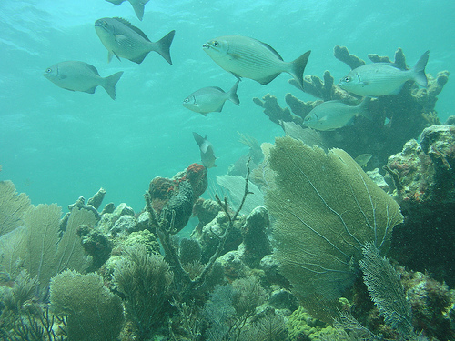
Hundreds of species of fish are present in the park's waters,
including more than fifty species of crustaceans ranging from isopods to
giant blue land crabs, some two hundred species of birds, and about 27
species of mammals, both terrestrial and marine. Molluscs include a
variety of bivalves, marine and land snails, sea hares, sea slugs, and
two cephalopods, the Caribbean reef octopus and the Caribbean reef
squid.
The sheltered open waters of the bay and the outlying
chain of keys provide resting areas for migratory birds on their way
between North America, the Caribbean islands, and South America. Many
land birds head south in the fall to Cape Bill Baggs State Park Florida,
just north of the park on Key Biscayne, before venturing across the open
waters of Biscayne Bay. Spring migrants toward the north do the same at
Elliott Key. The majority of small passerine migrants are warblers, with
hornets, palm warblers, American redstarts, common yellowthroats,
prairie warblers, worm-eating warblers, and black-throated blue warblers
accounting for the majority. Migrating raptors include hawk-tails.
short, sharp-shinned hawks, merlins, peregrine falcons and
swallow-tailed kites, while bald eagles and ospreys nest in the park.
Both white-tailed and red-tailed tropicals are seen in the park, as are
American flamingos, with some of the latter probably escaping captive
birds.
The coasts of the mainland are dominated by a marshy transition zone
mainly populated by red mangrove and black mangrove growing from the
shallows, with white mangrove growing further back from the water's
edge. The aerial root structure of the trees provides a protected
habitat for crabs, fish, and wading birds. Brown waters within mangroves
are nurseries for fish, molluscs, and crustacean larvae that require a
calm, protected environment before immature animals can disperse into
open water. Mangroves lose their leaves at about 2–4 short tons per acre
(4.5–9.0 t/ha) per year, the food supply for fish, worms, and
crustaceans. Because carbon in leaves is sequestered by uptake in
animals, mangroves are estimated to have two to three times the carbon
sequestration capacity of terrestrial forests. The mangrove forest in
Biscayne Bay is the largest in the east coast of Florida. Shoreline and
bayside mangrove island represent an important nursery for southeast
Florida marine life.
The salt-tolerant mangrove margin has
expanded inland as freshwater flow into the bay has been channelized,
replacing the freshwater sawgrass swamps. The coastal storm L-31E
increased inland from the western boundary of the park, it has played a
significant role in isolating the former freshwater marshes from their
water sources. At the same time, tidal water does not reach the interior
of the coastal margin, which limits the exchange between salt and
freshwater ecosystems.
Bird life on the coast includes
yellow-crowned night herons, loggerhead shrikes, prairie warblers and
shorebirds. Mangrove cuckoos, a notoriously hard-to-spot species, can be
seen at Convoy Point and Black Point. Biscayne has one of the largest
populations of mangrove cuckoos in Florida.
The fringes of the
park are habitat for the threatened American crocodile. The construction
of miles of water-cooling canals in the marl lands close to shore behind
the Turkey Point Power Plant, and the warm waters of the canals have
provided an almost ideal environment for crocodile nesting, making the
power plant a nursery for many who live in the park. Despite the fact
that American crocodiles and alligators both occur in the southern tip
of Florida, crocodiles are uncommon in Biscayne, as alligators mainly
they inhabit fresh waters further inland, while crocodiles may live in
somewhat saltier estuarine waters off Biscayne.
Open waters are inhabited by fish, mollusks, and crustaceans that
live in seagrass beds or prey on each other. The shallowness of the
lagoon makes it a suitable habitat for diving birds such as anhinga,
cormorants and diving ducks. The bay is also a habitat for juvenile
marine animals that have left the refuge of the mangrove belts. Manatees
frequent the calm waters of the bay.10 The bay has a year-round
population of double-crested cormorants. Winter residents include
gannets, American white pelicans, and common grebes. The bay also has a
resident population of common bottlenose dolphins.
Biscayne Bay
is a shallow lagoon with little vertical salinity or density gradient
due to its lack of depth. Instead of a vertical gradient, the bay shows
a horizontal density gradient, with fresh water entering from drainage
channels on the west side and seawater entering through lagoons in the
cays and through the section of the bay. sandbar safety valve. The
salinity of the bay reaches a peak in June. Changes in the salinity
pattern of the bay have had negative effects on previously abundant
species such as the red drum. Biscayne Bay and Florida Bay are major
nurseries for red grouper and gray snapper. The bottom of the lagoon
hosts sponges and soft corals where grasses may not grow. Three main
species of seagrass are found in the park: turtlegrass, shoal grass, and
manatee grass. The endangered Johnson's seagrass is also found in small
numbers in the bay, which is at the southern end of the grass's range.
Approximately 75 percent of the central floor of the bay is covered by
grasses. Scarring of seagrass beds from ship grounding or propellers is
a significant problem. Around 200 such incidents are documented each
year, with full regrowth requiring a maximum of 15 years. The bay is
also affected by commercial shrimp trawling, which is permitted in park
waters. The passage of roller-frame trawls does not harm grasses, but
damages soft corals and sponges.
Elliott Key is the largest island in the park, measuring 1,650 acres
(670 ha) and approximately 8.1 miles (13 km) long by 0.62 miles (1 km)
wide. Next largest is Old Rhodes Key at 660 acres (270 ha), then Sands
Key 420 acres (170 ha), Totten Key 380 acres (150 ha), and Little Totten
Key at 200 acres (81 hectares), with 37 smaller islands arranged in a
north-south line between 5 and 8.7 mi (8 to 14 km) east of the mainland
coastline. The cays change from barrier islands with rocky cores in the
north to the shelves rock coral in the south. All are surrounded by
mangroves, with vegetation and lush subtropical rainforests in the
interiors, including limbo gumbo, mahogany, ironwood, torchwood and
satinleaf. Insects include Schaus' swallowtail, an endangered species,
as well as dense clouds of mosquitoes in the rainy season, preyed on by
dragonflies. Marsh rabbits and raccoons, along with mice and rats
comprise the primary mammalian species. Reptiles include rattlesnakes
and a variety of lizards, as well as the occasional crocodile.
The cays are a transition area capable of harboring unexpected birds,
often Caribbean species that have strayed close to the mainland. The
interior of the keys are frequented by warblers and hawks that prey on
them. Coastal areas are a habitat for rufous turnstones and lesser
sandpipers. Gulls and terns include royal terns, black-headed gulls and
ring-billed gulls, with brown pelicans close to shore. Wilson's Plover
nests on Boca Chita Cay, where nesting grounds are closed during the
breeding season.
Sea turtles nest on the island's beaches in the
park. Park staff actively assist turtle nesting by removing debris from
the beaches that could present an obstacle to adults and hatchlings.
Loggerhead turtles are the most common sea turtle species and account
for almost all of the turtle nests in the park. Nesting sites are
identified by beach patrols in the morning daily and are protected by
mesh screens against from the predation of abundant population of
raccoons. Nest protection efforts have reduced predation from 100% of
disturbed nests per year to undisturbed nests in 2007, with a more usual
average of more than 50% nest disturbance in most years. In 2012 one
nest was found calm and protected, five partially disturbed nests were
protected, and one nest was destroyed by predators. The threatened
eastern indigo snake is also present on the island.
Rare and
threatened plant species from the islands include the Sargent cherry
palm and the prickly pear semaphore cactus (Consolea corallicola). The
cactus, which has been described as "nearly extinct", has been reduced
to around 20 individuals. A colonial population of 570 cacti was found
on an island in Biscayne Bay in 2001, making it the largest known
population of prickly pear semaphore cacti in the world. The only
natural population of the Sargent's palm grows on Elliott Key. Fewer
than 50 grew on the key in 1991. Despite efforts to propagate the plant,
there are currently 16 Sargent palms on Elliott Key, with approximately
123 bred on Long Key.
Two endangered butterflies, the Schaus
swallowtail (Papilio Aristodemus) and the Miami Blue, are found in the
park, especially on Elliott Key. In 2012, the United States Fish and
Wildlife (USFWS) authorized a capture and captive breeding program for
Schaus' swallowtail after only five of the butterflies were found by
surveyors in the park, up from 35 in 2011, out of a total surveyed
population of 41 Florida. The Miami Blye was feared extinct after
Hurricane Andrew in 1992, but a population was found in 1999 on Bahia
Honda Key. Captive breeding produced 25,000 Miami Blues, some of which
have been released on Elliott Key with mixed results.
Beyond the cays in the Atlantic Ocean the sea floor gradually slopes
downward before rising into an almost continuous coral reef. The reef,
made up of living corals, is inhabited by more than 200 species of fish,
as well as mollusks, crustaceans, and worms.69 Each species of coral in
park waters is considered protected by either federal or state
regulations. Coral reefs are estimated to cover about half of the park
area, with about 4,000 individual patch reefs and bank-barrier reef
areas. Hundreds of species of hard and soft corals, sea anemones, and
sponges are found in bay and ocean waters. Coral reefs can be further
subdivided into the outer reef at the edge of the Florida carbonate
shelf, the patch reefs between the reef and the cays, and the reefs in
the banks on each side of the keys. The reefs are dominated by elkhorn
coral at 10 meters (33 feet) water depth, and staghorn coral below 10
meters. Inland patch reefs are composed primarily of boulder star coral
and symmetrical brain coral. Shoal island reefs consist primarily of
lesser star coral and porous finger corals.
Reef environments in
Biscayne National Park have seen declines in species richness and
diversity across all fish species from 1977 to 1981 for the period
2006-2007. A sampling program showed declines at all sites Of sampling.
A correlation has been posited between the observed decline in coral
reef cover throughout the Florida Coral tract and declines in fish
species. Population declines were observed both in sport fishing and in
fish species not exposed to fishing pressure. The algae cover has
increased as the corals have reduced, so inhabiting coral species have
decreased, while herbivorous fish have increased. Increased global
salinity and changing salinity gradients in Biscayne Bay may also play a
role, while PCB and mercury contamination have been observed in fish
samples.
Reef environments in Biscayne National Park have seen
declines in species richness and diversity across all fish species from
1977 to 1981 for the period 2006-2007. A sampling program showed
declines at all sites Of sampling. A correlation has been posited
between the observed decline in coral reef cover throughout the Florida
Coral tract and declines in fish species. Population declines were
observed both in sport fishing and in fish species not exposed to
fishing pressure. The algae cover has increased as the corals have
reduced, so inhabiting coral species have decreased, while herbivorous
fish have increased. Increased global salinity and changing salinity
gradients in Biscayne Bay may also play a role, while PCB and mercury
contamination have been observed in fish samples.
The park's
eastern boundary lies just behind the rise of the coral reef at ten
fathoms (60 ft; 18 m) sea depth. Areas offshore are protected within the
Florida Keys National Marine Sanctuary, which extends east to a limit
corresponding to a depth of 300 fathoms (1,800 ft; 550 m). The coastal
waters are home to brown pelicans, magnificent frigatebirds , brown
boobies, particularly around offshore lights, and pelagic birds such as
shearwaters and petrels. Whales in offshore waters are rare, but may
include right whales, humpback whales, sperm whales, fin and fin whales.
sei, all of which are listed as endangered. The sawfish is equally rare
in park waters and is endangered. Threatened coral species include
elkhorn and staghorn, as well as pillar coral, listed as endangered in
Florida.
More than 50 species of exotic plants have been documented in the park, with almost 20 of which are considered pest species that can displace native plants and possibly upset the ecological balance. Green iguanas, cane toads, black rats, lionfish, fire ants, oscars and brown lizards are common in the park. The lionfish (Pterois volitans and Pterois milles) is a tropical fish of the Pacific-Indian Ocean area. It is known for its voracious appetite and its ability to establish itself in new waters, quickly replacing other species. Researchers theorized that the introduction of this species to the park occurred during Hurricane Andrew in 1992. Sightings in Biscayne Bay at that time are believed to have been from home aquariums that were destroyed during the hurricane, although the researcher who first proposed the theory has recanted the claim. More recent sightings of lionfish are likely from the more established populations in the Florida Keys, south of the park. Also likely originating from human captivity, Burmese pythons have been observed near the park's boundaries throughout the continent. Exotic plant species that pose the greatest risk to native plant communities include Brazilian pepper, torpedo grass, tuberous sword fern, guava, and portiatree.
Biscayne's tropical climate reflects its location at the southern tip
of Florida. Southern Miami-Dade County is classified as tropical
savannah in the Köppen-Geiger system.130 The seasons can be divided into
the dry season, from November to April, and the rainy season, from May
to October. Dry season temperatures average between 66 and 76 °F (19 and
24 °C) with an average monthly rainfall of 2.1 inches (53 mm). Rainy
season temperatures average between 76 and 85 °F (24 and 29 °C) with an
average monthly precipitation of 5.39 inches (137 mm). The rainy season
roughly coincides with the hurricane season, with frequent
thunderstorms.
Like many places in South Florida, Biscayne
National Park is affected by hurricanes every few years. Most storms
require temporary closures and occasional repairs to park facilities. A
direct hit by a powerful hurricane can have severe consequences,
particularly because of its impact on human interventions in the
environment rather than the park's natural environment, which is well
suited to these events. Major hurricanes reaching Biscayne include
storms in 1835 and 1904, the 1906 Florida Keys hurricane, the 1926 Miami
hurricane, the 1929 Bahamas hurricane, the 1935 Labor Day hurricane, the
1935 Yankee hurricane, the Florida Hurricane of 1941, the Southeast
Florida Hurricane of 1945, the Miami Hurricane of 1948, Hurricane Rey in
1950, Hurricane Donna in 1960, Hurricane Cleo in 1964, and Hurricane
Andrew in 1992. The park it can be affected by wave action from more
distant tropical storms such as 2012 Hurricane Sandy, which damaged
facilities on Elliott Key.
On August 24, 1992, Hurricane Andrew
made landfall just south of Miami, passing directly through Biscayne
National Park, with maximum sustained winds of 141 miles per hour (227
km/h), gusting to 169 mph. (272km/h). Storm surge was up to 17 feet (5.2
m) above mean sea level. It was a category 5 hurricane on the
Saffir-Simpson scale.137 Biscayne Bay was affected by scouring the
bottom and turbidity and with damage to its mangrove forest margins.
Leaking boats and damaged marinas contaminated the bay with fuel, with
continuous discharges for nearly a month after the hurricane struck. A
memorial plaque was placed at the Dante Fascell Visitor Center in 2002
to commemorate the environmental and human toll. Andrew, and to
celebrate the area's recovery from the effects of the storm. The
inscription reads in part:
On Monday, August 24, 1992, at 4:30
am, the eyewall of Hurricane Andrew passed over this point before
striking Homestead and southern Miami-Dade County.
The Fowey
Rocks Light Station transmitted weather data with peak winds at a
two-minute wind speed of 127 knots (235 km/h) and a gust to 147 knots
(272 km/h) before the station left to transmit, presumably due to damage
from stronger gusts. The strongest part of the eyewall had not been
reached at Fowey Rocks when broadcast ceased.
Since all park
lands are no more than a few feet above sea level, they are vulnerable
to sea level rise. The Park Service is projecting that much of the
park's acreage will be lost in the next two hundred years. Sea level in
Biscayne Bay is projected to rise between 3 and 7 inches (8 and 18 cm)
by 2030 , and 9 24 inches (23 to 61 cm) by 2060. A sea level rise of 3
to 6 inches (8 to 15 cm) is projected to increase saltwater intrusion
into the Biscayne Aquifer. If it rises higher it will turn the southern
Everglades into a saltwater lagoon, altering the ecology of the region.