Location: St. Simons Island, GA Map
Area: 241 acres (1 km²)
Tel. (912) 638- 3639
Constructed: 1736-
1748 by James Oglethorpe
Open: 9am- 5pm daily
Closed: Christmas
Day
Fort Frederica National Monument, located on St. Simons Island in Glynn County, Georgia, preserves the archaeological remnants of a mid-18th-century British colonial outpost that played a crucial role in the founding and defense of the Georgia colony. Established as a national monument on May 26, 1936, by President Franklin D. Roosevelt, and fully administered by the National Park Service (NPS) since September 10, 1945, the 250-acre (101 ha) site encompasses the ruins of Fort Frederica, the surrounding town of Frederica, and adjacent salt marshes along the Frederica River—a tributary of the Turtle River in the Golden Isles region. Designated to protect these historical features for public benefit and inspiration, the monument symbolizes the British-Spanish colonial rivalry in the American Southeast, particularly during the War of Jenkins' Ear (1739–1748) and the Battle of Bloody Marsh (1742), which secured Georgia against Spanish incursions from Florida. Today, it serves as an open-air museum of colonial archaeology, drawing around 200,000 visitors annually for its evocative ruins, interpretive programs, and natural beauty, while highlighting diverse colonial inhabitants including British soldiers, Scottish Highlanders, German Salzburgers, and enslaved Africans. As of September 2025, the monument operates without an entrance fee (a change implemented in recent years to encourage broader access), with the Visitor Center and grounds open daily from 9 a.m. to 5 p.m. (extended to sunset in summer), and no major disruptions reported following Hurricane Idalia's minor impacts in 2023.
Fort Frederica National Monument occupies a coastal barrier island
setting within the Georgia Bight—a broad curve of the Atlantic coastline
from Cape Fear, North Carolina, to Cape Canaveral, Florida—specifically
on the northern end of St. Simons Island, part of the Sea Islands
archipelago. The 250-acre site is bounded by the Frederica River to the
north and east, with expansive salt marshes extending southward and
westward, forming part of the 378,000-acre Guale coastal ecosystem—one
of the largest intact tidal marsh systems on the U.S. East Coast.
Elevations are low and flat, ranging from sea level to about 10–15 feet
(3–4.5 m), with sandy soils, maritime forests of live oaks draped in
Spanish moss, and palmetto understories dominating the upland areas
around the fort ruins.
Geologically, the monument sits on
Holocene-age (less than 10,000 years old) barrier island deposits of
quartz sand and shell fragments, formed by rising sea levels after the
last Ice Age that submerged ancient shorelines and created the modern
coastal plain. Underlying strata include Pleistocene limestone and
Miocene sediments from the Tertiary period, exposed in nearby bluffs but
not prominently within the site. The barrier islands, including St.
Simons, are dynamic features shaped by longshore currents, storms, and
tidal action, with the Frederica River's brackish estuary influencing
sediment deposition and erosion. The surrounding salt marshes—4 to 6
miles wide and among the most productive ecosystems globally—act as
natural buffers against hurricanes and sea-level rise, filtering
nutrients and stabilizing the coastline. Climate is humid subtropical,
with mild winters (average 50°F/10°C), hot summers (85°F/29°C), and 50
inches (127 cm) of annual rainfall, making it vulnerable to tropical
storms like those in 2016 (Matthew) and 2017 (Irma), which caused minor
flooding but no significant structural damage to the ruins.
Fort Frederica's history is a microcosm of British colonial ambitions
in the New World, rooted in the founding of Georgia as a buffer against
Spanish Florida and a haven for debtors and religious refugees.
Founding and Construction (1733–1736)
In 1733, James Edward
Oglethorpe, founder of the Georgia colony, selected St. Simons Island
for its strategic location to counter Spanish threats from St.
Augustine. He established Fort St. Simons (later renamed Fort Frederica
in honor of Frederick, Prince of Wales) in 1736, naming the town after
the river and fort. The site was chosen for its defensible position on a
bluff overlooking the Frederica River, with construction involving
British soldiers, Scottish Highlanders (e.g., the 42nd Regiment), German
Salzburgers (Protestant refugees), and enslaved African laborers—up to
1,000 residents by 1740, including free Blacks and indentured servants.
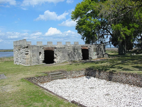
The fort was a tabby (oyster-shell concrete) and timber structure with
barracks, a powder magazine, guardhouse, and walls enclosing the town,
which featured a church, bakery, watch house, and homes—planned as a
grid with a central parade ground.
Key Events and the Battle of
Bloody Marsh (1739–1742)
Tensions escalated with the War of Jenkins'
Ear (1739), prompting Oglethorpe to fortify Frederica as the colony's
military hub. In 1742, Spanish forces under Governor Antonio de
Arredondo invaded from Florida, landing 5,000 troops on St. Simons.
Oglethorpe's 600 defenders, aided by Creek allies, ambushed the Spanish
at the Battle of Bloody Marsh (July 7, 1742), using scorched-earth
tactics and musket fire from hidden positions to rout the invaders,
killing over 200 Spaniards and securing British control. This victory,
exaggerated in British propaganda, deterred further invasions and
solidified Georgia's borders until the 1763 Treaty of Paris ended the
Seven Years' War.
Decline and Abandonment (1743–1758)
After
1743, with threats subsided, the British regiment disbanded in 1749,
leading to economic decline as settlers departed for Savannah. The town
dwindled to a few hundred residents, ravaged by disease (yellow fever in
1755) and fires, culminating in a devastating blaze on April 8, 1758,
that destroyed most wooden structures, leaving only the tabby fort and
ruins. By the American Revolution (1775–1783), the site was abandoned
and overgrown, used sporadically as a plantation before erosion and
development threatened the ruins in the 20th century.
Preservation and Significance
Archaeological excavations began in the
1930s under the NPS, uncovering foundations, artifacts (pottery,
buttons, coins), and graves—over 50 burials, including
children—revealing a multicultural society. The monument's significance
lies in its representation of colonial defense, multicultural Georgia
(one of the most diverse early settlements), and the shift from military
outpost to archaeological treasure, listed on the National Register of
Historic Places in 1966.
Fort Frederica's ecology is emblematic of Georgia's coastal barrier
islands, integrating human-modified landscapes with resilient tidal
systems. The monument protects 250 acres of maritime forest, salt marsh,
and estuarine habitats within the larger 378,000-acre Guale ecosystem,
one of the East Coast's most productive wetlands. Upland areas feature
live oak, slash pine, and southern red cedar canopies with understories
of yaupon holly, wax myrtle, and saw palmetto, supporting over 300 plant
species adapted to sandy, saline soils. The salt marshes—dominated by
cordgrass (Spartina alterniflora) and black needlerush—span thousands of
acres adjacent to the site, filtering pollutants, preventing erosion,
and serving as nurseries for shrimp, crabs, and fish that sustain
Georgia's $2.5 billion seafood industry.
Wildlife is diverse and
migratory: Over 300 bird species, including painted buntings,
prothonotary warblers, and bald eagles, thrive in the forests and
marshes; wading birds like great blue herons and egrets forage in tidal
creeks. Mammals include white-tailed deer, river otters, armadillos, and
bobcats; reptiles such as diamondback rattlesnakes, gopher tortoises (a
species of concern), and alligators inhabit the wetlands; and marine
life features bottlenose dolphins and manatees in the river. The
monument's barrier island position makes it a stopover for neotropical
migrants during spring and fall, with the marshes acting as storm
buffers—vital amid climate change, as sea-level rise (3 mm/year locally)
threatens inundation. NPS monitors invasives like feral hogs and
hydrilla, using prescribed burns to maintain habitat diversity.
Fort Frederica offers low-key, interpretive recreation focused on
history and nature, appealing to families, hikers, and birders. There is
no entrance fee, a policy enhancing accessibility since its
implementation. The Visitor Center (6515 Frederica Road, St. Simons
Island) is open daily 9 a.m.–5 p.m. (grounds until sunset), featuring
exhibits, a 20-minute film on the battle, and a museum store; ranger
programs (included, daily in summer) include guided tours of the ruins,
talks on Oglethorpe, and living history demos.
Activities include a
1.5-mile self-guided walking tour along a paved path through the ruins
(wheelchair-accessible), passing the fort's tabby walls, barracks
foundations, and the town bakery; birdwatching from observation decks
(peak migration October–April); and picnicking in shaded areas. No
camping or boating, but nearby state parks offer those; pets are allowed
on leashes but not in buildings. Accessibility includes ramps at the
fort entrance and audio descriptions via app. In 2025, updates include
expanded Junior Ranger programs for kids and virtual tours online;
events like the annual Bloody Marsh Battle Reenactment (July) draw
crowds, with 2025 emphasizing multicultural stories. Visitor reviews
praise the serene atmosphere and educational value, rating it 4.5/5 on
platforms like TripAdvisor, though some note limited shade in summer.
Administered by the NPS under the Organic Act of 1916 and the
Historic Sites Act of 1935, Fort Frederica is managed to preserve its
archaeological integrity, cultural resources, and natural habitats for
public enjoyment. The 1936 enabling legislation authorized up to 80
acres (expanded to 250), allowing land donations, purchases, and
condemnation for protection, with a museum for artifacts and monuments
for commemoration. Listed on the National Register of Historic Places
(1966) and a National Historic Landmark, it benefits from the Friends of
Fort Frederica (FoFF), a 501(c)(3) nonprofit supporting preservation
through funding, advocacy, and events.
Conservation focuses on
stabilizing ruins (e.g., tabby mortar repairs against humidity and salt
air), vegetation management (prescribed burns for marsh health), and
invasive species control, guided by the 2012 General Management Plan
(under review in 2025 for climate resilience). Challenges include
sea-level rise (threatening marshes), erosion from storms, and tourism
impacts, addressed via partnerships with the Georgia Department of
Natural Resources and NOAA for monitoring. The 2025 Superintendent's
Compendium outlines closures (e.g., no digging) and permits for events.
Recent developments include enhanced archaeological surveys (2024 lidar
mapping) and FoFF-funded exhibits, ensuring the site's legacy as a
testament to colonial America's multicultural foundations endures.