Location: St. Johns County, FL Map
Constructed: 1740-42
Area: 227.76 acres (0.91 km²)
Fort Matanzas National Monument is a historic coastal preserve encompassing 300 acres in St. Johns County, Florida, just 14 miles south of St. Augustine's Castillo de San Marcos along the Atlantic shoreline. Proclaimed a national monument on October 15, 1924, by President Calvin Coolidge, it safeguards a small 18th-century Spanish coquina stone watchtower—Fort Matanzas—built in 1742 to defend the southern flank of Spain's colonial capital at St. Augustine from British incursions. The name "Matanzas" derives from the Spanish word for "slaughters," commemorating the 1565 massacre of French Huguenots by Spanish forces under Pedro Menéndez de Avilés in the nearby inlet. Managed by the National Park Service (NPS), the monument not only preserves this architectural relic of colonial warfare but also protects a fragile barrier island ecosystem, including dunes, salt marshes, maritime hammocks, and tidal creeks that serve as critical habitat for migratory birds and sea turtles. Unlike larger parks, its compact scale emphasizes interpretive history and low-impact nature exploration, drawing about 500,000 visitors annually—many as a complement to nearby Castillo de San Marcos. The site embodies the turbulent clash of European empires in the New World, while its coastal setting highlights ongoing environmental vulnerabilities like erosion and sea-level rise.
The monument's history is inextricably linked to the geopolitical
struggles of colonial Florida. The Matanzas Inlet, a treacherous
waterway south of St. Augustine, became infamous in 1565 when
Menéndez de Avilés ambushed and executed over 200 French Protestants
who had shipwrecked there, securing Spanish dominance in La Florida.
This event, combined with later threats, underscored the inlet's
strategic vulnerability as an alternative route for attackers
bypassing St. Augustine's northern defenses.
By the early 18th
century, Spain faced escalating pressure from British Carolina
colonists. In 1740, during the War of Jenkins' Ear, British forces
under James Oglethorpe besieged St. Augustine but failed to capture
it, retreating southward through the unguarded Matanzas Inlet. This
near-miss prompted Spanish Governor James Oglethorpe to order
construction of a defensive outpost in 1740. Under military engineer
Pedro Ruiz de Olano, laborers quarried coquina—a porous shellstone
from nearby Anastasia Island—and erected the modest fort by 1742 at
a cost of about 2,500 pesos. Garrisoned by a sergeant and six
soldiers, it featured a watchtower for spotting vessels, with cannon
fire intended to sink ships in the shallow inlet. The fort repelled
a brief British probe in 1743 but saw little action thereafter, as
Spain ceded Florida to Britain in 1763 under the Treaty of Paris.
The British briefly occupied it as Fort Howlin before returning it
to Spain in 1783. After the U.S. acquired Florida in 1821, the fort
fell into disuse, serving sporadically as a lighthouse signal
station and fishing camp before abandonment.
The site's
preservation began in the 1920s amid growing interest in Florida's
Spanish heritage. Local civic groups, including the St. Augustine
Historical Society, advocated for federal protection to prevent
vandalism and erosion. President Coolidge's 1924 proclamation
established it as one of the earliest national monuments focused on
colonial military history, administered initially by the War
Department before transferring to the NPS in 1933. Early efforts
included stabilization by the Civilian Conservation Corps in the
1930s, which cleared overgrowth and repaired walls. Designated a
National Historic Landmark in 1960, it integrates with the broader
Colonial Spanish National Historical Park network.
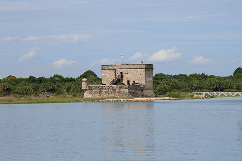
Fort Matanzas exemplifies pragmatic Spanish colonial military
architecture, designed for defense in a subtropical environment
rather than grandeur. The structure is a compact, two-story masonry
tower rising 30 feet, measuring about 60 feet square at the base
with walls up to 9 feet thick, constructed from locally quarried
coquina blocks mortared with lime and tabby (oyster shell concrete).
This material, soft when wet but hardening like limestone, provided
resilience against cannon fire while blending with the coastal
landscape. The ground floor housed a powder magazine, storerooms,
and barracks for the small garrison, accessible via a drawbridge
over a dry moat. The upper story featured a gun deck with embrasures
for four 8-pounder cannons, offering 360-degree views over the
inlet, and a captain's room with a tiled roof and wooden shutters. A
watchtower atop the parapet allowed sentries to signal St. Augustine
via flags or bonfires.
The design prioritized functionality:
narrow embrasures minimized exposure, while the site's elevated
position (about 20 feet above high tide) deterred amphibious
assaults. Post-construction additions included a wooden wharf for
supply boats, now gone. Unlike the ornate Castillo de San Marcos,
Fort Matanzas was a "watchtower" outpost—simple, austere, and manned
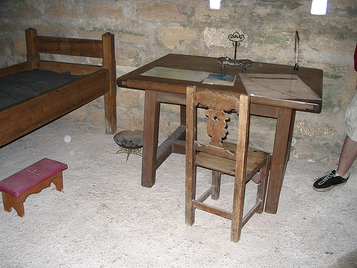
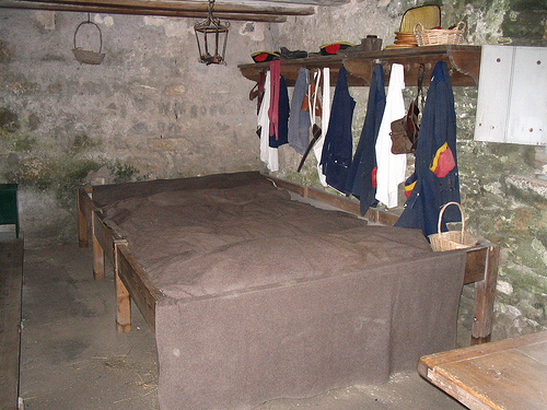
minimally, reflecting Spain's resource constraints. Today, restored
interiors display period artifacts like iron grates and musket
rests, with interpretive panels explaining daily life: soldiers
endured isolation, disease, and hurricanes, subsisting on salted
meat and hardtack.
Situated on the northern end of Rattlesnake Island within the
Intracoastal Waterway (coordinates: 29.70° N, 81.24° W), Fort
Matanzas occupies a dynamic barrier island system influenced by
Atlantic tides, storms, and subtropical climate (average 60 inches
annual rainfall, temperatures 50–90°F). The monument's 300 acres
span salt marshes, oyster bars, and shifting dunes backed by
maritime oak hammocks and slash pine forests, forming a mosaic
shaped by aeolian (wind-driven) and marine processes. The Matanzas
Inlet, a federally designated wild and scenic river segment, bisects
the area, channeling tidal flows that flush nutrients into the
ecosystem. Sea levels have risen 8 inches since 1924, accelerating
erosion and inlet migration, which has threatened the fort's
foundation—once 200 feet from the water, now perilously close.
The geography reflects Florida's coastal geomorphology: sandy
beaches transition to interdunal swales supporting sea oats and
railroad vines, while interior wetlands filter pollutants from
upstream development. This barrier island buffers mainland St.
Augustine from storms, absorbing wave energy and preventing
saltwater intrusion into freshwater aquifers.
Fort Matanzas teems with coastal biodiversity, serving as a waypoint in the Atlantic Flyway for over 300 bird species, including migratory shorebirds like willets, oystercatchers, and royal terns nesting on dunes. Resident waders—great egrets, little blue herons, and wood storks (federally threatened)—forage in marshes teeming with fiddler crabs, shrimp, and menhaden. The monument protects critical habitat for sea turtles: loggerheads (threatened) and green turtles (endangered) nest on beaches from May to October, with NPS-monitored nests yielding hundreds of hatchlings annually. Mammals include raccoons, armadillos, and river otters in tidal creeks, while reptiles like American alligators and diamondback terrapins thrive in brackish waters. Flora features resilient salt-tolerant species: black needlerush in marshes, sea grapes and cabbage palms in hammocks, and endangered plants like the golden leatherfern on shaded bluffs. Invertebrates abound, with horseshoe crabs and blue crabs supporting the food web. The site's intact habitats contrast with surrounding development, but invasives like Brazilian pepper and feral hogs pose challenges.
Visitors experience Fort Matanzas through a blend of history and
nature. The main attraction is the 15-minute ranger-narrated ferry
ride (every 30–45 minutes, weather permitting) from the visitor
center to the fort island, where 30–45-minute guided tours explore
the structure's interiors and battlements (ferry operates 8:30
a.m.–3:30 p.m., last departure 3:15 p.m.). Self-guided options
include a 0.5-mile nature trail at the visitor center through
hammocks and marshes, ideal for birdwatching and photography, and a
1-mile beach walk to the fort's ruins (tide-dependent). Ranger
programs, such as cannon firings and living history demos, run
weekends and holidays; Junior Ranger badges engage kids with
activities on colonial life and ecology.
No entrance fee, but a
$15 per adult ferry ticket (free for under 16, America the Beautiful
passholders) covers round-trip access; reservations recommended via
recreation.gov, especially spring weekends when crowds peak. The
visitor center (8635 A1A South, St. Augustine, FL 32080;
904-471-0116) opens daily 9 a.m.–5 p.m. (closed Thanksgiving,
Christmas), featuring exhibits, a film, and restrooms. Access: From
St. Augustine, drive south on A1A 14 miles; parking is ample but
fills early. The fort island has no facilities—use restrooms before
ferrying. Pets prohibited on ferry and trails; accessibility
includes a wheelchair lift on the boat, but the fort's stairs limit
interior access. As of September 2025, operations are normal
post-2024 hurricane closures, with enhanced storm preparedness.
Fort Matanzas confronts acute coastal threats: accelerating
sea-level rise (projected 2–6 feet by 2100) erodes dunes and
undermines the fort's coquina walls, with inlet migration claiming
10–20 feet of shoreline annually. Storms like Hurricane Irma (2017)
and Idalia (2023) have battered the site, while upstream development
introduces pollutants and alters freshwater inflows, stressing
marshes. Invasive species degrade habitats, and visitor impacts
(litter, trampling) compound erosion. Broader concerns include
potential exhibit reviews under 2025 executive orders targeting
"divisive" historical narratives on colonialism and slavery.
Conservation is proactive: NPS invests in shoreline stabilization,
with $800,000 allocated in 2025 for dune restoration and living
shorelines using oyster reefs and native plants. The 2025 beach ramp
repair project, completed by July, improved pedestrian access while
minimizing flood risks. Partnerships with the National Parks
Conservation Association and Florida Fish and Wildlife monitor
turtle nests and remove invasives, restoring 50 acres since 2020.
Prescribed burns maintain hammocks, and the monument participates in
the NPS Climate Change Response Program for adaptive strategies like
elevating boardwalks. Recent news highlights resilience:
post-Hurricane Helene preparations in 2024 ensured minimal damage.
With federal funding from the Inflation Reduction Act and community
support, Fort Matanzas is poised to endure, evolving as a model for
integrating cultural preservation with climate adaptation in
vulnerable coastal parks.