Location: Alabama Map
Area: 13,633 acres (55.17 km2)
Little River
Canyon National Preserve is a stunning 13,534-acre protected
area in the Appalachian foothills of northeast Alabama,
straddling DeKalb and Cherokee counties near Fort Payne.
Established on October 21, 1992, as a unit of the National Park
System under Public Law 102-427, it safeguards one of the
deepest canyons east of the Mississippi River—plunging up to 600
feet deep and spanning 3,000 feet wide in places—carved by the
free-flowing Little River, which remarkably courses along the
mountaintop for most of its 45-mile length atop Lookout
Mountain. This unique geological feature creates a dramatic
landscape of sheer sandstone cliffs, thundering waterfalls,
crystal-clear pools, boulder-strewn rapids, and lush forested
rims, earning it the nickname "Grand Canyon of the East." The
preserve not only preserves exceptional scenic beauty and
biodiversity but also cultural heritage, including Native
American sites and Civil War remnants, while offering accessible
outdoor recreation. Managed by the National Park Service (NPS)
in partnership with the U.S. Forest Service's Alabama National
Forest and local entities like Jacksonville State University, it
attracts around 100,000 visitors annually for hiking,
birdwatching, and scenic drives. As a national preserve rather
than a park, it allows compatible activities like limited
hunting and grazing, balancing conservation with traditional
uses. Its ecological significance lies in protecting rare
endemic species and serving as a vital watershed for the Weiss
Lake system, contributing to regional water quality and flood
control.
The human story of Little River Canyon is as layered as its geology,
spanning millennia of indigenous habitation, colonial settlement,
industrial exploitation, and modern conservation. For thousands of
years, the area was home to Native American peoples, including the
Cherokee and Creek (Muscogee) nations, who revered the canyon as a
sacred landscape for hunting, fishing, and spiritual practices.
Archaeological evidence reveals ancient villages, petroglyphs, and trade
routes along the river, with the Cherokee Trail of Tears passing nearby
in the 1830s, marking a tragic chapter of forced relocation. European
settlers arrived in the early 19th century, drawn to the fertile valleys
for farming and timber, but the rugged canyon terrain limited widespread
development.
By the late 1800s and early 1900s, the region faced
intense pressures from logging, mining (for iron ore and coal), and
quarrying, which scarred the landscape and threatened water quality. The
canyon's isolation preserved some wildness, but post-World War II
suburban sprawl and recreational demands— including illegal dumping and
off-road vehicle abuse—prompted calls for protection. Local advocates,
including the DeKalb County Chamber of Commerce and conservationists
like the Southeastern Flower Show, lobbied Congress in the 1980s. In
1992, bipartisan legislation signed by President George H.W. Bush
created the preserve, acquiring 9,500 acres from private owners and
incorporating adjacent federal lands, with the U.S. Forest Service
retaining management of about 3,000 acres. This "one land, many uses"
model reflected compromises with locals, allowing continued access for
hunting and fishing.
The preserve's cultural narrative includes Civil
War skirmishes (e.g., the 1864 Battle of Dug Gap) and 20th-century
moonshining lore. Today, interpretive programs at the Little River
Canyon Center highlight these stories, and the site's 30th anniversary
in 2022 featured exhibits on indigenous resilience. As of 2025, ongoing
partnerships with the Cherokee Nation emphasize cultural stewardship.
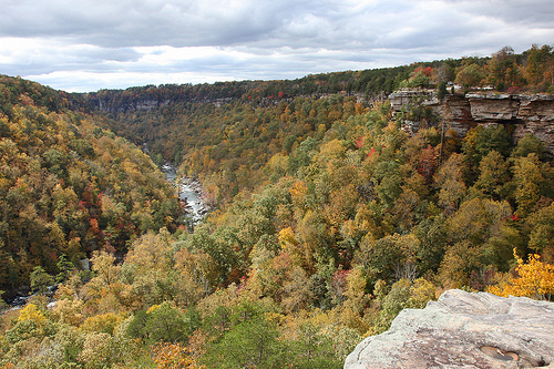
Perched on the Cumberland Plateau's edge in the Southern Appalachians
(coordinates: 34.38° N, 85.68° W), Little River Canyon National Preserve
occupies a transitional zone between the Appalachian highlands and the
Gulf Coastal Plain, with elevations ranging from 600 to 1,900 feet. The
canyon itself, formed over 200 million years by erosion of ancient
sandstone layers (part of the Pennsylvanian Pottsville Formation),
stretches 12 miles from DeSoto State Park in the north to the "Canyon
Mouth" near Gaylesville in the south. The Little River, undammed and
spring-fed, meanders atop the mountain, plunging dramatically into
gorges via waterfalls like the 104-foot De Soto Falls and Little Falls
(45 feet), creating habitats from turbulent whitewater to serene pools.
Hydrology is influenced by subtropical rainfall (50–60 inches annually),
with flash floods sculpting solution holes and undercut bluffs.
Ecosystems form a vertical mosaic shaped by fire, water, and
microclimates:
Canyon Floor and Riparian Zones: Shaded by towering
cliffs, these humid areas host ferns, mosses, and riverine forests of
sycamore, river birch, and black walnut. Boulder fields and gravel bars
support algae and invertebrates.
Mid-Slope and Bluffs: Steep talus
slopes feature rock outcrops with drought-tolerant lichens, sedges, and
endemic herbs. Hemlock groves (threatened by woolly adelgid) line shaded
ledges.
Rim and Uplands: Mixed hardwood-pine forests dominate
sandy-loam soils, with oak-hickory canopies giving way to open longleaf
pine savannas maintained by prescribed burns. Prairies and heath balds
add diversity.
The preserve's geology—sandstone caprock over
shale—creates natural arches and seeps, fostering high endemism. It's a
biodiversity hotspot in the Ridge and Valley ecoregion, with over 900
vascular plant species, including 38 rare ones.
Little River Canyon's isolation has nurtured a remarkable array of
species, with 39 state-listed rare plants and animals, making it a key
refuge in Alabama's biodiversity. The preserve supports a classic
Appalachian assemblage, enhanced by the canyon's thermal refugia and
unpolluted waters.
Aquatic life thrives in the river's oligotrophic
(nutrient-poor) waters: the federally threatened Alabama canebrake
crayfish (Faxonius erichsoni) clings to rocky substrates, while the
snail darter (Percina tanasi, federally endangered) and southern
redbelly dace (Notropis lutrensis) navigate riffles. Amphibians like the
green salamander (Aneides aeneus) and seal salamander (Desmognathus
monticola) inhabit seeps, and reptiles include the rare eastern slimy
salamander and black rat snake.
Birds number over 180 species, with
neotropical migrants like the Louisiana waterthrush and cerulean warbler
breeding in the canopy; raptors such as peregrine falcons nest on cliffs
(reintroduced successfully). Mammals include white-tailed deer, bobcats,
river otters, and the occasional black bear or gray fox. Insects buzz in
summer, with damselflies along the river and rare butterflies like the
Diana fritillary.
Flora highlights include the federally threatened
Cumberland rosemary (Conradina verticillata), a mint-family shrub on
shale outcrops; the green pitcher plant (Sarracenia oreophila,
endangered) in boggy prairies; and flame azaleas blooming vibrantly in
spring. The 2025 BioBlitz event (April 9–12) aims to catalog new
species, building on past discoveries of endemics. Invasive threats like
Japanese stiltgrass and hemlock woolly adelgid challenge natives, but
the preserve's intact habitats bolster resilience.
Little River Canyon beckons adventurers with low-impact pursuits
emphasizing its wild beauty. The 23-mile Canyon Rim Drive (County Road
275) offers pullouts for overlooks like Eagle Point and High Falls, with
panoramic views rivaling the Southwest. Hiking spans 20+ miles of
trails: the strenuous 3.8-mile round-trip Eberhart Point Trail descends
600 feet to the canyon floor via 300 steps, revealing pools and ferns;
easier options include the 1-mile Boardwalk Trail at the Little Falls
Overlook and the 2-mile Jones Gap Trail for wildflowers. Rock climbing
and rappelling (permit required) access sheer walls up to 200 feet,
while kayaking or tubing the river (Class I–III rapids) provides
thrills—launch from Lee’s Chapel in summer.
Birdwatching peaks in
migration (April–May, September–October), with hotspots at the canyon
mouth; fishing for smallmouth bass and trout requires an Alabama
license. Picnicking and photography abound at shaded sites, and mountain
biking is allowed on forest roads. No developed camping exists within
the preserve, but primitive sites are nearby in DeSoto State Park;
backcountry permits are needed for overnight hikes.
Visitor info: No
entrance fee; open daily from daylight to dusk. The NPS Visitor Center
at Jacksonville State University's Little River Canyon Center (375
College Street, Fort Payne) operates Tuesdays–Saturdays, 10 a.m.–4 p.m.
Central Time, offering exhibits, Junior Ranger programs (free badges for
kids), and maps. Directions: From I-59, exit 222 to US-35 north 12
miles; GPS works but signal is spotty. Address: 4322 Little River Trail
NE, Suite 100, Fort Payne, AL 35967; phone: 256-845-9605. Safety: Flash
floods, steep drops, and poison ivy pose risks—check weather, stay on
trails, and carry water (summers hit 90°F+). Pets on 6-foot leashes;
BARK Ranger program available. Events in 2025 include the BioBlitz
(April 9–12) for citizen science and guided wildflower hikes in spring.
Accessibility: Wheelchair-friendly overlooks and boardwalks.
Despite protections, Little River Canyon grapples with modern perils
amplified by climate change. Primary threats include upstream
development eroding water quality (sedimentation from agriculture and
urbanization), invasive species (e.g., privet, kudzu, and the hemlock
woolly adelgid decimating old-growth hemlocks), and habitat
fragmentation from roads and recreation. Illegal dumping, overfishing,
and poaching of rare crayfish persist, while acid mine drainage from
historic sites lingers. Climate projections warn of intensified droughts
stressing endemic plants and altered flood regimes disrupting aquatic
habitats. The canyon's role in regional carbon sequestration is vital,
but wildfires (exacerbated by drought) threaten upland forests.
Conservation is proactive and collaborative. The NPS, in tandem with the
Friends of Little River Canyon (a nonprofit founded in 1993), conducts
prescribed burns to restore pine savannas and invasive removal projects,
restoring 500 acres annually. The 2016 Foundation Document guides
management toward ecosystem resilience, emphasizing watershed
protection. Federal funding via the Inflation Reduction Act supports
restoration, including invasive fish control analogs for local streams.
The Youth Conservation Corps (YCC) program runs May 31–July 31, 2025,
engaging teens in trail maintenance and habitat work. The April 2025
BioBlitz, partnering with SciStarter and experts, will inventory species
to inform priorities. Long-term, the preserve integrates with the
Alabama National Forest for corridor connectivity, aiding species like
the cerulean warbler. With vigilant monitoring—via USGS partnerships for
water quality—and community education, Little River Canyon stands poised
to endure as a biodiversity stronghold and economic driver for northeast
Alabama, potentially expanding protections amid growing ecotourism.