Located: Moab, Utah Map
Area: 76,679 acres (31,031 ha)
Info: (435) 259 8161
Area: 76,519 acres
Open: Apr- Oct 7:30am- 6:30pm
Nov- Mar 8am- 4:30pm
When to go: spring- fall
What to see:
Delicate Arch at sunset
Hike Devil's Garden Trail to Landscape arch
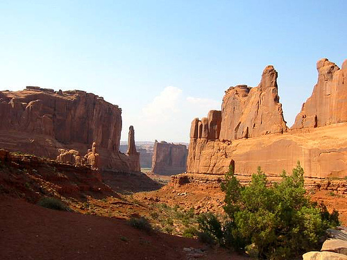
Arches National Park lies near Moab, Utah in United States. It
covers an area of 76,679 acres (31,031 ha). The park is a monument
to nature’s beauty. Arches National Park is famous for its amazing
natural arches that were carved by centuries of erosion through
action of water and wing. In total there are over 2000 different
arches on its territory. The number is approximate because no one
really knows for sure. Total area of Arches National Park is 309
square meters. The nature reserved is situated at an elevation of
1245- 1723 meters above sea level. During Mesozoic period (aka Age
of Dinosaurs) these lands were covered by a sea. Sandstone that
formed around that period (about 150 million years ago) was fairly
soft. Upon exposure to air after the sea receded it began to waver
away.
Few artifacts were found within boundaries of the
Arches National Park. They yielded little information about first
human settlements in this area, however you can still find
Petroglyphs and carvings that indicate presence of native tribes.
Most carvings that you can see here belong to a modern man and
doesn't impress neither with conveyed information nor particular
intelligence.
Most of arches and other famous formations in
the Arches National Park are easily accessible by foot. Many of them
are located next to parking spaces, so you don't need a long time to
get to them. However climbing and free climbing on natural
formations within Arches National Park is prohibited and punishable
by law. That is something hikers have to take in consideration.
Other features in the park are open for climbing, but you will need
a permit for that. Take plenty of water and avoid stepping of the
trails. Even seemingly empty spaces of sand are actually covered by
thin layer of plants and microorganisms that form a kind of crust.
It takes years to form and develop, but can take only few seconds
destroy them.
Park entrance fees are $10 for private vehicles
and $5 for individuals on foot, bike, or motorcycle. These fees
allow entrance for seven days.
There are several passes for
groups traveling together in a private vehicle or individuals on
foot or on bike. These passes provide free entry at national parks
and national wildlife refuges, and also cover standard amenity fees
at national forests and grasslands, and at lands managed by the
Bureau of Land Management and Bureau of Reclamation. These passes
are valid at all national parks including Arches National Park:
The $80 Annual Pass (valid for twelve months from date of issue)
can be purchased by anyone. Military personnel can obtain a free
annual pass in person at a federal recreation site by showing a
Common Access Card (CAC) or Military ID.
U.S. citizens or
permanent residents age 62 or over can obtain a Senior Pass (valid
for the life of the holder) in person at a federal recreation site
for $80, or through the mail for $90; applicants must provide
documentation of citizenship and age. This pass also provides a
fifty percent discount on some park amenities. Seniors can also
obtain a $20 annual pass.
U.S. citizens or permanent residents
with permanent disabilities can obtain an Access Pass (valid for the
life of the holder) in person at a federal recreation site at no
charge, or through the mail for $10; applicants must provide
documentation of citizenship and permanent disability. This pass
also provides a fifty percent discount on some park amenities.
Individuals who have volunteered 250 or more hours with federal
agencies that participate in the Interagency Pass Program can
receive a free Volunteer Pass.
4th graders can receive an Annual
4th Grade Pass that allows free entry for the duration of the 4th
grade school year (September-August) to the bearer and any
accompanying passengers in a private non-commercial vehicle.
Registration at the Every Kid in a Park website is required.
In
2018 the National Park Service will offer four days on which entry
is free for all national parks: January 15 (Martin Luther King Jr.
Day), April 21 (1st Day of NPS Week), September 22 (National Public
Lands Day), and November 11 (Veterans Day weekend).
If the
entrance booth is not manned, there is an electronic kiosk to pay
the entrance fee and receive a receipt to place on your vehicle's
dashboard.
The Colorado Plateau is an uplift created as a bulge by lateral
tectonic forces. The park is at an average of 1499 m above sea level,
its highest point is the "Elephant Butte" in the east at 1696 meters.
The lowest point in the park is 4,000 feet to the south on the Colorado
River, near the park entrance and visitor center. The south of the park
is characterized by canyon-like watercourses that are dry almost all
year round, the rest of the area is a high plateau crossed by several
flat and wide valleys.
Climatically, the area is a desert. In
summer, temperatures can reach 40°C, while in winter they can drop to
-10°C. Fluctuations of more than 25 °C within a day are not uncommon.
The long-term average of precipitation is below 200 mm. The low rainfall
is due to its proximity to the Tropic of Cancer, its high elevation
leading to prior rain at the Colorado Plateau borders, and its inland
location resulting in an extreme continental climate.
The stone arches that have protected the area and are the main
attraction of the national park are openings in rock ridges formed by
erosion without the involvement of flowing water. They are thus
delimited by natural stone bridges.
shift sequence
The high
concentration of stone arches in the park area of 310 km² can be
explained by the geology of the region. About 300 million years ago in
the late Pennsylvania, which belongs to the Palaeozoic era, a
saltwater-filled basin called the Paradox Basin was located on the site
of today's park. In the then hot and dry climate, salt settled in the
basin when the water evaporated. Over several hundred thousand years,
the basin must have been filled with new salt water again and again, as
a result the up to 1500 m thick Paradox Formation formed from a layer of
salt, which is traversed by marl, clay, anhydrite and individual
occurrences of slate. It was covered by the Honaker Trail Formation of
both limestone and sandstone. The latter was formed from erosion
products of the eastern Uncompahgre Mountains, a predecessor of the
Rocky Mountains. It is only exposed at one point in the south of the
park.
The Paradox Basin area largely lacks the Permian-Triassic
rock strata from about 300 to 200 mya that characterize the Grand
Staircase strata elsewhere on the Colorado Plateau; they were locally
worn away by intermittent erosion. Only isolated deposits of the Cutler
Formation from the Permian and the Moenkopi Formation as well as the
Chinle Formation of the Triassic are present. Only thin layers have
survived from the beginning of the Jurassic around 200 million years
ago. They were formed from sand dunes that, driven by the wind, covered
the newly exposed salt layers and were compressed over a geologically
long time to form the Wingate sandstone under the pressure of later
layers. In a few places it is overlain by a thin layer of Kenyata
sandstone, deposited as sands from alluvial fans. The layer of Navajo
sandstone is significant. It was formed from the compaction of dunes
driven together by the wind. The resulting round shapes with overlapping
structures of alternating directions can be observed almost everywhere
in the park on the immediate surface of the earth.
By 150 mya at
the end of the Jurassic it was again covered by heterogeneous sandy
sediments that became the Entrada Sandstone Formation. Their lowest
layer is called the Dewey Bridge Member, above that is the Slick Rock
Member. Together they are referred to as the Carmel Formation. Above
that is the Moab Member from the Curtis Formation. All of the park's
stone arches are eroded from this rock, almost all of which are in the
slick rock layer. This stratum was overlain by some 1600 m younger late
Jurassic and Cretaceous rocks, which are almost entirely eroded in the
Park, but are known in the Park's vicinity as the Summerville and
Morrison Sandstones, and from the Cedar Mountain Formation Cretaceous,
the Dakota Sandstone and Mancos Shale can be found. Sediments were
deposited along the Colorado River during the Quaternary and the park's
surface is heavily characterized by unconsolidated sands resulting from
recent erosion and carried by the wind.
Formation of the stone
arches
The combination of subterranean salt deposits, the
heterogeneous sandstone and the high altitude with extreme climate is
responsible for the formation of the stone arches. As early as the Jura,
the salt layer deformed plastically under the pressure of the overlying
rock layers and formed a salt dome that was locally up to 3000 meters
thick. It bulged up at various points and formed uplifts called
anticlines. The forces acting from below broke cracks in the overlying
sandstone. In the case of elongated anticlines, these fissures ran
parallel and could be several kilometers long.
As the tectonic
uplift of the entire Colorado Plateau took place over the last 5 to 10
million years, erosion accelerated. As a result, the Entrada and Navajo
sandstones came close to the surface, and water entered fissures. It
reached the salt dome and slowly washed it out. The rocks arched by the
salt lost their foundation and slid down the crevasses. As a result, the
cracks broke open at the edge of the former anticline and the fissures
became wider. Ribs (engl. finn) made of stone arise between them. Two
valleys formed by the collapse of such elongated anticlines, Salt Valley
and Cache Valley, lie within the park. The vast majority of Arches lie
at their edges, the area called the Fiery Furnace with most of the young
and small Arches at their intersection.
A stone arch occurs
especially where in a rib sandstone of different composition is
superimposed and the lower layer is softer. This is often the case at
the transition from the Dewey Bridge Member to the Slick Rock Member
when the softer Dewey Sandstone begins to crumble. If this occurs from
both sides of a rib and breaks through the Dewey layer, a stone arch can
result. Only openings that are greater than three feet (90 cm) in
largest diameter are considered arches.
If the arch is no longer
sustainable, it collapses. As the process of erosion continues, that
fate will eventually befall every bow. The Wall Arch, then the twelfth
largest arch in the park and located directly on the busy Devils Garden
Trail, collapsed between August 4th and 5th, 2008.
In the park
you can see the different stadiums in many places. In the same way, the
other rock formations arise and die.
Arches National Park is located in the Semiarid Benchlands and
Canyonlands ecoregion, part of the Colorado Plateau. It is characterized
by upland grass, shrub and forest communities and differs in elevation
from the lower arid canyon zones. The landscape is characterized by
strata and river terraces, in which table mountains and canyons with
steep slopes lie. The bedrock is often exposed. The soil is young
entisol from sands. Typical plants are grasses, goosefoot, ephedra,
Atriplex canescens, orache and sagebrush. Pines and junipers prefer
locations with flat, stony soil.
Throughout the park, turkey
vultures (Cathartes aura) and white-breasted swifts (Aeronautes
saxatalis) can be seen flying in the sky. Over 270 bird species have
been observed in the park to date, including migratory and occasional
visitors.
Over 50 species of mammals have been identified or are
assumed to exist in the park. Most of these are rare or only found in
small populations. Common are only a few rodents and bats. The largest
permanent mammal in the park is the mule deer (Odocoileus hermionus).
Desert bighorn sheep (Ovis canadensis nelsoni) are only seen in the
south of the park near the Colorado River. Occasional visitors are the
pronghorn (Antilocapra americana).
Around 18 species of lizards
and snakes live in the park, which mainly feed on insects and small
mammals. They themselves are an important source of food for birds of
prey and predators. They are very well adapted to the aridity and heat
of the desert and hibernate in extreme cold in winter.
The
six-striped racing lizard (Cnemidophorus tigris) and the common
side-spotted iguana (Uta stansburiana) are common and conspicuous. On
the other hand, the snakes living in the park are mostly nocturnal. The
two venomous snakes, dwarf rattlesnake (Crotalus oreganus concolor) and
prairie rattlesnake (Crotalus viridis), are rather rare. The striped
whip snake (Masticophis taeniatus) is conspicuous, non-toxic and common.
Around 10% of the park area is grassland, around 40% is sparsely
forested land and 50% has no closed vegetation. In addition, there are
small-scale special locations, such as the shore zone of the Colorado,
spring outlets and rock depressions that are only filled with water
seasonally.
grassland
Grasses grow throughout the park except
for bare rock sites. They form closed stands on around 10% of the area
and are referred to as grassland. The two grasses that characterize the
landscape are Galleta and blue grama (Bouteloua gracilis), both sweet
grasses from the Chloridoideae subfamily. Other diverse species found in
the park include Indian ricegrass (Oryzopsis hymenoides), several
species from the genus Sporobolus, and downy brome, which was introduced
to the American West as a neophyte and has been able to proliferate,
particularly on soils damaged by overgrazing . Up until 1982, areas
within the national park were still used for grazing, so to this day the
park's grassland ecosystems are greatly altered from their natural
state. Cinnamon-bellied phoebetyrants (Sayornis saya), black-throated
sparrows (Amphispiza bilineata) and western skylark (Sturnella neglecta)
are found in the grasslands.
woodland
Loose woodland of Pinyon
pine, particularly Pinus edulis and Utah juniper is the park's most
widespread plant community. Wherever deeper soils have formed or
crevices in the rock allow taproots to penetrate, trees of these species
grow singly or in clusters, with juniper being somewhat more common than
pine. The vegetation is loose, around 90 other plant species grow
underneath and through the shade. Another existing tree is Acacia
rigidula, which, due to the harsh climate in the park, hardly reaches a
height of more than one meter and mostly inhabits flat soils, but also
grows on sand dunes in suitable locations if they do not migrate in the
long term. In this case, Acacia rigidula can further fortify the dunes.
In the pinyon-juniper forests, one encounters the nudibranch
(Gymnorhinus cyanocephalus), the western scrub jay (Aphelocoma
californica) and the weeping wood warbler (Dendroica nigrescens).
Loose deposits of mugwort and sarcobatus species grow in suitable
locations, mugwort mainly on loose sand, sarcobatus in places with
particularly saline soils.
Almost half of the park is largely bare. This includes both bare rock
and open sand. Of particular importance are cryptogams, which can form
thin crusts on both rock and sand. Especially on sand, they reduce
evaporation and protect against erosion. This allows them to stabilize
dunes and drifts. They also enrich the soil with nitrogen.
special locations
In the southeast, the park extends to the Colorado
River and encloses its banks, which are characterized by steep cliffs,
so that the river and its water resources only characterize the
immediate shore zone. Originally there was a gallery forest of willows.
In the meantime, it has been strongly displaced by immigrated tamarisk
trees. The river is an important corridor for bird migration in the Utah
deserts. Great blue herons (Ardea herodias) can be seen here in spring.
Ospreys (Pandion haliaetus) and bald eagles (Haliaeetus leucocephalus)
as well as various other birds of prey are also guests in the park at
this time. Among the songbirds, the Azure Bishop (Passerina caerulea),
the Yellow-breasted Warbler (Icteria virens), the Red-backed Ground
Bunting (Pipilo erythrophthalmus) and the Canyon Wren (Catherpes
mexicanus) use the Colorado valley as a migration route.
Spring
outlets form hanging gardens with ferns, mosses and water-loving
flowering plants such as primroses, columbines and jester flowers in
some sheltered rock niches. Amphibians such as the red-spotted toad
(Bufo punctatus) and New Mexico spadefoot (Spea intermontana), northern
leopard frog (Rana pipiens) and tiger salamander (Ambystoma tigrinum)
use the spring outlets as habitat. The bullfrog (Rana catesbeiana) was
introduced to the area by humans.
Of particular importance for a
large number of creatures in the park are pools in rock depressions,
which only temporarily exist after the short rainy season. There, gill
crabs live in a constant race against time after the rare summer rains.
They must complete their full reproductive cycle before the ponds dry
up. Once the eggs have been laid, they can wait years or even decades
before the same pond fills up with water again.
General
The flora of Arches National Park is characterized by
various adaptations to the desert climate due to the very difficult
living conditions in terms of drought and extreme temperatures. They can
be divided into three ecological groups:
The first group includes the
drought escapers (roughly: "drought evaders"). These are plants that
only appear when the living conditions are optimal. The seeds of these
plants can lie dormant for years before moisture causes them to
germinate. This group includes most grasses and wildflowers.
The
second group are the drought resistors. Through special adaptations,
they are able to withstand the heat and drought. They usually have very
small leaves in order to offer very little evaporation surface. This
includes succulents such as cacti as well as yucca plants and mosses,
which can dry out completely without dying.
The drought evaders live
in habitats where the living conditions are not so extreme. They can be
found along rivers or in shady places near springs.
In addition
to the climatic conditions, the soil also plays a major role, and
vegetation changes depending on the composition of the soil and its
chemical properties. Deep, nutrient-rich soils are usually covered with
grass, while sandy and nutrient-poor soils are covered with bushes. The
pinyon-juniper forests that are the dominant floral landscape of Arches
National Park are mostly found on rocky soils.
Trees and shrubs need sufficient water and nutrients to grow. Because
of this, they tend to be very small and widely dispersed in arid areas
like Arches National Park. However, once established, they are very
persistent. Their roots cleave the stony ground in search of water and
nutrients, and even long periods of thirst do little to many shrubs.
Many of the trees and shrubs living in desert areas live for over a
hundred years.
Some of Arches National Park's most common shrubs
include Mormon Tea, Blackbrush (Coleogyne ramosissima), Four-Wing
Saltbush (Atriplex canescens), and Cliffrose (Purshia mexicana). Large
parts of the park also contain the loose stands of pinyon pine (Pinus
cembroides) and Utah juniper (Juniperus osteosperma), which are dominant
at elevations between 1500 and 2000 meters in the US Southwest. At
higher altitudes, the proportion of juniper increases because it is more
competitive there.
The biodiversity of the trees is highest in
the area of the river corridors, since they have plenty of water here.
Here you can find the web-nerved hackberry (Celtis reticulata), the ash
maple (Acer negundo), the narrow-leaved oleaster (Elaeagnus
angustifolia, also "Russian olive"), small-flowered tamarisk (Tamarix
parviflora) and Fremont cottonwood (Populus fremontii). The Russian
olive and the tamarisk are not originally native to the USA (neophytes),
but are very successful in the area of river courses.
Wildflowers, grasses and cacti
Most desert flowering plants and
grasses are annuals, meaning they germinate, flower, and reproduce
within a year. Especially in the very hostile deserts, this vegetation
period can also be very short. Many of these plants can remain in the
ground as seeds or tubers for years until optimal living conditions
prevail for them, for example after heavy rainfall. In Arches National
Park, these usually appear in the months of April to May, but can also
not occur.
All plants must also be particularly well adapted to
the heat and dryness of the desert areas. The flowering plants
accordingly have thick layers of wax on the leaves and stems and very
small leaves to reduce evaporation. The root system is either very deep
or very extensive in order to be able to absorb as much water as
possible. Some flowering plants, such as the yucca, the evening primrose
(genus Oenothera), the blue thorn apple (Datura meteloides), Wright's
thorn apple (Datura wrightii), and the common verbena (genus Abronia),
bloom only in the cooler evening hours. The yucca species in particular
are very closely linked in their life cycle to specific pollinator
species, in this case the yucca moth.
Grasses can be found
anywhere in Arches National Park where the sand is saturated with
slightly more nutrient-rich soil. All desert grasses can be divided into
two groups based on their growth form: tufted grasses and lawn grasses.
Tufted grasses include those that grow in scattered patches, such as
Indian ricegrass (Oryzopsis hymenoides) and needle-and-thread (Stipa
comata) in Arches National Park. Both are perennials, with rice grass
being known to live for over a hundred years. Among the turf-forming
grasses native to the park are galleta and blue grama (Bouteloua
gracilis), which mostly form common areas and are important as food for
the bighorn sheep and deer. Downy brome (Bromus tectorum), which was
accidentally introduced in the 19th century, is also widespread.
Cacti have become a symbol for the desert plants of North America. Nine
species of this group of plants are also found in Arches National Park.
They belong to the succulent family and have thickened trunks or
branches and spines or scales instead of leaves. Its surface is covered
with a wax to prevent evaporation. The root network is mostly flat and
wide, so it can absorb water very quickly. When it rains heavily,
additional “rain roots” grow, which later wither.
The most inconspicuous, but at the same time one of the most
important components of the flora are the cryptogams, i.e. all mosses,
liverworts and lichens as well as the so-called "cryptobiotic crusts".
Lichens are found in numerous species as a colorful coating on a
great many stones, especially those exposed to sunlight. These are
symbioses between fungi, green algae and blue-green algae that are very
well adapted to the conditions in the desert. So they can still produce
biomass even in high heat (photosynthesis by the algae, protection and
nutrient coverage by the fungi).
Mosses cope with the extreme
conditions of the desert by being able to dry out completely for long
periods of time without dying. They can be found in almost all habitats
of the park, especially on shady rocks and in the areas of the river
corridors. Syntrichia caninervis is the most common species on the
cryptobiotic crusts, Grimmia orbicularis accounts for 80 percent of the
moss growth on stones. Liverworts, on the other hand, always need water
and can therefore only be found in the river areas.
In many areas
of the national park, the cryptobiotic crusts represent the basis of
life for all plants and animals. It is a "living substrate" that
consists primarily of blue-green algae, but also contains mosses,
lichens, green algae, fungi and bacteria. Blue-green algae in particular
ensure that the soil is enriched with nutrients, as they fix atmospheric
nitrogen in the soil in a form that can be used by plants. In addition,
they hold the soil together with their foothills and thus protect it
from erosion down to a depth of ten centimetres.
early history
The first traces of people in today's national park
date back to the end of the last ice age over 10,000 years ago. The area
is rich in flint and chalcedony. However, traces of agriculture can only
be found 8000 years later. Remains of fields where corn, beans and
pumpkins were grown were discovered. However, there are no indications
of human dwellings from this period. It is believed that the population
of that time lived near Four Corners, the common border of the four
states of Arizona, Colorado, New Mexico and Utah, not far from the park,
and only tilled the fields in Arches National Park. The population is
attributed to the Fremont People or the ancestors of the Pueblo
builders. They lived in buildings similar to those that can still be
admired in Mesa Verde today.[26] Although no dwellings were found, there
are numerous rock drawings from this period. The descendants of the
Pueblo builders still live in Pueblos today, for example the Hopi
Indians. The Fremont People were contemporaneous with the Pueblo
builders, and the differences between the two cultures have not yet been
adequately explored. Both cultures left this area almost simultaneously,
around 700 years ago.
Paiute Indians settled, but the period of
settlement is completely unclear. The first encounters with this tribe
were in 1776. Rock carvings attributed to the Paiute were also found, as
they show hunting scenes with Indians sitting on horses. However, horses
were first introduced by the Spanish during colonization.
settlement by whites
The first whites to come to this area were
Spaniards. The first documented date comes from the trapper Denis
Julien. He had a habit of scratching his name and date on stone in the
areas where he hunted. The oldest find in the park dates back to June 9,
1844.
The Church of Jesus Christ of Latter-day Saints ("Mormons")
established a mission in 1855 called the Elk Mountain Mission,
modern-day Moab. However, due to numerous conflicts with the Ute
Indians, they quickly had to abandon their plan. In the years 1880 to
1890 the abandoned mission was successfully settled by farmers, trappers
and prospectors. But only a few tried to settle the desert-like area
north of the city. Temperatures up to 40 °C combined with only rare
water points did not make this appear very successful. Only the
construction of a ranch is documented by John Wesley Wolfe, a veteran of
the American Civil War, who settled in the area of today's Delicate Arch
Trail in 1898 with his eldest son Fred. In 1906 his daughter Flora
followed him with her husband and children, who, however, moved back to
Moab in 1908. Wolfe sold his ranch to Tommy Larson in 1910 and moved
back to where he was from, Ohio.
The area was made famous by
Loren "Bish" Taylor, who took over the newspaper in Moab in 1911 and
repeatedly reported in his newspaper about the beauty of the region
north of Moab. He was often accompanied by the city's foremost
physician, John "Doc" Williams. The spot where the two often stayed and
observed the area is still called Doc Williams Point today.
Word
of Taylor's reports got around, and in 1923 gold prospector Alexander
Ringhoffer wrote to the Denver and Rio Grande Western Railroad to
develop the area for tourism. He accompanied the officials of the
railway company to this area, who were so impressed that a project was
immediately started to attract tourists by placing the area under
protection, which would make better use of the railway line.
history of the park
Based on railroad plans, President Herbert Hoover
declared the region a National Monument on April 12, 1929 to protect its
many natural wonders. On November 25, 1938, Franklin D. Roosevelt
enlarged the area. In the years 1960 and 1969 the park was enlarged
again and on November 12, 1971 Richard Nixon named it a national park.
In 1998, under Bill Clinton, another small expansion took place.
Until the 1960s, what was then a national monument was hardly developed.
Writer Edward Abbey spent several summers as a ranger in the area and
wrote Desert Solitaire (1968), an influential book on the American
conservation movement, about his experiences of the wilderness. It
concludes with the development of the protected area for tourism as part
of the National Park Service's Mission 66, which marked the 50th year of
the service's founding, spending approximately one billion dollars on
infrastructure and tourism facilities in parks.
Sightseeing features
Sheets
The Delicate Arch (height: 65 feet,
corresponds to almost 20 meters) in the eastern part of the park (♁⊙),
2.5 km from Wolfe Ranch (approx. 1 hour walk) is a solitary, well-known
arch. One image bears, among other things, the license plate number of
the state of Utah. Frank Beckwith, leader of the Arches National
Monument Scientific Expedition, gave the arch its current name in 1933.
The arch was not part of the park at the time until it was enlarged in
1938. Around 1950 the arch was to be covered with some sort of plastic
covering to protect it from further erosion and destruction. But the
National Park Service remembered its original goals of protecting nature
from humans and preserving it from their influence, but otherwise
letting nature take care of itself.
The Double Arch consists of two
large arches that are almost at right angles to each other. He is
briefly seen in the films Indiana Jones and the Last Crusade and Hulk.
The Double-O-Arch consists of two arches one on top of the other. It can
only be reached via a long unsecured ridge in the last section of the
path. The hike there is therefore only recommended if you are in good
physical condition and have sufficient time and water supplies.
With
a span of 92 meters, the Landscape Arch is one of the largest arches in
the world. On September 1, 1991, a boulder 18 meters long, 3.40 meters
wide and 1.20 meters thick broke from the underside of the arch. Since
then it has been less than 3 meters thick at its thinnest point.
The
Partition Arch is located a few hundred meters behind the Landscape
Arch. It is not impressive because of its size (it is rather small
compared to the other arches in the park), but because of the
spectacular panoramic view of the La Sal Mountains that can be enjoyed
from there has.
The Skyline Arch is almost down the street. When a
rock broke from the arch in 1940, the opening doubled in size.
Miscellaneous
The Three Gossips (three gossip bases) are the first
prominent rock group to see on the left of the road after entering the
national park. At the top of the structure you can see three heads, each
looking in a different direction.
Babel Tower is located south of the
park directly across from the Three Gossips and was featured on a
Marlboro poster in the early 2000s.
The Balanced Rock is a large rock
that "balances" on a spire. It is close to the road and can be walked
around on a 500 meter path.
Sheep Rock at the end of a cliff looks
like a ram and is probably the remains of a collapsed arch.
The Fiery
Furnace is a walkable maze formed by massive sandstone ribs.
The protected area is wholly owned by the US federal government and
managed by the National Park Service, an agency under the US Department
of the Interior. The park administration employs its own scientists from
various disciplines and shares others with geographically and
thematically related protected areas. Continuous biomonitoring programs
take place together with external research institutions and threats to
the national park are investigated.
protection status
Arches
National Park is in an almost untouched natural state, so little action
is required. Tamarisks have migrated into the reserve along the Colorado
River and the seasonal Salt Creek to the south and east of the park.
They have been fought with mechanical means since around the turn of the
millennium because they disturb the water balance of the desert soil.
The national park is a member of the Dark Sky Coalition to study and
combat light pollution in the night sky from artificial lighting in
neighboring locations. Arches National Park is one of the places with
the darkest night skies due to the altitude and aridity, as well as the
distance from population centers, where as a result many stars are
visible. This status is at risk from population growth in and around
Moab and particulate matter in the air from nearby coal-fired power
plants.
Plans for the construction of another coal-fired power
plant in Sigurd and the development of areas in the vicinity of the park
for prospecting for oil, natural gas and uranium are considered a
threat. The surrounding land is managed by the Bureau of Land
Management, like the National Park Service, an agency under the umbrella
of the US Department of the Interior whose task is primarily the
commercial exploitation of federally owned land. The two authorities
argue about the use of the areas and the resulting dangers for the
national park. Active and abandoned mines also threaten the water
quality of the Colorado River in the protected area.
tourism
The park is accessed by a cul-de-sac from which branches lead to several
outstanding areas. The most famous rock arches can be reached by short
hiking trails from the streets, the Devils Garden with the largest
concentration of distinctive arches is accessible by a nearly
ten-kilometer hiking trail.
The park has no designated
backcountry trails, so off-the-beaten-track hiking is only recommended
for visitors with a working knowledge of navigation and desert
experience. Registration at the visitor center is required. Guided hikes
are available daily from February through October for the undeveloped
Fiery Furnace area in the center of the park. Because the rock
structures there are particularly sensitive, visitors need a separate
permit to access the Fiery Furnace on their own, which can also be
obtained at the visitor center. The visitors get a briefing on how to
behave in the brittle sandstone. Free climbing in the park is generally
permitted, except since 2006 all rock arches ("Arches" and "Natural
Bridges") that have a proper name on the official maps, as well as some
individually blocked formations. Climbing and abseiling is prohibited on
them to protect the landscape.
At the end of the park road is a
small campsite with 52 pitches and little comfort. As a result, only
around 47,000 of the more than one million visitors stay overnight in
the park itself.[33] Accommodations of all classes are available in Moab
and the surrounding area.