Location: San Juan County Map
Area: 318 acres (1.3 km2)
Constructed: 11th- 13th centuries
Aztec Ruins National Monument, located in northwestern New Mexico near the city of Aztec in San Juan County, is a UNESCO World Heritage Site preserving one of the most significant Ancestral Puebloan archaeological sites in the American Southwest. Spanning 318 acres along the Animas River, the monument protects a 12th-century Chacoan great house, numerous smaller structures, and artifacts that illuminate the sophisticated culture of the Ancestral Puebloans, often misnamed “Aztec” by early settlers who mistakenly linked the ruins to Mesoamerican civilizations. Established as a national monument in 1923 and expanded in 1928, 1930, and 1988, it is managed by the National Park Service (NPS) and attracts approximately 50,000 visitors annually. The site’s well-preserved masonry, ceremonial kivas, and reconstructed Great Kiva offer a tangible connection to a thriving regional center from 1100 to 1300 CE, reflecting Chaco Canyon’s influence and the broader Ancestral Puebloan legacy.
The Animas River Valley, fertile and well-watered, supported human habitation for millennia before the Aztec Ruins were built. Paleo-Indians (10,000–6000 BCE) hunted megafauna, followed by Archaic peoples (6000 BCE–500 CE) who gathered wild plants and hunted smaller game. By 500 CE, the Basketmaker III phase of the Ancestral Puebloan culture emerged, marked by pit houses, pottery, and early agriculture (maize, beans, squash). These early farmers lived in small hamlets near the Animas, setting the stage for more complex societies.
Aztec Ruins’ prominence began around 1088 CE, during the height of
the Chaco Culture, centered 55 miles south in Chaco Canyon. Chaco was a
regional hub of trade, religion, and political organization, with great
houses—large, multi-story stone buildings—serving as ceremonial and
administrative centers. Aztec, strategically located on the Animas
River, became a northern outlier of this system, likely founded by
Chacoan elites or migrants expanding influence.
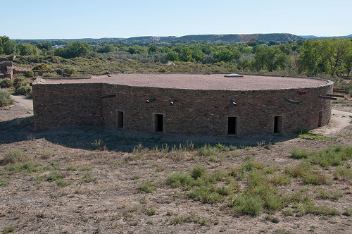
Construction of
the West Ruin, Aztec’s largest great house, started around 1100 CE, with
tree-ring dating (dendrochronology) confirming beams cut in 1111–1115
CE. Built in the Chacoan architectural style, it featured:
Core-and-veneer masonry: Thick sandstone walls with rubble cores and
finely shaped exterior stones.
Planned layout: A U-shaped,
three-story structure with 400–450 rooms, enclosing a central plaza.
Ceremonial features: A large kiva in the plaza and a possible great kiva
nearby, used for communal rituals.
Aztec’s East Ruin and smaller
sites, like North and South Mounds, followed, forming a cluster of great
houses and community structures. By 1125 CE, Aztec was a regional
center, housing 500–1,000 people in the great houses and surrounding
hamlets. Its role mirrored Chaco’s, facilitating trade in turquoise,
macaw feathers, and copper bells from Mesoamerica, and hosting
ceremonies tied to astronomical events, as suggested by wall alignments
to solstices.
Aztec’s prosperity coincided with Chaco’s decline
around 1130–1150 CE, possibly due to drought, social unrest, or resource
depletion. Some scholars propose Aztec became a successor capital, with
elites relocating north, evidenced by continued construction and
Chacoan-style artifacts like cylindrical jars and T-shaped doorways. The
West Ruin’s expansion, adding a northern wing by 1150 CE, supports this
theory, though others argue Aztec was a peer center, not a direct
replacement.
After 1150 CE, Aztec transitioned to a Mesa Verdean cultural phase,
reflecting influences from the San Juan Basin’s northern communities,
centered 40 miles north in Mesa Verde. Architectural changes included
smaller, less formal kivas and thicker walls, as seen in the East Ruin’s
additions. The population grew, with new room blocks and kivas built,
suggesting immigration or local consolidation. The Hubbard Tri-Wall
Structure, a unique three-walled kiva built around 1200 CE, indicates
ceremonial innovation, possibly linked to Katsina religion precursors.
Aztec remained a trade hub, with pottery from the Kayenta region
(Arizona) and obsidian from the Jemez Mountains. Agriculture thrived,
with irrigation ditches diverting Animas River water to fields,
supporting maize and amaranth. Hunting (deer, rabbits) and gathering
(piñon nuts) supplemented diets. The community’s social structure likely
included religious leaders and clan-based kinship, with great houses
serving elite families and ceremonial gatherings.
By 1275–1300
CE, Aztec was abandoned, mirroring a regional exodus from the Four
Corners. Prolonged droughts (1276–1299 CE), documented by tree-ring
data, reduced crop yields, while social tensions or external pressures
(e.g., Athabascan arrivals) may have contributed. Residents likely
migrated south to the Zuni and Hopi areas or east to the Rio Grande
pueblos, where descendants maintain cultural ties to Aztec.
Spanish explorers, beginning with Francisco Vázquez de Coronado’s 1540 expedition, passed near the Four Corners but left no record of Aztec. The 1776 Dominguez-Escalante Expedition, seeking a route from Santa Fe to Monterey, crossed the Animas River, noting abandoned ruins but not specifically Aztec. Navajo and Ute peoples, who moved into the region post-1300 CE, used the valley for hunting and trade, possibly referencing the ruins in oral traditions as “Anaasází” (Navajo for “ancient enemies” or “ancestors”).
American expansion followed the 1848 Treaty of Guadalupe Hidalgo,
which ceded New Mexico to the U.S. In the 1850s, settlers from Abiquiu
and Colorado established farms along the Animas, founding Aztec (the
modern town) in 1876. They misattributed the ruins to the Aztec Empire,
a common 19th-century error influenced by romanticized accounts of
Mesoamerican civilizations. Geologist John S. Newberry, visiting in
1859, described the ruins as “Aztec,” cementing the name despite no
Mesoamerican connection.
In the 1870s, settlers looted the ruins,
removing artifacts and using stones for buildings. Amateur excavations
by locals like Henry Van Buren damaged structures, prompting early
preservation calls. The 1889 discovery of a mummified child, dubbed
“Esther,” by settler John Koontz, drew regional attention, though the
body’s fate is unknown.
The late 19th century saw growing scientific interest in Ancestral
Puebloan sites. In 1892, Richard Wetherill, known for Mesa Verde’s Cliff
Palace, visited Aztec but focused elsewhere. The 1906 Antiquities Act,
protecting federal archaeological sites, set the stage for preservation.
In 1916, Earl H. Morris, a young archaeologist trained by Edgar L.
Hewett, began systematic excavations at Aztec’s West Ruin, funded by the
American Museum of Natural History (AMNH).
Morris, working from
1916–1921, excavated 178 rooms and the plaza kiva, uncovering 9,000
artifacts, including pottery, tools, and burials with turquoise jewelry.
His meticulous records, published in 1919, revealed Aztec’s Chacoan
origins and Mesa Verdean transitions. Morris restored parts of the West
Ruin, stabilizing walls, and in 1934 reconstructed the Great Kiva, a
40-foot-diameter ceremonial chamber, based on Chacoan models. While
later criticized for speculative elements (e.g., the roof design), the
reconstruction remains a visitor highlight.
On January 24, 1923, President Warren G. Harding proclaimed Aztec
Ruins a national monument, covering 27 acres, to protect its “scientific
and educational value.” Expansions in 1928 (West Ruin additions), 1930
(East Ruin), and 1988 (North and South Mounds) increased the area to 318
acres. The NPS assumed management in 1923, building a visitor center in
1930 (now the museum) and trails in the 1950s.
Further
excavations followed:
1930s–1940s: Morris and others explored the
East Ruin, revealing 200+ rooms and 28 kivas, though less preserved than
the West.
1960s–1980s: NPS archaeologists stabilized structures and
studied smaller sites, like the Hubbard Tri-Wall.
1990s–Present:
Non-invasive surveys, using ground-penetrating radar, mapped unexcavated
areas, preserving sites for future study.
In 1987, Aztec Ruins
joined Chaco Culture National Historical Park as a UNESCO World Heritage
Site, recognizing its role in the Chacoan system. The 2000s saw
repatriation efforts under NAGPRA (Native American Graves Protection and
Repatriation Act), returning artifacts and remains to affiliated tribes
like the Hopi, Zuni, and Navajo. The 2013 visitor center renovation
added interactive exhibits, and the NPS now collaborates with Puebloan
tribes to interpret the site, emphasizing living cultural connections.
Aztec Ruins encapsulates key themes:
Chacoan Influence: As a
northern outlier, it extended Chaco’s religious and trade networks, with
artifacts like macaw feathers linking it to Mesoamerica.
Mesa Verde
Transition: The shift to Mesa Verdean architecture reflects cultural
adaptation amid environmental stress.
Ancestral Puebloan Legacy: The
site’s masonry, kivas, and irrigation systems showcase engineering and
social complexity, influencing modern Puebloan communities.
Preservation Challenges: Early looting and the “Aztec” misnomer
highlight 19th-century cultural misunderstandings, while Morris’s work
pioneered scientific archaeology.
Indigenous Continuity: Consultation
with tribes ensures the site’s story respects living descendants,
countering historical erasure.
West Ruin: A self-guided, 0.5-mile trail (30–60 minutes) explores
400+ rooms, with intact T-shaped doorways and original wooden beams
(1111 CE). Accessible sections include Room 185, with 900-year-old
plaster.
Great Kiva: The 1934 reconstruction, 40 feet wide and 10
feet deep, is the largest of its kind, with interpretive signs
explaining rituals. Visitors can enter to envision ceremonies.
East
Ruin: Unexcavated but visible, with 200+ rooms and 28 kivas, viewable
from overlooks.
Hubbard Tri-Wall Structure: A rare, three-walled
kiva, partially excavated, suggesting unique ceremonial use.
Museum
and Visitor Center: Houses 3,000+ artifacts (pottery, sandals, jewelry),
a 15-minute film, and a replica kiva. Open daily 8 a.m.–5 p.m. (until 6
p.m. Memorial Day–Labor Day, closed major holidays).
Trails and
Events: The 0.75-mile Animas River Trail connects to riverside
cottonwoods. Ranger-led talks, summer solstice alignments, and Puebloan
cultural demonstrations enrich visits.
The monument is open
year-round, with spring (April–May) and fall (September–October) ideal
for mild weather (50–75°F). Summer highs reach 90°F, winter lows 20°F,
with occasional snow. Admission is $6/adult (2025), free for children
under 16, and America the Beautiful Passes ($80/year) apply.
Aztec Ruins lies 1 mile north of Aztec, New Mexico, at 725 Ruins
Road, near the Animas River’s west bank (elevation 5,600 feet). The
flat, fertile valley contrasts with the San Juan Basin’s arid mesas,
supporting cottonwoods, willows, and sagebrush. The site’s 318 acres
include the West and East Ruins, North and South Mounds, and unexcavated
hamlets, with the river shaping its agricultural past.
By Car:
From Farmington (14 miles west), take U.S. 550 south to NM-516 east.
From Durango, CO (35 miles north), take U.S. 550 south. From Albuquerque
(180 miles south), take I-25 north to U.S. 550. Parking is ample, with
ADA-accessible spaces.
Public Transit: None available. The nearest
airport is Farmington’s Four Corners Regional (15 miles), with car
rentals. Durango-La Plata County Airport (50 miles) offers more flights.
Facilities: The visitor center has restrooms, a bookstore, and picnic
areas. No lodging, food, or camping is on-site; Aztec (1 mile) offers
motels and dining (e.g., Roadside Restaurant). Farmington has more
options.
The NPS stabilizes masonry annually, addressing erosion from rain and freeze-thaw cycles. Climate change increases flood risks along the Animas, with a 2015 mine spill highlighting vulnerabilities. Visitation (50,000/year, up 20% since 2010) strains trails, prompting limits on group sizes (40 max). Vandalism is rare, but the NPS monitors petroglyphs and unexcavated sites. Tribal partnerships ensure culturally sensitive interpretation, with Hopi and Zuni advisors shaping exhibits. The 2022 Infrastructure Investment and Jobs Act funded trail upgrades and kiva stabilization, ensuring longevity.
Timing: Allow 1–2 hours for the West Ruin trail and museum. Spring
and fall offer ideal weather; summer requires hats and water; winter may
have icy paths. Check nps.gov/azru for ranger talk schedules.
Preparation: Bring water, sunscreen, and comfortable shoes. Cell service
is reliable, but download maps for nearby hikes. The trail is 80%
ADA-accessible; wheelchairs are available.
Safety: Stay on paths to
avoid unstable walls. Summer heat (90°F) risks dehydration; winter
(20°F) requires layers. Watch for snakes in summer.
Respect: Do not
touch artifacts, climb walls, or remove objects. Photography is allowed,
but drones require permits.
Nearby: Chaco Culture NHP (75 miles
south, 2 hours) complements a visit, as does Salmon Ruins (10 miles
west). Mesa Verde NP (80 miles north) offers cliff dwellings.
Farmington’s Bisti/De-Na-Zin Wilderness (40 miles) has surreal badlands.
Events: Summer solstice (June) and equinox (September) alignments draw
crowds. The Aztec Highland Games (October, nearby) add cultural flair.