Location: Arizona Map
Area: 83,840 acres (33,929 ha)
Info: (928) 674- 5500
Open: 8am- 5pm daily
Closed: Dec. 25
Official site
Canyon de Chelly National Monument is located in north-eastern Arizona on the border with the Navajo Nation. First natives that left evidence for their inhabitants were the ancient Pueblo People who were later followed by the Navajo tribes. Canyon de Chelly National Monument is a spectacular combination of natural beauty created by erosion and human activity who lived here in dwellings spread all along the canyon. Tourists should not forget that Canyon de Chelly is also a sacred place for Navajo Nation that venerate people who once lived here. Please respect their culture and traditions and don’t take souvenirs from any archaeological sites.
To this day Navajo tell a story about several incursions by the Europeans. First attacks were led by the Spanish empire which resulted in a massacre at the Massacre Cave. More recent incursion were led by the army of the United States. First military expedition inside territory of the future Canyon de Chelly National Monument were led by future New Mexico governor Leutenant Antonio Narbona in 1805. It was largely short lived. However, in 1863 Colonel Kit Carson sent his troops to permanently defeat the Navajo tribes. Many natives were massacred and survivors were forced to surrender. Remaining tribes were moved to Bosque Redondo, New Mexico.
Spider Rock (Canyon de Chelly National Monument)
Spider Rock is easily recognized and serves as an icon for Canyon de Chelly National Monument. Thousands of tourists come here and make pictures of this iconic geologic formation. However according to the Dine (Navajo tribe) tradition this rock formation should be avoided. Natives scarred their children telling them that a terrible creature that is known as Spider Woman lives on its top of a Spider Rock. Those kids that misbehave are snatched at night and dragged up a narrow mesa. Legend also claim white bones of little kids litter the top of the Spider Rock.
Massacre Cave (Canyon de Chelly National Monument)
Massacre Cave has its own tragic story behind its name. It was here where local Navajos tried to hide from the invading Spanish troops under leadership of Lieutenant Antonio Narbona in 1805. The Spanish fired into a cave killing dozens of people. According to Spanish account about 115 Navajos were killed including 90 warriors. Native tribes claim that most of the killed were in face civilians. Most of the warriors were hunting elsewhere and escaped the massacre. The Navajo name of the cave is "Two Fell Over" is a reference to one woman who grabbed a Spanish soldier and dragged him over a cliff. Both plunged to the depth of the canyon and died, thus giving the local name.
There are no fees to enter the park. To drive on the canyon bottom, a 4-wheel drive vehicle, a Park Service permit and an authorized Navajo guide are required. The fee is $15 an hour for 1 vehicle, $5 an hour for each additional vehicle with a 5-vehicle limit per guide. Hiking within the canyon requires a Park Service permit and an authorized Navajo guide, except along the 2.5-mile (4-km) White House Ruins Trail. One guide may take up to 15 people for $15 per hour.
Lodging
Holiday Inn Canyon de Chelly and Best
Western Canyon de Chelly Inn are nearby, between Chinle and Canyon
de Chelly.
Thunderbird Lodge, ☎ +1 928 674-5841, +1 928
674-5842. Open year-round. This comfortable motel-style facility is
at the canyon mouth.
Camping
A small campground with 15
basic units is at the monument itself; first-come, first-served,
open year-round.r.
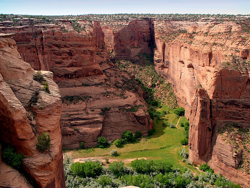
The Colorado Plateau formed about 60 million years ago when the
former basin first rose to later rise to today's plateau. As the land
rose, the rivers dug deeper and deeper into the rock. A second uplift,
the Defiance Uplift, occurred about 10 million years later. The Canyon
de Chelly was formed by rivers from the nearby Chuska Mountains, which
dug into the red sandstone of the Colorado Plateau during the slow
uplift over two million years, forming the bizarre canyon landscape.
At the exit, where the canyons meet, the cliffs are only a few
meters high, while inside the canyons they sometimes reach a height of
over 300 meters. The Chinle Wash, which flows through the canyon, only
carries water in the winter months, in summer the river bed is
superficially dry. The valley floor of the canyons is around 1600 meters
above sea level.
The Colorado Plateau formed about 60 million
years ago when the former basin first rose to later rise to today's
plateau. As the land rose, the rivers dug deeper and deeper into the
rock. A second uplift, the Defiance Uplift, occurred about 10 million
years later. The Canyon de Chelly was formed by rivers from the nearby
Chuska Mountains, which dug into the red sandstone of the Colorado
Plateau during the slow uplift over two million years, forming the
bizarre canyon landscape.
At the exit, where the canyons meet,
the cliffs are only a few meters high, while inside the canyons they
sometimes reach a height of over 300 meters. The Chinle Wash, which
flows through the canyon, only carries water in the winter months, in
summer the river bed is superficially dry. The valley floor of the
canyons is around 1600 meters above sea level.
The settlement history of the canyons can be divided into five
cultural sections.
2500 to 200 BC Chr.
Archaeological finds
show that as early as 2500 BC BC people lived in this place. It is the
oldest evidence of human settlement on the entire Colorado Plateau. From
this time there is still no evidence of settlements that indicate a
sedentary lifestyle. Apparently these were small nomadic groups who
temporarily used the canyon as a base for hunting and gathering
expeditions. Small camps under rock overhangs served as accommodation,
drawings on the walls of these are among the most important witnesses of
this first settlement.
200 BC to 750
200 BC The culture of the
basketmaker followed. They lived in small groups, were also hunters and
gatherers, but also had knowledge of agriculture. The first permanent
settlements are known from this period. Like their predecessors, they
used the rock overhangs as a dwelling and they also left drawings on the
surrounding walls.
750 to 1300
The Pueblo culture of the
Anasazi developed from the culture of the Basketmaker. From around 750
the first larger pueblos were built here at the foot of the rock walls.
It is still unclear what gave the impetus for this construction method.
Perhaps the space beneath the rock overhangs was no longer sufficient
for the growing number of people, or perhaps it was simply the proximity
to the fields.
1300 to 1700
At the beginning of the 14th
century, the Anasazi left Canyon de Chelly. Drought, overexploitation of
the fields and certainly conflicts with other peoples were probably the
causes. They continued south and west in search of areas offering better
living conditions.
In their place, other tribes, most notably the
Hopi, came to the area. It is known from the history of the Hopi that
they only used the land temporarily, for example for agriculture and as
a hunting ground in summer.
In the late 16th and early 17th
centuries, the Navajo, who call themselves Diné for "people" in their
own language, arrived on the Colorado Plateau from the north. Like their
predecessors, they used the bottom of the canyons and the lands of the
plateaus. Farming, fruit growing and animal husbandry were the basis of
their life. Small settlements of hogans, the traditional homes of the
Navajo, emerged.
1700 to 1868
Around 1700, Navajo members used
the canyon as a base for raids against pueblos further east. The main
goal of their raids, however, was to free their tribesmen, who were now
treated as slaves. At the end of the 17th century there were armed
conflicts between the Navajo, other tribes and the Spanish settlers from
the Rio Grande. As a result, the canyon, with its winding course and
rock caves, offered protection like a fortress. The Navajo built stone
walls along the trails and stockpiled food in hiding places.
Nevertheless, the Spanish, Ute and US troops entered the canyon and left
a scene of devastation in their wake. In a day-long battle, 115 Navajo
were killed. The scene of this fight has since been called "Massacre
Cave".
In 1863, Colonel Kit Carson launched a campaign against
the Navajo. Carson and his squad moved into the canyon from the east,
herding residents toward the west exit. Many were killed or captured. A
little later, Carson's force returned and destroyed everything that
remained after the first attack. The prisoners were taken 300 miles to
Fort Sumner, New Mexico, in a march now called "The Long Walk" (only
4,000 of the original 9,000 prisoners survived the march). In 1868 a
treaty was signed between the Navajo and the whites and after almost 5
years on the reservation they were finally able to return home.
Navajo families still live in the canyons today, farming and raising
sheep.
trivia
Canyon de Chelly served as the setting for the
1969 western Mackenna's Gold, starring Gregory Peck and Omar Sharif.