Location: Southeastern Utah Map
Area: 337,598 acres (136,621 ha)
Info: (435) 710 2313
Area: 337,598 acres
When to go: spring- fall
Activities: hiking, biking, boating
To see:
- Grand View Point
- rafting Cataract Canyon
- biking White Rim Road
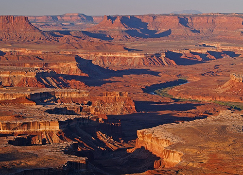
Canyonlands National Park lies in Southeastern Utah in United States. Canyonlands National Park covers an area of 337,598 acres (136,621 ha). Although it looks more like a landscape of Mars, this nature reserve boasts a great diversity in life that is concentrated in small patches around sources of water. Canyonlands National Park is located near a town of Moab in Southeastern Utah. Its landscape is shaped by two large canyons and its various branches that date back about 300 million years. The most beautiful views of the Canyonlands open in the areas of Grand View Point Overlook and Dead Horse Point. Famous author Edward Abbey who frequently visited these alien landscapes described Canyonlands National Park: "[Canyonlands is] the most weird, wonderful, magical place on earth- there is nothing else like it anywhere".
Canyonlands National Park was designated as a natural protected reserve by President Lyndon Johnson on September 12, 1964. It covers a total area of about 528 square miles or 1,366 square kolometers.
Entrance fees are $5 for individuals on foot, bike
or motorcycle, and $10 for private vehicles (fees are good for seven
days). A Local Passport may be purchased for $25 and allows
unlimited entry to Canyonlands National Park, Arches National Park,
Hovenweep National Monument and Natural Bridges National Monument
for one year.
There are several passes for groups traveling
together in a private vehicle or individuals on foot or on bike.
These passes provide free entry at national parks and national
wildlife refuges, and also cover standard amenity fees at national
forests and grasslands, and at lands managed by the Bureau of Land
Management and Bureau of Reclamation. These passes are valid at all
national parks including Canyonlands National Park:
The $80
Annual Pass (valid for twelve months from date of issue) can be
purchased by anyone. Military personnel can obtain a free annual
pass in person at a federal recreation site by showing a Common
Access Card (CAC) or Military ID.
U.S. citizens or permanent
residents age 62 or over can obtain a Senior Pass (valid for the
life of the holder) in person at a federal recreation site for $80,
or through the mail for $90; applicants must provide documentation
of citizenship and age. This pass also provides a fifty percent
discount on some park amenities. Seniors can also obtain a $20
annual pass.
U.S. citizens or permanent residents with permanent
disabilities can obtain an Access Pass (valid for the life of the
holder) in person at a federal recreation site at no charge, or
through the mail for $10; applicants must provide documentation of
citizenship and permanent disability. This pass also provides a
fifty percent discount on some park amenities.
Individuals who
have volunteered 250 or more hours with federal agencies that
participate in the Interagency Pass Program can receive a free
Volunteer Pass.
4th graders can receive an Annual 4th Grade Pass
that allows free entry for the duration of the 4th grade school year
(September-August) to the bearer and any accompanying passengers in
a private non-commercial vehicle. Registration at the Every Kid in a
Park website is required.
In 2018 the National Park Service will
offer four days on which entry is free for all national parks:
January 15 (Martin Luther King Jr. Day), April 21 (1st Day of NPS
Week), September 22 (National Public Lands Day), and November 11
(Veterans Day weekend).
Fees may be waived for groups whose
purpose is educational rather than recreational; check with the park
in advance for fee waiver details.
The Island in the Sky and Needles areas are accessible via US 191,
which runs through Moab. The Maze is the most remote of the three
regions and is only accessible from the west via State Roads 24 or 95
and then dirt roads.
There are no road connections between the
individual sub-areas within the park.
Island in the Sky
The
Island in the Sky is a sprawling plateau (mesa) enclosed by the Colorado
and Green Rivers. There are many spectacular views of the White Rim, a
sandstone cliff some 360 meters below the plateau, and of the river
courses a further 300 meters below the White Rim. Running along the
White Rim is the popular 100-mile White Rim Trail, a dirt rock trail
open to 4WD or mountain bike use with park authority approval. The
journey by car takes two to three days, and when the permit is issued,
overnight accommodation is allocated, the only equipment being a single
toilet building. The number of passes issued per day is strictly
limited, so that the visitor is usually completely alone on the
sometimes adventurous route.
The Colorado River's Big Drop Rapids
are located 1128 meters above sea level.
The Needles
The
Needles takes its name from the red and white veined rock spikes that
dot the area. In addition, there are a number of other rock formations
such as canyons, sinkholes, crevices and stone arches. Unlike Arches
National Park, where many of these arches are accessible by short walks
or even by car, in the Needles District they are inland and only
accessible by 4x4 or long hikes.
The area was formerly home to
the Pueblo Indians, many remains of which remain. Many of the tools and
odds and ends have been stolen by antiquities hunters, but many of the
stone houses and earthen huts are well preserved. The members of the
Pueblo culture have also left traces in the form of petroglyphs. The
most famous can be seen on the so-called Newspaper Rock near the Visitor
Center at the entrance. In the southeast, the Needles District of the
national park borders directly on the Bears Ears National Monument.
Cathedral Point in the Needles District is the highest point in the
park at 2170 meters.
the maze
Located west of the Colorado and
Green Rivers, the Maze District is the most remote and inaccessible
subdivision.
The first Native Americans to visit the region lived around 10,000
years ago. These were nomadic groups of hunter-gatherers. Their survival
depended on their ability to find wild plants and animals. The absence
of permanent structures tends to prove that these groups never really
settled in the region. Nevertheless, they left traces of their
craftsmanship and art. Thus, several petroglyphs have been found on the
rock walls of Horseshoe Canyon, notably at what is today the Horseshoe
Canyon Archeological District.
At the beginning of the Christian
era, it seems that several Native American groups began to practice
agriculture as well as small livestock breeding, forcing them to become
sedentary. They belong to the Fremont people and the Anasazis. They grew
corn, beans and squash; they raised turkeys and dogs. They built
villages of stone and adobe, comparable to those of Mesa Verde. Several
groups migrated from Mesa Verde to settle in Salt Creek around the 13th
century. Several troglodyte habitat sites are still visible today
(Roadside Ruin, Aztec Butte, etc.; see also the Salt Creek Archeological
District). From the 14th century, it seems that these Amerindian peoples
migrated south, perhaps because of a deterioration in climatic
conditions. The Pueblos, Acomas, Zuñis, and Hopi Mesas are their modern
descendants.
Before the disappearance of the Anasazi, other
Indian peoples appeared in the region: the Utes and the Paiutes arrived
around the 9th century. It was not until the 14th century that the
Navajos settled from the north. These three peoples still live in the
Canyonlands today.
In 2003, it was in Blue John Canyon that Aron
Ralston's accident took place, after which he had to cut off his arm to
survive. He wrote his story himself, which is told in Danny Boyle's film
127 Hours (2011).
On the high plateaus of the park and in the ravines, drought shrivels the trees but in the sand vegetation survives: ephedras, yuccas, grasses whose existence is due to the presence of cyanobacteria which amalgamate the sand and thus allow the plants to grow. take root in stable soil.
Although the Canyonlands have a mineral and desert appearance, life is omnipresent in the park. Animals that are easily observed are birds (eagles, etc.), lizards and rodents (squirrels, chipmunks) which come out during the day. Like the flora, the fauna has adapted to difficult and changing climatic conditions. Many animals only come out at night to take advantage of more moderate temperatures in summer: this is the case of the neotoma, the kangaroo rat, the scone, the lynx, the fox, the puma, the bats and the owls. Others come out at dusk or dawn: coyotes, porcupines, birds, rabbits, hares and deer. Snakes live in a state of torpor during winter and are nocturnal in summer.
The 2012 novel Land der rote Steine by Austrian writer Walter Kappacher is largely set in the Maze District.