Location: Klamath County, OR Map
Area: 20.6 sq mi (53 km2)
Max Depth: 1,949 ft (594 m)
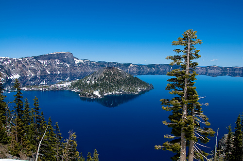
Crater Lake National Park, situated in southern Oregon within the United States, serves as a stunning protected area renowned for its namesake feature: Crater Lake itself. This remarkable body of water holds the title of the deepest lake in the country, plunging to an impressive 1,949 feet (594 meters), and is celebrated worldwide for its strikingly vivid deep blue hue, which results from its exceptional clarity and purity. The lake's water is sourced exclusively from rainfall and snowmelt, with no rivers or streams flowing in or out, making it one of the clearest and most pristine lakes on Earth—visibility can extend up to 140 feet (43 meters) below the surface on clear days.
The origins of Crater Lake trace back to a cataclysmic volcanic event
involving Mount Mazama, an ancient volcano in southern Oregon that once
towered around 11,000 feet (3,353 meters) high. Approximately 7,700
years ago (around 5700 BC), a sequence of massive eruptions culminated
in the mountain's summit collapsing inward into its emptied magma
chamber, forming a vast caldera roughly 6 miles (9.7 kilometers) across.
Over centuries, accumulated precipitation from snow and rain gradually
filled this depression, creating the lake we see today. In terms of
maximum depth, Crater Lake ranks as the deepest in the United States,
second deepest in North America (behind Great Slave Lake in Canada), and
ninth deepest globally. When measured by average depth—1,148 feet (350
meters)—it stands as the deepest in the Western Hemisphere and third
deepest worldwide. Native American tribes, such as the Klamath people,
witnessed this explosive formation and incorporated it into their oral
histories and spiritual beliefs, viewing the site as sacred.
The
first documented European American to encounter the lake was gold
prospector John Wesley Hillman in 1853, who stumbled upon it during a
mining expedition and was awestruck by its beauty. Preservation efforts
gained momentum in the late 19th century, largely driven by
conservationist William Gladstone Steel, who dedicated decades to
advocating for its protection after visiting in 1885. His tireless
campaigns, including petitions and publicity, led to President Theodore
Roosevelt signing legislation that established Crater Lake as the fifth
national park in the U.S. on May 22, 1902.
Perched at elevations exceeding 7,000 feet (2,150 meters) in the Cascade Range, Crater Lake experiences a harsh, alpine climate where snowfall can persist throughout much of the year, sometimes blanketing the landscape even in summer. The park receives an astonishing average of 533 inches (1,353 centimeters) of snow annually, leading to frequent road and trail closures during fall, winter, and spring due to heavy accumulation and hazardous conditions. Weather can shift rapidly, with clouds often obscuring views of the lake, so visitors are advised to check webcams and forecasts in advance. Summers bring milder temperatures and clearer skies, making July through September the optimal period for exploration when all amenities, including the scenic Rim Drive (a 33-mile loop offering panoramic vistas), are fully accessible. However, even in peak season, be prepared for potential wildfire smoke affecting air quality, as the region is prone to seasonal blazes—monitoring the Air Quality Index (AQI) is recommended.
For planning your trip, the park offers several resources to enhance
safety and enjoyment. Entrance fees apply year-round (typically $30 per
vehicle for a 7-day pass as of recent updates, though check the official
NPS site for current rates and fee-free days), and the free NPS app
provides offline maps and guides.
Steel Visitor Center (named after
William Gladstone Steel), ☏ +1 541-594-3100. Open from April through
early November from 9 AM to 5 PM, and from early November to April from
10 AM to 4 PM (closed on Christmas Day). Staffed by knowledgeable park
rangers, this center provides essential services such as trip planning
assistance, current weather updates, backcountry camping permits,
cross-country ski route advice, and general safety guidance. Visitors
can also enjoy a complimentary 18-minute interpretive film, Crater Lake:
The Mirror of Heaven, screened every half hour in the on-site
auditorium, which delves into the park's geology, history, and ecology.
Rim Village Visitor Center, located along the southern edge of the
caldera about 200 yards west of the historic Crater Lake Lodge, ☏ +1
541-594-3000. Operates from late May to September, 9:30 AM to 5 PM.
Here, you can obtain general park brochures, secure backcountry permits,
and browse educational exhibits and souvenirs for purchase. Both centers
are free to enter and serve as gateways to deeper exploration.
Beyond
these, the park boasts a variety of activities to suit different
interests, including hiking on trails like the challenging Cleetwood
Cove Trail (the only path down to the lakeshore for boat tours),
ranger-led trolley tours around the rim, and seasonal boat excursions on
the lake itself (advance reservations recommended). Wildlife enthusiasts
might spot black bears, elk, bald eagles, or rare plants adapted to the
volcanic soil, while stargazing is exceptional due to minimal light
pollution. For overnight stays, options include the Crater Lake Lodge
(open summers only) or nearby campgrounds, with pets allowed in limited
areas but prohibited on trails for safety reasons. Always prioritize
"Leave No Trace" principles to preserve this natural wonder.
By Plane
The primary airport serving Crater Lake National Park is
the Rogue Valley International-Medford Airport (MFR IATA), situated
about three miles (4.8 km) north of Medford, Oregon, and approximately
75 miles (120 km) southwest of the park's headquarters. This airport
offers commercial flights from major hubs like San Francisco, Seattle,
Portland, and Denver, making it a convenient option for travelers. From
there, you can rent a car for the roughly 90-minute drive to the park
via Highway 62. Alternative airports include Crater Lake-Klamath
Regional Airport (LMT) in Klamath Falls, about 60 miles (97 km)
southeast of the park, which handles limited commercial and general
aviation flights and requires a drive of around 75 minutes to the south
entrance. For those flying into larger cities, Eugene Airport (EUG) is
120 miles (193 km) north, with a drive time of about 2.5 hours, while
Redmond Municipal Airport (RDM) near Bend is roughly 100 miles (161 km)
northeast, taking around 2 hours. Portland International Airport (PDX),
250 miles (402 km) north, is a major hub but involves a longer 5-hour
drive to the north entrance. Note that there is no direct public
transportation from any airport to the park, so renting a vehicle or
arranging a shuttle/tour is essential.
By Car
Crater Lake
National Park is accessible year-round via its west and south entrances,
but the north entrance typically closes from mid-October to mid-June due
to heavy snowfall, so plan accordingly and check road conditions in
advance. The park's roads are generally well-maintained, though winter
driving can be hazardous with potential for ice and closures.
From the North
If traveling from Eugene, Portland, or other northern
points along Interstate 5, head south on I-5 to Exit 124 in Roseburg,
then proceed east on Oregon Highway 138 for about 92 miles (148 km) to
reach the north entrance—a journey that usually takes around 2 hours
from Roseburg.
From Bend or central Oregon, drive south on U.S.
Highway 97, then west on Oregon Highway 138 to the north entrance,
covering roughly 100 miles (161 km) from Bend in about 2 hours.
From the South
Coming from Medford or southern points on Interstate
5, take I-5 north to Exit 30 in Medford, then follow Oregon Highway 62
north and east for approximately 75 miles (121 km) to the west entrance,
which is open all year and takes about 1.5 hours.
From Klamath Falls,
head north on U.S. Highway 97 to Oregon Highway 62, then continue north
and west to the south entrance, also open year-round, spanning about 60
miles (97 km) and around 1 hour of driving.
On Foot
The iconic
Pacific Crest Trail (PCT), a renowned long-distance hiking path
stretching from the U.S.-Mexico border to the U.S.-Canada border along
the West Coast through California, Oregon, and Washington, traverses
Crater Lake National Park. Within the park, the trail covers 33 miles
(53 km), providing thru-hikers with stunning panoramic views of the
surrounding mountains and the deep blue lake itself. A highlight is the
6-mile (9.7 km) section along the caldera's west rim, offering dramatic
overlooks. Many hikers opt for the alternate Rim Trail route for even
more scenic lake vistas, though the official PCT route is well-marked
and challenging, with elevations ranging from 5,000 to 7,600 feet (1,524
to 2,316 m). Permits are required for overnight stays, and resupply
points are limited, so preparation is key.
Park entrance fees grant access for a full seven days from the date
of purchase. As of late 2025, the fees vary by season and mode of entry,
with youth aged 15 and under admitted free in most cases. No
reservations are required for entry, but payment must be made via
debit/credit cards or digital wallets since cash is not accepted.
Current rates include:
Bicycle or On Foot: $15 per person (covers
one individual without a motor vehicle).
Motorcycle: $25 from May 22
to October 31 (admits one or two passengers); reduced to $15 from
November 1 to May 21.
Private Vehicle: $30 from May 22 to October 31
(covers the vehicle and all its occupants); drops to $20 from November 1
to May 21.
Crater Lake Annual Pass: $55 (provides unlimited entry for
one year to Crater Lake National Park, plus Lava Beds National Monument,
Lassen Volcanic National Park, and Whiskeytown National Recreation Area;
admits the pass holder and passengers in a private non-commercial
vehicle, or the holder plus up to three others on foot or bike).
The America the Beautiful Pass series (also known as the Interagency
Pass) offers broader access, covering entry to Crater Lake and over
2,000 federal recreation sites, including all national parks, many
national monuments, wildlife refuges, forests, and lands managed by
agencies like the U.S. Forest Service, Bureau of Land Management, and
others. One pass typically covers an entire group in a private vehicle
or up to four individuals entering on foot or by bike. Passes are
non-refundable, non-transferable, and require a valid photo ID when
used. They also cover standard amenity fees (like day-use areas) at
participating sites. Available options include:
Annual Pass: Open
to anyone for $80; valid for 12 months from issuance. A discounted $20
version is available for U.S. citizens or permanent residents aged 62 or
older (Senior Annual Pass).
Lifetime Senior Pass: For U.S. citizens
or permanent residents 62 and up, priced at $80 for lifelong access;
includes a 50% discount on certain park amenities like camping or tours.
Military Passes: Free Annual Pass for current U.S. military members and
their dependents (requires a Common Access Card or Military ID). A free
Lifetime Pass is available for veterans and Gold Star Families
(relatives of service members killed in action), with documentation
required.
Access Pass: Free lifetime pass for U.S. citizens or
permanent residents with permanent disabilities; proof of eligibility
needed, and it offers a 50% discount on select amenities.
Volunteer
Pass: Free for those who have logged 250 or more volunteer hours with
participating federal agencies.
4th Grade Pass: Free for U.S. fourth
graders and their families (valid from September through August of the
school year); requires registration via the Every Kid Outdoors website
and covers entry for the bearer plus passengers in a private vehicle.
Additionally, educational groups may qualify for academic fee
waivers if visiting for scientific or learning purposes, with advance
application required.
The National Park Service designates several
fee-free days each year, when entrance fees are waived at all sites that
normally charge them (though other fees, like for camping or tours, may
still apply). Starting in 2026, these free days will be limited to U.S.
citizens and residents, with nonresidents paying standard rates. For
2026, the scheduled fee-free dates are:
February 16: Presidents Day
(Washington's Birthday)
May 25: Memorial Day
June 14: Flag
Day/President Trump's birthday
July 3–5: Independence Day weekend
August 25: National Park Service Birthday (110th anniversary)
September 17: Constitution Day
October 27: Theodore Roosevelt's
birthday
November 11: Veterans Day
The Scenic Rim Drive is a historic 33-mile (53 km) loop road that
fully encircles Crater Lake in Oregon's Crater Lake National Park,
providing a range of stunning vantage points over the vibrant blue lake,
the steep caldera rim, and the diverse surrounding landscapes of dense
forests, wildflower meadows, and volcanic features. Typically open only
in the summer months from late June through late October (weather and
snow conditions permitting, with full closure starting November 1 due to
heavy annual snowfall averaging 41 feet), the drive includes around 30
carefully designed overlooks equipped with parking areas and
interpretive signs that explain the area's geology, ecology, and
cultural history. Designed in the 1930s to harmonize with the natural
environment, the narrow, winding road has a 35 mph speed limit,
bidirectional traffic, and is shared with cyclists—visitors should drive
cautiously, especially in RVs or while towing, and consider guided
trolley tours from Rim Village for a narrated experience.
Access to
the lake's shoreline is limited to a single steep path: the Cleetwood
Cove Trail on the north side, a challenging 2.2-mile round-trip hike
with about 700 feet of elevation change that descends switchbacks to the
water's edge, where seasonal boat tours depart to cruise the lake, visit
Wizard Island (a volcanic cinder cone rising 760 feet above the water),
and learn about the caldera's formation from a massive eruption 7,700
years ago. Swimming, fishing, and wading are allowed here, but the trail
is usually open only from mid-June to late October. Scattered along the
Rim Drive are five designated picnic areas, offering spots to relax amid
the scenery, plus trailheads for various hikes of differing
difficulties. For instance, from Rim Village on the south side, hikers
can embark on the Garfield Peak Trail, a strenuous 3.4-mile round-trip
route gaining over 1,000 feet in elevation through shaded forests and
open meadows, culminating in sweeping 360-degree panoramas of the lake,
distant peaks like Union Peak, and the Klamath Basin.
The drive
connects to key sites around the caldera: Lightning Springs trailhead on
the west side (leading to a moderate 8.4-mile round-trip hike to a
spring and creek along the Pacific Crest Trail), Cleetwood Cove on the
north, Mount Scott on the east (the park's highest point at 8,929 feet,
accessible via a moderate 4.4-mile round-trip trail with 1,250 feet of
gain for unobstructed views across the lake and Cascade Range), and Sun
Notch Viewpoint plus Crater Peak on the south (the latter a
moderate-to-strenuous 6.5-mile round-trip hike through forests and
grasslands to a summit blanketed in wildflowers during summer). Among
the highlights are Kerr Notch and Sun Notch viewpoints, which deliver
some of the most breathtaking sights—Sun Notch, in particular, overlooks
the dramatic Phantom Ship (an ancient, erosion-resistant andesite rock
formation resembling a ghostly sailing vessel, dating back 400,000 years
and standing 170 feet tall) and gazes across the lake to Wizard Island.
Other notable overlooks include Cloudcap Overlook (the highest drive-up
viewpoint at nearly 8,000 feet, with expansive vistas), Pumice Castle
(showcasing orange pumice layers in the cliffs), and Phantom Ship
Overlook for closer perspectives on the striking formation.
Beyond
the drive, the park boasts numerous trails suitable for equestrians,
including sections of the iconic Pacific Crest Trail (PCT), which spans
about 33 miles through the park's backcountry with patchy snow lingering
into June and opportunities for multi-day treks amid old-growth forests
and pumice flats—horses are permitted on the PCT but prohibited on paths
directly to the lake shore or in sensitive areas like around Little
Crater. If horseback riding isn't your style, exploring on foot is
equally rewarding, with over 90 miles of trails revealing volcanic
pinnacles, cascading waterfalls like Plaikni Falls, and vibrant
wildflower displays in season. Keep watchful for wildlife, including
mule deer grazing in grassy hills and meadows, as well as pikas,
yellow-bellied marmots, songbirds, and woodpeckers in fire-scarred
zones—always practice Leave No Trace principles to preserve the pristine
environment.
The Pinnacles
Located at the end of Pinnacles Road in Crater Lake
National Park, this striking geological feature is accessible during the
summer months via a paved, 6-mile (9.6 km) spur road branching off from
the main Rim Drive. These haunting, needle-like spires—formed from
eroded volcanic ash and known as fossil fumaroles—tower dramatically
along the banks of Sand and Wheeler Creeks, remnants of the massive
eruption of Mount Mazama around 7,700 years ago that created the
caldera. The formations rise from layers of pumice and scoria, creating
an otherworldly landscape that's best explored on the short Pinnacles
Valley Trail, an easy 0.8-mile out-and-back hike that takes about 16-36
minutes and offers close-up views of the spires. Along the drive, you'll
pass the quaint Lost Creek Campground, a small site with 16 tent-only
spots nestled in the forest. Historically, the road extended eastward
beyond the current turnout to the park's former East Entrance; today,
that section has been converted into a scenic path that traces the rim
of Sand Creek, providing additional vantage points of the pinnacles
before reaching the preserved entrance arch. For an alternative return
route to Rim Drive, opt for the Grayback Road, a one-way, westbound
gravel path that adds a rugged twist to the journey.
Sinnott
Memorial Overlook
Perched dramatically on the caldera cliff about 900
feet above Crater Lake, the Sinnott Memorial Overlook is a historic
viewpoint typically open from late June through mid-October, weather
permitting. Built in 1930 as part of the Works Progress Administration
(WPA) era, this sheltered observation station functions as a modest
natural history museum with engaging exhibits on the park's geology,
volcanic history, and ongoing lake research, including a relief model of
the area and displays about the ecosystem. It offers one of the most
iconic panoramic views of the deep blue lake, encompassing landmarks
like Wizard Island, Llao Rock, and even distant Mount Thielsen on clear
days—all at no additional cost beyond park entry fees. Situated just
below the Rim Village Visitor Center, it's an essential stop for
understanding the science behind Crater Lake's formation and beauty.
Watchman Observation Station
The Watchman Observation Station,
also known as Watchman Lookout Station No. 168, sits atop Watchman Peak
in Crater Lake National Park and serves as a historic fire lookout tower
constructed between 1931 and 1933. Reaching it involves a moderately
strenuous 1.6-mile round-trip hike from the Watchman Trailhead, with
about 420 feet of elevation gain over switchbacks, taking around 45
minutes to complete and rewarding visitors with unparalleled 360-degree
vistas of the lake, Wizard Island, and the surrounding Cascade Range.
Originally part of the park's fire detection network, the two-story
stone structure now provides an educational glimpse into wildfire
monitoring history while offering the best overlook for appreciating the
caldera's scale and the volcanic landscape beyond. Though the interior
is often closed to the public, the exterior platform alone makes the
trek worthwhile for its sweeping panoramas.
Boat Tours
Experience the stunning beauty of Crater Lake up close
with guided boat excursions, ideal for adventurers prepared for a
moderate hike. The only access to the lake's shore is via the
challenging Cleetwood Cove Trail, a 2.2-mile (3.5 km) round-trip path
that descends about 700 feet (213 m) in elevation—equivalent to climbing
70 flights of stairs. The descent typically takes 30-45 minutes, while
the return ascent can take 45 minutes to an hour, depending on fitness
level. This steep, dusty trail requires sturdy hiking shoes and is not
suitable for those with heart, respiratory, or mobility issues. Once at
the dock, tours are operated by Explor Crater Lake, a park concessioner,
with U.S. Coast Guard-certified boats and captains. Most cruises include
narration from a park ranger highlighting the lake's geology, history,
and ecology.
Options include a standard 2-hour lake cruise that
circumnavigates the caldera's perimeter, offering views of iconic
features like the Phantom Ship rock formation and the rugged cliffs. For
a more immersive adventure, opt for tours that include a drop-off at
Wizard Island, a 763-foot (232 m) cinder cone volcano rising from the
lake. An additional fee allows 3 hours on the island to hike the
0.9-mile (1.4 km) trail to the summit crater (known as the Witch's
Cauldron, with panoramic views), swim in the clear waters of Fumarole
Bay, or simply explore the forested terrain. A shuttle service is also
available for direct transport to the island, with departures around
9:00 AM and 11:30 AM during peak season.
Tours run daily from late
June to mid-September (weather permitting), when the trail is snow-free,
but are subject to cancellation due to wind, rough waters, smoke, or
safety concerns—refunds or rescheduling are provided in such cases. In
2025, the season has concluded early due to trail and marina
rehabilitation, with full closures planned for 2026 and 2027. Prices
start around $25 for basic cruises (though current rates may be higher;
contact Explor Crater Lake at 866-292-6720 for exact 2025-2026 details),
and advance reservations are recommended as only half the seats are
bookable online. Children must be at least 3 years old; life vests are
required for those 12 and under. Bring sunscreen, water, snacks, layers
for variable weather (sun, wind, or chill), and note there are no
restrooms on the boats—composting toilets are available at the dock.
While costly, the unparalleled perspectives of the deepest lake in the
U.S. (1,943 feet/592 m) make it a worthwhile splurge for nature
enthusiasts.
Fishing
Anglers can enjoy fishing in Crater Lake
and its surrounding streams from a half-hour before sunrise to a
half-hour after sunset, providing ample daylight opportunities. The
primary season aligns with trail access from late June to October, but
year-round fishing is legally allowed in the lake whenever reachable
(though winter access is extremely limited due to snow). No state
fishing license is needed within park boundaries, making it accessible
for visitors. To preserve the lake's pristine ecosystem—no native fish
originally existed here, with stockings occurring between 1888 and
1941—strict rules apply: only non-organic artificial lures or flies are
permitted; all organic bait (live or dead, including worms, fish eggs,
power bait, or roe) is banned to prevent introducing non-native species.
The lake hosts thriving populations of kokanee salmon (landlocked
sockeye, estimated at 60,000) and rainbow trout, with no size or catch
limits. Streams feature brook trout, brown trout, rainbow trout, and
protected native bull trout (a threatened species under the Endangered
Species Act—must be released unharmed if caught). Sun Creek and Lost
Creek are closed to fishing to safeguard bull trout habitats, while
Annie Creek is accessible via the south entrance Sno-Park. Most streams
are hard to reach due to steep canyons, often requiring entry from
adjacent U.S. Forest Service lands (check maps and conditions at nearby
ranger stations). Private boats, flotation devices, waders, or wetsuits
are prohibited in the lake to minimize contamination risks. Fishing from
shore is limited to the 0.25-mile rocky stretch at Cleetwood Cove or
Wizard Island docks (except when boats are present; no fishing within
200 feet of Cleetwood docks or from motor road bridges). Caught fish
must be packed out whole—cleaning or gutting at the lake or streams is
not allowed to avoid attracting wildlife or polluting waters. For a
unique twist, combine fishing with a Wizard Island boat tour drop-off.
Scuba Diving
While historically allowed, scuba diving in Crater
Lake is currently prohibited under the park's Superintendent's
Compendium to protect what may be the purest water on Earth from
potential contamination by gear or divers. This ban, initially temporary
in 2015 due to invasive species threats, appears ongoing as of recent
updates (last confirmed in 2022 compendium). Snorkeling, wetsuits, fins,
masks, and similar equipment are also not permitted. For those
interested in underwater exploration, note that past scientific dives
using submersibles have revealed fascinating features like bacterial
mats, moss-covered trees at depths up to 100 feet (30 m), and
hydrothermal vents, but public access is restricted. If planning a
visit, confirm current regulations at the park headquarters.
In the
past, free permits were issued at the Canfield Building (Ranger Station)
in park headquarters after verifying diving certification and providing
lake-specific briefings. The lake's high elevation (6,173 feet/1,881 m)
required using high-altitude dive tables for safe decompression
planning. Access mirrored boat tours via the 1.1-mile (1.8 km) Cleetwood
Trail descent of 700 feet (213 m), demanding divers carry all gear (no
wheeled carts allowed). Restrooms were available at trail ends, but no
food or water facilities existed lakeside. Conditions were extreme: cold
water temperatures (around 38-55°F/3-13°C), low visibility in spots, and
physical exertion from the hike.
Day Hiking
Explore the park's
diverse landscapes through over 90 miles (145 km) of trails, ranging
from easy 15-minute strolls to strenuous multi-hour treks, showcasing
wildflowers, old-growth forests, volcanic features, and wildlife like
pikas, marmots, and birds. Popular options include the short 0.5-mile
(0.8 km) Castle Crest Wildflower Garden loop (bursting with blooms in
summer), the 1.1-mile (1.8 km) Godfrey Glen loop through ancient
hemlocks, or the moderate 2-mile (3.2 km) Plaikni Falls trail to a
scenic waterfall—partially accessible for all-terrain wheelchairs. For
longer adventures, try the 6.5-mile (10.5 km) Crater Peak hike with
summit views or sections of the 33-mile (53 km) Pacific Crest Trail
traversing the park. Trails often feature elevation gains (e.g., 1,600
feet/488 m on Union Peak's 9.8-mile/15.8 km round trip) and may have
patchy snow into July.
Hiking or climbing inside the caldera walls is
strictly prohibited due to extreme dangers like unstable slopes,
rockfall, and no rescue access—violations can result in fines. The
Cleetwood Cove Trail provides the sole legal path to the lake shore.
Pets are allowed on some trails (e.g., Grayback Road, Pacific Crest) but
banned on others (e.g., Annie Creek). Safety tips: Carry water, snacks,
and layers for variable weather; expect high altitudes (up to 8,929
feet/2,721 m at Mount Scott) that can cause fatigue or altitude
sickness. Check for seasonal closures, bear activity, or fire
damage—many areas feature post-wildfire regeneration with vibrant
wildflowers and pollinators. Self-guiding brochures are available at
select trailheads for educational hikes.
Bicycling
Cycling at
Crater Lake is best from July to September when roads are snow-free and
weather is milder, avoiding early-season hazards like lingering ice or
construction. Stick to paved routes only, including the iconic 33-mile
(53 km) Rim Drive loop around the caldera, offering breathtaking
overlooks but demanding due to steep hills (total elevation gain of
about 3,650 feet/1,113 m), high altitudes (up to 7,700 feet/2,347 m at
Cloudcap), narrow shoulders, blind curves, and vehicle traffic. Other
options include the North Entrance Road or shorter segments like the
4.6-mile (7.4 km) stretch from North Junction to Cleetwood Cove.
This
activity suits experienced riders comfortable sharing roads with
cars—novices may find it challenging or risky. Safety essentials: Wear
helmets, use bright clothing for visibility, carry repair kits, and ride
single-file. Watch for wildlife crossings, falling rocks, and sudden
weather changes. As of 2025, the North Entrance Road and Rim Drive close
seasonally (typically November to June/July), with reopenings around
mid-2026; check alerts for updates. Fat tire biking is prohibited on
winter trails. For a full loop from park headquarters, expect cumulative
climbs like 650 feet (198 m) to Rim Village.
Skiing or
Snowshoeing
During winter, when the park receives an average of 42
feet (13 m) of snow, cross-country skiing and snowshoeing offer serene
ways to traverse ungroomed trails—permits are required for backcountry
use but free for day activities. The vehicle-closed Rim Drive transforms
into a prime route for Nordic skiing or snowshoeing along the crater's
edge, with potential lake views (visible about 50% of the time due to
storms). Ranger-guided snowshoe walks (2 hours, 1-2 miles/1.6-3.2 km,
moderate-strenuous) explore rim forests and meadows from Rim Village;
advance reservations are essential due to limited spots.
No grooming
occurs, so expect variable conditions on trails like those to Discovery
Point or Wizard Summit overlook. Safety is paramount: View the park's
winter video on hazards like cornices (overhanging snow ledges), tree
wells (deep voids around trees), and avalanches—no formal forecasting
exists, so carry gear like probes, shovels, and transceivers if
venturing into risky terrain, and take an avalanche course. Rescues can
take over 24 hours. Downhill skiing, snowboarding, sledding, or tubing
is banned in the caldera, on roads with traffic, or in parking
areas—choose gentle, obstacle-free slopes elsewhere. The west and south
entrances remain plowed and open year-round, but north entrance and Rim
Drive close November to June. Winter camping is available with permits
for extended outings.
As you venture through Crater Lake National Park, be sure to visit the gift shops scattered around the area, which offer a diverse selection of unique mementos. These include artistic paintings, scenic postcards, and even bespoke carved wooden signs that can be customized to commemorate your trip. For added convenience, the Rim Village Café & Gifts operates year-round (weather permitting, as it may close during heavy snowfall), featuring Crater Lake-themed collectibles, a broad array of gifts, and seasonal snowshoe rentals from 10:00 AM to 3:00 PM. In the summer months, you can also check out the Annie Creek Gift Shop in Mazama Village for similar souvenirs, or the Mazama Village Store for additional items like camping supplies and groceries.
Dining experiences in the park cater to a range of tastes and schedules. The elegant Crater Lake Lodge Dining Room, located in Rim Village, provides a sophisticated setting with breathtaking panoramic views of the lake itself—perfect for enhancing your meal. Reach out at +1 541-594-2255 ext. 3217 for reservations, especially for dinner. It typically runs from May to October, with breakfast served from 7:00 AM to 10:00 AM, lunch from 11:30 AM to 2:30 PM, and dinner from 5:00 PM to 10:00 PM. The menu highlights fresh, regionally inspired dishes, particularly dinner entrées drawing from Pacific Northwest flavors like seafood, local produce, and sustainable ingredients. For quicker options, the Rim Village Café is accessible daily year-round (excluding Thanksgiving and Christmas Day), specializing in convenient grab-and-go fare such as sandwiches, fresh salads, and light snacks, with outdoor seating in summer and cozy indoor spots upstairs offering lake vistas in winter. During the summer season (late May to late September), the family-oriented Annie Creek Restaurant in Mazama Village serves hearty lunch and dinner choices, including pizzas, soups, vegetarian dishes, and more casual eats.
It's important to stay hydrated while exploring, but keep in mind that the natural water sources in the park—such as streams and even Crater Lake itself—may contain minerals, potential contaminants, or bacteria, making them unsuitable for direct consumption without proper treatment like boiling or filtering. Crater Lake's water is actually remarkably pure with low dissolved solids (around 80 mg/liter, or 0.008% chemical content, primarily diluted sodium, calcium, magnesium, bicarbonate, chloride, and sulfate), but drinking it untreated is discouraged to avoid health risks and to align with park preservation efforts. There are no readily available water fountains or sources along Rim Drive or most hiking trails, so plan ahead by bringing plenty of your own water—more than you might typically need, especially in warm weather or on strenuous hikes. Reusable water bottles can be purchased at park stores for eco-friendly refilling at designated stations in developed areas like Mazama Village.
Lodging Options
For those seeking a charming stay near Crater Lake
National Park, consider the Historic Prospect Hotel at 391 Mill Creek
Drive in Prospect, Oregon (phone: +1 541-560-3664, toll-free:
+1-800-944-6490, fax: +1-541-560-3825). This picturesque property,
originally constructed in the late 1800s (specifically 1892), serves as
a 10-room bed and breakfast inn with private bathrooms and cozy quilts
on each bed, alongside additional motel rooms and a dinner house for
evening meals. It's nestled amid southern Oregon's scenic forests, just
28 miles from Crater Lake and a short quarter-mile from the Rogue River,
making it ideal for exploring nearby waterfalls, hiking trails, and
outdoor adventures. Guests rave about the hearty, full breakfasts
featuring fresh, homemade items. Due to its popularity and limited
availability, reservations are essential well in advance—often months
ahead. Room rates typically range from $140 to $295 per night in 2025,
though prices can vary; check the official website for current deals and
availability.
Park Service Facilities
Within Crater Lake
National Park, lodging is managed by the concessioner Explore Crater
Lake, offering two main options that provide convenient access to the
park's stunning volcanic landscapes and hiking opportunities.
Crater Lake Lodge (phone: +1-866-292-6720) is a historic gem perched on
the caldera's rim nearly 1,000 feet above the lake, surrounded by
subalpine meadows and forests. First opened in 1915 and renovated in
1995 for structural stability, it features 71 rooms, including six
ADA-accessible ones. Some rooms offer breathtaking views of the
deep-blue lake, while others overlook Rim Village or the forested
surroundings. The lodge typically operates from mid-May to early
October; for 2025, it's scheduled from May 16 to October 13. Amenities
include on-site dining at the elegant Crater Lake Lodge Dining Room,
which serves meals with reservations recommended. Advance bookings are
highly advised as spots fill up quickly—up to 365 days ahead via the
website or phone. Rates for 2025 range from $245 to $347 per night,
excluding taxes.
The Cabins at Mazama Village (phone:
+1-866-292-6720) provide a more rustic yet comfortable alternative, with
40 cabin units tucked among towering Ponderosa pines about seven miles
south of Rim Village. These modern cabins are perfect for families or
groups, offering a peaceful forested setting close to park entrances.
They generally open from late May to late September; in 2025, expect
operations from May 23 to September 30. Each cabin includes basic
amenities like beds, private bathrooms, and heating for cooler evenings.
Reservations are recommended due to high demand. Nightly rates are
around $159, not including taxes.
Camping
The National Park
Service oversees camping within Crater Lake, with options suited for
tent campers and RVs amid the park's natural beauty. Note that weather
can influence opening dates, and bear-proof practices are required for
safety.
Lost Creek Campground is a small, tents-only site with 16
spots, located off the beaten path for a quieter experience. To reach
it, head eight miles east from park headquarters on East Rim Drive, then
turn right onto Pinnacles Road and continue four miles—the campground is
on the right. It's first-come, first-served only, with basic amenities
like picnic tables and vault toilets. However, it is closed for the
entire 2025 season due to maintenance or operational issues. In typical
years, it operates from early July to mid-October at $10 per night
(based on past rates).
Mazama Village Campground, situated seven
miles south of Rim Village just inside the park's south entrance, offers
a larger, forested setup with 214 sites shaded by pines. It includes 28
sites with electrical hookups for RVs (up to 50 feet long), while the
rest accommodate tents or smaller vehicles. About 160 sites are
reservable in advance through Recreation.gov, with the remaining 54
available first-come, first-served. Each site comes equipped with a
picnic table, fire ring, and bear-resistant food locker; facilities
include running water, flush toilets, showers, and laundry nearby at
Mazama Village. The campground usually runs from mid-June to early
October, weather permitting. For 2025, rates are $35 for tent sites or
RVs without hookups, and $48 for RV sites with electricity.
To ensure a safe and enjoyable visit while preserving the park's
unique environment, follow these guidelines:
Pets, including
dogs, are prohibited on all park trails to minimize disturbances to
wildlife and maintain the natural habitat.
Smoking is banned on every
trail to reduce fire risks and protect air quality in this pristine
area.
Bicycles are only allowed on paved roads and Grayback Drive;
off-road or trail biking is not permitted to prevent erosion and ensure
pedestrian safety.
Never feed wildlife, such as birds, squirrels, or
larger animals like bears; this practice can lead to aggressive behavior
toward humans, cause health issues for the animals (like dependency on
unnatural food sources), and disrupt the delicate balance of the
ecosystem. Additionally, store all food securely to avoid attracting
animals.
Remain on designated trails at all times to safeguard
sensitive vegetation and prevent damage to the fragile hillsides. Avoid
taking shortcuts, especially on switchbacks, as this accelerates soil
erosion, creates unsightly scars on the landscape, and can destabilize
slopes over time.
Venturing onto the caldera rim surrounding the
collapsed volcano is strictly forbidden and highly hazardous. Fatal
accidents have occurred due to slips, falls, and sudden rockslides where
the ground gives way unexpectedly. Furthermore, most areas within the
caldera (between the rim and the lake, except for the Cleetwood Cove
Trail and a limited shoreline zone) are closed to entry to protect
unstable geological features, rare plants, and wildlife.
Always come
well-prepared for your hike or activity: carry ample water (more than
you think you'll need, especially at the park's high elevation of around
7,100 feet where dehydration hits faster), snacks or meals, layered warm
clothing, rain protection, sunscreen, a map, flashlight, first-aid kit,
and any trail-specific gear. It's wiser to overpack essentials than risk
being caught off-guard by sudden weather changes, which can include
thunderstorms, high winds, or rapid temperature drops.
Preserve the
park's natural and cultural treasures by leaving rocks, plants, flowers,
fossils, and historical artifacts exactly as you find them, allowing
others to experience the same wonder in the future.
Avoid consuming
water directly from streams, the lake, or any natural sources without
treatment, as it may contain harmful bacteria, parasites, or
contaminants like Giardia; use filtration, boiling, or chemical
purification methods to make it safe.
Hunting is not allowed anywhere
within Crater Lake National Park boundaries to protect wildlife
populations and maintain the area's status as a sanctuary.