Location: Crook County, WY Map
Age: 50 million years
Height: 865 ft (265 m)
Alternative
Native American names:
Cheyenne, Crow: Bear's House
Crow: Home
of bears
Arapaho: Bear's Tipi
Lacota: Matho Thipila (literally
"Bear Lodge") or Ptehe Gi ("Buffalo Horn")
Kiowa: Aloft on a
Rock, Tree Rock
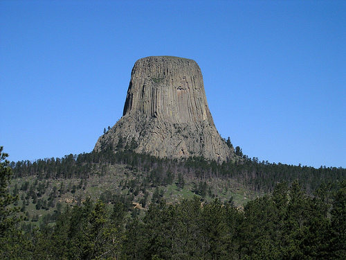
Devil's Tower National Monument is located in Crook County, Wyoming in United States. Devil's Tower National Monument is a unique geologic formation known as a laccolithic butte composed of igneous rock. It was formed as a plug in a former volcano. Lava made its way to the surface of the volcano and solidified. Over thousands of years remains of the mountain underwent erosion leaving this majestic monument to natural beauty. Lakota Native tribes called this notable formation Matho Thipila (literally "Bear Lodge") or Ptehe Gi ("Buffalo Horn"). It reaches a height of 865 ft (265 m). Devil's Tower is a popular destination of with mountain climbers that dare to make up its vertical slopes every year.
The landscape surrounding the Devil's Tower
consists mainly of sedimentary rocks. The oldest rocks visible in
the National Monument were in a shallow sea during the Middle or
Late Triassic period, 225 to 195 million years ago. This dark red
sandstone and garnet siltstone, interspersed with slate, can be seen
along the Belle Fourche river. Oxidation of iron minerals causes
reddening of the rocks. This layer of rock is known as the Spearfish
Formation. On the Spearfish Formation there is a thin band of
gypsum, called Gypsum Springs Formation. This layer of plaster was
deposited during the Jurassic period, 195 to 136 million years ago.
Created as sea levels and climates changed repeatedly, grayish
shales (deposited in low oxygen environments such as salt marshes)
were interspersed with fine-grained sandstones, limestones, and
sometimes fine beds of red clay.
During the Paleocene era, 56
to 66 million years ago, the Rocky Mountains and the Black Hills
rose. The magma ascended through the crust and intruded the layers
of existing sedimentary rocks. The igneous material that forms the
Devil's Tower is a phorolytic porphyrid intruded some 40.5 million
years ago, in the Eocene, As the magma cooled and its volume
decreased, cracks formed at predominant angles of 120 degrees,
forming the hexagonal columns (sometimes of 4, 5 and 7 sides), each
of about 180 cm in diameter.
The mass of igneous rock,
already crystallized, did not manifest itself in the landscape until
the sedimentary rocks that covered and surrounded it eroded. As the
elements eroded the softer sandstones and shales, the more resistant
igneous rock resisted the erosion forces to a greater extent. As a
result, the gray columns of the Devil's Tower began to appear as an
isolated mass highlighting the landscape.
Park entrance fees are $10 for a private vehicle,
or $5 for a hiker, bicyclist or motorcyclist. All entrance fees are
valid for seven consecutive days.
There are several passes
for groups traveling together in a private vehicle or individuals on
foot or on bike. These passes provide free entry at national parks
and national wildlife refuges, and also cover standard amenity fees
at national forests and grasslands, and at lands managed by the
Bureau of Land Management and Bureau of Reclamation. These passes
are valid at all national parks including Devils Tower National
Monument:
The $80 Annual Pass (valid for twelve months from
date of issue) can be purchased by anyone. Military personnel can
obtain a free annual pass in person at a federal recreation site by
showing a Common Access Card (CAC) or Military ID.
U.S. citizens
or permanent residents age 62 or over can obtain a Senior Pass
(valid for the life of the holder) in person at a federal recreation
site for $80, or through the mail for $90; applicants must provide
documentation of citizenship and age. This pass also provides a
fifty percent discount on some park amenities. Seniors can also
obtain a $20 annual pass.
U.S. citizens or permanent residents
with permanent disabilities can obtain an Access Pass (valid for the
life of the holder) in person at a federal recreation site at no
charge, or through the mail for $10; applicants must provide
documentation of citizenship and permanent disability. This pass
also provides a fifty percent discount on some park amenities.
Individuals who have volunteered 250 or more hours with federal
agencies that participate in the Interagency Pass Program can
receive a free Volunteer Pass.
4th graders can receive an Annual
4th Grade Pass that allows free entry for the duration of the 4th
grade school year (September-August) to the bearer and any
accompanying passengers in a private non-commercial vehicle.
Registration at the Every Kid in a Park website is required.
In
2018 the National Park Service will offer four days on which entry
is free for all national parks: January 15 (Martin Luther King Jr.
Day), April 21 (1st Day of NPS Week), September 22 (National Public
Lands Day), and November 11 (Veterans Day weekend).
The Devils Tower protrudes from a plateau of Mesozoic
sedimentary rocks, in which, in addition to clay and siltstones from the
Triassic (Spearfish Formation), primarily gypsum-rich layers of the
Middle Jurassic (Gypsum Springs Formation) and predominantly clay,
siltstone and sandstone from the later Jurassic (Sundance Formation,
Morrison Formation) and early Cretaceous (Inyan Group, Skull Creek
Shale, Newcastle Sandstone, Mowry Shale).
The Devils Tower itself
consists entirely of the alkaline volcanic rock phonolite ("phonolite
porphyry", in older literature trachyte). It is significantly younger
than the surrounding sedimentary rocks and was formed about 50 million
years ago in the Eocene, during the Laramic orogeny, as a result of
plate tectonic processes in western North America: the pressure exerted
on the western edge of the North American platform led to the dome-like
uplift of the Precambrian and Paleozoic rocks of the Black Hills from
underground. Accompanying uplift was alkaline magmatism confined to the
northern portion of the Black Hills Uplift and thought to be associated
with the reactivation of a deep-seated Precambrian basement fault (the
northwestern extension of the Sage Creek fault) known as the Ascent path
for, among other things, that magma could have served from which the
Devils Tower emerged.
After this magma made room and resided in
the Mesozoic sediments, it cooled and solidified into rock. Due to the
decrease in volume during the solidification process, a very regular
pattern of shrinkage fissures formed, which divided the rock into
columns (lava columns). These columns are predominantly hexagonal in
cross-section. But there are also columns with pentagonal and
quadrangular cross-sections. Whether some of this magma ever reached the
Earth's surface, or how close it came, is unclear. Therefore, it cannot
be answered whether Devils Tower is a "neck", i.e. a plug in the vent of
a volcano, or whether there is laccolite that solidified at a greater
distance from the earth's surface. The laccolith hypothesis is supported
by the fact that there are no traces of surface volcanism in the
surrounding area. However, volcanic ash and lava flows and other
indications could simply no longer be available today due to interim
erosion. About three miles northwest of the tower are the Missouri
Buttes, a group of much smaller volcanic hardlets of trachyte and
phonolite that are about 50 million years old, about the same age as
Devils Tower. However, both the Missouri Buttes and Devils Tower are
tiny in terms of footprint compared to the volcanic complexes in the
Bear Lodge Mountains and the Black Hills proper further to the
southeast.
In the further course of the Cenozoic, large areas of
Palaeogene and late Cretaceous sediments were removed from the Black
Hills region (denudation). Since Devils Tower consists of significantly
more erosion-resistant rock than the surrounding and probably originally
covering layers, it was dissected from the surrounding area and shaped
into its current shape. It towers above its immediate surroundings by
about 265 m and the bed of the Belle Fourche River by about 385 m. Its
highest point is 1559 m above sea level. The stump is surrounded by
scree slopes composed of phonolite fragments and brecciated surrounding
rocks.
Much of the plateau overlooked by Devils Tower is
covered with a forest of predominantly yellow pine. Originally, the
region was loosely forested. Decades of suppressing wildfires have left
forests unnaturally dense today. The National Park Service has been
intentionally setting small fires in the reserve at appropriate times
since the 1990s to rejuvenate and open up the forests.
Native
American Myths
The striking shape of the mountain makes Devils Tower
an object of Native American mythology. Under the Native American Graves
Protection and Repatriation Act (NAGPRA) of 1990, all peoples who have
ever been associated with the northeastern Wyoming region were asked
whether their lore included Devils Tower. In the study published in
1993, 21 peoples said they had cultural ties to the mountain.
The
Kiowa Indians call Devils Tower "Tso-aa" (English Tree Rock, "tree
rock", probably because it towers like a tree). According to their
legend, the mountain was formed when their ancestors built a village in
this area. One day seven little girls were playing some distance from
the village. They were spotted by several bears and the girls rushed to
the village. However, the bears reached the girls far before the
village. In their distress, the girls climbed onto a small boulder. They
begged the stone: "rock, have pity on us, rock save us". The rock heard
the girls and began to grow taller. The bears jumped at the rock in
their anger, broke out huge boulders and scratched deep grooves and
crevices in the rocks with their claws, but they could not reach the
girls. The rock grew and grew up into the sky. The girls are still in
heaven as seven little stars in the firmament: the Pleiades.
The
Lakota and Dakota Indians of the Sioux family associate Devils Tower
with White Buffalo Woman. She is said to have given them the Holy
Whistle and the Seven Rites of the Nations at this place. To this day,
the whistle is said to lie in a secret cave on the south side of the
mountain.
For the Cheyenne, Devils Tower is where their legendary
hero, Sweet Medizine, deposited the four sacred arrows in a secret cave
on the north side of the mountain. He also died on the mountain, which
is why the Cheyenne honor him in ceremonies here.
Various peoples of the Sioux, Cheyenne, Kiowas, Crow,
Arapaho, Blackfoot and others used the northern prairies for hunting. As
the whites advanced westward, more and more Indians who had formerly
settled further east were pushed into the Great Plains beneath the Rocky
Mountains.
Trappers worked in the area from the 1830s, but there
are no records describing Devils Tower. Expeditions to the Black Hills
in 1855 and 1857 probably did not come within sight of the mountain,
although a chronicler in 1857 recorded seeing Bear Lodge and the Little
Missouri Buttes Mountains through binoculars. But he probably referred
to a chain of hills north of the Tower.
In 1859, two members of
Capt. W. F. Raynolds in the Yellowstone area made a detour to Devils
Tower and were the first whites to be recorded as seeing it. Detailed
records were made by a surveying expedition in the summer of 1875:
"To be [i.e. des Towers] remarkable structure, its symmetry and its
exposed location make it an inexhaustible source of amazement. [...] It
is a large, remarkable trachyte obelisk with a columnar structure giving
it a striated appearance, and it rises 190 meters almost vertically from
the base. Its summit is so utterly inaccessible that an energetic
explorer, for whom climbing an ordinary mountain is a pleasant pastime
when standing at its base, can only look up with no hope of ever setting
foot on it.”
– Henry Newton, geologist of the 1875 expedition
Colonel Richard I Dodge, commander of the expedition's military escort,
was the first to name the mountain Devils Tower in his 1876 book on the
Black Hills. In his official report, Newton explained the naming in 1880
with the fact that although the Indian name Mateo Tepee was on the old
maps as Bear Lodge, bad god's tower ("Tower of the Evil God") was the
common translation for the expression of the Indians in of the region.
Devils Tower was chosen as a more elegant translation. This is now
considered a mistranslation.
In the 1868 Treaty of Fort Laramie,
the region was given to the Lakota. George Armstrong Custer violated the
treaty when he went on a military expedition to explore the Black Hills
and found gold in 1874. The reports attracted settlers and prospectors
who settled illegally. In 1875 the army gave up trying to hold back the
invaders. The Indians defended their hunting ground and the following
year began one of the last major battles of the Indian Wars, culminating
in the Battle of the Little Bighorn in June 1876, about 150 miles
northwest of Devils Tower, with the defeat and death of Custer. Despite
this victory, the Lakota Sioux, Cheyenne, and Arapaho were forcibly
evicted onto reservations in the fall of that same year.
The area
was officially opened to settlers from 1880, the little gold rush was
already over. There were initial plans to use the mountain as a quarry,
after which a conservation area was considered. In 1891, Devils Tower
was provisionally secured as part of a forest reserve, but the reserve
was reduced under settlement pressure and abolished altogether in 1898.
That same year, Senator Francis E. Warren introduced a bill that would
create a Devils Tower National Park. The plan was referred to committee
and not pursued further.
In 1906, the Antiquities Act came into
force, giving the President of the United States the right to designate
federal objects of scientific interest as national monuments without the
approval of Congress. President Theodore Roosevelt was persuaded that
Devils Tower must be preserved, and in September 1906 used his new
competence for the first time to place the mountain under protection.
During the Great Depression, the Civilian Conservation Corps built
the cul-de-sac and the first visitor center and other facilities in
1935-38. This made Devils Tower easier to reach and better known.
On October 1, 1941, stuntman George Hopkins parachuted from an
airplane without notification or permission and landed on Mt. Some of
his equipment was lost on landing, the rope he needed for the descent
fell off the side of the mountain and was out of reach for him. A team
of climbers led by Jack Durrance, who first ascended the route named
after him in 1938 (see below), came to Devils Tower from the west coast
and brought down Hopkins on October 7th. This had meanwhile been
supplied with food and blankets dropped by planes. The rescue operation
was a national media spectacle.
In the early 1960s, the monument
was expanded to what it is essentially today. Mission 66 created a
campground in the Belle Fourche River Bend, along with hiking trails and
information boards, in preparation for the 50th anniversary of the
National Park Service.
The first known ascent to the Tower was in 1893, but
not by traditional climbing. William Rogers and Willard Ripley,
neighborhood ranchers, spent days building a ladder of stakes that they
hammered in a continuous crack and connected with willow poles. On July
4, 1893, to celebrate Independence Day, Rogers and a large number of
neighbors, including women, climbed the mountain using the ladder. The
ladder remained functional until 1927, weathered remains can still be
seen today.
In 1937, three climbers from the American Alpine
Club, Fritz Wiessner with William P. House and Lawrence Coveney, were
the first to reach the summit using modern climbing techniques. Wiessner
led the entire route in free climbing and only made one hook, which he
later regretted because he thought it was superfluous. A year later, in
September 1938, the second ascent of the tower by Jack Durrance and
Harrison Butterworth took place. The Durrance route is a few dozen
meters to the left of the Wiessner route, is about the same difficulty
(according to the American difficulty scale 5.7) and is the most popular
today, but should not be underestimated. American climbers call them
underrated. Almost all the cracks between the phonolite columns have now
been climbed.
The Conservation Visitor Center at the end of the
cul-de-sac features exhibits on geology, natural history and the culture
of the area's Plains Indians. There are also regular guided hikes from
here and rangers give short presentations about the area.
In
addition to hiking on the circular trail at the foot of the rock
monument and other trails in the area, free climbing at Devils Tower is
a popular use of the sanctuary. To reduce conflicts with Native
Americans who hold the mountain sacred and who reject climbers, the
National Park Service is asking that climbing be avoided during the
month of June because this is the time of year when Native American
celebrations are particularly high in the sanctuary and region. Climbers
have had to register at the visitor center since 2006, solo attempts are
prohibited. When visiting the area for the first time, climbers must
view an introductory film about the mountain's cultural significance to
Native Americans.
Devils Tower gained international fame through
the 1977 film Close Encounters of the Third Kind. The finale of Steven
Spielberg's feature film was shot here. The Devils Tower appeared there
to several people in visions, a field right next to the monument served
as a landing base for alien spaceships. In the science fiction film
comedy Paul - Alien on the run from 2011, the final scenes also play
near the rock monument.
In early August, the mountain is visited
by thousands of motorcyclists en route to the Sturgis Motorcycle Rally
in Sturgis, 130 km away. These days see the area's highest visitor
numbers most years.