Location: Teton County, WY Map
Area: 310,044 acres (125,470 ha)
Grand Teton
National Park is a national park in the United States, in
northwestern Wyoming. It has an area of about 130,000 hectares
and includes most of the Teton mountain range and the northern
part of the Jackson Hole valley. Grand Teton is located just 10
miles south of Yellowstone National Park. The two parks are
connected by an area known as the Memorial Alley. John Davison
Rockefeller, which is also managed by the Grand Teton Park
Authority. The territories of both national parks, as well as
the national forests and other protected areas adjacent to them,
form the Greater Yellowstone Ecosystem, with an area of
approximately 7,300,000 hectares, which is one of the largest
remaining mid-latitude ecosystems in the world.
The first
people appeared on the territory of the modern park about 11,000
years ago. They were nomads, hunters and gatherers who migrated
to the region during the warm months of the year in order to
find food and material for making tools. At the beginning of the
19th century, the first Europeans came to the Teton Range
region, who met here the eastern tribes of the Shoshone. In the
period from 1810 to 1840, several expeditions of trappers
visited the region. Organized expeditions funded by the US
government began only in the second half of the 19th century, as
additional offshoots of expeditions sent to the Yellowstone
River. The first settlers appeared in the Jackson Hole valley
only in the 1880s. Grand Teton National Park was created in 1929
and includes most of the Teton Range. The Jackson Hole valley
was privately owned until the 1930s, when the land there began
to be bought by John Davison Rockefeller Jr. with a view to
transferring it to the national park. Despite the fact that
public opinion and Congress were against it, in 1943 the Jackson
Hole National Monument was declared in the valley. The natural
monument became part of the Grand Teton National Park in 1950.
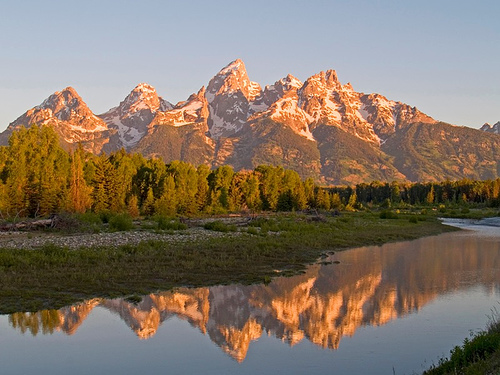
The park takes its name from the highest mountain in the
Teton Range, which is 4,199 meters above sea level and 2,100
meters above Jackson Hole. There are numerous lakes on the
territory of the park, the largest of which, Jackson, has a
length of 24 km. The largest river in the park is the Snake,
which receives all the streams flowing from the mountains into
the Jackson Hole valley. There are more than 10 small glaciers
in the area of the Teton Ridge. The nature of the park is in an
almost untouched state. Grand Teton is home to over 1,000
vascular plant species, 300 bird species, 61 mammal species, 4
reptile species, 6 amphibian species, and thousands of insect
species. The park is a popular place to visit and offers a
variety of activities. There is a developed tourist
infrastructure, including more than 1,000 campsites, 320 km of
hiking trails, several information centers and guest complexes.
All vehicles and individuals entering the Grand
Teton National Park must pay an entrance fee that is valid for seven
days. The fee is $30 for non-commercial vehicles, $15 for hikers and
cyclists, and $25 for motorcycles. As an alternative to the
seven-day fee, you can buy a Park Annual Pass, which costs $60 and
is valid until the end of the month 1 year after the purchase date.
If you plan to visit both Grand Teton and Yellowstone National
Parks, you can pay a single entrance fee for both at a discount
compared to paying two separate fees for the two parks. The combined
fee is $50 for non-commercial vehicles, $20 for hikers and cyclists,
and $40 for motorcycles and snowmobiles.
There are several
passes for groups traveling together in a private vehicle or
individuals on foot or on bike. These passes provide free entry at
national parks and national wildlife refuges, and also cover
standard amenity fees at national forests and grasslands, and at
lands managed by the Bureau of Land Management and Bureau of
Reclamation. These passes are valid at all national parks including
Grand Teton National Park:
The $80 Annual Pass (valid for
twelve months from date of issue) to Grand Teton National Park can
be purchased by anyone. Military personnel can obtain a free annual
pass in person at a federal recreation site by showing a Common
Access Card (CAC) or Military ID.
U.S. citizens or permanent
residents age 62 or over can obtain a Senior Pass (valid for the
life of the holder) in person at a federal recreation site for $80,
or through the mail for $90; applicants must provide documentation
of citizenship and age. This pass also provides a fifty percent
discount on some park amenities. Seniors can also obtain a $20
annual pass.
U.S. citizens or permanent residents with permanent
disabilities can obtain an Access Pass (valid for the life of the
holder) in person at a federal recreation site at no charge, or
through the mail for $10; applicants must provide documentation of
citizenship and permanent disability. This pass also provides a
fifty percent discount on some park amenities.
Individuals who
have volunteered 250 or more hours with federal agencies that
participate in the Interagency Pass Program can receive a free
Volunteer Pass.
4th graders can receive an Annual 4th Grade Pass
that allows free entry for the duration of the 4th grade school year
(September-August) to the bearer and any accompanying passengers in
a private non-commercial vehicle. Registration at the Every Kid in a
Park website is required.
In 2018 the National Park Service will
offer four days on which entry is free for all national parks:
January 15 (Martin Luther King Jr. Day), April 21 (1st Day of NPS
Week), September 22 (National Public Lands Day), and November 11
(Veterans Day weekend).
Grand Teton National Park is a bit
curious in that the ranger stations where you pay the entry fees lie
fairly deep within the park. This essentially means that sections of
the park can be accessed for free, including Jackson Hole Airport.
The first evidence of the presence of Paleo-Indians in the territory
of the modern park dates back to a period of more than 9000 BC. e. The
climate in the Jackson Hole region was at that time more alpine and
colder than it is today. The first people to come to these places were
hunters and gatherers who spent the summer months in the Jackson Hole
valley and migrated to the valleys west of the Teton Range for the
winter. Numerous tools have been found along the shores of Jackson Lake,
one of which is of the same type as those of the Clovis culture, and
evidence of the presence of this culture usually dates back to at least
9.5 thousand years BC. Some of the tools are made from obsidian, which
chemical analysis has shown was mined near present-day Teton Pass, south
of Grand Teton Park. Although obsidian can also be mined north of
Jackson Hole, all spear points found were obtained from obsidian from
the south, which proves that the seasonal migrations of the
Paleo-Indians took place in this direction. It can also be noted that
moose in this region retain similar migration routes to this day. For
the entire period from 9000 BC. e. before 1500 AD there is very little
evidence of a change in the migration routes of the indigenous
population of the region, and there is also no evidence of the existence
of permanent settlements.
When the first American explorers and
pioneers came to the Grand Teton area in the first decade of the 19th
century, they encountered the eastern Shoshone tribes. Most of the
Shoshone living in the mountains at that time did not use a horse, while
the tribes living below, in the valleys, used horses to a rather limited
extent. Shoshone living in the mountains were known as "ram-eaters" or
"tukudika", as they called themselves, which is explained by the fact
that the basis of their diet was bighorn sheep. The Shoshone continued
to use the same migration routes as their ancestors. The presence of a
certain spiritual connection of the Shoshone with the Teton Range is
also noted. The Shoshone from the Teton and Yellowstone areas were moved
to the Wind River Reservation after it was established in 1868. The
reservation is located 100 miles south of Jackson Hole, on land chosen
by Chief Washakie.
The Lewis and Clark Expedition of 1804-06 passed north of the Grand
Teton region. During their return from the Pacific coast, one of the
expedition members, John Colter, joined two trappers who were heading
west for beaver skins. Colter was also subsequently hired by Manuel Lisa
to lead a group of trappers and explore the region along the Yellowstone
River. In the winter of 1807-08, Colter passed through Jackson Hole and
was probably the first non-native to see the Teton Range. In mapping out
the results of the expedition undertaken, William Clark also used data
obtained by Colter after they met in St. Louis in 1810. Another Clark
map shows that John Colter entered Jackson Hole from the northeast,
crossed the Continental Divide either at Toguoti or Union Pass, and left
the region at Teton Pass. The "Colter Stone" (a stone carved in the
shape of a head with "Colter" on one side and "1808" on the other) was
discovered in 1931 in a field in the town of Tetonia, Idaho, west of
Teton Pass. There is no evidence that the "Colter Stone" was actually
created by John Colter, and not by the numerous expeditions that passed
through the region after him.
John Colter is generally regarded
as the first mountain man and, like all those who passed through Jackson
Hole in the following three decades, he organized his expeditions
primarily to find places rich in furs. Astor's expedition passed through
the Teton Pass and emerged from the east side of the valley in 1812.
After 1810, American and British trading companies competed to control
the North American fur trade. The end of competition in this region was
put by the Oregon Treaty of 1846, which declared this territory part of
the United States. The expedition, organized by the British North West
Company and led by the pioneer Donald Mackenzie, was undertaken in
1818-19. Many of the region's geographic features were probably named by
French-speaking Iroquois or Canadian trappers of French origin during
the Mackenzie Expedition. The French name "Le Trois Teethons" was
subsequently shortened to "Teethons".
In 1820, the Rocky Mountain
Fur Company was formed, led by Jedediah Smith, William Sublett, and
David Edward Jackson. From 1826 to 1830, Jackson led trapper expeditions
to the Teton region. It was in his honor that Sublette named the valley
east of the Teton Range "Jackson Hole". Meanwhile, demand for beaver
began to decline, and many areas of the American West were almost
completely devoid of beaver due to overhunting. This led to the ruin of
many fur companies, although individual trappers continued beaver
hunting until 1840. From the mid-1840s until the 1860s, the Teton Ridge
and Jackson Hole Valley were almost completely devoid of population,
with the exception of a small group of indigenous people who still
remained here. Migration trails such as the Oregon and Mormon trails
crossed the watershed through South Pass. Thus, European influence in
the Grand Teton region was minimal until organized expeditions funded by
the US government.
The first organized expedition to enter Jackson Hole was the Reynolds
Expedition of 1859-60. Led by US Army Captain William Reynolds, the
expedition included their guide, mountain man Jim Bridger, as well as
geologist Ferdinand Hayden, who would himself lead several expeditions
to the region. The expedition was tasked with exploring the Yellowstone
region, but encountered a number of difficulties in crossing the passes
due to the large amount of snow. Bridger led the expedition south,
through the Union Pass and then along the Gros Ventre River, after which
he led the expedition out of the region through the Teton Pass. The
expeditions were stopped for the period of the Civil War, but again
resumed by Hayden in 1871. In 1872, Hayden was conducting geological
surveys in the Yellowstone area, and part of his expedition, led by
James Stevenson, explored the Teton region. Stephenson was accompanied
by photographer William Henry Jackson, who took the first photographs of
the Teton mountain range. Hayden's expedition gave names to many
mountains and lakes in the region, but never found any economically
significant mineral deposits. However, small groups of prospectors
subsequently mined some of the streams and rivers in the region. By
1900, any attempt to find minerals here was abandoned. The first
settlers began to settle in the Jackson Hole Valley, east of the Teton
Range, in 1884. They were mostly single men who experienced long winters
and rocky soil that was difficult to work. The basis of the life of
these people was the harvesting of hay and cattle breeding. By 1890, the
resident population of the Jackson Hole Valley numbered only 60 people.
The Menorah Crossing of the Snake River was established in 1892, near
the modern town of Moose, and provided wagons with the opportunity to
cross to the west bank of the river. The number of settlers increased
significantly between 1890 and 1920, but the decline in the agricultural
industry in the early 1920s left many settlers without a livelihood and
forced them to leave the region. In the 1920s, the roads leading into
the Jackson Hole valley through the Teton and Tonguoti passes were
improved to accommodate the increased traffic. The tourism industry
began to develop in the region.
Creation of a national park
Yellowstone National Park, located north of Grand Teton, was established
in 1872, and in the late 19th century, many environmentalists advocated
expanding the park to include the Teton Range. In 1907, the US Bureau of
Reclamation builds a dam on the Snake River, near the point where it
flows out of Lake Jackson. The dam broke already in 1910, after which,
in 1911, it was replaced by a new dam. In 1916, the dam was again
increased in size, due to which the level of Lake Jackson rose another
12 meters. The dam was built as part of the Minidoka Project to provide
irrigation to fields in Idaho. Further plans to build dams near other
lakes in the Teton Ridge area have alarmed Yellowstone Park Manager
Goris Albright, who has taken various steps to halt these plans. The
population of the Jackson Hole Valley was against the expansion of
Yellowstone Park, but positively perceived the idea of creating a
separate park, including the Teton Range and six lakes at the foot of
the mountains. After Congressional approval, President Calvin Coolidge
signed an executive order creating the 39,000-hectare Grand Teton
National Park on February 26, 1929.
When John Davison Rockefeller
Jr. visited the area in the late 1920s, most of Jackson Hole was still
privately owned. Goris Albright and Rockefeller discussed ways to keep
the valley from commercial activity, after which Rockefeller began
buying property in Jackson Hole through the Snake River Land Company
with a view to its subsequent transfer to the US National Park Service.
In 1930, this plan was presented to the population of the region and met
with strong disapproval from them. The US Congress, in turn, is making
every effort to prevent the expansion of the park. By 1942, Rockefeller
was extremely excited that the property he had purchased would never be
included in the national park. He writes to the US Secretary of the
Interior, Harold Ickes, that he is considering selling the land to
another party. Ickes recommends that the country's president, Franklin
Roosevelt, use a bill that allows the president to create a protected
area without congressional approval, which was used to proclaim Jackson
Hole a national natural monument. Roosevelt creates a 89,000-hectare
National Natural Landmark in 1943 using land donated by the Snake River
Land Company and adding additional land from the Teton National Forest.
The territory of the natural monument and the national park adjoined
each other and were managed by the park administration, however, the
level of environmental protection in the natural monument was an order
of magnitude lower. In addition, members of Congress repeatedly tried to
cancel the decree establishing a new natural monument.
After the
Second World War, public opinion was in favor of joining the natural
monument to the national park and, despite opposition from local
authorities, in 1950 the monument was attached. In 1972, a 9,700-hectare
tract of land between Grand Teton and Yellowstone was transferred to the
US National Park Service. In gratitude to Rockefeller, this site and the
road passing through it were named Memorial Alley. John Davison
Rockefeller. In addition, the Rockefeller family owned a ranch on the
southern boundary of the park, which they handed over to the park
administration in 2007, after which, on June 21, 2008, the Lawrence S.
Rockefeller Conservation Area was established in this area.
During the last quarter of the 19th century, the Teton Ridge became a
popular destination for climbers who wanted to make their mark on the
summits. However, all these people were probably not the first, and even
the top of Grand Teton was conquered long before that by the indigenous
population of the region. Evidence of this includes various traces of
human presence here, one of which is a structure known as The Enclosure,
located about 160 m below the summit of Grand Teton. Members of the
Hayden Expedition of 1872, Nathaniel Langford and James Stevenson,
discovered the Fence during their early attempts to climb to the summit.
They reported reaching the summit of Grand Teton, however this claim is
still controversial. The information reported by them has not been
confirmed by subsequent expeditions, and there is reason to believe that
in fact Langford and Stevenson did not advance above the "Fence". The
first confirmed ascent of the mountain was by William Auen, Frank
Peterson, John Shiv and Franklin Spencer Spalding on August 11, 1898.
Auen, in his notes, discredited Langford and Stevenson's claim and
stated that in 1872 they had only reached the "Fence". The disagreement
between groups over who first reached the summit of Grand Teton is
perhaps the largest dispute in the history of American mountaineering.
From 1898 to 1923, there was no recorded ascent to the summit of Grand
Teton.
By the mid-1930s, more than a dozen routes had been
developed to climb Grand Teton, including the northeast ridge route
climbed by Glenn Exum in 1931. All other significant peaks of the range
were also conquered by the end of the 30s, including Mount Moran (in
1922) and Mount Auen (in 1930). The summits of Middle Teton and South
Teton were conquered on the same day, August 29, 1923, by a group of
climbers led by Albert Ellingwood.
Grand Teton Park is one of the ten most visited national parks in the
United States with an average annual visitor count of 2.5 million. The
National Park Authority is a federal agency of the US Department of the
Interior; she is in charge of the national park itself and the memorial
alley to them. John Davison Rockefeller. The national park maintains an
average of 100 permanent and 180 seasonal workers. In addition, the park
has entered into 27 agreements with organizations providing various
types of services on its territory, such as providing meals and
accommodation for visitors, mountaineering, fishing, water taxis on Lake
Jenny, etc. In addition, the park works in close cooperation with such
federal agencies such as the US Forest Service, the US Fish and Wildlife
Service, the Bureau of Reclamation, and also, due to the fact that
Jackson Hole Airport is located on the territory of the park, with the
US Federal Aviation Administration. Initially, the construction of an
airstrip north of the city of Jackson began in the 1930s. When the
Jackson Hole National Natural Monument was founded, the strip ended up
on its territory, and subsequently - on the territory of the park. Thus,
Jackson Hole becomes the only commercial airport located in the US
National Park. The airport implements some of the most stringent noise
reduction regulations of any airport in the country.
As of 2010,
there are 110 private properties in the national park, most of which
belong to the state of Wyoming. In partnership with other organizations,
attempts continue to acquire or exchange these objects for other federal
lands. The $10 million currently available for acquisition is likely to
be increased by 2016. Attempts to exchange private property for other
federal states as of 2012 are still under negotiation.
Grand Teton National Park is located in northwestern Wyoming. In the north, the territory of the park borders on the Memorial Alley. John Davison Rockefeller, which is also managed by the park administration. The highway of the same name starts at the southern border of Grand Teton Park and connects it to Yellowstone Park. The National Park covers an area of 130,000 hectares, while the National Alley has an area of 9,600 hectares. The park contains much of the Jackson Hole Valley and the Teton Range. Along the western border of the park are the wasteland. Jedediah Smith and the Caribou-Targa National Forest, which include the western slopes of the range. To the northeast and east of the park are the Teton and Gros Ventre wastelands, as well as the Bridger Teton National Forest. The elk reserve is located southeast of the park and is a wintering place for the local elk population. From the south and southwest, the park borders on private lands. Together with Yellowstone National Park and other adjacent protected areas, Grand Teton Park is part of the Greater Yellowstone Ecosystem with a total area of 7,300,000 ha (73,000 km²). The Greater Yellowstone is one of the largest intact mid-latitude ecosystems on Earth. Grand Teton National Park is located 470 km by road from Salt Lake City, Utah and 890 km from Denver, Colorado.
Being the youngest range of the Rocky Mountains, Teton began to form
only 6-9 million years ago. The ridge runs almost exactly in the
meridional direction along the active fault. The eastern slopes drop
steeply towards Jackson Hole, while the western slopes slope more gently
towards the Teton Valley. The western fault block rises, while the
eastern one descends, moving an average of 0.3 m every 300–400 years.
Most of this shift has taken place over the past 2 million years.
However, although the fault has experienced earthquakes of magnitude 7.5
since its formation, it has been relatively quiet during the historical
period, and after 1850 only a few earthquakes of magnitude 5.0 or more
have been recorded.
In addition to the summit of Grand Teton,
which is 4199 m above sea level, there are 9 other peaks in the range
with a height of more than 12,000 feet (3658 m). 8 of these peaks,
located between the Avalanche and Cascade canyons, form the fairly
well-known Cathedral Group. North of Cascade Canyon is Mount Moran,
which rises 3,842 meters above sea level and 1,746 meters above Lake
Jackson. North of Mount Moran, the ridge gradually transitions into the
Yellowstone High Plateau. South of the Cathedral Group, the Teton Range
narrows near Teton Pass and joins the Snake River Range. The canyons,
running west and east, are the most convenient way to get to the central
part of the range on foot, where there are no roads except for the one
that passes through Teton Pass, south of the park. Descending from
higher areas, the glacier created more than a dozen U-shaped valleys in
the ridge area.
Jackson Hole is a valley formed by a graben. It is 89 km long, 9.7 to 21 km wide and has an average altitude of 2100 m above sea level. The valley has an almost flat relief with a gradual slight increase in elevation in the direction from south to north. The lowest part of the valley is 1940 m above sea level and is located near the southern border of the park. At the same time, there are several remnants at the bottom of the valley, such as Blacktail and hills, such as Signal. In addition to these irregularities, the geological activity of the Snake River has formed terraces in the Jackson Hole valley. There are numerous glacial depressions southeast of Lake Jackson.
Most of the lakes located in the park are located at the foot of the
ridge and are of glacial origin. The largest lake in the park is Jackson
Lake, which is located in its northern part and is 24 km long, 8 km wide
and 134 m deep. However, although the lake is natural, the Snake River
that flows from it was dammed before the park was formed, causing the
lake to rise 12 m. Ocean. South of Lake Jackson are Lakes Laig, Jenny,
Bradley, Taggart and Phelps, which are located in the spurs of the
canyons. In the region of the Titon Ridge there are many small lakes
located in kars - bowl-shaped basins in the near-surface part of the
mountains. So, Solitude Lake is located in a square at the top of the
Cascade Canyon, at an altitude of 2754 m. Other high-altitude lakes are
located at an altitude of more than 3000 m, and a few, such as Iceflow
Lake, are ice-bound for most of the year. There are no large waterfalls
in the national park. However, to the west of Jenny Lake there is a
small Hidden Falls waterfall, which is 30 m high.
Beginning in
the Two Oceans Plateau area of Yellowstone National Park, the Snake
River crosses Grand Teton Park from north to south as it flows through
Jackson Lake. There is a dam on the river below the lake, after which
the Snake continues to flow south through Jackson Hole, leaving the park
area west of Jackson Hole Airport. All other major lakes in the park
also flow either directly from the Snake River or its tributaries. The
largest tributaries of the Snake here are Pacific Creek and Buffalo
Creek near the town of Moran, as well as the Gros Ventre River - on the
southern border of the park. Descending through the Jackson Hole Valley,
the Snake River has a gradient of 19 feet per mile (5.8 m by 1.6 km),
while other rivers and streams descending into the valley from the
mountains have more significant gradients. In places where the gradient
is least, the Snake River creates channels and channels, and in places
where the gradient is maximum, it washes out terraces in the material
deposited by the glacier.
The modern features of the relief of the Teton Range were formed by the glacier. Starting from a period of 250,000-150,000 years ago, Teton experienced several periods of glaciation, when parts of the Jackson Hole valley were covered with a glacier that was more than 600 m thick. Glaciations have nothing to do with uplift of the area and are entirely the result of global cooling of the climate known as the Quaternary glaciation. During the last ice age, the glacier descended from the Yellowstone Plateau south to form Jackson Lake, and small spurs of the glacier descending from the Teton Range carried a large amount of detrital material, leaving it at the base of the mountains. In addition, the outlines of the canyons have been smoothed from V-shaped, formed by water erosion, to U-shaped, carved by a glacier. Today, there are about a dozen glaciers in the park, but all of them are not ancient, but were restored during the Little Ice Age 1400-1850 AD. The largest of the modern glaciers is the Titon Glacier, which is about 1100 m long and 340 m wide. The Teton is also the most studied glacier of the range; in 2005, researchers concluded that it could melt completely in the next 30-75 years. To the west of the Cathedral Group, near Hurricane Pass, is the small Sculrum Glacier, which, despite its small size, has all the features of a glacier, including moraines and a tiny periglacial lake.
The climate of the park is characterized as semiarid. The wettest months are from November to January, when precipitation falls mainly in the form of snow. On average, about 11,000 mm of solid precipitation falls annually in the mountains of the park, and about 4,900 mm in the valley. The average daily temperature in January is -3°C; average night: -17 °C. In July, the average daytime temperature is 27°C, and at night: 5°C. The highest temperature ever recorded is 34°C and the lowest is -54°C. In summer, starting from the level of the valley, the temperature in the mountains drops by an average of 1 °C for every 300 m; thus, high mountain passes may remain covered with snow until mid-July. Thunderstorms are frequent in the mountains of the park in summer; at the same time, tornadoes have never been recorded in the park. The 1987 Teton-Yellowstone F4 tornado affected only the northeast end of the park, passing through neighboring areas.
Flora
Over 1,000 species of vascular plants grow in Grand Teton Park and
surrounding areas. With a vertical drop of more than 2100 m, the
national park is located in several natural areas, including: alpine
meadows, the subalpine zone of the Rocky Mountains with a predominance
of spruce-fir forests, as well as the bottom of the valley, where mixed
and broad-leaved forests grow. In addition, near some lakes and along
rivers there are wetlands with characteristic vegetation. Altitude, soil
type, forest fires, avalanches and human impacts, among other things,
directly influence the predominance of vegetation type in a given
location. Areas where natural areas overlap each other are examples of
ecotones.
The main factor determining the type of vegetation, of
course, is the elevation difference. Above the border of the forest,
which passes in this region at an altitude of about 3000 m, alpine
meadows are widespread. In this area devoid of trees, hundreds of
species of herbaceous plants, mosses and lichens grow. The subalpine
belt extends from the forest border to the foot of the mountains, the
predominant tree species here are whitebark pine, soft pine, subalpine
fir and Engelman spruce. The valley floor is dominated by lodgepole
pine; the most arid regions are occupied by gray pseudo-hemlock and blue
spruce, and areas near rivers, lakes and swamps are occupied by aspen,
poplar, alder and willow. There are also grassy areas with more than 100
species of herbs and wildflowers.
Although the flora of the park
is almost intact, tree species such as whitebark pine and soft pine are
at risk. The fact is that the invasive fungus Cronartium ribicola
weakens the trees, making them less protected from destruction by the
Dendrocton beetle (Dendroctonus ponderosae). Whitebark pine is most
common at altitudes above 2400 m; its cones are an important food source
for many animal species, including grizzly bears, red squirrels and
American nutcrackers. The prevalence of blister rust, which is spread by
the fungus Cronartium ribicola, is lower in Grand Teton than in some
neighboring regions, such as Glacier Park, but it is still somewhat
higher than in Yellowstone National Park. Despite typical hands-off
practices in U.S. national parks, the spread of the disease has prompted
several government agencies to take action to protect trees.
There are 61 species of mammals found in Grand Teton Park. These
include the wolf, which was completely extirpated from the region by the
early 1990s but migrated out of Yellowstone Park after the re-population
there. After the restoration of the wolf population, all indigenous
species of mammals characteristic of the area began to inhabit the park.
In addition to wolves, 17 more species of predators live in the park,
including the grizzly bear and the baribal, which is more common in
these places. The most typical predator species also include the coyote,
Canadian otter, American marten and American badger; less common are the
cougar, Canadian lynx, and wolverine. Rodents include the yellow-bellied
marmot, lesser chipmunk, muskrat, beaver, American pika, American hare,
and North American porcupine. There are 6 types of bats. Of the large
mammals, the elk can be noted, which lives here in large numbers. Moose
are quite easy to see at any time of the year, and especially easy in
spring and autumn. Other ungulates include the bison and the pronghorn,
the fastest mammal in the western hemisphere, which, like the elk, is
widespread throughout Jackson Hole and often found near rivers and
lakes. 100-125 bighorns live in the high-mountainous and rocky areas of
the park.
The park is home to over 300 bird species, including
North America's smallest bird, the calliope hummingbird, and the
continent's largest waterfowl, the trumpeter swan. In addition to the
trumpeter's swan, there are 30 more species of waterfowl, including the
blue-winged teal, large merganser, American wigeon, and kale. There are
such predatory species as the bald eagle, golden eagle, osprey,
red-tailed buzzard, kestrel and peregrine falcon. Of the 14 species of
owls living here, the Virginian eagle owl is the most common; There are
dozens of species of woodpeckers, plovers, gulls and songbirds. The
grassy plains of Jackson Hole are home to the sage grouse, Brewer's
bunting and the mockingbird Oreoscoptes montanus, while the wetlands are
typified by the great blue heron, the American white pelican, the
Sandhill crane, and the endangered American crane.
There are 4
species of reptiles in Grand Teton Park: 3 species of snakes, including
the garter snake and rubber snake, as well as 1 species of lizard - the
fence iguana Sceloporus graciosus, which was discovered here only in
1992. All of these species are non-venomous. There are 6 species of
amphibians in the park, including spotted frog (Rana luteiventris),
Pseudacris maculate, tiger ambystoma, western American toad (Bufo boreas
boreas) and leopard frog. The sixth amphibian species, the bullfrog, is
not native. The park contains at least 10,000 species of insects that
pollinate plants, serve as food for birds, fish, mammals and other
animals, and also participate in the decay of plant material. One
example of the importance of insects to the ecosystem are the moths
Euxoa auxiliaris, which die in huge numbers after mating and provide
bears and other predators with food rich in fats and proteins. Studies
show that when moths are especially abundant, bears consume up to 40,000
individuals per day, which corresponds to a value of 20,000 kcal / day.
Grand Teton is the only national park in the United States that
allows hunting of animals, but only if these animals are moose. This
provision was included in the park's law when it was merged with the
Jackson Hole National Monument in 1950. Although some Alaskan parks
allow hunting for the native population, and several other parks
sometimes establish areas where hunting is allowed for the purpose of
species regulation, Grand Teton's policy is still quite unique. Moose
hunting in the park is strictly regulated and is only allowed east of
the Snake River, and north of Moran City only east of Route 89. Moose
hunting advocates argue that the measure is forced, since without
shooting, the herd of moose will increase, which will affect vegetation
that will suffer from overgrazing. Opponents argue that predators have
increased in the park, and deer hunting is completely unnecessary and
potentially dangerous, especially since predators such as wolves and
grizzlies have become accustomed to eating the remains of carcasses left
after hunting.
Forest fires are of great ecological importance for plant and animal diversity. Many types of trees give new shoots mainly after fires. Parts of the park where wildfires have occurred in historical times are more biodiverse than areas where there were no fires. Although the Yellowstone Fire of 1988 caused little damage to Grand Teton Park, studies conducted before and after the fire showed that the fight against natural wildfires since the middle of the 20th century has had a negative impact on biodiversity and the natural regeneration of plant communities. Research conducted 15 years before the 1988 Yellowstone fire showed that human firefighting was particularly damaging to aspen groves, as well as several other forest types. Most coniferous species are also quite dependent on forest fires, especially broadleaf lodgepole pine. At the same time, too high temperatures and crown fires destroy pine seeds, while ground fires only promote regeneration. With a better understanding of the environmental role of wildfires, the National Park Service and other agencies have developed a plan that provides wildfire management strategies with minimal impact on natural ecosystems.
Grand Teton Park is located at a distance of more than 160 km from
the nearest large cities and industrial enterprises, so the human impact
on the region's environment can be considered minimal. However, the
levels of ammonia and nitrogen in the air are slightly elevated, due to
the deposition of rain and snow from agricultural regions. There is also
a slight excess of the level of mercury and pesticides in the snow and
water of mountain lakes. In 2011, Grand Teton National Park partnered
with other agencies to establish the park's first air quality monitoring
station. The station is designed to detect various air pollutants, as
well as to check ozone levels and study the weather.
A 2005 study
of the water quality of lakes Jackson, Jenny and Taggart showed that the
water in all three lakes is clean, although the indicators differed
slightly. Of these lakes, only Taggart Lake is prohibited from using
motor boats. Research conducted in 2002 showed that the Snake River
within the park has better water quality than any other river system in
Wyoming, with the lowest levels of anthropogenic pollutants.
Grand Teton Park has 5 campsites accessible by car. The largest of
these, Colter Bay and Gros Ventre, each contain 350 recreational sites,
capable of accommodating even large mobile homes. Lizard Creek and
Signal Mountain Campgrounds have 60 and 86 sites, respectively, while
the smallest campsite, Jenny Lake, has only 49 sites. All of these
campsites are open from late spring to late autumn; winter camping can
be visited in Colter Bay, near the information center. All parts of the
park that can only be accessed on foot or on horseback (backcountry
campsites) are accessible only by permit, but camping in most of these
places is allowed throughout the year. No fires are allowed in the
backcountry campsites, and all visitors' food must be stored in
bear-proof food containers approved for use in the park. It is also
allowed to use a bear spray to scare away aggressive bears.
The
park has 320 km of hiking trails of various difficulty levels. The
simplest routes pass entirely through the valley, where the elevation
difference is negligible. An example of such a route, located in close
proximity to Colter Bay, is Hermitage Point, which is 15.1 km long.
Several trails link Hermitage Point to the Emma Matilda Lake and Two
Ocean Lake trails, which are also considered easy trails. The Valley
Trail, which runs from Trapper Lake to the park's southern border, is
also easy, as is the Jenny Lake Trail, which runs around the lake of the
same name. The complexity of the routes depends more on the elevation
difference than on the distance. On the Paintbrush Canyon, Alaska Basin
and Garnet Canyon routes, the elevation difference is more than 1200 m.
The use of horses and beasts of burden is allowed on almost all routes.
The use of bicycles is restricted to highways; some roads have been
widened specifically to ensure the safety of cyclists.
The Craig-Thomas Information Center was opened in 2007 near the park
administration building in the village of Moose. The center was built
with government grants and private donations, and today is open all year
round. North of the village of Colter Bay, on the shores of Jackson
Lake, is the Colter Bay Center and Native American Art Museum, open from
early May to early October. Since 1972, the Museum of Indian Art has
housed an exhibition of David T. Vernon. The Information Center was
built in 1956 and in 2005 was found to be in poor condition to house a
collection of Native American art. The reconstruction was carried out in
the winter of 2011-12, and with the opening of the center in May 2012,
part of the exposition was already available to visitors. South of
Moose, on the Moose-Wilson Road, is the Lawrence S. Rockefeller Center,
which sits on the shores of Lake Phelps. This guest center is located in
the former ranch of the Rockefeller family. On the shores of Jenny Lake,
there is the Jenny Lake Center, open to visitors from mid-May to
mid-September.
Guest complexes
Housing for visitors in the
park is offered by several organizations that have signed a contract
with its administration and have guest complexes. The largest guest
complex is Jackson Lake, located near the Jackson Lake Dam and providing
visitors with 385 rooms, conference rooms, a store and a restaurant. The
same company operates the Jenny Lake and Colter Bay complexes, which
also offer several rooms, restaurants and some other services. South of
Jackson Lake Dam is the Signal Mountain Guest Complex, operated by
Forever Resorts and providing rooms, a restaurant, a gas station, and a
marina. The American Mountaineering Club has a hostel in the park
located on the Grand Teton Clumber Ranch. In addition to the above
complexes, some private buildings offer housing to park visitors.