Location: Fresno county, CA Map
Area: 462,901 acres (187,329 ha)
Official site
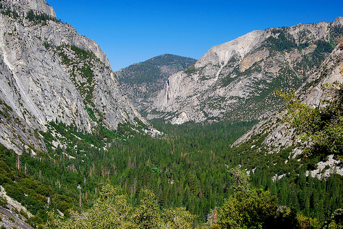
Kings Canyon National Park, located in California’s Sierra Nevada, spans 461,901 acres across Fresno and Tulare counties, encompassing some of the most dramatic and pristine landscapes in the American West. Established as General Grant National Park in 1890 and expanded as Kings Canyon National Park in 1940, it is managed by the National Park Service (NPS) alongside Sequoia National Park, with which it shares a boundary and administration. Renowned for its deep canyons, towering sequoia groves, alpine meadows, and rugged peaks, the park includes the 8,200-foot-deep Kings River Canyon—one of North America’s deepest—and iconic landmarks like General Grant Tree, the world’s second-largest tree. With 400 miles of trails, 80% wilderness, and peaks exceeding 14,000 feet, it draws 700,000 visitors annually (2023) for hiking, climbing, and awe-inspiring vistas.
Kings Canyon National Park lies 80 miles east of Fresno and 200 miles
north of Los Angeles, nestled in the Sierra Nevada’s western slope. It
borders Sequoia National Park to the south, with the John Muir and
Pacific Crest Trails linking the two. The park’s terrain is defined by:
Canyons: The South Fork Kings River Canyon, at 8,200 feet deep,
rivals the Grand Canyon for depth, with sheer granite walls and
waterfalls like Grizzly Falls. Middle Fork and Paradise Valley add
scenic gorges.
Peaks: 47 peaks exceed 13,000 feet, including North
Palisade (14,248 feet), the park’s highest, and Mount Goddard (13,568
feet). The Palisades and Evolution Basin are climbing hubs.
Sequoia
Groves: Grant Grove, home to General Grant Tree (268 feet tall, 40-foot
diameter), and Redwood Mountain Grove, the world’s largest sequoia grove
(3,100 acres), are iconic.
Alpine Basins: Rae Lakes, Evolution
Valley, and Dusy Basin feature turquoise lakes and meadows, framed by
granite spires.
Passes: Muir Pass (11,955 feet) and Pinchot Pass
(12,130 feet) on the John Muir Trail offer panoramic vistas.
Elevations range from 4,000 feet at Cedar Grove to 14,248 feet at North
Palisade, creating extreme relief—up to 10,000 feet in 5 miles. The park
covers 722 square miles, with 80% designated wilderness since 1984,
preserving its pristine character.
The park’s geology spans 1.2 billion years:
Precambrian-Proterozoic (1.2 billion–600 million years ago): Metamorphic
schist and gneiss, exposed in Kings Canyon’s depths, form the Sierra’s
core.
Paleozoic-Mesozoic (400–100 million years ago): Intrusive
granites, like the Sierra Nevada Batholith, formed peaks during
subduction. The Palisade Crest’s diorite is 90 million years old.
Cenozoic Uplift (20–5 million years ago): Tectonic uplift raised the
Sierra 2 miles, with erosion carving canyons. Glaciers, active 2
million–10,000 years ago, sculpted U-shaped valleys (Paradise), cirques
(Rae Lakes), and moraines (Cedar Grove).
Recent Activity: Minor
quakes along the Sierra Fault and frost-wedging shape cliffs. Glacial
polish on Roaring River’s granite is a hallmark.
The park’s 50+
glaciers, like Palisade Glacier, are small but active, retreating 30%
since 1900. Sequoia stumps, some 2,000 years old, record ancient
climates via tree rings.
Water shapes the park’s geography:
Rivers: The South and
Middle Forks of the Kings River, designated Wild and Scenic, carve the
park’s canyons, with 100 miles of rapids and pools. Roaring River and
Bubbs Creek feed waterfalls.
Waterfalls: Mist Falls (100 feet, 8-mile
hike), Roaring River Falls (40 feet, roadside), and Tokopah Falls (1,200
feet, 4.2 miles) are highlights, peaking in June snowmelt.
Lakes:
200+ alpine lakes, including Rae Lakes (3 linked tarns), Charlotte Lake,
and Bullfrog Lake, are pristine for fishing (trout, catch-and-release).
Cedar Grove’s Hume Lake, outside the park, is a reservoir.
Wetlands:
Zumwalt Meadow and Evolution Meadow support sedges and amphibians, with
beaver activity in Paradise Valley.
Annual snowmelt (150–300 inches
above 8,000 feet) feeds rivers, while 40 inches of rainfall supports
riparian zones. The Kings River’s dams, outside the park, divert water
for Fresno’s agriculture, with NPS ensuring instream flows for fish.
The park’s Mediterranean-alpine climate (Köppen Csb/Dfc) varies by
elevation:
Temperature: Summer highs average 80°F (July) at 4,000
feet (Cedar Grove), 50°F at 12,000 feet (Muir Pass). Winter lows reach
25°F (January) in valleys, -10°F on peaks. Diurnal swings are 20–30°F.
Precipitation: Annual rainfall is 40 inches in Grant Grove, 15 inches in
canyons, with 200–400 inches of snow above 7,000 feet. March is wettest;
July driest.
Winds: Sierra storms bring 40–60 mph gusts, with
avalanches in winter.
Seasons: Spring (May–June) brings wildflowers
and mud; summer (July–August) is peak hiking; fall (September–October)
offers clear skies and oak colors; winter (November–April) closes high
trails but opens snowshoeing.
Climate change reduces snowpack (25%
less since 1980), extends fire seasons, and stresses sequoias, with NPS
monitoring drought impacts since the 2012–2016 California drought.
The park’s elevation range (4,000–14,248 feet) creates five
ecological zones:
Foothill (4,000–5,500 feet, Cedar Grove): Blue
oak, chaparral, and yucca host gray foxes, bobcats, and rattlesnakes.
Spring poppies and lupine bloom.
Montane Forest (5,500–9,000 feet,
Grant Grove): Giant sequoias, ponderosa pine, and white fir support
black bears, mule deer, and pileated woodpeckers. Sequoia groves, with
40% of global sequoias, are keystone habitats.
Subalpine
(9,000–11,500 feet, Rae Lakes): Lodgepole pine, red fir, and meadows
with paintbrush host marmots, pikas, and Clark’s nutcrackers.
Alpine
(11,500–14,248 feet, Palisades): Tundra-like foxtail pine, whitebark
pine, and sedges survive wind. Bighorn sheep (reintroduced, 100 in 2023)
and rosy finches thrive.
Riparian: Cottonwoods and willows along
Kings River support beavers, dippers, and 250 bird species.
The park
supports 71 mammal species, 250 birds, 20 reptiles/amphibians, and
1,400+ plants, including 15 endemics like the Kings Canyon shooting
star. Threats include invasive cheatgrass and sequoia mortality (5% loss
in 2020–2021 fires), with NPS replanting 100,000 seedlings since 2016.
The Sierra Nevada, including Kings Canyon, began forming 1.2 billion
years ago with metamorphic schist and gneiss, now exposed in the park’s
deepest canyons. Around 400–100 million years ago, during the Mesozoic
Era, the Sierra Nevada Batholith intruded as molten granite, cooling to
form peaks like North Palisade (14,248 feet). Tectonic uplift 20–5
million years ago raised the range two miles, creating the steep western
escarpment. Pleistocene glaciation (2 million–10,000 years ago) sculpted
the park’s defining features: U-shaped canyons (Kings Canyon, Paradise
Valley), cirques (Rae Lakes), and moraines (Cedar Grove). Glaciers, like
those in Evolution Basin, left polished granite and tarns, while the
South Fork Kings River carved one of North America’s deepest canyons,
reaching 8,200 feet at Spanish Mountain.
Fossil evidence is
sparse but significant, with marine invertebrates in Paleozoic limestone
near Boyden Cave and petrified wood in Mesozoic sediments. Sequoia
stumps, some 2,000 years old, preserve climate data via tree rings,
showing wet and dry cycles. The park’s 50+ small glaciers, like Palisade
Glacier, are remnants of this icy past, though they’ve retreated 30%
since 1900 due to warming.
Human history began with Paleo-Indians around 10,000 BCE, hunting megafauna like mastodons in the Sierra foothills, leaving Clovis points near Zumwalt Meadow. By 6000 BCE, Archaic peoples adapted to a warming climate, gathering acorns, pine nuts, and manzanita berries, and hunting deer. Bedrock mortars and obsidian tools, found at Hospital Rock and Redwood Canyon, indicate seasonal camps. These groups used fire to manage meadows, promoting oak growth, a practice later adopted by Native tribes. The Kings River’s reliable water and the sequoia groves’ shelter made the area a vital corridor, with trails linking the San Joaquin Valley to the Great Basin.
By 500 CE, the Western Mono (Monache) and Tübatulabal tribes
established seasonal villages in the park’s lower elevations
(4,000–6,000 feet), fishing trout in the Kings River, hunting mule deer,
and gathering acorns. The Mono, part of the Numic language group, called
sequoias “woh-woh-nau,” reflecting their cultural significance as
landmarks and seed sources. The Tübatulabal, linguistically distinct,
traded obsidian from the Sierra crest with coastal Yokuts for shells and
asphaltum. Their trails, like those over Kearsarge Pass, facilitated
trade and seasonal migrations to alpine meadows like Rae Lakes.
Spanish colonization (1769–1820s) disrupted Native life. Mission San
Juan Bautista, established in 1797, forcibly relocated many Yokuts,
while smallpox and measles decimated populations, reducing Mono numbers
by 70% by 1800. Survivors retreated to remote canyons like Cedar Grove,
maintaining traditional practices but facing increasing pressure from
settlers. The 1848 California Gold Rush intensified displacement, with
Mono and Tübatulabal pushed to marginal lands, though some worked as
guides or laborers for miners.
Spanish explorers, like Gabriel Moraga in 1806, explored the San
Joaquin Valley but avoided the Sierra’s rugged interior. Jedediah
Smith’s 1827 fur-trapping expedition crossed the Sierra near Ebbetts
Pass, 100 miles north, but left no record of Kings Canyon. The 1848
Treaty of Guadalupe Hidalgo ceded California to the U.S., spurring the
Gold Rush, which brought prospectors to the Kings River by 1851. Placer
gold was found in Cedar Grove and Roaring River, but low yields
discouraged large-scale mining, unlike the Klondike. The 1851 Mariposa
War, sparked by Yokuts resistance to miners, led to California’s first
state park (Yosemite, 1864), setting a precedent for Sierra protection.
In 1864, Josiah Whitney’s California Geological Survey mapped the
Kings River watershed, naming peaks like Mount Goddard and describing
the canyon as “unequaled in sublimity.” Whitney’s team, including
William Brewer, marveled at sequoias in Grant Grove, advocating their
preservation. Settlers, like Thomas Baker in 1861, grazed cattle in
Zumwalt Meadow, clashing with Mono over resources. The 1867
establishment of Fresno County and the 1870s arrival of loggers in
Converse Basin, just west of the park, threatened sequoias, felling 90%
of that grove by 1900.
The 1870s saw growing alarm over sequoia logging. John Muir, who
first visited in 1875, wrote passionately about the Kings River Canyon
in Century Magazine (1891), calling it “a rival to Yosemite” and urging
protection. Local ranchers, like Hale Tharp, who settled near Three
Rivers in 1856, guided Muir and lobbied for preservation, fearing the
loss of Grant Grove’s “Big Trees.” The 1873 Lone Pine Earthquake (M7.4),
felt in the park, raised awareness of the Sierra’s geological value,
with landslides reshaping Paradise Valley.
In 1878, George
Wheeler’s U.S. Army survey recommended federal protection for sequoia
groves, citing their global uniqueness. The Sierra Club, co-founded by
Muir in 1892, amplified these calls. On October 1, 1890, President
Benjamin Harrison signed the act creating General Grant National Park,
covering 252 acres around Grant Grove, the second national park after
Yellowstone (1872) and before Yosemite (October 1, 1890). The act,
spurred by logging threats and Muir’s advocacy, also established Sequoia
National Park to the south. The U.S. Army, tasked with management,
patrolled to deter poachers, with Buffalo Soldiers among the first
rangers, protecting the General Grant Tree, dubbed the “Nation’s
Christmas Tree” in 1926.
General Grant National Park remained small, but the broader Kings
River watershed drew attention. In the 1890s, sheep grazing by Basque
herders damaged meadows, prompting Army crackdowns. Muir’s 1903 camping
trip with President Theodore Roosevelt in nearby Yosemite galvanized
federal support, leading to the 1906 Antiquities Act. The 1916 creation
of the NPS professionalized management, with rangers like Charles Young,
an African American officer, overseeing Grant Grove.
The 1920s
saw infrastructure growth. The 1926 designation of the General Grant
Tree as a national shrine and the construction of Generals Highway
(1926–1935), linking Grant Grove to Sequoia’s Giant Forest, boosted
tourism. The Civilian Conservation Corps (CCC), active 1933–1942, built
trails (Mist Falls, Zumwalt Meadow), campgrounds (Azalea), and stone
walls, employing 500 workers during the Great Depression. Visitation
grew from 5,000 in 1920 to 50,000 by 1939.
The 1930s brought a
pivotal conservation battle. The 1935 Kings River Project, backed by
Fresno irrigators, proposed dams in Kings Canyon at Cedar Grove and
Tehipite Valley, promising hydropower and flood control.
Conservationists, led by the Sierra Club and NPS Director Stephen
Mather, opposed the plan, arguing it would flood pristine canyons. Ansel
Adams’ 1938 photographs of the Kings River, published in Sierra Nevada:
The John Muir Trail, swayed public opinion, with President Franklin D.
Roosevelt receiving a copy. On March 4, 1940, Roosevelt signed the act
creating Kings Canyon National Park, absorbing General Grant’s 252 acres
and adding 460,000 acres, including the South and Middle Forks of the
Kings River. A compromise banned dams within the park but allowed Pine
Flat Dam downstream (completed 1954), preserving the canyon’s wild
character.
Post-World War II tourism surged, with 100,000 visitors by 1950,
driven by car culture and the 1949 completion of CA-180 to Cedar Grove.
The 1957 Mission 66 program, marking the NPS’s 50th anniversary, funded
the Grant Grove Visitor Center (1960) and paved trails like Big Stump.
The 1964 Wilderness Act set the stage for protecting the park’s
backcountry, with the 1968 John Muir Trail extension through Rae Lakes
and Muir Pass linking Kings Canyon to Yosemite.
The 1970s saw
environmental activism intensify. The Sierra Club’s 1973 lawsuit halted
logging near Redwood Mountain Grove, preserving 3,100 acres of sequoias.
The 1980 designation of the Kings River as Wild and Scenic protected 100
miles from damming. On November 28, 1984, the California Wilderness Act
designated 80% of the park (369,000 acres) as the Sequoia-Kings Canyon
Wilderness, restricting roads and mechanized use to preserve Rae Lakes,
Evolution Basin, and the Palisades. Visitation reached 400,000 by 1980,
with backpackers flocking to the 41-mile Rae Lakes Loop.
The modern era has focused on balancing access with preservation:
1990s–2000s: The 1990 General Grant Tree Centennial celebrated
sequoia conservation, with 250,000 visitors to Grant Grove alone. The
1998 Sequoia-Kings General Management Plan capped development,
prioritizing wilderness. The NPS restored Zumwalt Meadow, removing
invasive blackberries.
2010s: The 2012–2016 California drought
stressed sequoias, with 10% showing needle loss. The 2015 Rough Fire
burned 150,000 acres near Cedar Grove, closing CA-180 for weeks. Tribal
partnerships with the Western Mono and Tübatulabal, formalized in 2019,
integrated cultural burns, reducing fuel loads by 20% in Grant Grove.
2020s: The 2020–2021 KNP Complex and Castle Fires, fueled by
beetle-killed pines, burned 30% of the park (138,000 acres), killing 10%
of sequoias (est. 2,000 mature trees). The NPS wrapped iconic trees like
General Grant in fire-resistant foil, saving them. Reforestation planted
500,000 seedlings by 2023, funded by $15 million in federal grants.
Visitation hit 700,000 in 2023, up 40% since 2000, with timed-entry
permits ($2, summer) managing crowds.
Climate change poses ongoing
threats, with snowpack down 30% and fire seasons lengthening. The 2022
Sequoia Protection Plan monitors 40% of groves for drought stress, while
bighorn sheep reintroduction (100 in 2023) restores alpine ecosystems.
The NPS’s 2023 Tribal Co-Stewardship Agreement allows Mono fire
practices, enhancing resilience. Accessibility improved with 10% of
trails (e.g., Big Trees) made ADA-compliant, and the 2021 Infrastructure
Act funded $20 million for CA-180 repairs and trail upgrades.
Kings Canyon’s history encapsulates:
Native Stewardship: Mono and
Tübatulabal practices, like controlled burns, shaped meadows and sequoia
ecology, with modern co-management reviving traditions.
Sequoia
Preservation: The 1890 creation of General Grant National Park, spurred
by Muir and Tharp, set a global precedent for protecting iconic species,
influencing Sequoia and Yosemite.
Conservation Triumph: The 1940
expansion, defeating dam proposals, reflects the Sierra Club’s early
power and Adams’ visual advocacy, preserving one of America’s deepest
canyons.
Wilderness Legacy: The 1984 wilderness designation, covering
80% of the park, embodies the 1960s environmental movement, ensuring
pristine backcountry.
Scientific Value: The park’s 400-million-year
geological record and 2,000-year-old sequoias are studied globally, with
tree-ring data informing climate models.
Scenic Drives: Generals Highway (30 miles) links Grant Grove’s
sequoias to Sequoia NP’s Giant Forest, open year-round. Kings Canyon
Scenic Byway (CA-180, 50 miles) reaches Cedar Grove, closed
November–April.
Hiking: 400 miles of trails, from easy (0.5-mile
General Grant Loop) to strenuous (41-mile Rae Lakes Loop). Zumwalt
Meadow (1.5 miles) and Mist Falls (8 miles) are popular.
Climbing:
Technical routes on North Palisade (5.9) and Bear Creek Spire (5.10)
require permits ($15). Obelisk’s granite slabs are iconic.
Wildlife
Viewing: Black bears in Grant Grove, bighorn sheep in Dusy Basin, and
peregrine falcons at Tokopah Falls. Binoculars recommended.
Camping:
7 campgrounds (Azalea, Sentinel, $22–$32/night) require reservations
(recreation.gov). Backcountry permits ($15/trip) cap wilderness use.
Winter: Snowshoeing in Grant Grove, cross-country skiing on Panoramic
Point (2.5 miles), with tire chains required on CA-180.
The park is
open 24/7, with peak visitation in summer (June–August, 70–85°F). Fall
(September) offers solitude; winter (December–March) closes high roads
but opens snowplay; spring (April–May) brings waterfalls. Entry is
$35/vehicle (7 days), shared with Sequoia NP, or $80 for an America the
Beautiful Pass.
By Car: From Fresno (80 miles, 1.5 hours), take CA-180 east to Grant
Grove (Big Stump entrance). From Visalia (60 miles), take CA-198 to
Generals Highway (Ash Mountain entrance, shared with Sequoia). CA-180 to
Cedar Grove closes winter. Parking fills by 10 a.m. at Grant Grove; use
overflow lots.
Public Transit: None to the park. Fresno Yosemite
International Airport (90 miles) offers rentals or shuttles ($100–$200).
Amtrak to Fresno requires bus transfers.
Facilities: Grant Grove
Visitor Center (open 8 a.m.–5 p.m., summer) and Cedar Grove Ranger
Station (summer only) provide maps. Lodges (John Muir Lodge, $150–$300)
and food (Grant Grove Restaurant, $10–$25) are in Grant Grove. No gas in
the park; fill up in Fresno or Three Rivers.
Trails and Roads: 95% of
roads are paved; backcountry routes like Bubbs Creek require fording.
10% of trails are ADA-accessible (e.g., Big Trees Trail).
Wildfires: 30% of the park burned since 2020, with sequoia losses
prompting $10 million in NPS restoration. The 2023 Fire Management Plan
uses prescribed burns.
Visitation Pressure: 700,000 visitors (2023,
up 40% since 2000) strain parking and trails, with timed-entry reducing
congestion.
Climate Change: Drought and heat stress sequoias, with
20% showing crown dieback. Snowpack is down 30%, affecting rivers.
Invasives: Cheatgrass and bull thistle spread in meadows; NPS removes
300 acres yearly.
Wildlife: Bear habituation requires strict food
storage; bighorn sheep recovery needs grazing limits.
The 1984
Wilderness Act and 2015 General Management Plan prioritize minimal
impact, with 80% of the park roadless. Tribal co-stewardship restores
cultural burns, reducing fire risk.
Timing: Summer is busiest; reserve permits and campsites 6 months
ahead (recreation.gov). Fall offers clear skies; winter requires snow
gear. Allow 3–5 days for trails, sequoias, and canyons.
Preparation:
Bring layers for 30°F swings, 3 liters water/hiker, and sunscreen (UV
index 8+). Download NPS app; cell service is absent. Crampons needed for
alpine climbs.
Safety: Altitude (4,000–14,000 feet) risks sickness;
descend if dizzy. Bears require 100-yard distance; store food in boxes.
Avoid rivers during snowmelt.
Respect: Stay on trails to protect
sequoias (roots are shallow). No pets in backcountry. Pack out trash.
Nearby: Sequoia NP (adjacent) has Giant Forest; Fresno’s Forestiere
Underground Gardens (80 miles); Yosemite NP (120 miles) offers El
Capitan.
Events: Sequoia Festival (September, Grant Grove), Dark Sky
Festival (August, shared with Sequoia). Check nps.gov/seki for ranger
talks.