Location: Lassen, Plumas, Shasta and Tehama Counties, CA Map
Area: 106,000 acres (42,900 ha)
Official site
Lassen Volcanic National Park is a United States national park
located in Northern California. The park is located in the
northeastern part of what is now the state of California,
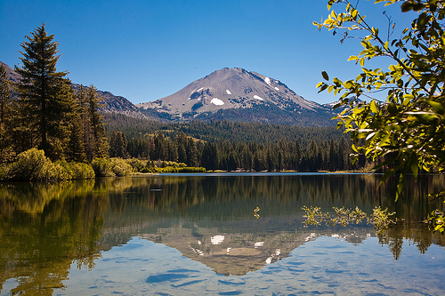
approximately 200 kilometers from Sacramento. A special feature of
the park is its volcanic landscape around Lassen Peak, which was
last active between 1914 and 1921 and is the southernmost volcano in
the Cascade chain. The 431 km² area was placed under protection in
1916 - in the wake of increased public interest after the eruption
of Lassen Peak - and has since been managed by the National Park
Service.
In the area around Lassen Peak, the earth is still
volcanically active, as evidenced by mud pots, hot springs, and
fumaroles (see geothermal areas in Lassen Volcanic National Park).
Lassen is one of the few areas in the world where four types of
volcanoes occur simultaneously: shield volcanoes, cinder cones, lava
domes, and stratovolcanoes.
Today, Lassen Volcanic National
Park's remote location is one of the lesser-known and less-visited
national parks in the United States. Of the approximately 150 miles
of hiking trails in the park, the trails along California State
Route 89 to the top of Lassen Peak and the Bumpass Hell hydrothermal
vents are the primary use. Since 2008, the Kohm Yah-mah-nee Visitor
Center has been a new visitor center at the south-west entrance to
the park. Peak season typically spans June through September, as
State Route 89, which runs through the park, is closed for snow
during the remaining months.
Park entrance fees are $10 for private vehicles
and $5 for individuals on foot, bike and motorcycle. All entrance
fees are valid for seven days. The Annual Pass is available for $25,
allowing park entry for one year.
There are several passes
for groups traveling together in a private vehicle or individuals on
foot or on bike. These passes provide free entry at national parks
and national wildlife refuges, and also cover standard amenity fees
at national forests and grasslands, and at lands managed by the
Bureau of Land Management and Bureau of Reclamation. These passes
are valid at all national parks including Lassen Volcanic National
Park:
The $80 Annual Pass (valid for twelve months from date
of issue) can be purchased by anyone. Military personnel can obtain
a free annual pass in person at a federal recreation site by showing
a Common Access Card (CAC) or Military ID.
U.S. citizens or
permanent residents age 62 or over can obtain a Senior Pass (valid
for the life of the holder) in person at a federal recreation site
for $80, or through the mail for $90; applicants must provide
documentation of citizenship and age. This pass also provides a
fifty percent discount on some park amenities. Seniors can also
obtain a $20 annual pass.
U.S. citizens or permanent residents
with permanent disabilities can obtain an Access Pass (valid for the
life of the holder) in person at a federal recreation site at no
charge, or through the mail for $10; applicants must provide
documentation of citizenship and permanent disability. This pass
also provides a fifty percent discount on some park amenities.
Individuals who have volunteered 250 or more hours with federal
agencies that participate in the Interagency Pass Program can
receive a free Volunteer Pass.
4th graders can receive an Annual
4th Grade Pass that allows free entry for the duration of the 4th
grade school year (September-August) to the bearer and any
accompanying passengers in a private non-commercial vehicle.
Registration at the Every Kid in a Park website is required.
In
2018 the National Park Service will offer four days on which entry
is free for all national parks: January 15 (Martin Luther King Jr.
Day), April 21 (1st Day of NPS Week), September 22 (National Public
Lands Day), and November 11 (Veterans Day weekend).
The name of the national park is derived from the Danish-born immigrant Peter Lassen (1800-1859), who is said to have climbed Lassen Peak (sometimes also: "Mount Lassen") as the first European. Lassen, a blacksmith by trade, emigrated to the United States in 1830, moved to California ten years later, and in 1844 acquired a large tract of land in what is now Tehama County. After the start of the California Gold Rush, Lassen developed this upper part of the California Longitudinal Valley by exploring a new wagon route across the mountains. Various places in Northern California are named because Lassen was the first European to settle permanently in this part of California. In addition to Lassen Peak and the national park, Lassen National Forest is also named after him. Whether the first ascent of Lassen Peak, which is attributed to Lassen, actually took place, can no longer be clarified today. The only thing that is certain is that the volcano, previously known as "San Jose", "Mount Joseph", or "Mount Saint Joseph" received its current name from the gold prospector Grover K. Godfrey after an encounter with Peter Lassen in 1851. The first documented ascent of Lassen Peak was made by Godfrey himself.
Lassen Volcanic National Park is located at the southern end of the
Cascade Range, a volcanic mountain range that runs parallel to the west
coast of North America and is part of the Pacific Ring of Fire. The
sanctuary covers an area of more than 430 square kilometers and is
located east of the upper Sacramento Valley, a heavily agricultural
region of Northern California.
The park's two entrances are
connected by California State Route 89, which loops through Lassen
Volcanic National Park around Lassen Peak. From the Redding interchange
off Interstate 5, the northwest entrance to the park can be reached via
California State Route 44. From the town of Red Bluff, also on
Interstate 5, California State Route 36 leads to the southwest entrance.
From the college town of Chico, the same park entrance can be reached
via California State Route 32 and then California State Route 36.
Visitors from Reno, Nevada (which can fly into Reno-Tahoe Airport) can
access the northwest park entrance via California State Route 44 or the
southwest entrance via California State Route 36 through the small town
of Chester on Lake Almanor.
The national park administration
divides the protected area into five different regions:
Manzanita &
Summit Lakes in the northwest portion of the park offers a variety of
visitor facilities including the Loomis Museum, as well as the park's
largest campground on the edge of Manzanita Lake, which also has a
convenience store attached. Hikers reach the beginning of a trail to
Summit Lake 20 kilometers south of Manzanita Lake.
Southwest at the
southwestern entrance to the park are the park's most famous
hydrothermal attractions, Sulfur Works and Bumpass Hell. At the Kohm
Yah-mah-nee Visitor Center, exhibits and a short film provide
information for tourists. From a parking lot at the base of Lassen Peak,
the volcano can be climbed via the Lassen Peak Trail.
Warner Valley
to the south offers other hydrothermal areas such as Devils Kitchen,
Boiling Springs Lake and Terminal Geyser near the historic Drakesbad
Guest Ranch.
Juniper Lake in the remote southeast is dominated by the
largest lake in the park.
Butte Lake, known for the Fantastic Lava
Beds block lava fields, the Painted Dunes and the Cinder Cone cinder
cone. Part of the Nobles Emigrant Trail, used by early settlers, runs
along the edge of the Fantastic Lava Beds.
Until the arrival of the white settlers
Before the arrival of
white settlers, the Lassen Peak area was inhabited by the Yahi, Yana,
Atsugewi and Maidu tribes. Due to the harsh winters, they only came to
the area of today's national park in the summer months to hunt and fish
and to collect berries and nuts.
The region played only a minor
role in the settlement of California by European immigrants. The covered
wagon route first used by Peter Lassen in 1848 through what is now the
national park turned out to be too difficult and never gained the
importance of the Donner Pass and Carson Pass mountain passes further
south in the Sierra Nevada. A route developed by William H. Nobles in
the 1850s, while used by a greater number of settlers than the Lassen
Trail, also played a minor role compared to the Sierra Nevada passes and
was eventually abandoned.
First explorations
As the Sacramento
Valley was settled, interest in the Southern Cascade Range also
increased. In 1863, the California Geological Survey sent an expedition
led by William H. Brewer to what is now the national park area, which
provided the first results in understanding the area's volcanic origins.
In August 1863, painter Helen Brodt became the first non-Indigenous
woman to scale Lassen Peak. Lake Helen, located at the foot of the
volcano, was later named after her.
In 1873, naturalist Harvey W.
Harkness was the first to climb Cinder Cone. From 1883, the geologist
Joseph S. Diller explored the area of today's national park on behalf of
the United States Geological Survey. His forty years of work resulted in
numerous papers and in the statement that Lassen Peak belongs to the
Southern Cascade Range and not to the Sierra Nevada.
The
establishment of the national park
When loggers, ranchers and
railroad companies began to pose an increasing threat to the area of
today's national park at the beginning of the 20th century, the American
President and early advocate of nature conservation Theodore Roosevelt
ordered the establishment of the two national monuments Cinder Cone
National Monument and Lassen in May 1907 Peak National Monument.
Just seven years later, on May 30, 1914, Lassen Peak erupted. The event
was followed with great interest by the public, bringing journalists,
photographers, scientists and onlookers to the sanctuary. After a series
of smaller eruptions, there was an eruption in May 1915 that was so
strong that volcanic ash reached the city of Reno, about 240 kilometers
to the southeast.
The volcanic eruptions generated such great
public interest that on August 9, 1916, President Woodrow Wilson
designated 79,561 acres (about 32,197 hectares) as a national park. Just
two weeks later, Wilson signed legislation establishing the National
Park Service, which has been responsible for the administration and
protection of national parks in the United States ever since.
Damage from the Dixie Fire
The national park was hit hard by the
Dixie Fire in California's 2021 wildfire season. As of September 11,
72,347 acres (292 km²) of the national park were affected by fire, more
than two-thirds of the total area of 106,452 acres (430.8 km²). On
August 7, Park Superintendent Jim Richardson announced that the fire
lookout tower on Mount Harkness, listed on the National Register of
Historic Places, was destroyed in the fire. The observation deck at
Kings Creek Falls and the campground at Juniper Lake were also
destroyed. The Drakesbad Guest Ranch in the Warner Valley, which is
popular with day trippers and hikers alike on the Pacific Crest Trail,
was saved – with the exception of two of the five cabins for overnight
guests.
With elevations ranging from 1500 meters (5000 feet) to 3000 meters (10,000 feet), the park includes three vegetation zones. Below approximately 2,000 meters (6,500 feet) elevation, mixed conifer forest is dominated by ponderosa (Pinus ponderosa) and Jeffrey pine (Pinus jeffreyi), sugar pine (Pinus lambertiana), and silver fir (Abies alba). Among the shrubs in this vegetation zone, the evergreen shrubs of the genus Arctostaphylos, known in English as “manzanita”, prevail, as well as currant shrubs (Ribes) and shrubs of the genus Ceanothus. Common wildflowers include those of the Iris genus, Corallorhiza maculata of the Coralroot genus, plants of the Wintergreen genus (Pyrola), violets (Viola), and lupins (Lupinus). Between an elevation of around 2000 meters (6500 ft) and 2500 meters (8000 ft), spruce (Picea abies), digger pine (Pinus sabiniana), hemlock (Tsuga) and coastal pine (Pinus contorta) dominate a plant community that is less diverse than the mixed coniferous forest at lower altitudes. This vegetation zone is also home to the species Lupinus obtusilobus, Wyethia mollis and Arctostaphylos nevadensis commonly found in the mountains of Northern California. In the adjoining subalpine vegetation zone, whitebark pine (Pinus albicaulis) and mountain hemlock (Tsuga mertensiana) are the dominant trees. Below the tree line, the number of plants is generally lower, with undemanding plants from the genera Petrophytum, Castilleja (engl. "Indian Paintbrush"), Penstemon, and lupins being found in this harsh environment.
Visitors: numbers, typical activities and facilities
Among the
nine national parks in California, Lassen Volcanic National Park is one
of those with a comparatively small number of visitors. Between 2011 and
2021, its average annual visitor count was only about one-eighth that of
Yosemite National Park, with the latter receiving by far the most
visitors of any national park in California.
According to Mike
White, author of a popular hiking guide to the park, the vast majority
of annual visitors focus on the attractions along California State Route
89, which loops through the park. Only 10-15% of annual visitors stay
overnight at one of the five campgrounds near California State Route 89,
and again only 15% of those migrate to the park's more remote areas.
Although there are approximately 150 miles (241 km) of designated hiking
trails in the park, most visitors use only two trails: the trail up
Lassen Peak and the trail to Bumpass Hell, one of the park's main
attractions with its hydrothermal vents.
The Kohm Yah-mah-nee
Visitor Center, which is open all year round and is located in the
southwest of the park, serves to orient visitors. This visitor center
has an exhibition hall with cinematic introductions, an amphitheater, a
gift shop, a small café and a viewing terrace. Not far from the
northwest park entrance is the Loomis Museum, built in 1927 by Benjamin
Loomis, one of the park's early patrons. Located near Manzanita Lake,
the museum is open only during the summer months and has been on the
National Register of Historic Places since 1975.
Tourist offers
in the winter and summer season
California State Route 89 is closed
between the two southwest and northwest park entrances between November
and May, and in harsher winters also between late October and mid-July.
In the Southwest, where snow falls above 6700 feet (2042 meters),
visitors can leave their cars in the Kohm Yah-mah-nee Visitor Center
parking lot and walk to the Sulfur Works Hot Springs. There is also a
winter camping area south of the visitor center parking lot. To the
northwest, the Manzanita Lake area can be reached by car. Winter visitor
activities include hiking, skiing, snowboarding, sledding, and
ranger-led snowshoe tours. Cleared portions of State Route 89 are open
to bicycles even in winter.
In summer and fall, in addition to
the numerous hiking trails in more remote parts of the park, the
attractions along State Route 89 are particularly available to visitors.
In addition to the five campgrounds located along the State Route, there
are three more at Butte Lake, Juniper Lake and Warner Valley. Overnight
log cabins are available on the grounds of Drakesbad Guest Ranch in
Warner Valley and on the edge of Manzanita Lake. Typical visitor
activities during the summer season include hiking, guided tours by park
rangers, swimming, boating, fishing, picnicking, and biking, among
others. Overnight stays in the wilderness require a backcountry permit
detailing an emergency contact and where to stay overnight. Bear
canisters are required for transporting food supplies when hiking in
remote areas of the park. From January 2023, backcountry permits can be
purchased online for a small fee.