Location: Adamana, AZ Map
Area: 93,533 acres (37,851 ha)
Official site
Tel. (928) 524- 6228
Open: 8am- 5pm daily
Closed: Dec 25th
Rainbow Forest Museum
Tel. (928) 524- 6822
Open: 8am- 5pm daily
Petrified Forest National Park is a U.S. national park located in
Navajo and Apache counties in northeastern Arizona. It is a
semi-desert area of shrub steppe and highly eroded, colorful
badlands. The park headquarters is located along Interstate 40
(I-40) about 26 miles (42 km) east of Holbrook, where the BNSF
Railway's Southern Transit, the Puerco River, and historic U.S.
Route 66 cross the park nearly east-west. Stretching north into the
Painted Desert, the site was designated a National Monument in 1906
and a National Park in 1962; in 2018, the park had 644,922
recreational visitors.
With an average elevation of
approximately 5,400 feet (1,600 m), the park has a dry, breezy
climate with temperatures varying from a summer high of about 100°F
(38°C) to a winter low of below freezing. The park is home to more
than 400 plant species, primarily grasses such as bunchgrass, blue
grama, and sakaton. Animal life includes large animals such as
pronghorn, coyote, and bobcat; small animals such as deer mice;
snakes, lizards, and seven species of amphibians; and over 200
species of birds, some resident and many migratory. About one-third
of the park is designated as old-growth forest, 50,260 acres (79
square kilometers; 203 km2).
The Petrified Forest is known
for its fossils of fallen trees from the Late Triassic period, 225
million years ago. The fossil-bearing deposits are part of the
extensive and colorful Chinle Formation, which gave the Painted
Desert its name. Beginning about 60 million years ago, the Colorado
Plateau, where the park is located, was pushed up and eroded by
tectonic activity. All rock formations above the Chinle, except for
the geologically newer ones found in parts of the park, have been
scoured by wind and water. Fossils found in the park include
petrified logs, many plants such as ferns, cycads, and ginkgo from
the late Triassic period, and animals such as giant reptiles called
phytosaurs, large amphibians, and early dinosaurs Since the early
20th century, paleontologists have been excavating and studying
fossils in the park.
The earliest human presence in the park
was 13,000 years ago. These Clovis-era people are believed to be the
ancestors of Native Americans. About 2,500 years ago, Pueblo farmers
grew corn and lived in pit dwellings underground in what would
become the park; 1,000 years ago, Pueblo farmers lived in
above-ground stone dwellings called pueblos and gathered in large
communal buildings called great kivas; and by 1450, the Pueblo
people were living in a large, open-air pueblo called the Great
Kiva, which was built on the site of the park. AD By 1450, the
ancestral Pueblo farmers of the Petrified Forest had migrated to the
rapidly developing communities of Hopi Mesa to the northwest and the
Zuni pueblo to the east. More than 1,000 archaeological sites,
including petroglyphs, have been discovered in the park. These
ancestral sites continue to be important to the communities of their
descendants: in the 16th century, Spanish explorers visited the
area, and in the mid-19th century, an American team surveyed an
east-west route through the area where the park now stands and noted
petrified trees. Later, before roads and railroads were built,
tourism increased, and the park was protected, fossils were removed
from the area on a large scale; even in the 21st century, theft of
petrified wood is still a problem, and the park's petrified trees
have been found in the area for centuries.
Colonization
Rock carvings, finds of shards and the remains of
settlements indicate human settlement around 2,000 years ago. There is
currently no precise information about this, but it is certain that
there were several settlement phases. This ranges from early nomadic
tribes to the Pueblo culture around 1100 to 1400. From the period after
1400 there is no longer any evidence of human settlement.
In the
mid-19th century, surveyors from the Army Corps of Topographical
Engineers came to this area. With their reports, they brought tales of a
"painted desert" and trees turned to stone back to the East. They were
followed by the first settlers and ranchers.
Commercial use
The bright colors and patterns of the various mineral deposits, which
come into their own after grinding and polishing, make petrified wood an
ideal material for decorative arts. For some time the petrified wood was
mined, mainly for the souvenir business. When it was realized that these
deposits were only limited, the first voices came to preserve some of
the particularly rich deposits. Today's park now protects them and thus
preserves future generations an insight into human history and the
geological development of the earth.
Pieces of jewelry (e.g.
pendants), animal figures and various decorative objects, but also
unprocessed or just polished pieces are available in stores. There are
also larger find sites outside of the park, and these are the only
places where the material comes from. No part, no matter how small, may
be taken out of the park itself. Violations of this prohibition are
subject to draconian penalties. When leaving the park you have to expect
car checks. Walking off the path is also strictly prohibited.
The Painted Desert is located in the northern part of the park, above
Interstate 40 between Holbrook and Navajo. This is an arid wasteland
where erosion has sculpted a colorful landscape.
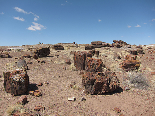
Most of the
petrified wood can be seen in the southern part of the national park,
where you can also find old rock carvings, so-called petroglyphs. The
best known are attached to the "Newspaper Rock". Also nearby are the
ruins of an 11th-century pueblo, the Puerco Pueblo.
Painted Desert - from the northern park entrance, the road runs along
the edge of the "Painted Desert". Some vantage points offer a beautiful
view over the highlands.
The Tepees – Rock formations reminiscent of
Plains Indian teepees because of their cone shape. The individual rock
layers of the Blue Mesa Member can be seen very well on them.
Blue
Mesa - an approximately 5 km long road winds through the hilly
landscape, there is also a small loop trail. The Blue Mesa Member clay
layers visible here, ranging from white to blue-grey in color, gave this
part of the landscape its name.
Crystal Forest – there is also a
small loop trail here, about half a kilometer long. Along the circular
route there are trunks with a thickness of almost a meter in some cases.
What is special about the trunks are clear quartz and amethyst crystals
that have formed in cavities.
The dry desert area on the edge of the Colorado Plateau is
particularly impressive because of the many colors that this landscape
shows. These are particularly striking in the "painted desert" and the
"tepees". The layers of rock on top of each other appear as if drawn
with a ruler:
its base consists of rock partly colored reddish by
iron oxide,
the white layer above consists of sandstone,
a strong
red colored layer of iron-interspersed sedimentary rock (silt) follows,
Finally, the dome is made of dark clay that got its color from the
addition of organic carbon.
Within the park, the progress of erosion
can be observed well. While the top layer of clay on the "Tepees" has
almost been removed, in the higher lying area of the "Blue Mesa" only
this is visible so far.
The rock strata in the area of the national park belong to the Upper
Triassic Chinle Formation, which essentially consists of fluviatile and
lacustrine deposits. They are generally flat and only slightly dip to
the south. In the park, the following layers are unlocked (from young to
old):
Owl Rock Member
Upper Petrified Forest Member
Sonsela
Sandstone Member
Blue Mesa Member
At the northern edge of the
park, the Chinle Formation is unconformably overlain by the Late
Miocene-Early Pliocene volcanogenic Bidahochi Formation. Above this are
Late Pleistocene and Holocene dunes and alluvial deposits.
The approximately 225 to 220 million year old Blue Mesa Member
consists mainly of variegated (grey, blue, purple and green) mudstones
with only a few sandstone beds such as the Newspaper Rock Sandstone. It
is best exposed near the «Tepees».
The approximately 216 million
year old Sonsela Sandstone member, often just a Sonsela member, can be
divided into three parts:
Flattops-One-Bed, a thick, resistant,
diagonally beaded sandstone unit.
Jim Camp Wash Beds, blue, gray and
purple mudstones alternating with numerous layers of gray and white
sandstone.
Rainbow Forest Bed, white sloping sandstones and
conglomerates of rounded pebbles and boulders. In this location there
are silicified tree trunks. It forms the final overburden at Blue Mesa,
Agate Mesa and north of Rainbow Forest.
The Upper Petrified
Forest Member, often just Petrified Forest Member, leads to red colored
mudstones and brown sandstones. It is well exposed in the flattops and
contains countless fossilized tree trunks. In the Painted Desert it is
formed as a white and pink unit containing reworked volcanic sediments.
The switched-on Black Forest bed has been radiometrically dated at 213 ±
1.7 million years.
Approximately 205 million years old, the Owl
Rock member consists of pink to orange claystones alternating with hard
thin layers of limestone. It also contains gypsum lenses (selenite) that
formed when former lakes evaporated. The Owl-Rock Member queues at
Chinde Mesa on the north edge of the park.
The approximately 16
to 4 million year old Bidahochi Formation unconformably follows the Owl
Rock member of the Chinle Formation with a 184 million year
stratigraphic gap. In its lower section it carries fine-grained
fluviatile and lacustric sediments (silts, clays and sands) - at that
time northeastern Arizona was covered by an extensive network of
ephemeral lakes. Above that follow volcanics: phreatomagmatic ash and
lava flows. The origin of these volcanic inputs is mostly local in
nature, but can sometimes be traced to southwestern Nevada (Southwest
Nevada Volcanic Field). Subsequent erosion has now eroded a large part
of the Bidahochi Formation, leaving some cinder cones and maars.
However, in areas of erosion-resistant lava flows (e.g. Pilot Rock and
Hopi Buttes), the underlying lake sediments have been conserved. The
adjoining Hopi Buttes Volcanic Field to the northwest has one of the
largest accumulations of maars in the world.
Aeolian and alluvial
deposits overlaid the volcanic rocks in the late Pleistocene. The oldest
dune fields are around 500,000 years old, they are in the higher parts
of the national park and show a northeast-southwest orientation. In
younger river courses such as the sandy Lithodendron Wash, a younger
dune generation occurs that is only about 10,000 years old. Recent up to
a maximum of 1,000 years old dunes can actually be observed everywhere;
they are usually stabilized by grass growth. The remains of an original
proboscidea have even been discovered in these Quaternary sediments.
The erosion is still progressing now, so the Little Colorado River
and its tributary, the Puerco River, are constantly deepening their
canyons in the relatively soft Chinle Formation and the associated
"washes" then clear these sediments more and more together with the
overlying Bidahochi Formation out of.
About 215 million years ago, in the Late Triassic period, there was
an alluvial plain here with many rivers running through it. Araucarias,
tree ferns and conifers formed the vegetation. Crocodile-like reptiles,
giant amphibians, and smaller dinosaurs lived in this country. Evidence
of this is provided by many fossil finds in the Chinle Formation.
Floods buried fallen trees under mud and silt. Burying more deposits
slowed down the natural decay of the wood due to the lack of oxygen.
Under the thickening sediment cover, siliceous groundwater seeped into
the tree trunks. Quartz and chalcedony were deposited in the cavities of
the trunks, gradually replacing the cell tissue and thus obtaining the
wooden structures of the trunks in stone.
The strata continued to
sink and were flooded again. More and more layers of water-borne
material were deposited on top. Tectonic movements in the earth's crust
that began much later (see Laramie orogeny) lifted the land surface, and
the resulting stresses within the rock layers caused the trunks to
break. The now intensified erosion by wind and water gradually eroded
the softer layers of the sediments and thus exposed the petrified tree
trunks, which consist of hard quartz substance.