Location: Nye County, NV Map
Founded: 1904
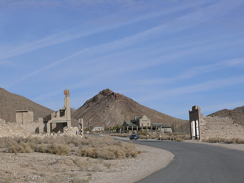
Rhyolite, Nevada, is one of the most iconic and photogenic ghost towns in the American West, located in Nye County, approximately 120 miles northwest of Las Vegas and 4 miles west of Beatty, near the eastern boundary of Death Valley National Park. Situated in the Bullfrog Hills at an elevation of 3,800 feet, Rhyolite was a bustling gold-mining boomtown from 1905 to 1910, with a peak population estimated at 3,500 to 5,000. Today, managed by the Bureau of Land Management (BLM) as the Rhyolite Historic Area and listed on the National Register of Historic Places, it is renowned for its well-preserved ruins, including the Cook Bank Building, the Tom Kelly Bottle House, and the Las Vegas & Tonopah Railroad Depot. The nearby Goldwell Open Air Museum, with its surreal sculptures, adds an artistic dimension to the site. Rhyolite’s dramatic boom-and-bust cycle, coupled with its stark desert setting, makes it a compelling destination for historians, photographers, and adventurers, drawing thousands annually to explore its crumbling structures and haunting legacy.
Before European-American settlement, the Bullfrog Hills were part of the territory of the Western Shoshone and Southern Paiute peoples, who lived nomadically, hunting, gathering, and utilizing springs in the Amargosa Valley. The region’s harsh desert environment limited permanent settlements, but archaeological evidence suggests seasonal camps near water sources like the Amargosa River, named “amargo” (Spanish for “bitter”) due to its high salt content. The 1848 California Gold Rush and subsequent Nevada strikes in the 1850s brought prospectors, disrupting Native lifeways through land encroachment and violence, though specific impacts on the Bullfrog area are less documented.
Rhyolite’s story begins on August 9, 1904, when
prospectors Frank “Shorty” Harris and Ernest “Ed” Cross discovered
gold-bearing quartz in the Bullfrog Hills, naming their claim the
“Bullfrog” for its green, turquoise-like rock speckled with yellow
metal, resembling a frog’s back. Assayed at $665 per ton in nearby
Goldfield (equivalent to $22,000 today), the find sparked the Bullfrog
Mining District gold rush, one of Nevada’s last great mining booms.
Harris, a colorful figure known from Death Valley, proclaimed, “The
district is going to be the banner camp of Nevada!”
By late 1904,
hundreds of prospectors flooded the area, staking over 2,000 claims
within a 30-mile radius. Temporary camps like Bullfrog, Amargosa, and
Jumpertown sprang up, but Rhyolite, platted in January 1905 in a
sheltered basin near the Montgomery Shoshone Mine, emerged as the
district’s hub. Named for the region’s silica-rich volcanic rock
(rhyolite, a felsic igneous rock akin to granite), the town grew
rapidly, fueled by Goldfield’s and Tonopah’s established supply
networks, 60 and 90 miles north, respectively.
Rhyolite’s growth was explosive. By May 1905, it had
1,500 residents, concrete buildings, and a post office in a 10x12-foot
tent on Golden Street, with Anna B. as the first postmaster. Four
stagecoach lines and the Tonopah and Goldfield Auto Company connected
Rhyolite to the region, while three railroads—Las Vegas & Tonopah
(1906), Bullfrog-Goldfield (1907), and Tonopah & Tidewater (via Gold
Center, 1907)—arrived by 1906–1908, hauling ore and passengers.
Industrialist Charles M. Schwab, a steel magnate, purchased the
Montgomery Shoshone Mine in 1906 for $2–6 million, investing heavily in
infrastructure: piped water from springs 23 miles away, electric lines
from the Nevada-California Power Company, and a $250,000 mill with
cyanide tanks. By 1907, Rhyolite boasted modern amenities rare for a
desert town:
Infrastructure: Electric streetlights (400 total),
water mains, concrete sidewalks, telephones, and telegraph lines.
Institutions: Three banks, three newspapers (Rhyolite Herald, Bullfrog
Miner, Rhyolite Daily Bulletin), a stock exchange, a board of trade, a
hospital, a school (200+ students), police and fire departments, and an
opera house hosting performances.
Businesses: 53 saloons, 35 gambling
halls, a red-light district, two undertakers, three swimming pools, and
stores like the H.D. & L.D. Porter Brothers’ mercantile, which sold
mining supplies and food.
Buildings: Notable structures included the
three-story John S. Cook Bank ($90,000, with marble stairs and
stained-glass windows), the Overbury Building, and the Southern Hotel.
The Tom Kelly Bottle House, built in 1905–1906 by Australian miner Tom
Kelly, used 50,000 glass bottles (mostly beer and liquor) cemented with
adobe, a creative response to scarce timber. The Montgomery Shoshone
Mine, the district’s largest, produced $1 million in ore by 1908 (about
$27 million today). Population estimates vary, with scholarly sources
citing 3,500–5,000 at its 1907–1908 peak, though some claim up to
10,000.
Rhyolite’s prosperity was short-lived, undone by
economic and geological realities:
Financial Panic of 1907: A
nationwide banking crisis tightened capital markets, halting mine
investments. Speculative stock schemes, common in Rhyolite, collapsed,
undermining confidence.
1906 San Francisco Earthquake: Disrupted rail
service and stock markets, impacting mineral prices.
Geological
Limits: The Bullfrog Hills’ high-grade gold veins were narrow and
pinched out at depth. By 1909, the Montgomery Shoshone Mine operated at
a loss, closing in 1911. Low-grade ore was unprofitable with early
20th-century technology.
A 1908 fire destroyed the red-light district
and parts of the business district, accelerating decline. By 1910, the
population plummeted to 675, and all three banks closed. The last
newspaper ceased in 1912, the post office in 1913, and the final train
left in 1914. In 1916, the power company dismantled its lines, leaving
Rhyolite dark. The 1920 Census recorded only 14 residents, and by 1924,
the last holdout, a 92-year-old man, died.
Buildings were
scavenged for materials. The Miners’ Union Hall became Beatty’s Old Town
Hall, cabins were reassembled as homes, and school parts built a Beatty
school. By the 1920s, Rhyolite was a ghost town, its concrete ruins
resisting the desert’s harsh winds.
Rhyolite’s ruins drew attention as early as 1925, when
Paramount Pictures restored the Bottle House for the film The Air Mail.
In 1936, N.C. Westmoreland converted the Las Vegas & Tonopah Depot into
a casino and museum, later maintained by his sister H.H. Heisler as a
curio shop until the 1970s. Hollywood used Rhyolite as a backdrop, with
the Cook Bank as a Mexican ruin in films, though some shoots caused
damage.
In 1947, Rhyolite was offered for sale, signaling its
status as a historical curiosity. The BLM took over management in the
1970s, stabilizing key structures like the Cook Bank, Bottle House, and
depot. A 2022 historical marker was added to the Cook Bank, and the site
joined the National Register of Historic Places. The Goldwell Open Air
Museum, founded in 1984 by Belgian artist Albert Szukalski, added
sculptures like The Last Supper and Tribute to Shorty Harris, enhancing
Rhyolite’s allure.
Recent open-pit mining near Rhyolite,
particularly in the 1980s, raised concerns about the site’s integrity,
but BLM oversight ensures public access. Threats from utility-scale
solar projects in the Amargosa Valley persist, potentially altering the
desert vista.
Rhyolite sits in the Bullfrog Hills, part of the
southwestern Nevada volcanic field, at the northern end of the Amargosa
Desert. Bordered by ridges on three sides but open to the south, it lies
4 miles east of Beatty and the Amargosa River, 5 miles east of the
Funeral and Grapevine Mountains, and 25 miles west of Yucca Mountain.
The town’s 3,800-foot elevation mitigates Death Valley’s extreme heat,
though summer highs reach 97°F, and winter lows dip to 27°F. High winds
and aridity define the climate, with sparse vegetation like Joshua trees
and greasewood in nearby Sarcobatus Flat.
Geologically, the
Bullfrog Hills feature rhyolitic lava flows, 13.3 to 7.6 million years
old, overlying Paleozoic sedimentary rocks. These flows, up to 8,000
feet thick, host gold in near-vertical fault zones, fractured by
tectonic stresses. The green, gold-flecked “bullfrog rock” inspired the
district’s name, with ore values rivaling major strikes like Goldfield.
Rhyolite’s ruins, managed by the BLM, are among
Nevada’s best-preserved, with concrete and stone structures enduring the
desert’s harsh conditions. Key remnants include:
Cook Bank
Building: A three-story ruin, built in 1907 for $90,000, with marble
stairs and stained-glass windows, now a skeletal frame and the West’s
most photographed ghost town relic.
Tom Kelly Bottle House: Restored
in 1925 and 2005, this 1905 structure of 50,000 bottles is Nevada’s
best-preserved bottle house.
Las Vegas & Tonopah Depot: A 1908
Spanish-style station ($130,000), later a casino and museum, now closed
but intact.
Porter Brothers Store: Built in 1906, with large glass
windows, closed in 1910; H.D. Porter served as postmaster until 1919.
Schoolhouse: The 1909 second school ($20,000), partially standing,
served 200+ children at its peak.
Other Ruins: The Overbury Building,
jail (originally the mercantile, burned in 2014), and mine entrances dot
the site.
The Goldwell Open Air Museum, just south, features
Szukalski’s The Last Supper (1984), a ghostly plaster rendition of da
Vinci’s fresco, alongside works like Lady Desert: The Venus of Nevada
(cinder blocks) and Tribute to Shorty Harris (with a penguin,
symbolizing alienation). The museum, free but donation-based, includes a
small Rhyolite history exhibit.
Preservation efforts focus on
stabilizing ruins, with fencing to deter vandalism. The 2014 lightning
strike that destroyed the mercantile underscores ongoing risks. The
BLM’s day-use policy (sunrise to sunset) ensures access, with no
facilities except a latrine-style toilet.
Rhyolite is a photographer’s paradise, its ruins
framed by the Amargosa Valley and distant Telescope Peak. A 1–2-hour
visit covers the main street, where interpretive signs detail the Cook
Bank, depot, and Bottle House. Visitors can walk among ruins but must
avoid entering fenced areas or taking artifacts. The Goldwell Museum’s
sculptures, a 5-minute walk south, add a surreal contrast, with The Last
Supper particularly striking at sunset.
The site’s eerie quiet,
punctuated by desert winds, evokes its boomtown past. Paranormal
enthusiasts report “ghosts,” with Ghost Adventures featuring Rhyolite,
though no verified supernatural evidence exists. The nearby cemetery,
red-light district ruins, and mine entrances offer further exploration,
but caution is advised due to unstable ground.
No services are
available; visitors must bring water, hats, and sunscreen, especially in
summer’s 97°F heat. Beatty, 4 miles east, offers gas, food (e.g., Death
Valley Nut and Candy Company), and lodging. The site’s proximity to
Death Valley’s east entrance (20 miles) makes it a popular stop en route
to Stovepipe Wells or Furnace Creek.
Rhyolite epitomizes the boom-and-bust cycle of Western
mining towns, its rapid rise and fall driven by gold fever and economic
volatility. Its modern infrastructure—electricity, railroads, and
concrete buildings—set it apart from canvas-and-wood camps, reflecting
early 20th-century ambition. The Montgomery Shoshone Mine’s $1 million
output underscores its economic impact, while Schwab’s investment
highlights industrialist influence.
The town’s diversity included
miners, speculators, and service providers, though records of Native,
Chinese, or Black residents are sparse, likely due to Nevada’s
exclusionary policies. The Shoshone are noted in 1908 photos at the post
office, suggesting some presence. Rhyolite’s cultural legacy includes
its role in films and art, with the Goldwell Museum bridging past and
present. Its preservation by the BLM and community efforts in Beatty,
like the Exchange Club’s 1906 restoration, ensure its story endures.
Access: From Las Vegas (120 miles, 2 hours), take U.S.
95 north to Beatty, then NV-374 west 4 miles; turn right onto Rhyolite
Road (paved, 1.8 miles). From Death Valley’s Stovepipe Wells (30 miles),
take CA-190 east to Daylight Pass Road, then left to Rhyolite.
Timing: Visit in spring (March–May) or fall (September–November) to
avoid 97°F summer heat or 27°F winter lows. Allow 1–2 hours for Rhyolite
and Goldwell. Sunrise or sunset enhances photography.
Preparation:
Bring water, sunscreen, hats, and sturdy shoes. No services exist; stock
up in Beatty. Cell service is spotty; download maps offline.
Safety:
Stay on paths to avoid unstable ruins or mine shafts. Summer heat risks
dehydration; winter requires layers. Watch for rattlesnakes. Some
buildings are privately owned; respect signs.
Respect: Do not remove
artifacts or deface ruins. Donations at Goldwell support preservation.
Nearby: Explore Beatty’s Exchange Club or Death Valley Nut and Candy
Company. Death Valley’s Titus Canyon (east entrance) is 10 miles away.
Bullfrog district ghost towns like Gold Center are accessible with 4WD.
Events: Beatty Days (October) features antique car shows and burros,
complementing a Rhyolite visit.