Location: Arizona Map
Area: 91,440 acres
Activities: hiking, camping, horse riding
What to see: Sendero Esperanza Trail
Saguaro National Park, situated close to Tucson, Arizona, safeguards a vibrant expanse of the Sonoran Desert ecosystem, featuring an exceptionally high concentration of the towering saguaro cacti alongside a diverse array of other desert flora and fauna. This biodiversity spans from the arid valley floors of the Tucson Basin to the lush, forested peaks of the Tucson and Rincon Mountains, reaching elevations exceeding 8,000 feet (2,400 meters). Encompassing over 91,000 acres, the park is split into two distinct districts: the Rincon Mountain District (Saguaro East), located about 20 miles (32 kilometers) east of Tucson, and the Tucson Mountain District (Saguaro West), approximately 15 miles (24 kilometers) west of the city center. Both areas boast dense populations of the emblematic saguaro cacti, but they also harbor a rich tapestry of plant and animal life adapted to the desert's challenges, making the park one of North America's most biologically diverse deserts with more than 2,000 plant species and 550 animal species.
Established initially as Saguaro National Monument in 1933 by President Herbert Hoover under the Antiquities Act to preserve the unique saguaro populations, the area was elevated to full national park status in 1994 through congressional action, becoming the 52nd national park in the U.S. At its inception, the monument covered only what is now the Rincon Mountain District, spanning about 15,364 acres (6,218 hectares). In 1961, President John F. Kennedy expanded it by incorporating the Tucson Mountain District, with further additions in 1976, 1994, and even 1,232 acres as recently as 2021, bringing the total to 91,716 acres. The region's human history dates back millennia, with evidence of Hohokam people from AD 200 to 1450 leaving behind petroglyphs, pottery, and rock art visible today, particularly in the Tucson Mountain District. Later, Sobaipuri and Tohono O'odham communities inhabited the area, followed by Spanish explorers in the 1500s, miners in the 1800s (extracting copper, gold, and other minerals until 1942), and homesteaders after the 1862 Homestead Act and the arrival of the railroad in 1880. The Civilian Conservation Corps (CCC) played a key role in the 1930s, constructing infrastructure like the Cactus Forest Loop Drive and picnic areas. Over 450 archaeological sites and 60 historic structures, including lime kilns and the Manning Cabin (built in 1905 and listed on the National Register of Historic Places), highlight the park's cultural heritage.
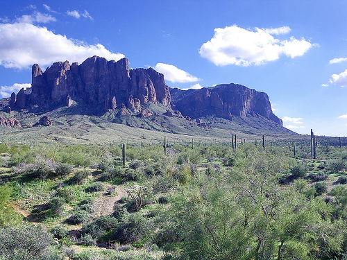
Nestled within the Sonoran Desert—a region characterized by its arid, undulating terrain—the park encompasses the rugged Tucson Mountains to the west and the towering Rincon Mountains to the east, part of the unique "Sky Islands" ecosystem where isolated mountain ranges rise dramatically from the desert floor, creating diverse microclimates. The Tucson Mountain District features volcanic rock formations and elevations from 2,180 to 4,687 feet, while the Rincon Mountain District offers uplifted and eroded metamorphic landscapes ranging from 2,670 to 8,666 feet at Mica Mountain, the highest point. Approximately 71,000 acres are designated wilderness, providing pristine backcountry experiences. Water features are sparse but vital, including the mostly dry Santa Cruz River watershed and Rincon Creek, which flows seasonally and supports the largest riparian zone in the east district, prone to flash floods during monsoons. Smaller springs and tinajas (natural rock basins) dot the landscape, sustaining life in this harsh environment.
The park's signature species, the majestic saguaro cactus, can
endure for up to 200 years, soaring to heights over 50 feet (15
meters) and tipping the scales at more than 10 tons (9,000
kilograms). This desert icon, with its tall, ribbed trunk and
upward-curving arms, thrives through specialized adaptations like
accordion-like pleats in its skin that expand to store water, a waxy
coating to minimize evaporation, and photosynthesis occurring in the
stem rather than leaves. Its shallow root system, extending just
three inches below the surface but spreading as wide as the plant is
tall, efficiently captures scarce rainfall. The park hosts an
estimated 1.8 million saguaros, maturing slowly and not producing
arms until around 75 years old. Other cacti abound, such as the
rotund fishhook barrel cactus, spiny staghorn and teddybear chollas,
Engelmann's prickly pear, and jumping cholla—totaling 24 cactus
species. Shrubs like creosote bush (with its rain-triggered aromatic
compounds), mesquite, palo verde, acacias, and fourwing saltbush
dominate lower elevations, while higher zones in the Rincon District
transition to oak woodlands, pine-oak mixes, ponderosa pine forests,
and mixed conifers including Douglas fir and white fir. A plant
inventory revealed 389 vascular species, 25 non-vascular, and 197
fungi, with bursts of wildflowers like poppies and lupines coloring
the desert after rains.
Wildlife in the park is elusive,
often nocturnal or camouflaged to evade the heat, but observant
visitors may spot a variety of species. Birds number over 107,
including Gambel's quail, greater roadrunners, Gila woodpeckers,
cactus wrens, great horned owls, Harris's hawks, turkey vultures,
hummingbirds, and the threatened Mexican spotted owl. Mammals total
around 30 species, such as javelinas (collared peccaries resembling
wild pigs), coyotes, bobcats, mountain lions, black bears (in higher
elevations), mule and white-tailed deer, gray foxes, ring-tailed
cats, white-nosed coatis, kangaroo rats, desert cottontails, and the
endangered lesser long-nosed bat. Reptiles (36 species) feature
desert tortoises, Gila monsters, diamondback rattlesnakes, coral
snakes, and various lizards like short-horned and zebra-tailed.
Amphibians are rarer, with three species including the canyon tree
frog and the species of special concern, lowland leopard frog, which
relies on seasonal water bodies. Many animals, like the venomous
Gila monster or ectothermic reptiles, adapt by being crepuscular or
burrowing to regulate temperature.
The park experiences a hot semi-arid climate with extreme summer heat often surpassing 105°F (41°C) and annual rainfall averaging less than 12 inches, concentrated in two seasons: winter fronts and summer monsoons that bring intense, short-lived storms, lightning, dust storms, and flash floods. Summer lows hover around 75°F (24°C), while winter highs average 65°F (18°C) with nighttime lows near 40°F (4°C); higher elevations in the Rincon District can see occasional snow. Climate change has driven a roughly 4°F (2°C) rise in mean temperatures since 1900, exacerbating drought and fire risks. Relative humidity stays low at 31–33%, and plant hardiness zones are 9a to 9b, supporting frost-sensitive desert species.
Visitors can explore over 165 miles (266 kilometers) of trails for hiking, with popular options like the Signal Hill Trail for petroglyph viewing in the west or the Arizona Trail segment in the east. Scenic drives include the 5-mile Bajada Loop in the Tucson Mountain District and the 8.3-mile Cactus Forest Loop in the Rincon Mountain District, both paved and suitable for biking or sightseeing. Horseback riding is allowed on select trails, and backcountry camping requires permits in the Rincon District's wilderness areas, such as at Manning Camp. As an Urban Night Sky Place, the park excels in stargazing, with minimal light pollution offering views of the Milky Way. Birdwatching, wildlife viewing, and educational programs at the two visitor centers (Red Hills in the west and Rincon Mountain in the east) enhance experiences. Conservation efforts focus on threats like invasive species (e.g., buffelgrass, which increases fire hazards and outcompetes natives), urban encroachment, pollution, roadkill, and wildfires—managed through monitoring, suppression in low elevations, and controlled burns in higher zones to maintain ecosystem balance. The park also serves as a research hub, studying climate impacts and biodiversity preservation in the Sonoran Desert.
For the latest updates and comprehensive resources, visit the
official Saguaro National Park website at https://www.nps.gov/sagu/.
Rincon Mountain Visitor Center (East District), located at 3693
S Old Spanish Trail, Tucson, AZ 85730, along Cactus Forest Drive.
Contact: ☏ +1 520-733-5153. Open every day from 9 AM to 5 PM between
October 1 and May 31, shifting to 8 AM to 4 PM from June 1 to
September 30; closed on December 25. This center offers essential
park details, maps, and ranger assistance, along with a 15-minute
introductory film on the desert's voices and ecosystem. Visitors can
explore interactive exhibits highlighting the Sonoran Desert's
natural wonders and cultural heritage, including its diverse flora,
fauna, and human history. Additional amenities include a bookstore
and gift shop operated by the Western National Parks Association,
clean restrooms, and vending machines or water stations. It's an
ideal launch point for the scenic 8-mile Cactus Forest Loop Drive,
which provides stunning views of the Rincon Mountains and access to
hiking trails. Accessibility features encompass paved paths with
benches, and the nearby ¼-mile Desert Ecology Trail is fully
ADA-compliant, accommodating wheelchairs with interpretive signs
about local plants and wildlife.
Red Hills Visitor Center (Tucson
Mountain District, West), situated at 2700 N Kinney Rd, Tucson, AZ
85743. Contact: ☏ +1 520-733-5158. Operating daily from 9 AM to 5 PM
from October 1 to May 31, adjusting to 8 AM to 4 PM between June 1
and September 30; closed December 25. Similar to its eastern
counterpart, this facility delivers park guidance, maps, and helpful
rangers, featuring a 15-minute orientation film that delves into
Indigenous perspectives on the land, portraying saguaros as
ancestral figures. The center boasts engaging exhibits on the
Sonoran Desert's geology, biology, and cultural significance,
including touch-friendly interactive displays. Other conveniences
include a well-stocked bookstore and souvenir shop, restrooms, and a
water refill station. From the patio, enjoy panoramic vistas of the
cactus forest, Red Hills, and Tucson Mountains. It serves as the
gateway to the 5-mile Bajada Loop Drive, with roadside pullouts,
picnic spots, and trailheads, plus the adjacent paved 400-yard
Cactus Garden Trail showcasing labeled desert vegetation. For
accessibility, the film program includes volume assistance, audio
descriptions, and neckloop telecoil couplers, with nearby paved
trails equipped with resting benches and exhibits.
By Plane
Tucson International Airport (TUS) is conveniently
situated between the two districts of Saguaro National Park, just
south of the city of Tucson. This major airport is served by several
airlines, including American, Delta, Southwest, and United, offering
flights from various U.S. cities. From the airport, the drive to the
Rincon Mountain District (East) is approximately 16 miles (26 km)
and takes about 30 minutes, while the drive to the Tucson Mountain
District (West) is around 22 miles (35 km) and takes roughly 25
minutes, depending on traffic. Rental cars are available at the
airport, making it easy to reach either district. Note that there
are no direct public transportation options to the park entrances,
so driving or arranging a ride-share/taxi is recommended.
By
Car
Saguaro National Park is divided into two separate districts:
the Rincon Mountain District (East) and the Tucson Mountain District
(West), separated by the city of Tucson. It's advisable to use the
physical addresses for navigation rather than searching for the park
name in map apps, as they can sometimes lead you astray. There is no
RV parking available in either district, and certain routes have
restrictions for larger vehicles.
Saguaro East (Rincon
Mountain District)
From Interstate 10 (westbound toward Tucson):
Exit at Houghton Road (exit 275) and head north for 8 miles. Turn
right onto Escalante Road and continue for 2 miles, then turn left
onto Old Spanish Trail. The park entrance will be on the right after
0.3 miles. Follow posted signs for guidance.
From downtown
Tucson: Head east on Broadway Boulevard to Freeman Road (near the
city's eastern edge). Turn right (south) on Freeman Road for 3
miles, then turn left onto Old Spanish Trail. Drive southeast for
0.25 miles to reach the entrance on the left. Watch for park
signage.
Physical address: 3693 S. Old Spanish Trail, Tucson, AZ
85730.
Saguaro West (Tucson Mountain District)
From
Interstate 10 (eastbound toward Tucson): Take the Avra Valley Road
exit (exit 242) and go west for 6 miles to Sandario Road. Turn left
(south) on Sandario Road for 14 miles, then turn left onto Kinney
Road. The Red Hills Visitor Center is 2 miles ahead on the left.
From downtown Tucson: Drive west on Speedway Boulevard, which
transitions into Gates Pass Road after the junction with Camino de
Oeste. Proceed west on Gates Pass Road to Kinney Road, then turn
right (north) on Kinney Road for 4 miles. At the Kinney and Mile
Wide Roads junction (about 1 mile past the Arizona-Sonora Desert
Museum), turn right into the park and continue north 1 mile on
Kinney Road to the Red Hills Visitor Center on the right. Note: This
route features steep, winding mountain roads with narrow grades, so
vehicles over 25 feet (including trailers and RVs) or weighing more
than 12,000 lbs are not recommended. Instead, use the route from
I-10 via Ina Road (exit 248): head west to Sandario Road, turn left
(south), and follow signs to the park.
Physical address: 2700 N.
Kinney Road, Tucson, AZ 85743.
Entrance fees to Saguaro National Park grant access for a full seven
days, permitting unlimited re-entries during that period and
covering both the Tucson Mountain District (West) and Rincon
Mountain District (East). As of late 2025, the standard fees remain
unchanged from recent years and include:
$15 per individual
entering on foot, bicycle, or horseback (applies to those aged 16
and older; children 15 and under enter free).
$20 per motorcycle,
covering the vehicle and all riders.
$25 per private
non-commercial vehicle, which includes all passengers (such as cars,
trucks, vans, RVs, or campers).
$45 for the Saguaro National Park
Annual Pass, which admits up to four adults (aged 16+) or everyone
in a single non-commercial vehicle for an entire year.
These
fees can be paid at key locations like the Red Hills Visitor Center
in the West District, the Rincon Mountain Visitor Center in the East
District, or the fee kiosk in the Rincon Mountain District. Note
that the park operates on a cashless basis—only credit or debit
cards are accepted, with no cash transactions allowed. For groups or
special circumstances, educational institutions may qualify for a
fee waiver for non-commercial student groups (aged 16+), but this
requires advance application and approval based on specific criteria
related to educational value.
In addition to park-specific
options, the America the Beautiful Pass (also known as the
Interagency Pass) offers broader access, covering entrance fees and
standard day-use amenities at Saguaro National Park, all other
national parks, and thousands of federal recreation sites managed by
agencies like the U.S. Fish and Wildlife Service, U.S. Forest
Service, Bureau of Land Management, Bureau of Reclamation, and U.S.
Army Corps of Engineers. A single pass typically covers an entire
group in a private non-commercial vehicle or up to four individuals
at per-person entry sites. Passes are non-refundable,
non-transferable, and require a valid photo ID for use; they cannot
be replaced if lost or stolen. Several varieties are available to
suit different needs:
The Annual Pass, valid for 12 months
from the purchase date, is open to anyone and costs $80. It's ideal
for frequent visitors to multiple federal sites.
The Senior
Annual Pass, also valid for one year, is priced at $20 and available
to U.S. citizens or permanent residents aged 62 or older (proof of
age and citizenship/residency required). This pass provides a 50%
discount on certain park amenities, such as camping, swimming, boat
launches, and interpretive services, though it excludes special
recreation permits or concession-operated facilities.
The Senior
Lifetime Pass, offering lifelong access for $80, is similarly
restricted to U.S. citizens or permanent residents 62 and above,
with the same 50% amenity discounts. Holders of older Golden Age or
Golden Access Passports can exchange them for this pass at no cost.
The Military Annual Pass is free for current U.S. military members
and their dependents, valid for one year upon presentation of a
Common Access Card (CAC), Military ID, or similar documentation.
The Military Lifetime Pass is free for veterans and Gold Star
Families (relatives of service members killed in action), providing
permanent access with proof of eligibility, such as a veteran health
ID card or official documentation.
The Access Pass, free and
lifelong, is for U.S. citizens or permanent residents with permanent
disabilities; applicants must submit documentation of
citizenship/residency and disability (e.g., a statement from a
licensed physician or federal agency award letter). It includes the
50% discount on select amenities.
The Volunteer Pass is free for
those who have logged 250 or more volunteer hours at participating
federal agencies, offering ongoing access.
The 4th Grade Pass
(also called the Every Kid Outdoors Pass) is free for U.S. fourth
graders and valid from September through August of their school
year; it requires online registration at everykidoutdoors.gov and
covers the child plus accompanying passengers in a private vehicle.
Passes can be obtained in person at over 1,000 federal sites
(recommended for immediate use), online via the USGS store
(store.usgs.gov) with mail delivery (up to three weeks), or
digitally for the Annual Pass only through recreation.gov for
instant mobile access. For Saguaro, these passes eliminate the need
for separate entrance fees, making them a cost-effective choice for
multi-site trips.
Beyond standard fees, other permits may be
required for specific activities. For instance, backcountry camping
in the park necessitates a separate permit, available through
recreation.gov, with associated fees depending on group size and
duration. Ranger-led programs are generally free but still require
valid park entry. Additionally, thru-hikers on the Arizona Trail can
secure overnight passes via recreation.gov.
The National Park
Service designates several fee-free days each year, waiving entrance
fees at Saguaro and all other NPS sites that charge them (though
other fees like camping or reservations may still apply). For 2025,
these included:
January 20: Martin Luther King Jr. Day
April 19: First Day of National Park Week
June 19: Juneteenth
National Independence Day
July 16: Bureau of Land Management’s
Birthday
August 4: Great American Outdoors Day
September 27:
National Public Lands Day
October 12: First Sunday of National
Wildlife Refuge Week
November 11: Veterans Day
Looking
ahead to 2026, the fee-free days shift to align with new priorities
(noting that starting in 2026, free entry on these days applies only
to U.S. citizens and residents; nonresidents pay standard fees):
February 16: Presidents' Day (Washington's Birthday)
May 25:
Memorial Day
June 14: Flag Day / President Trump's Birthday
July 3–5: Independence Day Weekend
August 25: National Park
Service Birthday
September 17: Constitution Day
October 27:
Theodore Roosevelt's Birthday
November 11: Veterans Day
Saguaro National Park, divided into the Rincon Mountain District
(East) and the Tucson Mountain District (West), offers various ways
to explore its stunning Sonoran Desert landscapes, but options are
limited due to the remote and rugged terrain.
By Car
Driving your own vehicle remains the most convenient and practical
method for navigating both districts of the park, allowing
flexibility to stop at viewpoints, trailheads, and visitor centers
at your leisure. There are no bus services, shuttles, or other forms
of public transit available within the park boundaries, so visitors
relying on rideshares or taxis would need to arrange drop-offs and
pick-ups at entrances. Main roads like the Cactus Forest Drive in
the East District are paved and scenic, but be cautious of narrow
lanes, steep grades, and potential encounters with desert wildlife
such as javelinas or rattlesnakes crossing the path. Always check
for road closures due to weather, especially during monsoon season
from July to September when flash floods can occur.
By Bike
Cycling can be a rewarding way to experience the park's roads and
select trails, particularly during the cooler winter months
(November to March) when temperatures hover between 60-80°F
(15-27°C), making it more enjoyable and less strenuous. However, in
the scorching summer heat—often exceeding 100°F (38°C)—biking can
become uncomfortable or even dangerous due to dehydration risks and
intense sun exposure; always carry plenty of water, wear sun
protection, and plan for early morning rides. Fat-tire bikes or
mountain bikes are recommended for unpaved sections to handle sandy
or rocky surfaces.
Cactus Forest Loop Drive: This popular
8-mile (13 km) paved loop in the Rincon Mountain District (East) is
shared by motorists, cyclists, and runners. It features rolling
hills, tight curves, and breathtaking views of towering saguaro
cacti, wildflowers in spring, and distant mountain ranges. Cyclists
should ride single-file, stay alert for vehicles, and note that the
loop is one-way in parts for safety.
Cactus Forest Trail:
Spanning about 2.5 miles (4 km) of dirt path that cuts through the
Cactus Forest Loop Drive in the East District, this multi-use trail
connects key areas and offers a more immersive off-road experience
amid dense cactus groves and desert scrub. It's open to hikers,
horseback riders, and bikers, with cyclists required to yield
right-of-way to others; expect some loose gravel and elevation
changes that add to the moderate challenge.
By Foot
With
more than 150 miles (240 km) of well-marked hiking trails across the
park, walking or hiking provides an intimate way to discover the
diverse ecosystems, from easy strolls to strenuous backcountry
adventures in the arid hills. Trails vary from accessible,
wheelchair-friendly paved paths like the Desert Ecology Trail (0.3
miles/0.5 km) in the West District, which highlights local flora and
fauna, to demanding routes such as the Tanque Verde Ridge Trail in
the East District, climbing over 3,000 feet (914 m) for panoramic
vistas. Popular options include the Mica View Loop (2 miles/3.2 km)
for beginners or the challenging Hugh Norris Trail (9.8 miles/15.8
km round-trip) leading to Wasson Peak, the highest point in the West
District at 4,687 feet (1,429 m). Hikers should prepare for extreme
conditions—carry at least one gallon (3.8 liters) of water per
person per day, wear sturdy shoes, and watch for venomous creatures
like scorpions or Gila monsters. Permits are required for overnight
backpacking, and it's best to hike with a buddy and inform someone
of your plans.
In the eastern district of Saguaro National Park, the historic
Manning Cabin stands as a notable landmark in the Rincon Mountains.
Constructed in 1905 by Levi H. Manning, a prominent Tucson
businessman, politician, and former mayor who also served as
Surveyor General of Arizona, this log structure served as the
family's summer retreat until 1907, when the surrounding area was
incorporated into the Coronado National Forest. It marked the first
vacation home built in the Rincon Mountains, offering a glimpse into
early 20th-century settlement in this rugged desert landscape.
Today, the cabin is located at Manning Camp, a backcountry site at
an elevation of about 7,920 feet, surrounded by ponderosa pines and
a cooler, forested environment that contrasts with the lower desert
areas. While the interior is not open to the public, visitors can
view the exterior after a challenging hike, and it's now used
occasionally by park rangers for operational purposes. The site is
listed on the National Register of Historic Places, highlighting its
cultural significance amid the park's natural wonders.
What
to Do
Scenic Drives
For those preferring to explore from the
comfort of a vehicle, Saguaro National Park offers two captivating
loop drives that showcase the iconic Sonoran Desert scenery. In the
western Tucson Mountain District, the six-mile Bajada Loop Drive
winds along an unpaved gravel road through one of the densest
saguaro forests in the world, passing by towering cacti, palo verde
trees, and ocotillo plants. This route is ideal for spotting
wildlife like desert tortoises, Gila monsters, or coyotes,
especially during cooler morning hours, and includes pullouts for
short walks or picnics. High-clearance vehicles are recommended due
to occasional rough patches, and it's closed to RVs over 35 feet.
On the eastern Rincon Mountain side, the eight-mile Cactus Forest
Drive provides a paved alternative, meandering through a lush
saguaro woodland with interpretive stops that explain the ecology of
the area. Highlights include views of the Rincon Mountains rising
dramatically in the background, and opportunities to observe
blooming wildflowers in spring or the red fruits of prickly pear
cacti in summer. Both drives are perfect for a relaxed introduction
to the park's biodiversity, with the best lighting for photos during
golden hour at dawn or dusk.
Hiking
With more than 165
miles of trails split between the park's two districts, hiking is a
premier way to immerse yourself in Saguaro's diverse ecosystems,
from arid lowlands to pine-covered highlands. Trails range from easy
strolls to multi-day backcountry adventures, and all require
preparation with ample water, sun protection, and sturdy footwear
due to rocky terrain and extreme heat—avoid hiking midday in summer
when temperatures can exceed 100°F.
In the east, the Loma Verde
Loop offers a moderate 3.8-mile circuit with just 60 feet of
elevation gain, winding through shady mesquite groves and a seasonal
wash that may flow after rains. Along the way, hikers can spot
remnants of the historic Loma Verde Mine, a 1930s copper operation,
adding a touch of mining history. This trail is excellent for
birdwatching, where you might see species like cactus wrens,
curve-billed thrashers, or even roadrunners, and it's popular among
trail runners for its gentle undulations. Best hiked in early
morning or late afternoon for milder conditions.
For a more
demanding outing, the Tanque Verde Ridge Trail in the east ascends
into the park's backcountry, covering about 20 miles out-and-back
with a staggering elevation change from 3,100 feet at the trailhead
to 7,049 feet at Tanque Verde Peak and up to 8,666 feet at Mica
Mountain. This strenuous path transitions from saguaro-studded
desert to oak woodlands and eventually conifer forests, offering
panoramic vistas of Tucson and the Santa Catalina Mountains. It's
often done as a multi-day backpacking trip requiring a free
wilderness permit from the visitor center, with campsites like
Manning Camp providing water sources (treat before drinking) and
bear-proof storage. Wildlife encounters could include black bears or
mule deer in the higher elevations—hikers should check for seasonal
fire restrictions and carry a map, as cell service is spotty.
Over in the west, the Hugh Norris Trail climbs to Wasson Peak, the
highest point in the Tucson Mountains at 4,687 feet, over an 11-mile
round-trip journey with 2,400 feet of elevation gain. The route
traverses stunning ridgelines dotted with cholla and barrel cacti,
rewarding trekkers with sweeping 360-degree views of the Avra Valley
and distant peaks. It's suitable for experienced hikers and
equestrians, with portions allowing horseback riding—watch for
rattlesnakes and bring binoculars for spotting hawks soaring
overhead. Allow 6-8 hours, and start early to beat the heat.
A
quicker option in the west is the Valley View Overlook Trail,
located about three miles north of the Red Hills Visitor Center.
This easy 0.8-mile out-and-back path leads to a scenic viewpoint
overlooking the vast Avra Valley and the distinctive silhouette of
Picacho Peak to the north. With minimal elevation change, it's
accessible for families and offers interpretive signs about the
desert flora. Spring visits reveal colorful wildflower displays,
including poppies and lupines.
Photography
Saguaro
National Park is a photographer's paradise, renowned for its
dramatic light play during sunrises and sunsets, when the golden
hues illuminate the silhouettes of giant saguaros against the sky.
The park's floral displays add vibrant pops of color year-round:
creosote bushes bloom yellow in winter, while saguaros produce large
creamy-white flowers (Arizona's state flower) from late April to
June, often attracting pollinators like bats and bees for dynamic
shots. Summer monsoons bring striking lightning storms and rainbows,
though flash floods are a risk. For optimal captures, head to
pullouts along the scenic drives or overlooks like Signal Hill in
the west for ancient petroglyphs as foreground elements. Night
photography enthusiasts can stargaze under dark skies, with the
Milky Way arching over cacti—check for ranger-led astronomy
programs. Always use a tripod for low-light conditions, and respect
park rules by staying on trails to avoid damaging fragile
cryptobiotic soil.
Each of the park's two visitor centers—Red Hills in the West District and Rincon Mountain in the East District—features a bookstore operated by the Western National Parks Association. These stores offer a variety of items focused on local interests, such as books on Sonoran Desert ecology, hiking maps, field guides to cacti and wildlife, educational materials for kids, and souvenirs like postcards or apparel. The visitor centers are open daily from 9:00 AM to 5:00 PM from October 1 to May 31, switching to 8:00 AM to 4:00 PM from June 1 to September 30 (closed on December 25). In addition to shopping, rangers are available for advice on trails and safety in the desert environment.
Food is not available for purchase anywhere inside Saguaro National Park, so visitors should plan ahead by packing meals or snacks. However, the park provides several scenic roadside picnic areas equipped with tables, grills, and trash receptacles, ideal for enjoying a packed lunch amid the desert landscape—popular spots include Signal Hill in the West District and Mica View in the East. For more options, a wide range of restaurants, cafes, and grocery stores can be found just outside the park boundaries or a short drive away in Tucson, offering everything from Southwestern cuisine to international fare. In 2025, with increased visitor numbers, it's advisable to check for any seasonal closures or fire restrictions that might affect grilling.
Saguaro National Park isn't renowned for nightlife or bars, but hydration is crucial in this arid desert setting. Bottled water may be available for purchase at the visitor center bookstores, while free drinking fountains provide potable water at both centers—these are the only reliable sources within the park. Refillable water bottles are also sold at the bookstores to encourage sustainable practices. Beyond the centers, water is scarce and not generally accessible, so hikers should carry at least one gallon (4 liters) per person per day, especially in summer when temperatures can exceed 100°F (38°C). For alcoholic beverages or other drinks, you'll need to head to establishments outside the park in nearby Tucson. Always treat any backcountry water sources before drinking to avoid giardia or other contaminants.
Lodging
No hotels or lodges exist within the park boundaries to
preserve its natural wilderness, but abundant accommodations are
available in nearby Tucson, ranging from budget motels to luxury
resorts. Downtown Tucson offers a convenient base for exploring both
districts of the park, with options like historic hotels or modern
chains providing easy access via a 20-30 minute drive. For a more
nature-oriented stay, consider eco-lodges or Airbnbs on the
outskirts. In 2025, advance bookings are recommended during peak
seasons (fall and spring) due to high demand from tourists.
Camping
Organized or developed campgrounds are not present in
either the West (Tucson Mountain) or East (Rincon Mountain) District
of the park, emphasizing its commitment to low-impact visitation.
However, backcountry camping is permitted exclusively in the East
District's Saguaro Wilderness Area. For those seeking
vehicle-accessible camping nearby, options like Gilbert Ray
Campground in adjacent Tucson Mountain Park (reservation-only in
2025) provide sites with amenities such as restrooms and picnic
tables, just a short drive from the West District.
Backcountry
Backcountry camping is restricted to the six
designated primitive campgrounds in the Saguaro East Wilderness
Area, all reachable only by hiking or horseback (minimum 4.4 miles
from the nearest trailhead; no vehicle access). These sites offer a
remote experience amid diverse elevations, from desert lowlands to
pine forests, but require self-sufficiency. As of 2025, all six
campgrounds are open with no reported closures, and permits are
mandatory, costing $8 per campsite per night (unchanged since 2020).
Permits must be reserved in advance via Recreation.gov, with a
rolling window of 1-2 months; walk-up permits may be available at
the Rincon Mountain Visitor Center if space allows. Maximum group
size is 6 people per site or 18 total in one area; pets are
prohibited; maximum stay is 10 days total (no more than 5
consecutive at one site). Campfires are allowed only at select sites
using dead/down wood (prohibited at Douglas Spring and Grass Shack;
gas stoves recommended everywhere). Vault or composting toilets are
available but rarely serviced—bring hand sanitizer. Water is
seasonal or intermittent at most sites (reliable year-round only at
Manning Camp); always treat it. Livestock use requires prior
permission. For current water reports or conditions, contact the
park at (520) 733-5153.
Douglas Spring: Elevation 4,800 feet;
3 sites (max 6 people each); 6.3 miles from Douglas Spring
Trailhead; seasonal water; vault toilet; no campfires; shaded by
mesquites and junipers.
Grass Shack: Elevation 5,200 feet; 3
sites (max 6 people each); 10 miles from Loma Alta/Hope Camp
Trailhead; water often available from Chimenea Creek; vault toilet;
no campfires; oak woodland shade.
Happy Valley Saddle: Elevation
6,200 feet; 3 sites (max 6 people each); 4.1 miles from Miller Creek
Trailhead; water only in wet seasons; vault toilet; campfires
allowed.
Juniper Basin: Elevation 6,000 feet; 3 sites (max 6
people each); 6.9 miles from Tanque Verde Ridge Trailhead; seasonal
water (often dry); vault toilet; campfires allowed.
Manning Camp:
Elevation 7,920 feet; 6 sites (max 6 people each); 7.5-14 miles
depending on trailhead (e.g., Turkey Creek); reliable year-round
water; vault toilet; campfires allowed with provided rings/grills;
ponderosa pine forest.
Spud Rock Spring: Elevation 7,400 feet; 3
sites (max 6 people each); 5.3 miles from Turkey Creek Trailhead;
seasonal water; composting toilet; campfires allowed; pine and aspen
shade.
The most significant risk while visiting the park is the intense
desert heat, which can lead to severe health issues if not managed
properly.
Aim to consume at least one gallon (3.8 liters) of
water each day to replenish fluids lost through sweat, and never
embark on a hike without an adequate supply of water on hand. It's
crucial to drink water proactively and often, even if thirst hasn't
set in yet, as the initial feeling of thirst in such dry conditions
frequently signals that dehydration has already begun. Signs of
dehydration can include dry mouth, fatigue, dizziness, headache,
rapid heartbeat, and confusion—recognizing these early can prevent
escalation to heat exhaustion or heatstroke. To further combat
heat-related dangers, avoid hiking during the hottest parts of the
day (typically 10 a.m. to 4 p.m.), wear lightweight, light-colored
clothing, apply sunscreen, and don a wide-brimmed hat for sun
protection. Additionally, pack salty snacks or electrolyte
supplements to maintain your body's salt balance, as excessive
sweating depletes essential minerals. During thunderstorms, flash
floods represent a major peril, as they can surge through dry washes
and canyons with little warning, even if the rain is falling miles
away upstream.
Listen for a distant roar or watch for sudden
rises in water levels, and always steer clear of low-lying areas
like arroyos and slot canyons when storms are possible.
Beyond environmental threats, the park's plants and wildlife pose
other potential hazards. Accidentally stepping on or brushing
against a cactus spine can result in a sharp, painful puncture wound
that may become infected if not treated promptly.
Certain
species, such as the teddy bear cholla (often called "jumping
cholla" due to how easily segments detach and attach to passersby),
have barbed spines that embed deeply and are challenging to
remove—use pliers or tweezers if needed, and clean the area with
antiseptic. To minimize these encounters, stick strictly to marked
trails and wear sturdy, closed-toe shoes. Among the animals,
rattlesnakes and Gila monsters are venomous reptiles to watch for,
though they rarely bite humans unless startled, cornered, or
handled.
Rattlesnakes often warn with their distinctive
rattle; if you hear it, freeze, locate the snake, and slowly back
away without sudden movements. A bite may cause swelling, intense
pain, nausea, and require immediate medical attention—evacuate
calmly and seek help.
Gila monsters, with their striking
black-and-orange beaded skin, move slowly but deliver venom through
chewing bites that can cause swelling, weakness, and vomiting; they
are protected by law, so admire from afar and never touch. Scorpion
stings deliver a sharp, burning pain but are usually not
life-threatening for healthy adults, though the Arizona bark
scorpion's sting can cause numbness, tingling, and in rare cases,
more severe reactions in children or the elderly.
Prevent
stings by shaking out shoes, clothing, and bedding before use,
avoiding bare feet at night, and refraining from lifting rocks or
logs without caution—using a UV light can make them glow for easier
spotting. Finally, javelinas (also known as collared peccaries),
which resemble wild pigs and travel in herds, can become aggressive
if they feel trapped or if protecting their young, potentially
charging or biting.
Due to their poor eyesight, they may not
see you clearly; make noise to alert them, give wide berth, and
never feed or approach them. Overall, inform someone of your hiking
plans, carry a first-aid kit, and respect park guidelines to ensure
a safe visit.