Location: Colorado Map
Area: 488,210 acres (1975 km2)
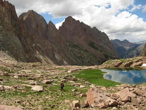
The Weminuche Wilderness Area is Colorado's crown jewel of untamed high-country wilderness, encompassing nearly half a million acres of pristine alpine terrain that embodies the raw, rugged spirit of the Rocky Mountains. As the largest designated wilderness in the state at 499,771 acres—roughly three-quarters the size of Rhode Island—it offers an expansive sanctuary for solitude, adventure, and ecological preservation. Straddling the Continental Divide, the area features jagged fourteen-thousand-foot peaks, glittering glacial lakes, wildflower-strewn meadows, and dense spruce-fir forests, all drained by the headwaters of the mighty Rio Grande and San Juan Rivers. Named for the Weeminuche (or Weminuche) band of the Ute Tribe, who have deep ancestral ties to the land, this wilderness protects fragile ecosystems while providing world-class opportunities for backpacking, mountaineering, fishing, and wildlife viewing. Designated under the 1964 Wilderness Act and expanded multiple times, it remains a testament to conservation efforts, with no roads, mechanized vehicles, or permanent structures allowed to preserve its primitive character. Managed jointly by the U.S. Forest Service (USFS) in the San Juan and Rio Grande National Forests, Weminuche draws hardy adventurers seeking to escape modern conveniences amid some of the most dramatic scenery in the American West.
Weminuche Wilderness lies in southwestern Colorado, primarily within the San Juan Mountains, spanning parts of Archuleta, Hinsdale, La Plata, Mineral, and San Juan counties. It covers the Columbine and Pagosa Ranger Districts of the San Juan National Forest and the Divide Ranger District of the Rio Grande National Forest, with a small contiguous extension managed by the Bureau of Land Management (BLM) as the Weminuche Contiguous Wilderness Study Area (WSA). The wilderness is bisected by approximately 80 miles of the Continental Divide National Scenic Trail, running from Wolf Creek Pass in the south to Stony Pass in the north. Elevations range from about 7,700 feet in forested valleys to over 14,000 feet at its highest points, including three fourteeners: Mount Eolus (14,083 ft), Windom Peak (14,082 ft), and Sunlight Peak (14,059 ft), clustered in the iconic Chicago Basin. The nearest towns are Durango (population ~20,000) to the west, Pagosa Springs to the south, and Silverton to the north, all within 30-60 miles. Access roads like U.S. Highway 550 (Million Dollar Highway) skirt the edges, but the interior is roadless, emphasizing its remoteness. The wilderness borders other protected areas, including the Lizard Head Wilderness to the west and the South San Juan Wilderness to the southeast, forming a vast network of over 1 million acres of public land.
Geographically, Weminuche is a high-alpine mosaic of U-shaped glacial
valleys, cirques, and knife-edge ridges sculpted by ancient ice ages,
with the Continental Divide forming a dramatic spine that separates
watersheds flowing east to the Atlantic (via the Rio Grande) and west to
the Pacific (via the San Juan). The terrain is intensely rugged: steep
talus slopes, narrow passes like Weminuche Pass (10,500 ft), and sheer
granite walls challenge even experienced hikers. Key features include
the Chicago Basin, a mining-era cirque with three fourteeners accessible
only by train or multi-day hike; the Needle Mountains' spires; and
expansive basins like Rincon La Vaca with its alpine lakes and meadows.
Over 500 lakes dot the landscape, fed by snowmelt from a 300+ inch
annual snowfall, creating turquoise tarns that reflect the surrounding
peaks. Forests of Engelmann spruce, subalpine fir, and aspen dominate
lower elevations (8,000-11,000 ft), transitioning to tundra-like alpine
zones above treeline with cushion plants, wildflowers (columbine,
paintbrush), and hardy grasses.
Geologically, the area is part of the
San Juan Volcanic Field, formed around 30 million years ago during
explosive volcanic activity that built massive stratovolcanoes,
including remnants like the Turret-Pigeon Peaks complex. Erosion over
millions of years exposed Precambrian granites, Tertiary volcanics
(andesites and rhyolites), and glacial deposits, creating the sharp,
eroded peaks characteristic of the range. The underlying San Juan
Formation includes ash-flow tuffs from ancient calderas, contributing to
mineral-rich soils that support unique flora. Hydrothermally altered
rocks from past volcanic activity have left colorful banded formations,
while active faulting along the Rio Grande Rift adds to seismic
activity, though rare. The climate is continental alpine: short summers
(June-September) with daytime highs of 50-70°F and nights dipping to
30°F, and long, snowy winters with averages below freezing.
Precipitation peaks in winter snowpack (up to 400 inches in high
basins), sustaining the area's famed wildflowers in July-August.
Weminuche's ecosystems are diverse and fragile, functioning as a
critical watershed for two major rivers and a biodiversity hotspot
in the Southern Rockies. Lower elevations host riparian zones along
creeks teeming with willows, alders, and sedges, providing habitat
for beaver and river otter. Mid-elevations feature mixed conifer
forests with lodgepole pine and Douglas-fir, interspersed with aspen
groves that turn golden in fall. Above 11,000 feet, krummholz
(stunted trees) gives way to alpine tundra, home to rare cushion
plants adapted to harsh winds and short growing seasons. The
wilderness protects endemic species like the Weminuche wild
buckwheat and supports over 200 bird species, including the
endangered willow flycatcher and peregrine falcon. Mammals thrive
here: black bears, mountain lions, elk, mule deer, and bighorn sheep
roam the high country, while smaller critters like pikas, marmots,
and pine martens inhabit rocky talus and subalpine meadows. Fish
populations in lakes and streams include native cutthroat trout and
introduced brook trout, vital for the food web.
Conservation
challenges include climate change-induced shifts: warmer
temperatures have reduced snowpack by 20-30% since the 1980s,
stressing aquatic ecosystems and increasing wildfire risk. A recent
study highlighted algal blooms in remote alpine lakes like those in
the Weminuche, linked to nutrient inputs from pack stock (mules),
prompting collaborative research by the University of Colorado's
Mountain Limnology Lab. The area is a late-successional reserve
under the Northwest Forest Plan, with old-growth stands sequestering
carbon and buffering against erosion. Invasive species like
cheatgrass pose threats, managed through monitoring.
The Weminuche Wilderness has been a vital homeland for Indigenous
peoples for millennia. The Weeminuche band of the Nuche (Ute) people,
meaning "people of the mountains," inhabited the San Juans for at least
1,000 years, using the area for hunting elk and deer, gathering piñon
nuts and berries, and conducting spiritual ceremonies at sacred sites
like high passes and hot springs. Spanish explorers arrived in the
1700s, followed by fur trappers in the 1820s, but major
European-American incursion came with the 1859 Ute Treaty ceding much of
the land. Gold and silver rushes in the 1870s-1880s brought miners to
Chicago Basin, where railroads like the historic Durango & Silverton
Narrow Gauge (still operating) hauled ore from mines like the Boston
Mine. The Utes were forcibly removed to reservations in Utah by 1880,
leading to cultural loss, though descendants maintain ties through the
Southern Ute Indian Tribe and Ute Mountain Ute Tribe.
Conservation
efforts ramped up in the 20th century. Early logging and grazing scarred
the landscape, prompting the 1905 establishment of the San Juan National
Forest. The 1964 Wilderness Act set the stage, and Weminuche was
designated in 1975 as part of the Eastern Wilderness Areas Act,
initially at 423,000 acres. Expansions via the Colorado Wilderness Act
of 1980 (adding 76,000 acres) and 1993 (further adjustments) brought it
to its current size, incorporating volcanic caldera remnants and
protecting against mining claims. In June 2025, an additional ~100 acres
of private inholdings were acquired by the Trust for Public Land and
transferred to the USFS, expanding the wilderness slightly and enhancing
connectivity. Historic sites like old mine ruins and Ute petroglyphs
(scarce due to vandalism) dot the area, reminding visitors of its
layered human story.
Access to Weminuche is primitive by design—no roads penetrate the
interior, enforcing self-reliance. Over 500 miles of trails crisscross
the wilderness, maintained at varying levels (some unmaintained and
overgrown). Primary entry points include:
Durango Area (West
Side): Vallecito Trailhead (via FR 591) leads to 20+ miles of trails to
lakes like Blue, Hunchback, and Chicago Basin (16 miles one-way, popular
for fourteeners). The Durango & Silverton Narrow Gauge Railroad provides
a scenic, motorized exception: summer trains drop hikers at Needleton
(Chicago Basin access) for a $100+ roundtrip fee, with pickups required.
Silverton Area (North): Stony Pass (FR 110, high-clearance 4WD) accesses
the Needle Mountains; Elk Park via train for Eolus/Windom.
Pagosa
Springs Area (South): Wolf Creek Pass (US 160) to Lobo Trailhead for the
Continental Divide Trail (CDT) south segment.
Creede Area (East): Rio
Grande Reservoir (FR 520) to Weminuche Pass Trail #818 (5.5 miles to the
pass, connecting to San Juan NF trails).
The CDT traverses 70-80
miles through the heart, from Cimarron Creek to the Los Pinos River,
with huts like the Windom Hut available for $40/night (reservations via
the Chicago Basin Huts system). Horses and llamas are allowed (25 total
per group with stock), but no bikes or drones. Group size capped at 15
people (25 with stock); dogs must be leashed. No permits needed for
overnight use, but register at trailheads and follow fire restrictions
(campfires banned in some areas). Expect 4-7 days for traverses; water
sources abound but treat all.
Weminuche excels in backcountry pursuits: backpacking loops like the Rincon La Vaca (20-30 miles, alpine lakes); mountaineering in Chicago Basin (class 3-5 scrambles on fourteeners); fishing for cutthroat in streams like the Los Pinos; and winter snowshoeing/skiing (permit-free but avalanche-prone). Hunting (deer, elk seasons) and gathering (limited mushrooms/berries) are allowed with state licenses. The area's remoteness ensures solitude—Chicago Basin sees 1,000-2,000 visitors annually via train. Guided outfitters offer llama treks or fishing trips for $200+/day. Leave No Trace is mandatory: bury waste 6-8 inches, pack out trash, and camp 100 feet from water/trails.
Jointly managed by USFS rangers from Durango (970-247-4874) and Saguache (719-655-2547) offices, Weminuche follows the 1995 San Juan Forest Plan, emphasizing non-motorized recreation and ecosystem restoration. Specific regs prohibit camping within 100 feet of trails/lakes (¼ mile at sensitive sites like Little Emerald and Flint Lakes) and limit stock grazing. Fire management includes prescribed burns to mimic natural regimes, countering the 2018 Spring Creek Fire's legacy (burned 108,000 acres nearby). Climate adaptation focuses on trail resilience and invasive control. Tribal consultations with Ute nations protect cultural sites. In 2025, expansions bolstered protections against development.
Prime season is mid-June to mid-September, when snowmelt reveals trails and wildflowers peak in July. Early summer risks high water crossings; late September offers fall colors but early snow. Winter (Dec-April) suits experts with 10-15 ft snowpack, but access is ski-only. Current conditions (September 9, 2025): Trails are mostly snow-free, with mild highs (60-70°F) and cool nights (30-40°F); no major closures or fires reported, but monsoon remnants may bring afternoon thunderstorms—check fs.usda.gov/sanjuan for updates. Annual visitors: ~50,000, concentrated in Chicago Basin.
This is strenuous wilderness—train for 10+ mile days with 2,000+ ft elevation gain. Pack a 4-season tent, bear canister (bears active), water filter (giardia risk), and navigation (GPS/maps; no cell service). Start early to avoid lightning; acclimatize to 10,000+ ft. For Chicago Basin, book train 3-6 months ahead (durangotrain.com). Budget $50-100/day for food/gear; free dispersed camping. Emergencies: Satellite messenger essential; rescues can take days. Respect Ute heritage—avoid disturbing artifacts.
Weminuche's Chicago Basin is one of Colorado's most remote
fourteeners clusters, requiring a 6-7 mile hike from the train drop-off.
The area's volcanic past includes the Silverton Caldera; hot springs
like those on the West Fork San Juan are culturally sacred.
Recent
2025 land addition included former private ranches, preventing
subdivision and adding vital elk habitat.
The CDT through Weminuche
is part of the 3,100-mile trail from Mexico to Canada, with sections
rated "most scenic" by hikers.
A 2025 study used pack mules to sample
remote lakes, revealing nitrogen pollution from stock waste turning
waters green.
Historic mining left "ghost" structures, but the 1993
expansion banned new claims, preserving the basin's wild feel.
Weminuche Wilderness invites those willing to earn its beauty through
effort, rewarding with profound isolation and timeless landscapes that
feel worlds away from civilization.