Location: Otero Country, NM Map
Area: 581 km²
Info: (575) 679- 2599
Open: 8am- 7pm daily (5pm in winter months)
Closed: Dec. 25
Official site
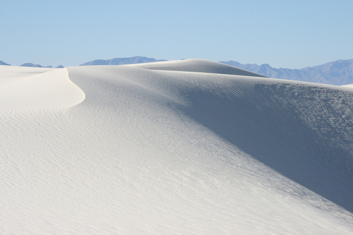
White Sands National Park, located in the heart of New Mexico's Chihuahuan Desert, is a surreal landscape of undulating white gypsum dunes that stretch across 275 square miles, encompassing the largest gypsum dunefield on Earth. Established as White Sands National Monument on January 18, 1933, by President Herbert Hoover to protect this otherworldly expanse of "white sands and additional features of scenic, scientific, and educational interest," it was redesignated as a national park on December 20, 2019, by President Donald Trump, becoming the 62nd U.S. national park and the sixth in New Mexico. This elevation from monument to park status enhanced its protection and recognition, reflecting its unparalleled geological, ecological, and cultural value. Managed by the National Park Service (NPS), the park preserves not only the shimmering dunes but also the resilient plants, animals, and ancient human and animal trackways that reveal a dynamic history spanning over 10,000 years. Often described as "like no place else on Earth," White Sands draws over 600,000 visitors annually, offering experiences from dune sledding to stargazing, while its adjacency to the White Sands Missile Range ties it to pivotal chapters in American military and space exploration history. The park's gypsum sands, which sparkle under the sun and glow ethereally at night, symbolize natural resilience in an arid environment, educating visitors on adaptation, preservation, and the intersection of science and wilderness.
White Sands National Park lies in the Tularosa Basin of southern New
Mexico, straddling Otero and Doña Ana counties, approximately 15 miles
southwest of Alamogordo, 50 miles northeast of Las Cruces, and adjacent
to Holloman Air Force Base and the White Sands Missile Range. The main
entrance is off U.S. Highway 70, with a visitor center at the north end
of the 8-mile Dunes Drive. The park's coordinates center around 32°46′N
106°10′W, at an elevation of about 4,235 feet (1,291 meters), within the
expansive 115-mile-long Tularosa Basin—a closed intermontane valley
formed by tectonic uplift of the surrounding San Andres, Sacramento, and
Organ Mountains.
Geologically, the dunes originate from gypsum
(calcium sulfate) dissolved from Permian-era bedrock in the nearby
mountains, carried by wind and water from ancient Lake Otero (a massive
Pleistocene lake that covered 1,600 square miles until about 10,000
years ago). As the lake evaporated, selenite crystals formed on its bed
(now Alkali Flat), which wind eroded into fine, white sand
particles—lighter and cooler than quartz sands, rarely exceeding 140°F
even in summer. Prevailing northeasterly winds sculpt the dunes into
ever-shifting waves up to 60 feet high, with the dunefield covering
about 40% of the basin and constantly migrating westward at 10–20 feet
per year. The ecosystem is a harsh Chihuahuan Desert variant, with
shallow groundwater and limited rainfall (about 10–12 inches annually),
supporting over 800 animal species and specialized plants like soaptree
yucca, Apache plume, and four-wing saltbush that anchor the dunes with
deep roots. Fauna includes adapted species such as the bleached earless
lizard (camouflaged white), Ord's kangaroo rat, and lesser nighthawks,
alongside birds like roadrunners and insects forming cyanobacterial soil
crusts that prevent erosion.
The climate is semi-arid and extreme:
sunny skies dominate 330 days a year, with summer highs averaging 97°F
(36°C) and often exceeding 100°F, dropping to lows in the 60s°F at
night; winters average 60°F daytime but plunge to the low 20s°F
overnight, with occasional snow dusting the dunes in a rare
"sugar-on-snow" effect. Monsoon season (July–mid-October) brings
afternoon thunderstorms, flash floods, and most precipitation, while
spring winds can whip up haboobs (dust storms). Environmental challenges
include invasive saltcedar trees consuming up to 200 gallons of water
daily, climate-driven evaporation accelerating dune loss, and rising
temperatures threatening the delicate balance of rain, sun, wind, and
groundwater that sustains the system.
Human history at White Sands spans millennia, beginning with
Paleo-Indians over 10,000 years ago who hunted mammoth and giant sloth
along Lake Otero's shores, leaving fossilized trackways—human footprints
alongside those of dire wolves, camels, and sloths—preserved in the
gypsum sediments. These trackways, some extending two miles, provide the
earliest evidence of human presence in the Americas, with a 2025 study
in Science Advances confirming dates around 21,000–23,000 years ago,
predating the end of the last Ice Age and challenging traditional
migration theories. Indigenous groups like the Mescalero Apache, who
called the area "the land of the white sands," used it for hunting,
gathering salt, and spiritual practices, viewing the dunes as a sacred,
ever-changing entity. Spanish explorers in the 16th century traversed
the basin, followed by 19th-century miners extracting gypsum and salt,
and ranchers grazing cattle on the grasslands until the early 20th
century.
The modern era intertwined the site with American innovation
and conflict. In 1942, amid World War II, the U.S. Army seized much of
the Tularosa Basin for the Alamogordo Bombing Range, later expanded into
the White Sands Proving Ground (1945) and White Sands Missile Range
(WSMR). The Trinity Site, within the restricted range adjacent to the
park, hosted the world's first atomic bomb test on July 16, 1945,
marking the dawn of the nuclear age. Postwar, WSMR became the cradle of
rocketry: captured German V-2 rockets launched here in 1946 were the
first large-scale missiles fired on U.S. soil, paving the way for NASA's
space program. By 1963, NASA established the White Sands Test Facility
for shuttle solid rocket booster testing and astronaut training,
contributing to missions like Apollo and the Space Shuttle. The national
monument's creation in 1933 predated these developments, but military
overflights and testing necessitated careful management to protect the
dunes.
Culturally, White Sands has inspired art, film (e.g., Star
Wars scenes and music videos), and literature, symbolizing isolation and
transformation. The park's historic district, including the 1910s Lucero
Ranch (a National Register-listed site), preserves ranching heritage,
while oral histories from Apache descendants and early rangers highlight
multicultural narratives. The 2019 redesignation amplified its status,
increasing funding for preservation and Indigenous consultations,
underscoring its role as a bridge between ancient ecology and modern
science.
The park's crown jewel is the gypsum dunefield itself, a vast sea of
blinding white waves framed by the Sierra Blanca peaks. Dunes Drive, an
8-mile paved scenic road, winds through the heart of the dunes with
pullouts for exhibits on geology and ecology, picnic areas (Yucca,
Roadrunner, Primrose), and access points for exploration. The visitor
center, near the entrance, houses an interactive museum with a native
plant garden, an award-winning film, and a gift shop selling sleds and
souvenirs.
Trails offer immersive adventures: the Interdune Boardwalk
(0.4-mile accessible loop) introduces dune life with signs on
adaptations; Dune Life Nature Trail (1-mile loop) reveals hidden
ecosystems amid dunes; Bigfoot Trail (0.5-mile) explores wildlife
tracks; and the challenging Alkali Flat Trail (5 miles round-trip, 5
hours) leads to the dunefield's high point on the old lakebed, rewarding
hikers with panoramic views and solitude (permit required for groups
over 5). Fossilized trackways, viewable on ranger-led hikes, showcase
Ice Age drama, with human prints intermingled with extinct megafauna.
Unique phenomena include "trenching," where visitors dig shallow holes
for "lakes" that fill with groundwater, and the dunes' acoustic
properties amplifying sounds.
Attractions extend to celestial
wonders: the park's dark skies host stargazing programs, revealing the
Milky Way against the luminous sands. Backcountry camping at 10
primitive sites (first-come, first-served, currently closed as of 2025)
allows overnight immersion, while the historic Lucero Ranch offers
glimpses of frontier life.
As of September 9, 2025, White Sands National Park is open daily,
with hours varying seasonally (typically 7 a.m. to sunset in summer, 8
a.m. to 5 p.m. in winter; confirm via NPS app or phone). Entrance fees
are $25 per vehicle (valid 7 days), $15 per individual (bike/walk-in),
free for children 15 and under; America the Beautiful passes ($80
annual) are accepted, and fee-free days occur several times yearly. No
reservations needed for entry, but backcountry permits ($5–$10) and some
programs require advance booking via recreation.gov. Access is via
US-70; a 4WD high-clearance vehicle is recommended for backcountry
roads, though most activities are along Dunes Drive.
Activities blend
adventure and education: dune sledding (using park-approved plastic
saucers, $15–$20 at gift shop) on gentle slopes in the drive's
loop—technique involves belly-down launches for speeds up to 30 mph.
Hiking the 10+ miles of marked trails suits all levels, with 300+ miles
of unmarked routes for experts. Ranger-led programs (seasonal, free)
include full moon hikes, sunset strolls, geology talks, and Junior
Ranger activities for kids (badges earned in 1–2 hours). Stargazing and
photography thrive year-round, especially during new moons. Picnicking
is popular at shaded areas (bring your own food; limited concessions).
No frontcountry camping, but primitive backcountry sites offer solitude
(closed currently; check updates). Nearby Alamogordo provides lodging,
dining, and the New Mexico Museum of Space History.
Accessibility
includes wheelchair-friendly boardwalks, dune wheelchairs (free,
reservation needed), and audio guides. Best times: spring (March–May)
for mild 70–80°F weather and wildflowers, or fall (September–November)
for fewer crowds and post-monsoon clarity; avoid midday summer heat.
Safety is paramount: pack 1 gallon of water/person/day, salty snacks,
sunscreen, hats, closed-toe shoes (for scorpions/rattlesnakes), and
layers for temperature swings. Hazards include heat exhaustion
(symptoms: nausea, cramps; treat with shade/water), disorientation
(dunes shift; use orange trail markers, don't rely on GPS), sudden
storms, and unstable sand collapses when digging. Cell service is
spotty—rent satellite messengers if venturing far. Alcohol is banned
February 1–May 31 for safety; elsewhere, limited to picnic areas.
Closures occur for WSMR missile tests (up to 3 hours, visitor center
open); Dunes Drive shuts September 24 (7–9 a.m.) and September 26 (7–9
a.m.), with US-70 potentially blocked—call (575) 678-1178 or check
nps.gov/whsa for status. A safety corridor is active between mile
markers 3–5.5 on Dunes Drive (drive but no stopping).
Preservation focuses on stabilizing the dynamic dunes through
invasive species removal (e.g., saltcedar) and monitoring climate
impacts like accelerated evaporation from warming temperatures, which
could erode the field. NPS collaborates with WSMR for noise/overflight
mitigation and with tribes like the Mescalero Apache for cultural
resource protection, including trackway conservation. Fossil sites are
off-limits to prevent damage, and regulations ban sand removal (fines up
to $5,000/jail). The 2019 redesignation boosted funding for
infrastructure, like dune stabilization and accessibility upgrades.
As of 2025, recent highlights include a June Science Advances study
affirming the 21,000+ year-old human footprints as genuine, reshaping
peopling-of-the-Americas debates. A June 11 full moon night event drew
crowds for guided dune walks. In August, NASA tested "LASSIE," a
quadrupedal robot dog, in the dunes to simulate lunar/Martian terrains
for future astronaut support. Dunes Drive remains open with the ongoing
safety corridor. No major closures beyond scheduled tests; the park
emphasizes Leave No Trace to combat overuse. Future plans include
expanded ranger programs and tech for real-time erosion tracking,
ensuring White Sands endures as a beacon of scientific wonder and
natural artistry.