Location: Tuolumne, Mariposa, Madera Counties Map
Area: 761,266 acres (308,073 ha)
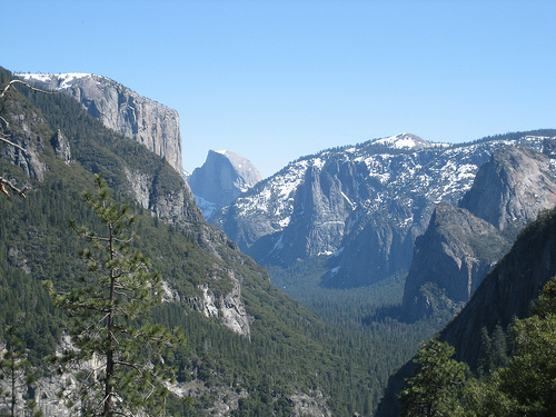
Yosemite National Park is a national park located in Madera,
Mariposa, and Tuolumne counties, California (USA). It covers an area
of 3081 km² and is located on the western slopes of the Sierra
Nevada mountain range. It is famous for its landscapes and nature:
impressive granite cliffs, waterfalls, rivers with clear water,
sequoiadendron groves and rich biological diversity (almost 95% of
the park is considered a wilderness area). In 1984, the park
received the status of "World Heritage" under the auspices of
UNESCO. It was conceived from the very beginning as a national park
(although national parks existed before). Among its organizers is
one of the first defenders of the idea of reserves, John Muir. Every
year the park is visited by 4-5 million people; most stop only in
Yosemite Valley.
The park is one of the largest and undivided
wildlife conservation areas in the Sierra Nevada region; The local
fauna and flora are extremely diverse. Located at an altitude of 600
to 4000 m above sea level, the park includes five main vegetation
zones: dense thickets of shrubs and oaks, lower mountain forest,
upper mountain forest, subalpine and alpine belts. Of the 7,000
species of plants growing in California, about half are found in the
Sierra Nevada mountains, and a fifth in the park itself. Here, as a
result of a rare geological formation and unique soils, it is a
convenient place for the growth of more than 160 rare plant species.
The geological structure of the park is characterized by the
presence of granite and remains of even more ancient rocks. About 10
million years ago, the Sierra Nevada mountains rose and then tilted
in such a way that the western slope became more gentle, and the
eastern one, facing the mainland, more steep. The uplift increased
the steepness of water flows and river beds, resulting in the
formation of deep and narrow canyons. About a million years ago,
snow and ice accumulated on the peaks formed glaciers in the regions
of the modern subalpine and alpine belts, thus lowering the river
valleys down the slope. During the first ice age, the ice thickness
in the glaciers was up to 1200 m. Further sliding of the glacial
masses formed a trough (U-shaped) valley, which currently attracts a
lot of tourists hunting for beautiful landscapes.
Yosemite National Park is located in the central part of the Sierra
Nevada range in the US state of California. It is 3.5 hours from San
Francisco and approximately 6 hours from Los Angeles. It is surrounded
by a series of protected wilderness areas: Ansel Adams to the southeast,
Hoover to the northeast, and Emigrant to the north.
On an area of
3081 km² there are thousands of lakes and ponds, 2600 rivers and
streams, 1300 km of tourist routes and 560 km of roads. Two federal
rivers, the Merced and the Tuolumne, originate within the boundaries of
the park and flow further into the California Valley. More than 3.5
million tourists visit the park every year, most of whom concentrate on
the 18 km² of Yosemite Valley.
Rocks and erosion
Almost the
entire territory of the park is composed of granite rocks of the Sierra
Nevada batholith. The remaining about 5% of the park (mainly on the
eastern border near Mount Dana (eng. Mount Dana)) consists of
metamorphosed volcanic and sedimentary rocks. These rocks are referred
to as the so-called "roof sagging", because they were once the roof for
the underlying granitic magma.
As a result of the erosion of
various rocks that experienced tectonic uplift and the accompanying
faults, valleys, canyons, dome-shaped folds and other landforms appeared
that we can see today (these joints and cracks do not move, therefore
there is no geological fault). Air spaces between joints and cracks are
formed due to the presence of silicon dioxide in granite and
granodiorite; more silica content results in more space and more stable
rock.
Natural pillars and columns such as Washington Column and
Lost Arrow were formed as a result of cross-connection. As a result of
erosion of the main crack, valleys and later canyons were formed. The
most powerful erosive force in the last few million years has been the
melting of glaciers in the Alpine belt, turning originally V-shaped
river valleys into U-shaped glacial canyons (such as the Yosemite and
Hetch Hetchy valleys). As a result of secondary fracturing (formed as a
result of the tendency of igneous rock crystals to expand), granite
domes such as Half Dome and North Dome were formed.
Popular
routes
Yosemite Valley occupies only one percent of the total area of
the park, but it is there that most visitors flock. One of the most
popular objects in the world among rock climbers with routes of
different difficulty levels is the El Capitan granite rock, 2307 m above
sea level, clearly visible from any part of the valley, on the eastern
slope of which for several days in February you can see a rare
phenomenon - the reflection of the rays of the setting sun in the
falling stream of the so-called waterfall. "fiery" waterfall "Horsetail"
(Eng. Horsetail Fall). Impressive granite dome-shaped folds such as the
Sentinel Dome and Half Dome rise to a height of 900 and 1450 m
respectively above the valley floor.
In the upper part of the
park you can find such beautiful natural places as the Tuolumne Meadows
(English Tuolumne Meadows), Dana Meadows (English Dana Meadows), Clark
Range, Cathedral Range and the ridge Kuna (eng. Kuna Crest). The Sierra
crest and Pacific Crest mountain hiking trails run through the park
along the ridge of the mountains, passing through peaks composed of red
metamorphic rock, such as Mount Deyna and Mount Gibbs (Eng. Mount
Gibbs), as well as over granite peaks such as Mount Conness. The highest
point in the park is Mount Lyell at 3,997 meters above sea level.
There are three groves of ancient sequoiadendron trees in the park:
Mariposa (English Mariposa Grove, 200 trees), Tuolumne (English Tuolumne
Grove, 25 trees) and Merced (English Merced Grove, 20 trees).
Sequoiadendron trees are considered the most massive and one of the
tallest and longest-lived trees in the world - growing trees in the park
appeared even before the start of the last ice age.
Yosemite National Park is a popular destination for mountain climbers
and especially El Capital stands out among other peaks. It is a granite
cliff that reaches a height of 2,307 meters. Horsetail Waterfall flows
from the eastern slope of the mountain.
The Great Wall was
viewed as impossible to climb just several decades ago, but several dare
devils disproved this point of view. Camp 4 is located at the base of
the ascent where climbers prepare for their climb of El Capitan. In
addition to those who climb up, this cliff became popular among those
who try to jump down. Base jumpers also use this cliff or their jumps
into Yosemite Valley below.
There are a large number of waterfalls in the park in a limited area,
among which the following can be noted:
Bridlevale - 190 m
Horse
Tail – 650 m
Chilnualna - 210 m
Illilloett - 110 m
Lehamit -
360 m
Nevada - 180 m
Ribbon - 492 m
Royal Arch Cascade - 370 m
Sentinel - 585 m
Silver Strand - 175 m
Snow Creek - 652 m
Stercase - 310 m
Tuilala - 256 m
Vernal - 96 m
Wapama - 520 m
Waterville - 90 m
Wildcat - 192 m
Yosemite - 739 m
Horsetail Waterfall is one of the most famous landmarks in the
Yosemite valley. It falls from a cliff on the eastern slope of El
Capitan mountain. It is not extremely high or powerful, but in
combination with a Yosemite Valley it is one of most recognizable
landscapes in the Western United States. The best time to see it is in
late winter and spring when the water stream is the strongest due to
melting snow and ice. You can hear the noise of falling water for
several miles in all direction. However, by early summer waterfall
dwindles and is barely visible from a viewing area.
Horsetail
Waterfall is commonly visited in February by people who want to snap a
photo of a famous "Fire Fall". This nickname was coined by photographer
Galen Rowell who took a picture in late winter. Falling water was hit by
setting sun, giving water its distinct orange appearance that looked
like a flowing lava. Famous photographer didn't specify the exact
location or time of the day when he made his famous image, but many
people come in hopes to catch a similar breathtaking view.
The rivers Tuolumne and Merced, originating in the upper
reaches of the mountains in the park, carved river canyons
with a depth of 900 to 1200 m. The basin of the Tuolumne
river in the park is approximately 1760 km², it absorbs the
water of the entire northern part of the park. The Merced
River, on the contrary, flows from the southern peaks of the
territory (mainly the Cathedral and Krark ranges) and its
basin is approximately 1320 km².
Hydrological
processes, including icing, floods and fluvial
geomorphological cycles, were a decisive factor in the
creation of the natural landscapes of the park. In addition
to the two main rivers, the park has 3200 lakes with an area
of more than 100 m² each, 2 reservoirs and about 2700 km of
various rivers and streams, each of which is included in one
of the two watersheds. Wetlands form at the bottom of the
valley throughout the park, often associated with nearby
lakes and rivers by groundwater and seasonal flooding.
Meadows at an altitude of 300 to 3500 m above sea level are
also often swampy, as they are located along flowing rivers
and streams.
Multiple sheer cliffs, glacial ledges,
and hanging valleys (i.e., side valleys whose bottoms are
higher than the bottom of the main valley) provide good
ground for waterfalls, especially during the snowmelt
seasons of spring and summer. At 739m, Yosemite Falls is the
tallest waterfall in North America and is the 20th tallest
waterfall in the world. The much smaller Ribbon Falls,
however, is the waterfall with the highest point of
unimpeded water fall - 492 m. Perhaps the most scenic
waterfall in the park is Bridalveil Falls (Bridal Veil),
clearly visible from a nearby road.
The glaciers in
the park are relatively small in size and occupy areas that
are mostly in the shade. Lyell Glacier, the largest glacier
in the Sierra Nevada, and Yosemite Park respectively, covers
an area of 65 hectares. None of the present-day glaciers are
remnants of the huge ice age alpine glaciers responsible for
altering the park's natural landscape. They formed during
times of relative cooling of the Earth's climate, such as
the Little Ice Age in the 14th-17th centuries. Global
warming has reduced the number and size of glaciers around
the world, including in the Sierra Nevada. Many of the
park's glaciers, discovered in 1871 by John Muir, are now
either completely gone or have lost up to 75% of their
surface.
The climate in the park is Mediterranean, that is, most of the
average annual precipitation occurs during mild winters; at other
times of the year, the climate is relatively dry (less than 3% of
precipitation per year occurs during hot summers). Due to orographic
uplift, precipitation increases with altitude up to about 2400 m,
and then decreases sharply. The amount of precipitation varies from
915 mm at an altitude of 1200 m above sea level to 1200 mm at an
altitude of 2600 m. At the top, the snow cover forms in November and
lasts until March - early April.
The temperature decreases
with increasing altitude. An extremely important factor in the
temperature regime is that Yosemite National Park is located only
160 km from the Pacific Ocean. Highs that form in the summer off the
coast of California send cool air masses towards the Sierra Nevada
and bring clean, dry air into the park as a result.
The
average daily temperature in the Tuolumne meadows at an altitude of
2600 m ranges from −3.9 to 11.5 °C. At the southern entrance to the
park at an altitude of 1887 m, the temperature ranges from 2.2 to
19.4 °C. At lower altitudes, the air warms up more, the average
daily maximum temperature at the bottom of the valley (altitude 1209
m varies from 7.8 to 32.2 ° C. Above 2440 m, high and dry summer
temperatures are maintained due to frequent thunderstorms, although
stale snow can keep up until July.Due to the dry growing season,
relatively low humidity and heavy thunderstorms, fires often occur
in the park.
To date, there has been debate among historians as to who was the
first European to see Yosemite Valley. In the autumn of 1833, Joseph
Reddeford Walker may have been the first to see the valley - in his
subsequent notes, he said that he led a group of hunters that crossed
the Sierra Nevada and came close to the edge of the valley, which went
down "more than a mile." His party was also the first to be in
Tuolomni's grove of sequoiadendron trees, thus becoming the first
non-locals to see these giant trees.
Part of the territory of the
Sierra Nevada, where the park is located, has long been considered the
border of the settlements of Europeans, traders, hunters and travelers.
However, this status changed in 1848 with the discovery of gold deposits
at the foot of the mountains in the west. Since that moment, trading
activity in this territory has increased dramatically, as a result,
provoking the California gold rush. Newcomers began to destroy the
natural resources, due to which the Indian tribes lived. The first
authentically known white man who saw the valley should be considered
William P. Abrams, who on October 18, 1849, with his detachment
accurately described some of the landmarks of the valley, but it is not
known for sure whether he or any of his detachment entered the this
land. However, there is no doubt that in 1850 Joseph Screech actually
descended into the Hetch Hetchy valley and, moreover, settled here.
The first systematic study of the park area was carried out in 1855
by the team of Alexey W. Von Schmidt (Allexey W. Von Schmidt) as part of
the state land survey program "Public Land Survey System".
Mariposa Wars
Before the first Europeans appeared in this territory,
the Sierra Miwok and Payute Indian tribes lived here. By the time the
first settlers arrived, Yosemite Valley was inhabited by a group of
Indians who called themselves the Avanichi (Ahwahnechee).
As a
result of a sharp increase in the flow of immigrants during the gold
rush, armed conflicts began to arise with local tribes. To put an end to
the constant skirmishes, in 1851, government troops were sent to the
valley - the Mariposa battalion under the command of Major James Savage
in order to pursue about 200 Avanichi Indians, led by the leader Tenaya.
In particular, the doctor Lafayette Bunnell was attached to the
detachment, who later vividly described his impressions of what he saw
in the book The Discovery of the Yosemite. Bunnell is also credited with
the authorship of the name of the valley, which he gave after a
conversation with the leader of Tenai.
Bunnell wrote in his book
that Chief Tenai was the founder of the Pai-Ute colony of the Ah-wah-ne
tribe. The Indians of the neighboring Sierra Miwok tribe (like most of
the white residents who settled there) described the Awanichi Indians as
a warlike tribe with which they had constant territorial disputes, the
name of this tribe "yohhe'meti" literally means "they are murderers."
Correspondence and notes written by the soldiers of the battalion
contributed to the popularization of the valley and its surrounding
area.
Tenaya and the remnants of the Avanichi tribe were taken
prisoner, and their settlement was burned. The tribe was forcibly
transferred to a reservation near Fresno, California. Some were
subsequently allowed to return to the valley, but after an attack on
eight miners in 1852, they fled to the neighboring Mono tribe, who
violated the laws of hospitality and killed them.
Early tourism
period
Entrepreneur James Mason Hutchings, artist Thomas Ayres and
two other travelers became the first tourists to the valley, having
arrived here in 1855. Huchings produced booklets and books describing
his tour, and Ayres' drawings became the first professional depictions
of local landmarks. Photographer Charles Leander Weed took his first
photographs of the valley in 1859.
In the southwest of the park
is the old Wawona Indian camp, which now has about 160 permanent
residents. In the area of this camp in 1857, local resident Galen Clark
discovered groves of sequoiadendron trees. Temporary dwellings were
built on the site of the camp and roads were laid. In 1879, the Wawona
Hotel opened to serve arriving tourists. As tourism continued to grow,
new hotels and hiking trails emerged.
Yosemite Grant
Several
prominent people, including Galen Clark and Senator John Conness, became
interested in the commercial success of the tourism business and came up
with the idea of creating a public park in the valley. On June 30,
1864, US President Abraham Lincoln signed a document previously approved
by Congress called the Yosemite Grant. Yosemite Valley and Mariposa
Grove were ceded to California, granted state park status, and two years
later a board of commissioners was appointed. The grant is considered a
significant step in US history as it precedes the establishment of
Yellowstone National Park, officially the world's first national park.
On the uniform of the park workers, you can see the image of a
sequoiadendron, which indicates the great importance of these trees in
the idea of \u200b\u200bcreating a national park.
Galen Clark was
appointed chief keeper of the park by the commission, but neither he nor
the commission itself had the authority to evict local residents,
including Huchings. The problem was resolved in 1875 when the local
landholdings were invalidated. In 1880, Clarke and the ruling
commissioners were dismissed, and Huchings became the new park keeper.
In the very first years, the access of visitors to the park was
greatly facilitated, and the conditions of stay in it became more
hospitable. After the construction of the First Transcontinental
Railroad in 1869, the influx of visitors to the park began to increase
markedly, but nevertheless, the long journey on horseback to directly
enter the park was a deterrent. In the mid-1870s, three stagecoach roads
were laid, which boosted the valley's traffic.
Scottish-born
naturalist John Muir has written a number of articles to draw attention
to the area and promote scientific interest in it. Muir was one of the
first to suggest that the main landscapes of the park were created using
huge glaciers, while opposing such authoritative scientists as Josiah
Dwight Whitney, who considered Muir an amateur.
Overgrazing of pastures (mainly sheep), cutting down sequoiadendron
trees and other activities that damage nature forced John Muir to come
up with the idea of tightening the conditions for protecting this
territory. Muir urged influential visitors on the need for federal
protection for the park. One such visitor was Century Magazine publisher
Robert Underwood Johnson. With the help of Johnson, Muir helped pass an
act of Congress that gave the park national status on October 1, 1890.
Despite this, the state of California still retained control of the
valley and grove. Muir also persuaded the local authorities not to graze
cattle in the alpine meadows.
On May 19, 1891, the park came
under the protection of the Fourth Cavalry Regiment of the US Army,
which set up its base in Wavon. By the end of the 1890s, grazing was no
longer a problem, and the army turned to other improvements to the area.
Muir and the Sierra Club he created continued to lobby the US
government and powerful people to create a unified Yosemite National
Park. In May 1903, US President Theodore Roosevelt visited the park and
spent three days there, meeting with Muir. The result of this meeting
was the signing in 1906 by Roosevelt of a decree in which all control of
the park passed to the federal government.
20th century
In
1916, a government service was formed to take care of the park. Roads,
hunting lodges and campsites were built along the lakes. With the
development of automobile traffic, high-speed highways were laid to the
park. The Yosemite Museum was founded in the 1920s.
To the north
of the Yosemite Valley in the park is another Hetch Hatch valley, which
they decided to use to drain water and create a reservoir and
hydroelectric power station there to supply electricity to San
Francisco. This decision caused heated debate among supporters and
opponents of the project, but the project was still approved by Congress
in 1913.
In response, conservationists urged Congress to
designate 2,742 km², or 89% of the entire park, as the highest protected
natural area. As a result, visitors were not allowed to visit much of
the park. Traffic jams in the summer also became a problem, and it was
proposed to let cars through in the summer only for vacationers with a
reserved hotel or campsite. This approach will force visitors to use the
shuttle bus, bike or walk 11 km.
In the first half of the
century, the national park was captured in the works of the famous
American landscape photographer Ansel Adams.
Tectonic volcanic activity
During the Precambrian and the early
Paleozoic era, the territory of the park was located on the underwater
margin of the mainland. In shallow water, sedimentary rocks were formed
from continental deposits, which subsequently underwent metamorphism.
During the late Devonian and Permian geologic periods, the ancient
Farallon tectonic plate began to subduct under the N American Plate in a
subduction zone, and the ensuing volcanic activity formed an arc of
volcanic islands west of the North American coast. Later, during the
Jurassic period, volcanic activity intruded (mixed) and covered the
resulting rocks with magma, which was the beginning of the formation of
the Sierra Nevada batholith. Ultimately, 95% of the resulting rocks were
eroded away by surface uplift.
The first stage of regional
plutonism began approximately 210 Ma at the end of the Triassic and
continued through the Jurassic 150 Ma. At this time, the so-called
Nevadan orogeny (orogeny - mountain building, the process of deformation
of the earth's crust, occurring in geosynclinal areas and leading to the
formation of folded mountain structures) raised the earth's surface and
as a result, the Nevadan mountain system appeared with a height of up to
4500 m above sea level, which became the progenitor in the modern Sierra
Nevada. During this period, to a depth of up to 10 km, mountain rocks,
mainly consisting of granite, were formed. The second stage of mountain
building occurred between 120 and 80 million years ago during the
Cretaceous period and was called the Sevier orogeny.
During the
Cenozoic, between 20 and 5 million years ago, a series of volcanic
eruptions (now extinct) occurred in the Cascade Mountains, resulting in
a large amount of igneous rock covering the area north of Yosemite Park.
Volcanic activity has continued for the last 5 Ma to the east of the
park boundaries in the areas of Mono Lake and the Long Valley Caldera.
Starting from 10 million years ago, the vertical movement of earth
masses along the Sierra geological fault began to raise the mountains of
the Sierra Nevada. The subsequent slope of the mountain range to the
west resulted in an increase in the gradient of water flows flowing down
the western slopes of the range. Rivers westward began to flow faster,
and accordingly, carve out valleys and canyons at a faster rate. The
mountains were still uplifted after the formation of large faults in the
east and the formation of the Owens Valley. Approximately 2 million
years ago, during the Pleistocene epoch, the uplift of the Sierra Nevada
accelerated again.
As a result of the uplift of the mountains,
the granite rocks began to experience increasing pressure, and they
began to desquamate, the separation of layers, which was expressed in
the rounded shape of many domes of the park, and also numerous
landslides began, followed by numerous cracks in the separation planes
(especially vertical ones) in frozen intrusions. Later glaciers
accelerated this process and created scree and glacial deposits on the
valley floor.
By the number and nature of the vertical planes of
separation, it is possible to determine where and how erosion occurred.
Most of the long, linear and deep cracks are directed to the northeast
or northwest and are parallel, often evenly spaced lines. They were
formed under the pressure of the rising surface and crumbling overlying
rocks.
Between 2 and 3 million years ago, the beginning of the formation of
glaciers continued to change the natural landscape of the park. At least
four large glaciers were formed on the territory of the Sierra Nevada:
Sherwin, Tahoe, Tenaya and Tioga. The largest was Sherwin, it occupied
the area of Yosemite Park and the surrounding valleys. It was as a
result of the action of this glacier that the modern outlines of the
Yosemite Valley and the nearest canyons appeared.
Glaciers
descended down to 1200 m above sea level and left their marks throughout
the park. The longest glacier in the Yosemite region extended down the
Grand Canyon of the Tuolomne River for 95 km, passing far beyond the
Hetch Hetchy valley. The Merced Glacier has carved out the Yosemite
Valley. The Lee Vining Glacier formed the Lee Vining Canyon and Lake
Russel. Glaciers were absent only on the highest peaks - Mounts Dana and
Conness. Melting glaciers very often left behind moraines that filled
lakes like Yosemite Lake (a shallow lake that periodically floods the
floor of Yosemite Valley).
In the various natural landscapes of the park, ranging from thickets
of thorny bushes in the foothills to alpine meadows on the tops of the
mountains, there are more than 250 species of vertebrates, which include
fish, amphibians, reptiles, birds and mammals. The great biodiversity
compared to other nearby regions is also due to the untouched
wilderness, where human activities do not contribute to their
degradation and extinction.
Along the western border of the park,
mixed coniferous forests dominate, in which yellow pine, Lambert pine
(lat. Pinus lambertiana), calocedrus (lat. Calocedrus), monochromatic
fir (lat. Abies concolor), pseudohemlock, several sequoiadendrons, and
oak groves grow. velvety (lat. Quercus velutina). Due to the relatively
mild foothill climate and mixed natural biomes, there is a fairly large
variety of animals here, including the baribal bear, bobcat, gray fox
(lat. Urocyon cinereoargenteus), black-tailed deer, Arizona king snake
(lat. Lampropeltis pyromelana), western long-legged skink (lat. .
Eumeces gilberti), white-headed woodpecker (lat. Dendrocopos
albolarvatus), American pika (lat. Certhia Americana), spotted owl (lat.
Strix occidentalis) and a large number of different species of bats. For
the latter, it is important to have large snags for a perch.
Higher up the slope grow magnificent fir, mountain Weymouth pine (lat.
Pinus monticola), Geoffrey pine, lodgepole pine and in some places
Balfour pine. Among the fauna, golden gopher (lat. Callospermophilus
lateralis), Douglas squirrel (lat. Tamiasciurus douglasii), marten,
Steller's black-headed blue jay (lat. Cyanocitta stelleri), hermit
thrush (lat. Catharus guttatus) and goshawk (lat. Accipiter gentiles).
Reptiles are less common, but among them you can see a rubber snake
(lat. Charina bottae), lizards Sceloporus occidentalis and Elgaria
coerulea.
Higher still, the trees become shorter and sparse, in
clusters separated by granite rocks. Among them grow lodgepole pine,
whitebark pine and mountain hemlock - they form the upper level of woody
vegetation. The climate in these places is harsh, the growing season is
short, but some species such as pika, yellow-bellied marmot (lat.
Marmota flaviventris), white-tailed hare [9] (lat. Lepus townsendii),
North American walnut (lat. Nucifraga columbiana) and Siberian finch
(lat. . Leucosticte arctoa) managed to adapt to these conditions. In
addition, the bighorn likes to graze on treeless alpine meadows, but
this species is currently seen only in the area of the Tioga Pass, where
a small population of these animals has been reintroduced.
At
different heights, meadow vegetation provides rich food for the local
animal world. Animals feed on herbs here and find sources of stagnant
water. These territories also attract predators. Mixed forest-meadow
territories are convenient in that they provide food in the meadows and
at the same time serve as a refuge in the forests. Among the animals
directly dependent on meadow vegetation, one can name the hawk owl (lat.
Strix nebulosa), empidonax trail (lat. Empidonax traillii), Yosemsky
toad (lat. Bufo canorus) and aplodontia.
Despite the rich vegetation and conservation measures taken, in the
foreseeable past, 3 species of fauna living in the park have become
completely extinct, and another 37 have special status on either the
California or federal list of species that are in danger of extinction.
The most significant threats to Yosemite wildlife currently include
wildfires, introduced species, air pollution, natural habitat
fragmentation, and climate change. Also taken into account are factors
such as animals getting under the wheels of cars and the consumption of
some species by humans.
Baribala bears are famous for easily
climbing into the windows of parked cars in search of food. They are
also often found near dumpsters and landfills, which attract amateur
photographers. Increasing cases of bear contact with people and their
property have led to a rather aggressive campaign to excommunicate them
from human areas. All accessible landfills were closed, garbage
containers were fenced off, camping sites were equipped with special
metal boxes with a lock so that people would not leave food in cars.
Since usually all bears that are aggressive towards people must be
destroyed, the park staff came up with the idea of using rubber bullets
to scare away the animals. Today, about 30 bears are captured annually,
their DNA is analyzed, and a special sign is attached to their ear, so
that in case of trouble from the animals, rangers can quickly identify
them.
Increasing ozone pollution causes damage to the tissues of
sequoiadendron trees. This makes them more vulnerable to parasite
infestation and disease. Since their germination is directly dependent
on fire-exposed soils, fire suppression has reduced their ability to
reproduce. Special programs for burning grass contribute to their
spread.
More than 130 non-native, introduced plant species have
been registered in the park. These plants were introduced by the first
settlers in the late 1850s. Natural disasters and human actions, such as
forest fires or construction, contributed to their rapid spread
throughout the park. Some varieties of such plants have replaced native
species, which ultimately affected the resources of the park. Some
introduced species can significantly affect the ecosystem of the region,
such as contributing to fire hazard or increasing the nitrogen content
in the soil, which creates a breeding ground for other non-native
species. Many species, such as sunflower (lat. Centaurea solstitialis)
have a long root, which allows it to compete with other plants in the
extraction of water.
Since the 1940s, common thistle (lat.
Cirsium vulgare), common mullein (lat. Verbascum thapsus) and St. John's
wort (lat. Hypericum perforatum) have been recognized as harmful plants
for the region. Later, several more aggressive species were added, the
distribution of which required control, among them sunflower, melitolus
(lat. Melilotus), ozhina (lat. Rubus discolor), blackberry (lat. Rubus
laciniatus) and large periwinkle (lat. Vinca major) . Park rangers are
working to remove these plants.
Early 1969
At the beginning of 1969, in the grove of Mariposa, the
sequoia "Uavona" collapsed, 71.3 meters high, with a trunk diameter at
the base of 7.9 meters, about 2100 years old. The reason for the fall
was the snow accumulated on the crown, as well as the fact that in 1881
a tunnel was dug in it, which was 2.1 meters wide, 2.7 meters high and
7.9 meters long. It was a popular tourist attraction, with many taking
pictures while driving through the tree.
July 10, 1996
On the
evening of that day, in the area of the park with the name "Happy
Isles", a large granite rock collapsed, which had a volume of about
78,000 m³ and a mass of several hundred thousand tons. The trajectory of
falling down an inclined slope allowed her to break away from the
surface and go into free fall, which led to a significant increase in
speed during the fall, equal to 117 m / s. The subsequent impact on the
bottom of the canyon caused a shock wave that toppled the forest over an
area of 4 hectares and led to the death of one person. The event caused
significant seismic disturbances in the immediate vicinity, which were
also recorded by seismographs at a considerable distance. The total
release of energy during the fall was approximately 0.5 kt of TNT
equivalent.
November 23, 1998
On this day, an extreme athlete,
the founder of rope jumping, Dan Osman, died in the national park due to
his own safety violation.
The narrow gauge Yosemite Mountain Sugar Pine Railroad is located near the southern entrance to the national park.
Apple's version 10.10 of OS X, OS X Yosemite, was named after
Yosemite National Park.
The cartoon character Yosemite Sam was named
after Yosemite National Park.