Location: South Utah Map
Area: 146,578 acres
Info: Zion Canyon Visitor Center, (435) 772- 3256
Open: late Mar- early Nov: 8am- 6pm daily (to 8pm in summer)
early Nov- late Mar: 8am- 5pm daily
Official site
What to see:
- Virgin River Narrows
- Temple of Sinawava
Zion National Park is situated in South Utah in
United States. Zion National Park covers an extensive area of 146,578 acres. Zion National Park is an unique biosphere located at the junction of
the Colorado Plateau, Great Basin and Mojave Desert. It is famous
for various landscapes with unique life zones. The main attraction
of the park is the Zion canyon, a slit of 24 kilometers in length
and up to 800 meters deep excavated by the north arm of the Virgin
River on red sandstone terrain. Other points of interest are the
Great White Throne, the narrows of the Virgin River and the Kolob
Arch. In the area of the Zion and Kolob canyons, there are nine
geological formations that date back 150 million years, originating
from sediments that occurred during the Mesozoic Era, time of the
dinosaurus. During all that time, the region has been covered by
swamps, streams, ponds, lakes, vast deserts and dry beds. The
elevations caused by the Colorado plate raised the region some 3,000
m 13 million years ago.
The first humans arrived in the area
8000 years ago. They were small family groups of Amerindians who
settled in the region such as the weavers of Anasazi baskets that
arrived in 300 AD. The increasingly nomadic habits prompted this
people to move to what is now known as Virgin Anasazi in the 500 AD.
Another group, the Parowan Fremont also inhabited the area. Around
the fourteenth century there was the mysterious disappearance of
both groups, arriving in the area the Parrusits and other southern
tribes. The cannon was discovered by the Mormons in 1850, inhabiting
it two years later. In 1909, the Mukuntuweap National Monument was
created, intended for the protection of the canyon. In 1919 it was
decided to extend the protection thus creating the Zion National
Park. Zion or Sion means in ancient Hebrew place of refuge or
sanctuary as a reference to mount Sion in
Jerusalem.
The Kolob section was proclaimed Zion National Monument in 1937 but
became a park in 1956.
Zion National Park is located at the
junction of the Colorado plate, the Great Basin and the Mojave
Desert. The unique geography and the variety of ecosystems allow the
existence of an important diversity of flora and fauna. There are
289 species of birds, 75 of mammals (including 19 species of bats),
32 species of reptiles as well as a large number of plants.
Biodiversity is distributed through four zones: desert, riverbanks,
forests and coniferous forests. Among the fauna highlights the puma,
deer, eagles, California and mountain goats.
A $30 entrance fee is required for all private
vehicles entering the park that is good for seven days. Motorcycles,
individuals on foot, and bicyclists are charged a $12 entrance fee.
Private vehicles which only visit Kolob Canyons still need to pay
the $30 entrance fee (good for the whole park).
There are
several passes for groups traveling together in a private vehicle or
individuals on foot or on bike. These passes provide free entry at
national parks and national wildlife refuges, and also cover
standard amenity fees at national forests and grasslands, and at
lands managed by the Bureau of Land Management and Bureau of
Reclamation. These passes are valid at all national parks including
Zion National Park:
The $80 Annual Pass (valid for twelve
months from date of issue) can be purchased by anyone. Military
personnel can obtain a free annual pass in person at a federal
recreation site by showing a Common Access Card (CAC) or Military
ID.
U.S. citizens or permanent residents age 62 or over can
obtain a Senior Pass (valid for the life of the holder) in person at
a federal recreation site for $80, or through the mail for $90;
applicants must provide documentation of citizenship and age. This
pass also provides a fifty percent discount on some park amenities.
Seniors can also obtain a $20 annual pass.
U.S. citizens or
permanent residents with permanent disabilities can obtain an Access
Pass (valid for the life of the holder) in person at a federal
recreation site at no charge, or through the mail for $10;
applicants must provide documentation of citizenship and permanent
disability. This pass also provides a fifty percent discount on some
park amenities.
Individuals who have volunteered 250 or more
hours with federal agencies that participate in the Interagency Pass
Program can receive a free Volunteer Pass.
4th graders can
receive an Annual 4th Grade Pass that allows free entry for the
duration of the 4th grade school year (September-August) to the
bearer and any accompanying passengers in a private non-commercial
vehicle. Registration at the Every Kid in a Park website is
required.
In 2018 the National Park Service will offer four days
on which entry is free for all national parks: January 15 (Martin
Luther King Jr. Day), April 21 (1st Day of NPS Week), September 22
(National Public Lands Day), and November 11 (Veterans Day weekend).
The national park is located in southwestern Utah in Washington, Iron
and Kane counties. Geomorphologically, the park consists of the
Markagunt Plateau and the Kolob Plateau at the intersection of the
Colorado Plateau, the Great Basin, and the Mojave Desert. The northern
portion of the park is referred to as Kolob Canyons and is accessible
from Interstate 15 via exit 40. To the south runs Utah State Route 9,
which at Mt. Carmel Junction joins the U.S. Hwy 89 joins. Many
topographical names were taken from the Bible by the Mormon settlers.
The List of Peaks in Zion National Park lists some of the significant
peaks.
Rivers in the park follow perpendicular clefts in the
rock. The Virgin River begins at the confluence of the East Fork and
North Fork at 3,500 feet (1,147 m) and empties 200 miles (320 km)
southeast into the Colorado River, now in Lake Mead Reservoir, at an
elevation of 1,200 feet (367 m). meters. This makes it the river with
the highest gradient in North America.
early history
Finds show that since 6000 BC. BC people settled in
this area to collect plants and seeds and to hunt animals. Around the
birth of Christ the first corn plantations came into being. Remains of
pueblos indicate a settlement up to the year 500 AD. Some finds of
baskets, ropes and sandals made from yucca palm fibers date from this
period. Knife blades and arrowheads were also found. However, the arrows
were not used with a bow, but with a throwing device called an atlatl.
Some groups settled in the area of today's park and developed into the
Anasazi, also known as basket makers. This happened around 300 AD. They
stored food and sometimes built underground dwellings, but they were
still hunter-gatherers who expanded the food supply through agriculture.
Early Indian settlement
The Anasazi were so dependent on
agriculture from around AD 500 that they built pueblo-like settlements
along the Virgin River. However, these only accommodated small groups
and never grew into Pueblo towns, as is known from Mesa Verde National
Park. The plants were located on terraces slightly above the river, from
which one had a view of the fields on the banks of the river. The
sedentary groups in this period are called Virgin Anasazi by
archaeologists. They left numerous petroglyphs.
At the same time,
the Fremont People emerged to the north of the park. The finds from that
period show characteristic differences from those of the Anasazi. Only
in the area of the Kolob Canyon one finds finds of both cultures mixed.
It is believed that the two peoples traded with each other here, but
otherwise lived separately.
In both cultures, maize and squash
were mainly grown. Ceramic objects used for storage were found. Both the
Anasazi and Fremont People left the area for unknown reasons around
1300. Major droughts followed by brief but severe floods may have been a
cause. The intrusion of Ute and Paiute around 1100 and thus a
competitive struggle would also be a possible reason for the
disappearance.
Later Indian settlement
The Paiute Indians
advanced to the Virgin River. In contrast to the displaced Anasazi,
however, they migrated back and forth along the Virgin River seasonally,
since they obtained their sustenance mainly by gathering seeds and nuts
and engaged in agriculture and hunting only as a supplement. The Paiute
had strong religious ties particularly to the cliffs, rivers, and
springs in Zion Canyon and believed they were responsible for that area.
Even today, Paiute Indians come to the park for religious reasons, but
also to collect rare plants.
Discovery and exploration by whites
In the late 18th century, Utah was explored by white people for
settlement. The first historically documented exploration was undertaken
by two Spanish Franciscan Fathers, Francisco Antanasio Domínguez and
Silvestre Vélez de Escalante, in 1776. In 1826, trapper and fur trader
Jedediah Smith led an expedition to the area with the aim of finding a
route to California. Other expeditions from the New Mexico direction
paved the Old Spanish Trail, which was largely based on the Virgen
River. The officer John C. Frémont wrote down his impressions of the
area in 1844, whereupon further trails were established.
First
settlement by whites
Around 1850, Mormon farmers and cotton planters
from Salt Lake City first entered and began to settle in the region
around the Virgin River. Cedar City was founded in 1851, and the area of
present-day Kolob Canyon served as a natural resource for timber, but
also as a grazing ground for cows, sheep, and horses. Some rivers were
diverted for mineral prospecting, but the productivity of the mines was
very small. Mormons gave the area the name Kolob - for the Mormons the
star closest to the abode of God.
In 1858, the settlers advanced
as far as Zion Canyon, 120 kilometers away, which had not been
discovered by whites until then. Paiute Indians led Nephi Johnson into
Zion Canyon. Johnson Mountain was later named after him. Johnson was
impressed by the sparse Indian planting and wrote a report praising the
canyon's agricultural potential. In 1861, Joseph Black built the first
farm in the canyon, but it wasn't until Springdale was founded in 1862
that the canyon caught the attention of farmers. Farmers settled in the
canyon until 1863, including Isaac Behunin, who gave the canyon its
current name. Mainly sugar cane and tobacco were planted, but also
fruit. However, a high tide and limited cultivation opportunities in the
canyon reduced yields, and interest in the canyon for agricultural use
quickly waned. The Paiute Indians lived in the canyon until they were
settled, but were already severely decimated by diseases and slavery
that were previously unknown to them. Intensive farming by the
immigrants quickly shrunk their living space, and eventually they
emigrated altogether. They did not resettle the canyon either, when many
farmers left the area a short time later until 1909, when no one worked
the land anymore.
In 1869, John Wesley Powell explored the entire
region coming from the direction of the Grand Canyon. Along with
geologist Grove Karl Gilbert, he mapped Zion Canyon and named it
Mukuntuweap, thinking it was the Paiute term for the canyon.
emergence of the park
A flood of published expedition reports,
drawings and photographs and not least a newspaper report in Scribner's
Magazine led to the then President William Howard Taft declaring the
region around Zion Canyon Mukuntuweap National Monument on July 31,
1909. In 1918, the National Park Service renamed the national monument
Zion National Park. On November 19, 1919, the park was enlarged and
given national park status. In 1937 the Kolob Canyons were added, and in
1956 another expansion took place in the Kolob Canyons area.
Tourism was initially very sparse due to a lack of infrastructure. Only
the disused portion of the Old Spanish Trail from Springdale along the
Virgin River entered the park. In 1896, Zion Ponderosa Ranch farmer John
Winder expanded a disused trail within the Long Valley, which the park
officials continued to expand and now known as the East Rim Trail.
The Utah State Road Commission, founded in the year of the
proclamation as a national monument, planned a road in the south of the
park in the year of its founding, today's Highway 9 (Zion-Mount Carmel
Highway). The first paved road from Cedar City to Springdale was
completed in 1913. The Union Pacific Railroad began building a railroad
line. After the completion of a road to Wylie Camp, cars could drive
right into Zion Canyon, and the Utah Parks Company, a division of the
Union Pacific Railroad, offered combined ten-day train and bus trips to
Zion Canyon and Bryce Canyon National Park.
From 1920 to 1927,
the Zion Canyon Lodge hotel, designed by architect Gilbert Stanley
Underwood, was built near Wylie Camp. Construction was financed by the
Utah Parks Company. The hotel burned down a short time later, but was
rebuilt immediately afterwards. Only the log cabins belonging to the
hotel did not fall victim to the flames. They are now listed on the
National Register of Historic Places.
The Zion–Mount Carmel
Highway (Utah State Route 9) was built from 1927 to 1930. He also opened
up the Zion Canyon from the east with engineering structures that had
not previously been thought possible. This also enabled a direct
connection to nearby Bryce Canyon National Park and thus a round trip
between them and the northern rim of Grand Canyon National Park. The
highway is 40 km long and contains a nearly 2 km long tunnel. It is
listed on the National Register of Historic Places and has been
designated a Historic Civil Engineering Landmark since 2012.
The nine visible rock layers in the park are part of a very large
rock formation called The Grand Staircase. It stretches from Bryce
Canyon to the Grand Canyon. The layers, whose sedimentation sequence
from bottom to top can be read largely undisturbed, go through 300
million years of geological history, with most of the deposits taking
place in the Mesozoic. The oldest layers are intersected in the Grand
Canyon, the uppermost layers of the Grand Canyon are identical to the
deepest ones in Zion Canyon. Its uppermost and thus youngest rock layer
continues in the lowest and therefore oldest layer in Bryce Canyon,
which is the youngest of the three canyons. Four different climatic
situations were the prerequisites for the formation of the various
formations:
a shallow, warm sea, often retreating, formed the
Kaibab and Moenkopi Strata
the Chinle, Moenave and Kayenta layers
formed in streams, ponds and lakes
the Navajo and Temple Cap strata
formed in extensive deserts
dry coastal landscapes gave rise to the
Carmel and Dakota layers
About thirteen million years ago, the
uplift that led to the formation of the Colorado Plateau began. The
layers were last more than 3000 meters above their level of origin. This
gave the forerunners of the Virgin River and other rivers an enormous
gradient and high flow rates with a correspondingly strong erosion
effect. Cracks and chasms formed during uplift became steep gorges by
river erosion in the Cenozoic. Zion Canyon was formed this way by the
Virgin River, which eroded up to 3 million tons of rock a year. The
tributaries that formed later had much less erosion, so waterfalls and
hanging gardens often formed. Most of the falls are temporary, flowing
for a few days after thunderstorms, slightly longer during snowmelt. The
most famous are those of Emerald Pool, whose jet plummets far from the
overhanging wall, and the Temple of Sinawava Waterfall, accessible only
by a longer trail. One of the tallest falls, clearly visible from the
Zion-Mount-Carmel Highway, tumbles over the west wall of the canyon
between Sentinel Peak and Streaked Wall.
Dakota Formation
The
Dakota Layer is the youngest layer of sediment visible in the park and
was formed in the Cretaceous Period. The sandstone interspersed with
basaltic material is only found at the top of the Horse Ranch Mountains.
The layer is rich in fossils and is quickly eroded by wind and weather.
Carmel Formation
A warm and shallow sea formed 150 million years
ago, eroding countless sand dunes. Calcareous mud sedimented together
with the sand to form a 30 to 120 cm thick layer of rock, in which
fossils from the Triassic can be found. Small amounts of the calcareous
mud penetrated under the sand layer of the eroded dunes and mixed there
with the Navajo layer. The remaining layer of mud petrified and,
together with the sand sediments, forms today's Carmel layer, which is
60 to 90 meters thick. This layer is visible only in the Kolob Canyons
and near the Mount Carmel crossing. In the sequence of layers, after the
Carmel layer, there are indications of another layer, probably up to 850
meters thick, which was completely removed by erosion.
Temple Cap
Formation
In the early Jurassic period, streams of water with a high
iron oxide content flooded the area, the sedimented iron oxide mud forms
today's Temple Cap layer. Layers of silt and clay indicate the end of
this sedimentation, when the area briefly changed to become desert-like.
The Temple Cap Layer is best viewed at the East Temple and West Temple
in Zion Canyon. Iron oxide washed out by rain forms characteristic red
streaks, which are particularly evident at the Altar of Scrifice.
Penetrated iron oxide also stains the lower part of the Navajo layer
orange to red.
Navajo Formation
The Navajo Layer is the most
significant and largest formation. It stretches from Wyoming to
southwest California. Wherever it is subject to erosion, water erosion
rapidly forms canyons. In Zion Canyon at the Temple of Sinawa, this
layer has its greatest thickness of over 700 meters and is considered
the world's thickest sedimentary layer. The Virgin River has cut down to
the Kayenta Layer. The sandstone is extremely porous and can absorb
large amounts of water, which seeps into the stone. It emerges at the
boundary with the impermeable Kayenta layer, the so-called source line.
The springs are the cause of the many hanging gardens in the park and
still today form cliffs, arches and overhangs by leaching out the
binding components of the sandstone.
Kayenta Formation
The 60
to 180 meter thick Kayenta Layer was formed from Early Jurassic sand and
silt by slow flowing waters in a semi-arid to tropical environment. In
this layer, footprints of some dinosaurs were found near the Left Fork
of North Creek. The Kayenta Layer is red to purple in color and is
composed of sandstone, siltstone and shale. It can be seen almost
anywhere in the park.
Moenave Formation
At the beginning of
the Jurassic period, the Moenave layer was uncovered by uplift of the
area. It consists mainly of reddish siltstone interspersed with clay and
sandstone. This 40 to 120 meter thick layer was formed by rivers, ponds
and larger lakes, which is why many fish fossils can be found.
Above
this red layer there is another brown layer, which is also counted
towards the Moenave formation. It is 20 to 50 meters thick and consists
mainly of sandstone. It was mainly deposited from larger rivers with
plenty of water, which is evident from the fossils found, mainly of
freshwater fish, e.g. B. the sturgeon can be read.
Chinle
Formation
The mineral-rich chinle layer, heavily interspersed with
volcanic ash, contains petrified wood and amphibian fossils, suggesting
formation in a swampy environment. The color spectrum of this layer,
caused by various embedded minerals, ranges from violet, pink, blue,
white, yellow to red. The basic substance consists of slate, gypsum,
limestone and quartz. The most common minerals are iron, manganese and
copper compounds.
The silicic acid that contributes to the
fossilization probably came from volcanic ash, but silicic acid
dissolved in the groundwater is also responsible for the fossilization.
It is the same layer that formed and preserved the fossils found in the
Petrified Forest National Park.
Moenkopi Formation
In the
early Triassic, sediments formed in a shallow lagoon composed of gypsum,
clay, sandstone, limestone and shale deposited in thousands of very thin
layers. Overall, the Moenkopi layer is up to 550 meters thick. The
shoreline of the lagoon must have receded several times during
sedimentation, as characteristic mud deposits of an estuary can be seen.
Kaibab formation
In the Permian, on the site of today's park,
there was a warm ocean. Yellowish-grey limestone sedimented over 260
million years ago as fossil-rich mud. The fossils found indicate a
tropical climate that prevailed at the time. Sponges proliferated during
this time. Siliceous minerals contained in their bodies formed silica
and flint in this layer under the high pressure. The Kaibab Layer can
only be seen in the park at the Hurricane Cliffs above the Kolob Canyon
Visitor Center.
Zion National Park is divided into three natural areas according to its terrain. The rock plateau is more than 2000 meters high in the subalpine zone, the canyons cut deep into the plateaus, in them foothills of the Mojave Desert extend into the park. These two natural areas are separated by steep rock faces and small side canyons, which have completely different climatic conditions depending on their orientation.
The cottontail rabbits can be seen all over the park. The diverse bird world includes the American dipper, which does not have a white throat, as well as the American falcon and recently (again) the condor. Finches, including the evening hawfinch, can be seen in all areas of the park. Although rarely seen, there are significant numbers of cougars, primarily in the Kolob and Parunuweap Canyon areas. Cougars are the natural enemies of the mule deer, which can also be found in the park. Other hunters include the gray fox and the cat frette. Normally they inhabit the same habitat, have the same prey and crowd each other out. In the park, however, both species coexist. While the gray fox hunts more on the ground, the cat frette specializes in climbing. The bobcat can be seen in rocky and steep places. A few beavers have settled along the Virgin River. Many rodents populate the park, which serve as prey for the coyotes. Several species of squirrels also live in the park.
valley bottoms of the canyons
The floors of the main canyons enter
the park from the southeast. They are associated with the transition
zone between the Mojave Desert and the Great Basin Desert. Typical
animal and plant species of these two desert regions live in them.
Agaves, cacti and various Helianthus species are common. There are also
mugworts, opuntias, thorn apples and several broomrape plants.
The soil of the great canyons is completely different, where the park's
rivers and streams provide adequate moisture and nutrients. Riparian
forests of ash maple, cottonwood poplar, willow, and ash grow in the
Virgin River valley in the main part of Zion National Park and Taylor
Creek in Kolob Canyon.
Rock walls and side canyons
The slopes
of the canyons are divided into very small parts. Depending on the soil
conditions and orientation to the sun, very different ecosystems are in
the immediate vicinity. Few species can survive on the bare rock of the
steepest walls and on the south-facing slopes. A few yuccas or a stunted
juniper grow in one crevice or another, surviving the scorching sun.
Pines and a few oaks can survive here.
As soon as the rock face
in the narrow side canyons faces other directions, the picture changes:
shade reduces temperatures and evaporation. If enough water is
available, undemanding deciduous trees, oaks and some types of maple
grow here, while Pinyon pine (Pinus cembroides) and Utah juniper
(Juniperus osteosperma) grow in drier locations. The cliff rose (Purshia
mexicana) is also native there. Common mahonia (Mahonia aquifolium)
often grows on the ground. Ferns, mosses and wood sorrel grow where
springs appear in the side canyons, occasionally in the form of "hanging
gardens", where erosion has undermined and washed out rock walls and the
plants grow over the rock edge in the form of tendrils and "beards" made
of moss.
The ecosystem on the rock plateau is shaped by its altitude. Conifer communities grow here with the yellow pine as the key species, mixed with Colorado fir, Douglas fir and American aspen.
Zion National Park is controlled by the U.S. National Park Service
administered and managed.
Invasive and native species
Over 100
species of plants have been introduced to the park since it was settled
around 1850.
Native plants are grown in special greenhouses and
released again. Rare plants are protected in the park with wire cages
from deer browsing, but also from visitors.
birds of prey
After the peregrine falcon was no longer to be found, 15 pairs of the
formerly native bird are now breeding again in the park. Pesticides
found in the park probably damaged the eggs to such an extent that the
falcon almost died out in this area. However, the canyons provide
excellent hunting and breeding grounds. In order to enable the falcon to
breed undisturbed, there are year-round or seasonal climbing bans on the
rock faces.
In June 2014, the first breeding of a California
condor was confirmed in the park and thus in the state of Utah. The
parents come from a reintroduction project in the Arizona Strip, the
local population spreads after successful breeding and Zion National
Park is considered an excellently suitable habitat.
fire in the
park
Fires are a necessary part of many ecosystems. Initially, the
park administration viewed the bush and forest fires as destructive and
fought them. This changed the ecosystem of the park, especially the pine
forests, quite significantly. Since 1991, the fires that are most
frequently caused by lightning have only been observed and, if
necessary, contained. Sometimes the fires are set by the rangers to
prevent large amounts of combustible material from accumulating, which
can lead to major fires. Smaller fires are largely survived by healthy
plants without damage. The new practice has confirmed that the fires are
natural occurrences in the national park.
Virgin River
When
the upper reaches of the river were designated as a National Wild and
Scenic River in 2009, the national park had to adjust its management
goals for the river. A report listing possible management alternatives
was submitted in the summer of 2013, and in early 2014 the National Park
Service decided to manage the Virgin River catchment area in the park
primarily from the perspective of protecting natural resources and only
allowing tourist use where it is needed Do not endanger nature
conservation.
The climate in spring is changeable. Stormy, rainy days alternate
with warm, sunny ones. The amount of precipitation reaches its maximum
in March. Rainy days are usually clear and mild, nights can still get
cold.
In summer, temperatures rise up to 43 °C, which cool down
again to 21 °C overnight. Afternoon thunderstorms are not uncommon from
mid-July to mid-September. These thunderstorms create short-lived
waterfalls on steep slopes, and rivers can burst their banks with spring
tides.
The discoloration of the foliage in autumn begins as early
as September at higher altitudes and reaches its peak in mid-October.
Winters in Zion National Park are generally mild. Winter storms
bring heavy rain and little snow into the canyon, with heavy snowfall at
higher elevations. On clear days, the daytime temperature can rise to
16°C, and nights rarely drop below -7°C. The winter storms can last for
several days. From November to March you should only drive through the
park with winter-proof automobiles.
Access to the national park is limited to three roads due to poor
infrastructure in this part of Utah. Access from the east is only
through the Zion–Mount Carmel Tunnel. Vehicles wider than 8 feet (2.38
m) or taller than 12 feet (3.45 m) must be escorted through the tunnel
by rangers (for a fee of $15) as they cannot accommodate one lane due to
their size. Vehicles over 3.98 m in height, over 12.19 m (40 ft.) in
length or over 22.6 t (50,000 lbs.) are not permitted. Even taller
vehicles can only access the park via the north entrance. The park is
open year-round, but the Zion Canyon Scenic Drive is closed to public
traffic from March to October. Only the (free) shuttles are allowed to
travel this route, as well as the guests of the Hotel Zion Lodge in the
canyon. Winter equipment is required in the months of November to March.
There are no paved trails between Zion Canyon and Kolob Canyon to the
north. Within the canyon, temperature and humidity can already reach
extreme values in spring. You should therefore take enough drinks with
you on every hike.
Hike
There are more than 150 miles of
hiking trails within the park. Ranger-led hikes are offered at the
visitor center, as well as lectures on geology and biology. A popular
but also strenuous hike leads through Zion Canyon, the Narrows to
Chamberlain Ranch. Guided tours on horseback are also offered.
Climb
Along with Yosemite National Park, Zion National Park is one of
the most famous climbing areas in North America with hundreds of
climbing routes. Unlike the granite of Yosemite Valley, the sandstone of
Zion National Park is very sensitive. Climbing should not be attempted
after it has rained because the soaked rock loses its stability and
holds and steps can break off. This means that routes are damaged by
climbers who do not follow the rules. The climbing equipment should also
not hit the rock, even ropes rub off the rock.
Zion offers a wide
variety of options, from short boulders to multi-day tours through big
walls, walls up to 1200 meters high, but only in the higher and highest
levels of difficulty up to 5.12. The best time for climbing is March to
May and September to November. In midsummer, temperatures rise
extremely, especially on the south faces, and the risk of thunderstorms
is not low. A permit is required for routes that make a bivouac
necessary or likely.
canyoning
Since the 1990s, canyoning
(canyoneering in the USA), i.e. the descent through water-bearing
gorges, has established itself as a popular extreme sport. The gorges of
Zion Canyon are suitable for this and offer canyoning tours of varying
difficulty. Guided canyoning tours can be booked through the visitor
center and mountain guide offices in the national park. The risks, such
as flash tides after thunderstorms, unpredictable currents and eddies
and problems with abseiling should not be underestimated. The sport
became known to a wider audience in the United States in 1993 when two
leaders of a youth group died in an accident and the subsequent trial.
camping
There are three campgrounds in the park itself: South
Campground and Watchman Campground with basic to medium facilities, and
a very basic campground (Lava Point Campground) on Kolob Terrace Road.
There is also a private campground with better facilities near Glendale,
halfway to Bryce Canyon National Park. For multi-day hikes, which
necessarily include camping, a permit from the park administration is
required.
watching stars
Because of its remote location, Zion
National Park is free from light pollution and is recognized by the Dark
Sky Alliance. This makes it an ideal place to take a look at the starry
night sky. Kolob Canyon and the eastern part of the park are better
suited for this than Zion Canyon itself, because of its high cliff walls
that limit the view upwards.
Sightseeing features
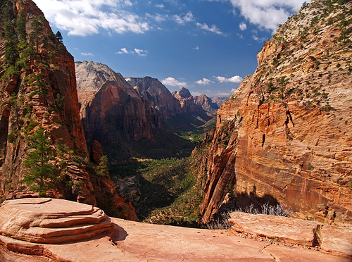
Angel's
Landing
Angels Landing is a 1763m high rock formation accessed via a
strenuous and partially exposed 8km trail over 450m of elevation gain.
The path is extremely narrow in parts, but secured with chains, and
offers spectacular views.
Emerald Pools
The Emerald Pools can
be reached via the trail of the same name. This hiking trail, which runs
through dense forests, is a popular day hike. The Emerald Pools are
created by temporarily flowing rivers, the water from which seeps into
the porous Navajo sandstone that can be found throughout the park,
collects somewhere again into small streams and then emerges from the
rock face. In the case of the Emerald Pools, this takes the form of
small waterfalls. Their water flows into a series of circular rock pools
called the Emerald Pools. They got their name because of their emerald
color.
The Narrows
The Narrows are at the end of Zion Canyon.
From the shuttle's final stop, Temple of Sinawava, it's a 30- to
40-minute walk to this gorge on the Virgin River. Here you walk through
the river itself, since the steep walls do not allow a path along the
bank at this point. The water is more than waist deep in places, so you
have to swim in places. At the end of the narrows is Chamberlain Ranch.
One to two days should be planned for the hike through. The 25km walk
through the river is very strenuous as most of it is in the river
itself. The walk-through must be registered at the visitor center at the
backcountry desk. In the spring, no permission is granted because of the
snowmelt and the associated water level. Even in summer, flash floods
can occur due to violent thunderstorms. The thunderstorms do not have to
come down in the park itself; the water may also come from the Colorado
Plateau.
Kolob Arch
Depending on the measurement, the Kolob
Arch shares the attribute “longest natural stone arch” with the
Landscape Arch in Arches National Park. The mean value of the last
measurements of the Kolob Arch is 89.6 m and thus exceeds the Landscape
Arch by 1.2 m.
The Kolob Arch can only be reached via two hiking
trails (22 km and 27 km in length). The arch itself sits right in front
of a large, sheer cliff, so its view isn't as spectacular as other
free-standing arches. A second natural rock arch is the Crawford Arch.
Checkerboard Mesa
At the park's east entrance is the Checkerboard
Mesa, a mesa formed of Navajo Sandstone. Deep vertical grooves and
chimneys and horizontal bands cut through the mountain's flanks. The
bands form along the layer boundaries through weathering and erosion
along different sedimentation layers. The vertical troughs can only be
observed on the north side, since the snow melts more slowly here and
they are widened by running water and frost erosion.