Location: Page, Arizona Map
Depth: 120 feet (37 meters)
Antelope Canyon belongs to the so-called slot canyons. It was formed by the erosion of Navaja sandstone. Geologists call the causes of erosion, firstly, sudden floods, and secondly, subaerial processes. Rainwater, especially during the monsoon season, enters the vast pool above the sections of the slot canyon and picks up speed and mixes with the sand into the narrow passages of the canyon. For a long time, the passages in the rock were destroyed, becoming deeper and smoothing out, acquiring characteristic "smooth" forms. Today, floods in the canyon occur more and more often. The most recent flood occurred on October 30, 2006 and lasted 36 hours, forcing the park authorities to close Lower Antelope Canyon for 5 months.
Antelope Canyon is a popular destination for
photographers and tourists, as well as a source of business tourism
primarily for the Navajo Indians. The pass to Indian territory, to
Antelope Canyon, has been open only since 1997, when the Navajo tribe
made their territory a restricted tribal park. Photography within
canyons is difficult to create due to the wide range of brightness
(often 10 EV or more) made easy by the reflection of the canyon walls.
The colors seen in the photographs do not always fully correspond to
what the living human eye sees in Antelope Canyon. This is a strange
place, the photos of which can look even more beautiful and mysterious
than reality. The blue tones of deep shadows appear only in the
pictures, apparently the human brain filters out this blue when looking
at the canyon at dusk. You need to be prepared for the fact that you
will have to shoot with shutter speeds of several tens of seconds or
more to obtain a large depth of field. When photographing using
bracketing, shooting takes place in different modes, which helps to hide
exposure meter errors. Due to the constant use of tripod bracketing, you
can get several shots with different worked areas of the same angle,
which allows you to combine images in a raster graphics editor when
processed on a computer and get amazing results. Pictures taken in
Antelope Canyon are especially attractive to the viewer. The best time
to take pictures is in the middle of the day when the sun is at its
zenith. For the Lower Canyon, the best time is before noon and
immediately after (from 10 am to 11 am or from 1 pm to 2 pm), and for
the Upper Canyon, the best time around noon is from 11 am to 1 pm. This
is due to the fact that the Upper Canyon is deeper and the light
penetrates there less, and in the Lower Canyon at noon there is too much
direct light and the magic disappears.
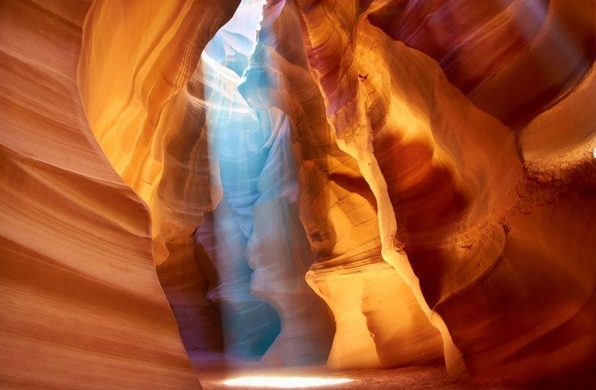
The Upper Canyon is about 200 m long and 37 m deep.
Named by the Navajo tribe Tse bighanilini, "The place where water runs
through the rocks," it is most frequently visited by tourists because of
two features. The first is that the entrance and the entire length of
this part of the canyon are at ground level and do not require climbing.
The second, rays (direct sunlight coming from holes at the top of the
canyon) are much easier to see here in the Upper Canyon than in the
Lower. Rays are more often observed in summer, since this requires the
Sun to be as high as possible in the sky.
Upper Antelope Canyon
is very beautiful. In winter, the colors are a little more muted. During
the summer months, two types of lighting are available for taking
photographs. Deep reds, blues and purples can be obtained during morning
and mid-afternoon tours. Rays of light begin to penetrate the canyon
from March 15th and disappear by October 7th. The period of greatest
illumination lasts from May to September.
The Lower Antelope Canyon, called the Hasdeztwazi, or
"Spiral Arches of Rock" by the Navajo tribe, lies a few kilometers
beyond the Upper Canyon. Its length is 407 m. Before the installation of
metal ladders, visiting the canyon had to climb and descend on ropes and
very dangerous rope ladders in certain areas. Even after the ladders
were installed, the Lower Antelope Canyon hike was significantly more
difficult than the Upper Antelope Canyon hike—the route is longer,
narrower in places, and in some places you can't even stand on your
feet. At the end of the route you need to climb several long flights of
stairs.
Despite these limitations and the equally astonishing
terrain of the Upper Canyon, the Lower Antelope Canyon is a much
stronger attraction for photographers who want to capture it on film.
Lighting here is best in the early hours of the morning or late in the
afternoon.
Antelope Canyon can only be visited with a guide,
because during the rainy season there is a danger of rapid flooding.
During a thunderstorm or even with slight signs of its occurrence, it is
strictly forbidden to go down into the canyon - the probability of a
sudden flood is too high. On August 12, 1997, 12 tourists were washed
away in the Lower Canyon, 11 of whom died.
Antelope Canyon in
culture
Britney Spears has released a music video for her 2001 song
"I'm Not a Girl, Not Yet a Woman". The clip takes place in the Upper
Antelope Canyon.
Episodes of some films also show Antelope Canyon, in
particular the Upper Canyon. Among such films is the 1996 film Broken
Arrow starring Christian Slater and John Travolta.
Antelope Canyon is a "slot canyon", a narrow chasm
in erosions in sandstone. Years of water and sand has rounded the
edges to form curves and flowing shapes in the rock. Photographers
love the beauty and unique shapes and lighting conditions of the
canyons. Flash flooding still occurs in the canyon and may, at
times, result in up to several months of closing. Since 1997 the
area has been accessible only by permit as it is now a Navajo Tribal
Park.
Entrance Station Hours, Coppermine Rd. (Navajo Route
20). Summer (March-Oct) 8AM-5PM. Station is closed Nov - Feb, but
Lower and Upper Antelope Canyon are both open. Office Hours M-F
8AM-5PM. Entry Fees: Adults $6; under 8: free. No camping is allowed
in the park. Access is by guided tour only.
Antelope Canyon Park
Office, ☎ +1 928 698-2808, fax: +1 928 698-3360, e-mail:
ac@navajonationparks.org. The office is located three miles south of
Page, Information and permits can be obtained for Water Holes Canyon
and the Rainbow Bridge trails.
Navajo Village Heritage Center,
1253 Coppermine Rd, ☎ +1 928 660-0304.