Location: 10 mi (6 km) East of Torrey Map
Area: 241,904 acres (97,895 ha)
Info: (435) 425 3791
Open: Jun- Sept: 8am- 6pm daily
Oct- May: 8am- 4:30pm daily
Area: 241,904 acres
When to go: spring- fall
Activities:
camping, hiking, mountain biking
To see:
- Rim Overlook
trail
- hike to Sunset point
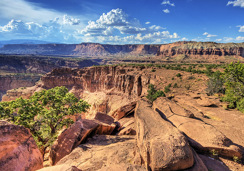
Capitol Reef National Park is an American national
park located in central Utah. With an area close to 979 km2, the
park is famous for its geological formations composed of colored
rocks that are tens of millions of years old. The park consists of
elevated and semi-arid areas, several natural arches, and is
characterized by significant monocline folding of the earth's crust
partly exposed by erosion. The name Capitol Reef (literally "Capitol
Reef") comes from the monumental shape of certain rocks from an
ancient coral reef present there several million years ago, when the
area was covered by a sea.
The natural environment is
essentially characterized by many animal and plant species that can
withstand a semi-arid climate. Nevertheless, wetter areas near
rivers and at higher altitudes are also colonized by species more
adapted to these environments.
The surrounding regions of the
park were inhabited by Native American peoples of the Fremont
culture between the 7th and 17th centuries, then by Paiute and Ute
Native Americans who limited their activities there to hunting and
gathering. The first European explorers arrived in southern Utah at
the end of the 18th century and the first settlers, Mormons, settled
there after 1875.
On December 18, 1971, Capitol Reef became a
national park. National Park Service staff members have since been
on a mission to protect geological, natural and cultural riches
while welcoming and educating the hundreds of thousands of tourists
who visit the park each year.
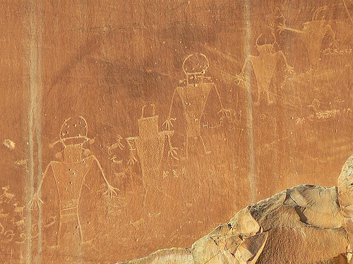
The area was inhabited by Native Americans of the
Fremont culture from the 7th to 16th centuries. This tribe takes its
name from the eponymous river which crosses the region where their first
vestiges are discovered. Living in semi-troglodyte dwellings, the social
structure consists of only a few families. They live by gathering and
hunting but improve their diet by growing maize, squash and tepary beans
not far from the river. Among the edible foods of the region are pine
nuts, seeds of the grass Stipa hymenoides, berries, bulbs and tubers.
Corn is ground into flour on a flat stone using another portable stone.
Game (deer, rabbits, birds) is hunted with atlatls, arrow bows or
snares. The fish were caught with nets.
They made shoes using
local plant fibers from Yucca, among others, but also moccasins using
the skin of the legs of game. They made clay pottery.
They make
pictographs and petroglyphs on rocks to represent their way of life.
These works also depict animals like deer, birds, lizards and snakes.
Archaeologists have no certainty to explain the disappearance of the
Frémonts in the region. Some believe that they immigrate to other
regions following, for example, changes in climatic conditions.
Subsequently, the region is traveled by nomadic peoples. When the first
Europeans arrived, the nomadic Amerindians discovered in the region
belonged to the Paiute and Ute tribes.
European colonization of the region only began after
1875. It was at this time that Mormons settled there to practice
agriculture by taking advantage of the water of the Fremont River. The
first locality is named Junction because it is located at the junction
of the Fremont and Sulfur Creek streams. Although the area suffered
various floods, orchards of fruit trees were planted and the Mormons
managed to live from their work. In 1902, the locality was renamed
Fruita but its population never exceeded ten families.
Ephraim
Portman Pectol, a Mormon living near Capitol Reef helped create the
protected area. Fascinated by the landscapes of the place and hunter of
objects of the Frémont culture, he promotes the region with the help of
his brother-in-law Joseph S. Hickman. Pectol was elected to the
government of Utah in 1933 and quickly contacted President Franklin
Delano Roosevelt to support his request to make the region a national
monument.
On August 2, 1937, the President granted an area of
152.6 km2 national monument status as Wayne Wonderland National
Monument. In 1943, the national monument was guarded by a single person
working as a volunteer for the National Park Service. It was only after
1950 that this guard received his first salary. In 1958, the National
Park Service dispatched a second person from Zion National Park. This
year, the monument welcomes nearly 56,000 visitors.
The National
Park Service decided to buy back the lands of the various Mormon owners
located inside the protected area at the end of the 1960s. Since then,
only a few buildings have been maintained in order to preserve the
history of the region. The orchards, which include approximately 2,600
trees, are also still maintained by park staff. They are home to many
fruit trees including apple, cherry, plum, pear, peach, apricot and
walnut trees. These fruits can be picked by visitors who must pay for
their harvest when leaving the orchards. It was not until the 1960s that
a reception center and a camp were built for visitors. In 1967, the park
welcomed 146,598 visitors and the staff grew. In 1968, 870.3 km2 were
added to the monument. The area was granted national park status on
December 18, 1971 under President Richard Nixon's legislature.
The nearest international airport is located in Las Vegas, more than 500 km away. Other major international airports in the region are located in Salt Lake City and Denver. There is no public transport to the park and the road is therefore the only way to get there. The park is accessible from the Interstate 15 (which connects Salt Lake City to Las Vegas) or Interstate 70 (which connects Denver to Interstate 15) expressways thanks to the Utah State Route 24 which crosses it from east to west. It is also possible to reach Bryce Canyon National Park via the Utah State Route 12 tourist route which begins just east of the park.
Fremont River & Scenic Drive
Burr Trail Road
Cathedral Valley Loop
Hickman Bridge Trail
Located in central Utah, the park spans the counties of Wayne, Garfield, Emery, and Sevier. The nearest metropolises are Las Vegas over 500 km to the southwest, Salt Lake City over 500 km to the northwest, and Denver over 600 km to the northeast. Despite its isolation, the park is however easily accessible from Interstate 15 and Interstate 70. With a total area of 978.95 km2, the park stretches approximately 110 km from north to south, while its width varies between 2 and 20 km from east to west. Its name, which could be translated as "Capitol Reef", comes from a very rugged place within the Waterpocket Fold and whose monumental shape recalls a capitol which would have been built in rocks from ancient fossilized reefs.
The highest point in the park reaches 2,516 meters at
Cathedral Valley while the low point does not exceed 1,209 meters in
elevation south of the park along Halls Creek.
The whole region
belongs to the western part of the Colorado Plateau, famous for its
reddish rocks subject to erosion present in all the national parks in
the vicinity. Capitol Reef is located more precisely below the eastern
border of the Aquarius sub-plateau which rises to 3,449 meters at
Boulder Mountain.
The region is at the limit of humid continental Dfb
type and semi-arid Bsk type climates according to the Köppen
classification. The climate has fairly cold winters and relatively hot
summers. The minimum temperature record is −27°C, while the maximum
temperature record is 36°C. Frosts can occur for much of the year
although these are usually absent from April to October.
Rainfall
is low in the park. The humidity coming mainly from the Pacific Ocean is
stopped at the level of the Sierra Nevada mountain range located further
west. The low-lying areas between the Sierra Nevada and the park, which
are part of the Great Basin, exhibit shelter desert conditions. Thanks
to a higher elevation, the park receives slightly more precipitation
than the low desert plains, but it's still less than areas at even
higher elevations, such as nearby Bryce Canyon National Park. June is
the least rainy month, while August is the wettest. Summer is indeed
marked by the North American monsoon present in the desert regions of
the central United States and which differs from the Asian phenomenon of
the same name. The rains are much less abundant but are regular in the
afternoons during the month of August. Small canyons can thus be flooded
very quickly by intense mudslides. Due to low temperatures, part of the
precipitation can take the form of snow in winter.
The entire park belongs to the Colorado River watershed. Streams in the northern part of the park flow into the Fremont River which runs through the park from west to east before joining the Dirty Devil River, a tributary of the Colorado River. To the south of the park flows the Halls Creek whose waters also join the Colorado River at the level of a canyon occupied by Lake Powell. The latter, which has its source in the Rocky Mountains, flows in a southwesterly direction to end its course in the Gulf of California in Mexico, after traveling nearly 2,250 km. The numerous water pockets (English: Waterpocket) carved into the rocks and scattered throughout the park gave their name to the Waterpocket Fold.
The geological history of Capitol Reef is
characterized by numerous sedimentary deposits that date from the
Permian (270 million years) to the Cretaceous (80 million years). The
study of the rocks indicates that the region is then successively
covered by seas, marshes or deserts.
During the Permian, Utah was
located at the bottom of a warm sea located near the equator.
Subsequently, due to the drift of the North American tectonic plate, the
region moves northward and its climate becomes tropical. The region is
at this time covered by marshes where trees grow in a hot and humid
climate. The North American plate continues its course towards the north
and the environment becomes more and more arid. The region is then
covered by large deserts. It is the sand deposits of this period that
are for example at the origin of the Navajo sandstone whose reddish
color symbolizes the geological landscapes of the region. It is in these
rocks, among other things, that the natural arches visible throughout
Utah have been formed. Subsequently, the region sinks and is covered by
a huge channel nicknamed "Western Interior Seaway" where new sedimentary
deposits accumulate.
The geology of the region is finally
characterized by the formation of a folding of the earth's crust over
nearly 160 km, which is called the Waterpocket Fold. This folding
appears between 70 and 50 million years ago during the uplift of the
entire region during the Laramian orogeny. Rocks from previously
deposited sediments are exposed, deformed and partly eroded over time.
Among the geological treasures visible in the park is the Cathedral
Valley (literally “Cathedral Valley”). Located in the northwest of the
park, it takes its name from imposing blocks of red and white rocks
whose shapes are reminiscent of cathedrals built by man.
The national park is located west of the Colorado Plateau, bordering the cold deserts of North America and the Western Cordillera of the Northwest Wooded Mountains which form two distinct ecoregions according to the Environmental Protection Agency. environment of the United States, and more specifically the more humid Colorado Plateaus and the Wasatch and Uinta Mountains, which allows for greener and taller flora. WWF's ecoregions are larger and less specific: it locates the park in the Colorado Scrub Plateau ecoregion. The park hosts more than 900 species of plants and more than 300 species of vertebrates
Among the trees present in the park are the trembling
aspen (Populus tremuloides), the ponderosa pine (Pinus ponderosa), the
alder-leaved serviceberry (Amelanchier alnifolia) and its edible
berries, but also the gabled pine ( Pinus edulis) and Utah Juniper
(Juniperus osteosperma).
Grasses are common with the grazing
tussock (Bouteloua gracilis), the membranous tussock (Stipa hymenoides)
and Hilaria jamesii. The bushes are represented by Dense Orache
(Atriplex confertifolia), Big Mugwort (Artemisia tridentata), Stinking
Rabbitbrush (Chrysothamnus nauseosus) and Vermiculated Sarcobatus
(Sarcobatus vermiculatus). Some plants belong to endangered species like
Cymopterus beckii and Schoenocrambe barnebyi. The park also protects a
third of the known plants of the species Sclerocactus wrightiae, a
quarter of Gilia caespitosa, half of Erigeron maguirei and all of
Astragalus harrisonii.
The mammals are represented by the Hemione Deer
(Odocoileus hemionus), the Black Bear (Ursus americanus), the Puma (Puma
concolor), the American Gray Fox (Urocyon cinereoargenteus), the
Canadian Beaver (Castor canadensis), the Pig -American porcupine
(Erethizon dorsatum), Botta's gopher (Thomomys bottae) but also the
desert shrew (Notiosorex crawfordi), the pygmy bat (Myotis leibii), the
blond bat (Antrozous pallidus), the Cunning Bassaris (Bassariscus
astutus), Stoat (Mustela erminea), Mexican Spotted Skunk (Spilogale
putorius), Yellow-bellied Marmot (Marmota flaviventris), Golden Ground
Squirrel (Citellus lateralis), Colorado Chipmunk ( Tamias
quadrivittatus), Ord's Kangaroo Rat (Dipodomys ordii), Townsend's Hare
(Lepus townsendi) and Desert Neotoma (Neotoma lepida). The Utah Prairie
Dog (Cynomys parvidens), which is present in the park, belongs to the
list of endangered species.
Many birds are permanent residents of
the national park area while others are just passing through during
their migration. The most common birds in the park are the American
Kestrel (Falco sparverius), Chukar Partridge (Alectoris chukar),
Mourning Dove (Zenaida macroura), White-throated Swift (Aeronautes
saxatalis), Black-throated Hummingbird ( Archilochus alexandri),
Broad-tailed Hummingbird (Selasphorus platycercus), Rufous Hummingbird
(Selasphorus rufus), Northern Flicker (Colaptes auratus), Red-naped
Woodpecker (Sphyrapicus nuchalis), Western Kingbird (Tyrannus
verticalis) , Canyon Wren (Catherpes mexicanus), Horned Lark (Eremophila
alpestris), Rough-winged Swallow (Stelgidopteryx serripennis), Pinewood
Jay (Gymnorhinus cyanocephalus), Juniper Tit (Baeolophus ridgwayi),
Blue-grey Gnatcatcher (Polioptila caerulea), American Robin (Turdus
migratorius), Yellow-rumped Warbler (Dendroica coronata), Baltimore
Oriole (Icterus galbula) and Red-winged Blackbird (Agelaius phoeniceus).
The national park is home to a few species of amphibians including
the Tiger Salamander (Ambystoma tigrinum), the Great Basin Toad
(Scaphiopus intermontanus), the Western Pied-en-bêche (Spea hammondii),
the Boreal Toad (Bufo boreas), the Toad Woodhouse's Toad (Anaxyrus
woodhousii), Spotted Toad (Bufo punctatus), Western Chorus Frog
(Pseudacris triseriata) and Northern Leopard Frog (Rana pipiens).
Reptiles are represented by Cnemidophorus tigris, Sceloporus
undulatus, Spotted-sided Lizard (Uta stansburiana), Sagebrush Lizard
(Sceloporus graciosus) and Chuckwalla Sauromalus obesus. The most common
snakes in the park are the Gopher Snake (Pituophis catenifer) and
Masticophis taeniatus. Among the venomous snakes is the Western
Rattlesnake (Crotalus oreganus).
The fish present in the
waterways of the park are brown trout (Salmo trutta), rainbow trout
(Salmo gairdneri), cutthroat trout (Salmo clarkii), brook trout
(Salvelinus fontinalis), Speckled Dace (Rhinichthys osculus), Utah
Shiner (Gila atraria), Pink Shiner (Richardsonius balteatus), Common
Catfish (Ictalurus melas), Bluegill Sunfish (Lepomis macrochirus),
Mottled Sculpin (Cottus bairdi ) and Catostomus latipinnis (Catostomus
latipinnis).
The national park is administered by the National Park
Service, which depends on the United States Department of the Interior.
This national service has a total annual budget of 2.361 billion dollars
(2005) and must manage at the national level several protected areas
whose total area is around 340,000 km2.
The role of the national
park service is to preserve and protect natural and cultural resources.
The United States Congress conferred on it the title of federal agency
upon ratification of the National Park Service Organic Act on August 25,
1916. According to this law, the mission of the service is to promote
and regulate the use of national parks protecting landscapes, wildlife
and historic sites to leave them intact for future generations. Hunting,
mining and logging, and the collection of natural and cultural resources
are illegal in the park. The exploration and exploitation of petroleum
or natural gas is also prohibited.
Each year, the park welcomes
nearly 1,200,000 visitors despite its limited accessibility due to its
distance from major urban centers. It is managed by nearly 50 National
Park Service officers whose job is to welcome visitors and protect the
natural environment. The natural environment is also protected, in
particular by monitoring and destroying undesirable non-native plants,
but also by maintaining the orchards. Awareness sessions on the wealth
of the park are also offered to visitors as well as to many schools.
The park, famous for its colorful landscapes, attracts nearly 1,200,000 tourists every year. Attendance is lower than national parks in the region, which can be explained by its greater distance from major cities and highways. For example, the Grand Canyon receives over six million visitors, Zion over four million, and Bryce Canyon over two million. The park, accessible only by road, is open throughout the year, as are its infrastructures, with the exception of certain public holidays.
In the park, accommodation is only possible at a few
campsites. On the other hand, hotels are present outside the park in the
small neighboring towns whose economy depends in part on Capitol Reef
tourism.
Park rangers inform and guide tourists who wish. It is
thus possible to visit some old dwellings occupied by the Mormons at the
Fruita orchards. During the harvest season, visitors can harvest fruit
themselves for a fee. Visitors to the park can also indulge in rock
climbing, biking, fishing, and horseback riding.
The park has
many hiking trails classified according to the difficulty according to
their lengths and the difference in altitude to be crossed. Among the
easy ones, the Capitol Gorge (2 km) allows you to see pockets of water
within a canyon while the Fremont River (2 km) allows you to visit the
orchards. The trail leading to the Hickman Natural Bridge is of medium
difficulty (1.6 km), not for its length but for the steepness of the
drop that leads to the eponymous natural arch. The most difficult
trails, such as the one leading to Cassidys Arch and the Navajo Knobs,
have lengths of more than 2 km and elevation differences between 200 and
500 m.
The park is very often only one stage among others for tourists. Southern Utah and Northern Arizona have many tourist attractions. In this region are the northern part of Grand Canyon National Park, Zion National Park, Bryce Canyon National Park, Canyonlands National Park and Arches National Park. The American tourist route Utah State Route 12 which connects Bryce Canyon to Capitol Reef is an attraction in itself. Nature is present throughout this sparsely populated region, including the sprawling Dixie National Forest. The Lake Powell area and its Glen Canyon National Recreation Area offers many recreational opportunities. In addition to national parks, the Capitol Reef area is home to many national landmarks like the Grand Staircase-Escalante, Cedar Breaks, Rainbow Bridge, and Vermilion Cliffs. All these places have been recognized as being of national interest for their specific natural landscapes, their archaeological, geological or paleontological riches.