Location: Santa Cruz Department Map
Area: 4,425 km² (1,709 sq mi)
Amboró Hotel
Tel. 591 (0) 9322054
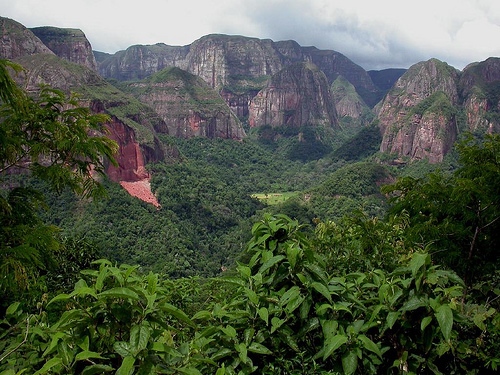
Amboró National Park is locate in Santa Cruz Department in Bolivia. Amboró National Park covers an area of 4,425 km² (1,709 sq mi). The elevation of the biosphere reserve ranges from 300 m to 3200 m above sea level. The average temperature in Amboró National Park is inversely proportional. It ranges from 12 C to 24C annually. There are over 700 species of birds that live in their niches at different elevation and different place in the park. The park lies just off the highway from Cochahamba to Santa Cruz. The closest hotel to the Amboró National Park is Amboró Hotel in Buena Vista.
Location: it is located in the department of Santa Cruz, Bolivia,
bordering the department of Cochabamba in the west.
Protect the
areas of great biodiversity representative of the Biogeographical
Province of Yungas, its ecosystems, genetic resources and endangered
and typical endangered flora and fauna.
Protect the
geomorphological formations and unique landscapes of the sub-Andean
mountains.
Protect the river basins, especially their headwaters,
considering the high rainfall that the area receives and the
topography characterized by steep slopes.
Contribute to local and
regional development through ecotourism, nature recreation,
interpretation and environmental education activities.
Promote
scientific research, particularly that which contributes to
improving the management of the Area and natural resources within
the framework of current legislation.
Promote the monitoring of
ecological processes.
Objectives of the Natural Area of
Integrated Management
Rational and sustainable use of
natural resources by the populations that inhabit the ANMI, with a
view to obtaining improvements in the quality of life through the
benefits derived from the conservation and management of the Area.
Protect watersheds.
Protect soils subject to agricultural or
agroforestry use, especially through traditional practices or
appropriate new technologies.
Promote the recovery of natural
vegetation and soils affected by erosive processes, in order to
improve the quality of existing ecosystems.
Contribute to the
protection of cultural heritage and the rescue of traditional
techniques and systems of resource use of local inhabitants.
Promote productive activities that are framed in sustainable
development policies and that prove to be experiences that are not
attentive to ecosystems and their processes.
Provide
opportunities for recreation in nature, ecotourism, interpretation
and environmental education.
Provide opportunities for scientific
research applied to the use and protection of natural resources and
environmental monitoring towards productive and recovery activities.
History
The beginnings of the Amboro National Park date from
the early 1970s, when a section of the Amboro Hill was declared
"Tcnl. German Busch Nature Reserve" in 1973.
Subsequently, in
1984 the protected area is reassigned as Amboro National Park with
an area of 180,000 ha. Subsequent expansions and readjustments
caused an expansion of the protected area to 442,500 ha, surrounded
by the Integrated Management Area.
Ecoregions
The main
ecoregions covered by the protected area are the Mountainous Wet
Forest of Yungas, Chaco, Dry Mountain Forests and the Cloud Forests.
On the other hand, the Park Management Plan (FAN-TNC 1997) the
following regions:
Seasonal evergreen wet forest. Formation
of alluvial origin, the topography is almost flat and the soils
constituted by recent sediments of quaternary materials.
Wet
forest at the foot of the mountain. The topography is undulating,
forming some very low mountain hills of narrow aspect and narrow
valleys.
Sub-Andean Rainforest Topographic variations are
somewhat complex due to the marked inclination, being a transition
zone between the plain and the mountains. The soils have good
drainage.
Mountainous wet forest of Yungas. It has steep slopes,
relatively wide alluvial valleys and deep gorges. It is the best
represented area within the park.
Yunga eyebrow. Located in an
area of slopes, peaks and ridges of steep slope and deep gorges;
It occupies only a minimal portion of the area in some mountainous
edges exposed to clouds between 3000 and 3100 meters above sea
level.
Dry Interandine Valleys. With partially flat topography
and soils of quaternary material of colluvial and fluvio-lacustrine
origin. They are located in the southern part of the area.
Flora
The area is characterized by having a great floristic
diversity worldwide. There are approximately 3,000 species of plants
registered for the area. Among the great diversity are numerous
species of orchids, the giant tree ferns (Cyathea and Alsophyla)
that form extensive patches. As well as economically important
species such as the pacay (Inga velutina), the asaí (Euterpe
precatoria) and the guitarist (Didymopanax morototoni). As well as
timber species such as the mara or American mahogany (Swietenia
macrophylla), the mountain pine (Podocarpus spp.) And the walnut
(Bolivian Juglans).
Wildlife
In the Park there are more than 177 species of
mammals, among which the 43 species of bats stand out. Among the
large mammals we find the Andean bear or jucumari, the jaguar or
American tiger, the flag bear (anthill), among others. There is a
high level of endemism in the park, 135 species of reptiles and 173
species of amphibians among which 50 species are toads. There are
912 species of birds, the birds that arouse most interest are the
tuft turkey, and the military stop. Many endemic and dawned bird
species survive in the park in other regions.
Genetic
resources
The area constitutes a natural reservoir of a great
diversity of wild genetic resources typical of tropical ecosystems.
And of species of economic importance such as fine woods that are in
the process of commercial extinction.
Archeology
To the
south of the protected area, in the area of influence, are the
pre-Columbian ruins of the Fort of Samaipata and the Tunal
pictography.