Location: Oruro Department Map
Area: 1,002 km²
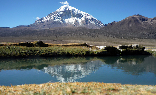
Sajama National Park is located in Oruro Department in Bolivia. This national park covers an area of 1,002 km². Sajama National Park was added to the UNESCO World Heritage Tentative list in 2003. This is one of the highest national parks in the country and all of the World. Its highest peak of Nevada Sajama reaches a height of 6,542 meters (21, 463 ft). Needless to say altitude sickness and low temperatures are two common dangers that might haunt tourists who will venture in this land. Precautions should be taken. Additionally Sajama National Park is inhabited by the Aymara native tribes. These people managed to preserve harmony with the surrounding environment and still inhabit their historic land.
Weather
The climate of the area is characterized by being
semi-arid and cold, the average annual temperatures are around
4.6º C (maximum 6.9º C and minimum 1.0º C). Temperatures at
night are below 0 ° C. The annual rainfall is 321.1 mm, with
monodomal distribution, January being the wettest month. In
addition, the area is characterized by receiving high levels of
solar radiation throughout the year due to low cloudiness and
high elevation. The temperature at ground level undergoes
drastic fluctuations between day and night.
Atmospheric
pressure
From December to February and partially March, the
advection of moisture and convective winds in the afternoon
produce cloud formation, reducing radiation reception. There are
clear differences in the amount of solar radiation received in
the dry and wet season. In the wet season the average radiation
levels are 1200 wm.-2 and in the dry season, 800 wm.-2.
On the other hand, during the transition period between the wet
and dry season (October to November) the highest values of
solar radiation are recorded. The climax occurs at noon, unlike
morning and afternoon because the atmosphere is covered with
convective clouds (Hardy et al. 1998). On the other hand, during
the wet season (December to February until March) the radiation
levels decrease due to the advection of humidity and the
convection of clouds during the afternoon, which cover the high
plateau and prevent the sun's rays from reaching the surface of
the earth. The greatest amount of radiation is recorded at noon,
this decrease during the afternoon due to the presence of
clouds. Finally, in the dry season (May to June) the cloud cover
is reduced and occasionally cold fronts arrive that carry
precipitation and snowfall.
Temperature
The Sajama is
influenced by the tropical climate, but due to its southern edge
of the tropics, extra-tropical currents also influence during
the dry season. A low temperature variation is observed during
the year, this generally follows the annual radiation cycle. The
average temperature is 4.6 ° C and the minimum temperatures
recorded in January are -7.5 ° C and in June -14.1 ° C. The
thermal variation can reach +/- 8 ° C during the day
(Liberman-Cruz 1986, Braun 1997, Hardy et al. 1998).
The
ambient temperature is influenced by the solar radiation
received, in January the average temperature is 7.5 ° C and in
June, -14.1 ° C. The thermal amplitude during the day is greater
than the annual thermal amplitude because the Sajama is at a low
latitude and high elevation (Liberman-Cruz 1986, Vuille et al.
2001).
Humidity
The variation in Relative Humidity is
marked during the year, between 0.2% to 99.9% during the year.
During the wet season (December-February) the relative humidity
is 90% and the specific humidity is 3.6 g Kg.-1. High humidity
values are associated with east winds that transport moisture
from the Amazon (Hardy et al. 1998, Vuille et al. 2001).
During the dry season (May-July) the humidity can drop up to 20%
for several days. The specific humidity values reach up to
0.99 g Kg.-1. Extremely dry periods are interrupted by short
periods of high humidity, produced by humid episodes related to
polar air masses that reach the Altiplano (Hardy et al. 1998).
Wind speed and direction
Wind speed changes significantly
in mid-May, winds accelerate unexpectedly and remain for most of
the time. The average wind speed from May to October is 20 m / s
and in December to February, 2.6 m / s, decreasing in the
afternoon hours.
During the dry season the wind blow
north to the northeast. Winds can reach high speeds and are
generally associated with dry conditions. While during the wet
season, the wind runs south to east. Winds from the east provide
moisture that influences precipitation. In the month of April
there is an inversion of the wind direction, from north to
northeast, which remains until August (Liberman 1986, Hardy et
al. 1998).
Hydrology
The rivers that drain the area belong mainly to the
Lauca river basin, which belongs to the Coipasa salt flats
basin. A small sector to the north belongs to the Blanco river
basin, tributary of the Desaguadero river. Both basins are part
of the Endorheic Basin of the Altiplano. The most important
rivers are Sajama and Tomarapi. But for characterization
purposes the area was divided into four Sajama, Tomarapi,
Esquillani and Blanco basins. Although there is no detailed
study of the glaciers of the snowy Sajama and the Nevados de
Payachatas, these provide important tributaries to the Sajama,
Tomarapi and Esquillani basins. The volume of water stored in
the glaciers is unknown although an estimate of 113 m depth of
the glacier for the summit of Sajama has been made. Another
important component of the hydrography of the area is the
lagoons of the puna and the high mountain areas. Highlighting
the Huaña Kota lagoon north of the town of Sajama for being an
important source of water for community members and wildlife and
as a refuge for birds.