Location: 140 km south of Cochabamba, Northern Potosí Department Map
Area: 165 km²
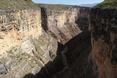
Torotoro National Park is located 140 km south of Cochabamba in Northern Potosí Department in Bolivia. Torotoro National Park covers an area of 165 km² along Eastern border of the Andes mountain chain. There is not much infrastructure in Torotoro National Park and there is no asphalt road. So basically it is open to people who are on the suicidal side. It would take you at least 7 hours to travel here, but it will worth the ride. Avoid traveling in the rainy season because that might make reaching this Bolivian natural reserve impossible. With no noisy crowds, this land will offer pretty much anything you want to see. Its central geological feature is a canyon that reaches a depth of 300 meters. This seemingly barren semi- arid land was once home to thousands of dinosaurs that once roamed this area. Over 2,500 different tracks were discovered from different species and different time periods.
One of the most visited sites in National Park is cave Humajalanta (Cueva Humajalanta). It stretches for 4.5 km and reaches depth of up to 160 meters. It doesn't have much safety measures and you would have to crawl, climb and walk using your own strength. It has only few ladders and ropes that might help in exploration of the cave. It is highly advisable to take a local guide if you don't want to risk remaining here forever. Additionally Torotoro National park also contains Llama Chaqui archeological site that belonged to Quechua natives.
On June 10, 1988, Rodolfo Becerra de la Roca from Toro Toro founded
the Torotoro Conservation Association (ACT), with the aim of promoting
the conservation, protection and proper management of wild flora and
fauna, paleontological and speleological resources and natural beauty of
the Toro Toro area. The ACT carried out the Study for the Creation of
the Torotoro National Park (PNT), based on which it managed its
declaration by Supreme Decree No. 22269 of July 26, 1989. This was
elevated to the rank of law by No. 1370 of November 13, 1992, during the
government of Jaime Paz Zamora. Thus, Toro Toro became the only national
park in Bolivia that has been established by private initiative, and
that is why Becerra de la Roca is considered the founder of this
national park.
In 2019, the Institute for Responsible Tourism
(ITR), an entity belonging to UNESCO, awarded the Toro Toro National
Park the international "Biosphere" tourism certification, being the
first tourist destination in Bolivia to obtain this certification. This
certificate verifies that it is a sustainable tourist destination at an
economic, environmental and cultural level.
Some members of the
UNESCO World Geoparks Council visited the Toro Toro National Park in
November 2021 with the aim of potentially nominating the park as a
geopark, which would make it the first in Bolivia and the ninth in Latin
America. It is estimated that a final response on the designation will
be available by January 2022.
It is located in the province of
Charcas to the north of the department of Potosí, 140 km from the city
of Cochabamba from where access is made due to its greater proximity. On
the way, it passes through the towns of Cliza, Anzaldo, Toco and El
Caine River, with a significant flow in the rainy season, access is
difficult at this time. Another access route is the route from the city
of Oruro, which includes the towns of Bolívar, Sacaca, and San Pedro de
Buena Vista.
The park occupies the region of the mesothermal dry
valleys to the north of the department of Potosí. The region is
typically mountainous with deep canyons, valleys, and waterfalls.
329 species of flora were recorded and the existence of 600 species of higher plants is estimated. Typical species of the deciduous forest stand out, such as the white quebracho, soto and the mountain pine. In the high parts there are remains of queñua thickets. 49 species of fauna have been registered, highlighting the taruca or Andean deer, Andean cat or titi, puma, the endemic red-fronted macaw, parrot, endemic thrush in the region.
The national park is located in the northern Potosí department around the town of Torotoro, 140 km south of Cochabamba. Until 2021 it could only be reached via gravel roads and river beds. Since then there has been a new connection that reduces the journey time to 3 hours. The Torotoro National Park is located in a semi-arid landscape at an altitude between 3500 and 2000 m, with extensive karst caves, such as the cave of Umajalanta (alternative spelling Humajalanta), and canyons that are cut up to 300 m deep. Dinosaur footprints can also be seen within the park. Guided tours can be booked at the National Park Office.
Geology and paleontology
It is a true paradise for lovers of
geology and paleontology since you can find traces of large Mesozoic
reptiles and deep caverns of karstic origin. There is the extensive
Cavern of Umajalanta,6 the cave of Huaca Senka and others. A particular
attraction is the impressive Toro Toro Valley Canyon. The altitude range
is between 3,600 and 1,900 meters above sea level. There are also
dinosaur footprints and areas with abundant fossils.
Inca
buildings and cave painting
It houses the Inca ruins of Llama Chaqui
and cave paintings.
In recent years, the importance of this
Bolivian national park has grown exponentially, even being considered as
a possibility of a new wonder of the world. As a result, this place has
greatly improved in terms of attention to tourists, both foreign and
domestic.
The native population of the area is of Charcas origin and the predominant language is Quechua. There is also a large proportion of migrants who come from the valleys in the department of Cochabamba.