Location: Cochabamba Department Map
Area: 3,090 km²
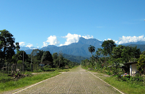
Tunari National Park is located in the western part of Cochabamba Department in Bolivia. This national reserve covers an area of 3,090 km². The climate of the region of Tunari National Park is fairly dry and cool. Its average temperature usually fluctuate between 22C and -5C. It highest mountain is Pico Tunari that reaches and elevation of 5,035 meters. The land here is inhabited by Aymara and Quechua native tribes that co- exist peacefully. City of Cochabamba has a central office dedicated to Tunari National Park and three cabins for tourist use. Additionally you can get extra lodging in the Municipality of Tiquipaya. The national park has several hiking trails. If you want to be on a safe side travel in groups and accompanied by a local guide that ask low prices for their services.
It was declared a National Park by Supreme Decree 6045 of March 30,
1962, Law 253 of November 4, 1963 and Supreme Decree 15872 of August
6, 1978. Its limits were extended by Law 1262 of October 13, 1991,
it is found between geographical coordinates (65º55 '- 66º44' West
Longitude 16º55 '- 17º34' South Latitude). It has an area of
approximately 309,091 ha (3,090 km²).
Weather
The
climate is temperate (mesothermic) on the slopes with average
temperatures of 12 ° C, a maximum of 22 ° C and a minimum of -5 ° C,
with annual rainfall levels below 600 mm, typical of the Valles
region Dry Interandines. In the mountainous area, the climate is
cold and humid with an average temperature of 6.5 ° C, with an
average annual rainfall of 1,200 mm.
Altitude
The
altitudinal range ranges from 2,200 to 5,035 masl (Tunari Peak). The
Park occupies the region of Mesothermal Dry Valleys and Cerro
Tunari, comprising an ecosystem with a diversity of life zones. The
region has the characteristics of mountain ranges and inter-Andean
valleys, with a system of watersheds that supply water to
agricultural land and the city of Cochabamba.
Hydrography
Water flows through the basins and microbasins of the Cordillera,
forming two main slopes: the North slope whose waters contribute to
two hydrographic systems of the great Amazon River basin that are
the Beni rivers to the Northwest and the Mamoré river to the
Northeast through the river Chapare; and the South slope conformed
by the micro basins of the South slope of the Park, that contribute
their waters to the basin of the river Rocha and to the underground
deposits of the valleys by infiltration.
Flora
Corresponds
to the High Andean and Puna biogeographic subregions and Interandean
Dry Valleys.
In the whole of the Cordillera del Tunari there
are two phytogeographic zones:
The hillside region that
corresponds to the valleys and semi-arid mountains of the mountain
range. The vegetation of the first zone is characterized by a
xerophytic tree stratum, with the following species: molle (Schinus
molle), Chirimolle (Fagara coco), carob (Prosopis juliflora), Lloke
(Kageneckia lanceolata), Chacotea (Dodonaea) viscose) the k'inhi
(Acacia macracantha), the alder (Alnus acuminata), the kishuara
(Buddleja hypoleuca) and the thola (Baccharis dracunculifolia).
The mountain region comprises lands of the High Andean Semi-humid
floor, characterized by hillside grasslands and belts of trees and
shrubs in the lower areas. The most representative species are
kewiña (Polylepis besseri) and puna kishuara (Buddleja coriacea).
Among the Kewiña groves, the subspecies (Polylepsis besseri
subtusalbida), exclusive to the Tunari Range, stands out.
However, to date there are no biological studies of much of the
Park. Despite this, to have a more objective view of the flora, it
is still necessary to make a more precise inventory of the
vegetation that exists in the Tunari National Park.
On the
other hand, on the southern slope of the Area there are implanted
pine and eucalyptus forests, afforestation work done both to
stabilize the slopes and areas of streams, and to maintain the
environmental balance of the valleys. Where everything is quiet.
Wildlife
To date, 30 species of mammals, 163 bird species,
two reptile species and two amphibian species were recorded. Four
endemic birds were registered in the Kewiña (Polylepis spp.)
Forests: Oreotrochilus adela, Aglaeactis pamela, Asthenes heterura
and Compsospiza garleppi. This last species is in danger of
extinction. They also inhabit the species Sicalis luteocephala,
Saltator rufiventris, Oreomanes fraseri, Diglossa carbonaria, which
are vulnerable, and Leptastenura yanacensis that has a high priority
for research and conservation.
Nor are there in-depth studies
on the fauna of the Park. However, in addition to endemic species of
birds or mammals in danger such as the spectacled bear (Tremarctos
ornatus), it is likely that there are other endemic species or with
important populations in this territory.
Tourism
At the
moment three tourist areas are exploited, of great importance for
the local population mainly, these are:
The recreational area
that exists in km 10 of the forest mass located north of the city of
Cochabamba, whose access is made from the central office of the
same. This area also has three cabins, about 10 km of ecological
trails and two waterfalls, in addition to the attractiveness of the
pine, eucalyptus and mainly Kehuiña forests.
The Cruzan cabins, located 15 from the city of Cochabamba in the
Municipality of Tiquipaya, have 3 ecological paths each with
particular characteristics and a walk through the ancestral
agricultural systems of the community.
The hot springs of
Liriuni, located 20 km from the city of Cochabamba in the
municipality of Quillacollo. They can go through two roads; the
first is towards Quillacollo on the main road, the second and last
is towards Tiquipaya from Taquiña Crossing.
Population in the
area and its external buffer zone
There are approximately 100
peasant communities, both Aymara and Quechua organized in
sub-centrals and unions, with a total population of around 80,000
inhabitants.