Location: Magallanes and Antártica Chilena Region
Area:
14,600 km2 (5,637 mi2)
Alberto de Agostini National Park, established in 1965, is Chile's third-largest national park, spanning 1,460,000 hectares (approximately 3,607,739 acres) across a remote and pristine region of Patagonia. Named after the Italian Salesian priest, mountaineer, explorer, and photographer Alberto Maria De Agostini, who documented the area's fjords, mountains, and glaciers in the early 20th century, the park protects a unique convergence of terrestrial and marine ecosystems where the Andes Mountains meet the sea. It is renowned for its dramatic glacial landscapes, biodiversity hotspots, and role as part of the UNESCO Cape Horn Biosphere Reserve (designated in 2005 alongside Cabo de Hornos National Park), emphasizing its global significance as one of the planet's 24 most pristine ecoregions. The park exemplifies Chile's commitment to conserving subantarctic environments amid climate change pressures.
The park is situated in the Magallanes y la Antártica Chilena Region of southern Chile, approximately 148 km (80 nautical miles) southwest of Punta Arenas and to the west of Puerto Williams, the southernmost city in the world. It extends across three provinces: Magallanes, Tierra del Fuego, and Antártica Chilena, encompassing parts of the Tierra del Fuego Archipelago, including islands such as Gordon, Cook, Londonderry, and portions of Hoste Island. Geographic coordinates are centered at 54°44′57″S 70°26′23″W. The area features a cold, rainy temperate climate with annual precipitation ranging from 635 to 4,064 mm (25 to 160 inches), median temperatures between 2°C and 9°C (35°F to 48°F), and frequent strong winds, particularly in summer. Its remote position, with no road access, makes it a frontier of Patagonia, bordered by the Pacific Ocean, Beagle Channel, and Darwin Sound.
The park was officially created on January 22, 1965, by incorporating lands from the former "Hollanda" forest reserve and parts of Hernando de Magallanes National Park. It honors Father Alberto Maria De Agostini (1883–1960), who arrived in Patagonia in 1910 as a missionary and spent over three decades exploring the Fuegian channels, climbing peaks like Monte Sarmiento, and producing extensive photographic, cartographic, and documentary records that popularized the region globally. The area has deeper historical roots: Indigenous Yámana (Yaghan) people, the southernmost inhabitants on Earth, lived here for millennia, navigating fjords in bark canoes and sustaining themselves through fishing and gathering. European exploration began with Ferdinand Magellan in 1520, followed by Charles Darwin's visits in the 1830s aboard the HMS Beagle, where encounters with local peoples influenced his evolutionary theories. The park's establishment aligned with Chile's mid-20th-century push for protected areas, evolving into part of broader conservation initiatives like the Route of Parks in the 2010s.
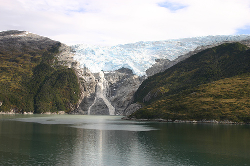
Geologically, the park encompasses the southern terminus of the Andes Mountains, specifically the Cordillera Darwin, a rugged range formed by tectonic forces and glacial erosion over millions of years. Peaks rise dramatically from sea level to over 2,500 meters (8,200 feet), including Monte Darwin (2,488 m/8,163 ft), Monte Sarmiento (2,404 m/7,887 ft), Monte Shipton (2,569 m/8,425 ft), and Monte Bove (2,279 m/7,477 ft). The landscape is dominated by deep fjords (e.g., Agostini and Almirantazgo Sounds), tidewater glaciers descending from the Darwin Icefield (Chile's third-largest icefield), and irregular coastlines shaped by Pleistocene glaciations. Notable geological processes include ongoing glacial retreat, as seen in the Marinelli Glacier, which has receded significantly since 2008 due to climate change. The "Avenue of the Glaciers" along the Beagle Channel features cascading ice formations like the España, Romanche, Alemania, Italia, Francia, and Holanda glaciers. Soils are thin and acidic, supporting peat bogs and tundra, while seismic activity is low but landslides occur during heavy rains.
The park is a biodiversity hotspot within the Magellanic subpolar forests ecoregion, hosting ecosystems from evergreen rainforests to alpine tundra formed post-glaciation around 10,000 years ago. Flora includes dominant trees like coihue (Nothofagus betuloides), canelo (Drimys winteri), lenga (Nothofagus pumilio), ñirre (Nothofagus antarctica), and ciprés de las Guaitecas (Pilgerodendron uviferum), with understory species such as mushrooms, mosses, lichens, centellas, orchids, coicopihues, chauras, and anemones. It boasts Chile's highest diversity of non-vascular plants (e.g., mosses, liverworts). Fauna comprises at least 108 species, including mammals like guanaco (Lama guanicoe), culpeo fox (Lycalopex culpaeus), South American gray fox (Lycalopex gymnocercus), marine otter (Lontra felina), southern elephant seal (Mirounga leonina), leopard seal (Hydrurga leptonyx), South American sea lion (Otaria flavescens), humpback whale (Megaptera novaeangliae), Chilean dolphin (Cephalorhynchus eutropia), Burmeister's porpoise (Phocoena spinipinnis), and Peale's dolphin (Lagenorhynchus australis). Bird species number 49, featuring the southern royal albatross (Diomedea epomophora), Magellanic woodpecker (Campephilus magellanicus), white-crested elaenia (Elaenia albiceps), cormorants, and austral thrush (Turdus falcklandii). Marine invertebrates and killer whales (Orcinus orca) add to the richness, with many species at risk due to habitat sensitivity.
The park's landscapes blend towering mountains, ice-capped peaks, deep fjords, and cascading glaciers, creating a dramatic subantarctic vista. Key features include the Marinelli Glacier (largest at 135 km²/52 mi², 17 km/10.5 mi long, with a 40 m/131 ft ice wall), the pyramid-shaped Monte Sarmiento (first ascended in 1956), and the Avenue of the Glaciers in Seno Pía, an embayment of the Beagle Channel. Other glaciers like Serrano, Rugidor, Pía, Piloto, Nena, Garibaldi, Günter Plüschow, Águila, and Brookes flow into fjords, forming the "Glacier Alley." Notable sites are the Almirantazgo and Agostini Sounds, Brecknock Peninsula with granite walls, and islands hosting peat bogs and tundra. The park's irregular coastline and high plateaus offer serene, untouched wilderness, with seasonal wildflowers adding color in summer.
As part of Chile's National System of Protected Wild Areas (SNASPE) and the UNESCO Cape Horn Biosphere Reserve, the park safeguards a mosaic of ecosystems, including Magellanic evergreen forests, peat bogs, and marine habitats, crucial for global biodiversity. It protects endangered species like the marine otter and southern elephant seal, while addressing threats such as glacial retreat from climate change, poaching, and potential tourism impacts. Managed by the National Forestry Corporation (CONAF), efforts include monitoring glacier dynamics, habitat restoration, and integration into the Route of Parks initiative (spanning 17 parks over 11.8 million hectares) for sustainable development. Collaborations with NGOs emphasize education and low-impact practices to preserve this pristine ecoregion.
As of August 2025, the park remains under CONAF management with no reported major boundary changes or infrastructure developments. Ongoing glacial retreat, particularly of the Marinelli Glacier, continues to be monitored amid broader climate impacts in Patagonia. Conservation priorities focus on biodiversity protection and sustainable tourism, with the Route of Parks initiative enhancing regional connectivity. Visitor access is stable, though remote, and no significant threats like large-scale development have emerged recently. The park's integrity is maintained, contributing to Chile's protected areas network amid global efforts for subantarctic conservation.
Alberto de Agostini attracts adventure seekers for its remote
wilderness, with tourism centered on cruise expeditions and boat tours
rather than land-based activities due to the lack of roads and official
trails.
Top Activities and Attractions:
Glacier viewing along
the Avenue of the Glaciers and fjord cruises to spots like Seno Pía or
Agostini Sound.
Wildlife spotting (whales, seals, birds) from zodiac
boats or during beach landings.
Hiking on beaches and forests when
docking, photography of peaks like Monte Sarmiento, and cultural
insights into Yámana history.
Combined trips with nearby Cabo de
Hornos or Tierra del Fuego.
Practical Tips:
Best Time: October
to April for milder weather and longer days; avoid winter due to extreme
conditions.
Access and Fees: No direct roads; arrive via cruises from
Punta Arenas (e.g., Cruceros Australis, 4-7 day voyages) or Ushuaia,
Argentina; flights to Puerto Williams (DAP Airlines, 1.25 hours from
Punta Arenas) then boat. Entry fee applies (foreigners pay double
Chilean nationals); book permits at pasesparques.cl.
Getting There:
Main ports: Punta Arenas or Puerto Williams; ferries like Transbordadora
Broom (31 hours from Punta Arenas to Puerto Williams).
Regulations:
Follow ranger instructions; no fires, stay on paths, pack out waste;
limited facilities (bathrooms, info centers on some cruises).
Accommodations: Primarily on cruises or expedition ships; no on-site
lodging, but nearby Puerto Williams has options. Pack layers, waterproof
gear, boots, sunscreen, and binoculars.
Nearby: Link with Torres del
Paine (north) or Cape Horn for extended Patagonia tours.
The park
offers an unparalleled, low-impact experience in one of Earth's last
wild frontiers.