Location: Patagonia Map
Area: 1,850 km²
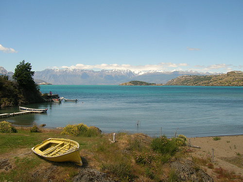
General Carrera Lake, also known as Lake Buenos Aires in Argentina or by its indigenous Aonikenk name Chelenko (meaning "stormy waters"), is a vast, deep glacial lake straddling the border between Chile and Argentina in Patagonia. It is the largest lake in Chile and the fourth largest in Argentina, renowned for its striking turquoise and sapphire waters, dramatic Andean surroundings, and unique geological formations like the Marble Caves. Shared internationally, the lake covers a total surface area of 1,850 km² (710 sq mi), with approximately 970 km² in Chile's Aysén Region and 880 km² in Argentina's Santa Cruz Province. Formed during the last Ice Age, it exemplifies Patagonia's glacial heritage and serves as a vital ecological and cultural landmark, supporting biodiversity, fisheries, and ecotourism while facing climate change pressures. Its binational status highlights cooperative management between the two countries, and it drains into the Pacific Ocean via the Baker River, Chile's most voluminous river.
The lake is positioned in southern Patagonia, within Chile's Aysén del General Carlos Ibáñez del Campo Region (General Carrera Province) and Argentina's Santa Cruz Province (Lago Buenos Aires Department). Its coordinates are approximately 46°26′15″S 71°42′54″W, at an elevation of 203–217 meters (666–712 ft) above sea level. It lies about 230 km south of Coyhaique, the regional capital of Aysén, and is accessible via Chile's Carretera Austral (Southern Highway) on the western side or Argentine routes on the eastern shore. Key settlements include Chile Chico and Puerto Ingeniero Ibáñez on the Chilean side, and Los Antiguos on the Argentine side. The lake is part of a larger glacial lake system in southwestern Patagonia, influenced by the Andes Mountains and the Northern Patagonian Ice Fields. The climate is cold and humid, with frequent strong winds, annual precipitation varying by location (higher in the west), and a sunny microclimate around Chile Chico contrasting the regional weather patterns.
The region around General Carrera Lake has been inhabited by indigenous Aonikenk (Tehuelche) and Mapuche peoples for millennia, with the lake's name Chelenko reflecting its stormy nature in Aonikenk. European exploration began in the late 19th century, with Argentine explorer Francisco Moreno documenting it in 1876, initially conflating it with nearby Colhué Huapí Lake under the Mapuche name Coluguape. Criollos and European immigrants settled the coasts between 1900 and 1925, drawn by agriculture and mining. The Chilean portion was officially renamed General Carrera Lake in 1959, honoring a national hero. Volcanic eruptions from Hudson Volcano in 1971 and 1991 devastated local economies, particularly sheep farming, by covering pastures in ash. A notable environmental event occurred in 1977 when surging glacial waters engulfed the town of Bahía Murta on the lake's shore. Mining for lead and zinc operated at Puerto Cristal from 1931 to 1996. In recent decades, the construction of the Carretera Austral has opened the area to tourism, transforming it from an isolated frontier to a key destination in Patagonia's "Route of Parks."
General Carrera Lake occupies a continental-scale graben formed by southwest-northeast normal faults, with its basin down-dropped to about 350 meters below sea level. This tectonic structure, linked to subduction processes over the past 20 million years, channeled Pleistocene glaciers, creating terminal moraines that dammed the lake. The lake has a catchment area of 14,861 km², a shoreline of 707 km, an average depth of 400 m (1,300 ft), and a maximum depth of 586 m (1,923 ft), making it one of the deepest in the Americas. Its volume is estimated at 740 km³. Geologically, the region dates to the Jurassic period (about 200 million years ago), with tectonic activity forming the Andes. Volcaniclastic sediments along the southern shore show ripple marks, and river deltas (e.g., Maitenes, Aviles, Jeinimeni) indicate past higher lake levels. The lake's turquoise color stems from glacial meltwater rich in rock flour (fine sediment). Outflows include the Baker River to the Pacific, with historical drainage to the Atlantic via the Deseado River during glaciations. Mineral deposits like lead and zinc are present on the northwestern shores.
The lake and its surroundings support a diverse ecosystem adapted to Patagonia's cold, mountainous environment. Aquatic biodiversity includes introduced species like rainbow trout, brown trout, and salmon, making it a prime fishing destination, alongside native Patagonian silverside. The lake's cold, clear waters foster invertebrates and algae, though glacial silt limits some plankton growth. Terrestrial habitats feature Valdivian and Magellanic forests with lenga (Nothofagus pumilio) and coihue (Nothofagus dombeyi) trees, providing refuge for endangered mammals like the huemul deer, puma, wildcat, and southern viscacha. Birdlife is rich, with species such as Andean condor, black-chested buzzard-eagle, torrent duck, Magellanic woodpecker, and black-necked swan. Wetlands along the Baker River add to avian diversity. The area's isolation has led to high endemism, but invasive species and habitat fragmentation pose threats.
The lake's landscapes are characterized by rugged Andean peaks, evergreen forests, and vibrant turquoise waters that shift hues with light and weather. Notable features include the Marble Caves (Capillas de Mármol), a series of caverns, tunnels, and columns eroded from marble monoliths over 6,200 years by wave action, forming the Marble Cathedral, Chapel, and Cave—stunning blue-green formations reflecting in the water. Other highlights are the Northern Patagonian Ice Fields with glaciers like San Rafael, Exploradores, and Leones; river deltas showing ancient shorelines; and the Baker River's canyons and rapids. The Malvinas Islands (not to be confused with the Falklands) dot the lake, and settlements like Chile Chico offer temperate oases with fruit orchards amid the windy, stormy conditions.
As part of Chile's Route of Parks—a 1,500-mile chain of 17 national parks covering 11.8 million hectares—General Carrera Lake is crucial for preserving Patagonia's biodiversity and glacial ecosystems. It anchors conservation in the Aysén Region, protecting watersheds, endangered species like the huemul, and the third-largest ice field in the world (Northern Patagonian Ice Fields). Efforts by CONAF (Chile's National Forestry Corporation) and binational agreements with Argentina focus on sustainable tourism, invasive species control, and monitoring glacial retreat due to climate change. Challenges include erosion from tourism, pollution, and historical mining impacts. Local guidelines limit boat access to Marble Caves, and initiatives like those in Patagonia National Park promote rewilding and community involvement. The lake's environmental importance is amplified by its role in regional hydrology and as a buffer against deforestation.
As of August 2025, General Carrera Lake remains in stable condition, with high water quality supporting fisheries and tourism. Glacial retreat continues due to climate change, as noted in ongoing monitoring of the Northern Patagonian Ice Fields, but no major incidents like the 1977 surge have been reported recently. Tourism has boomed post-pandemic, aided by improved access via the Carretera Austral, though sustainable practices are emphasized to mitigate overcrowding. Conservation efforts persist, with no significant boundary changes or threats documented in recent sources, maintaining the lake's integrity amid regional development.
General Carrera Lake draws adventurers for its remote
beauty, with peak visitation in summer (December–March) for milder
weather (up to 20°C).
Top Activities and Attractions:
Boat or
kayak tours of the Marble Caves (30–60 minutes, ~$20–50), offering close
views of eroded formations.
Fly-fishing, rafting, and kayaking on the
Baker River's rapids and waterfalls.
Trekking and mountain biking in
Patagonia National Park, including multi-day hikes like Gloria Pass.
Wildlife spotting (condors, pumas) and glacier excursions in Laguna San
Rafael National Park.
Horseback riding, sailing, and cultural visits
to indigenous sites.
Practical Tips:
Best Time: Summer for
activities; shoulder seasons for fewer crowds.
Access and Fees: Fly
to Balmaceda Airport (near Coyhaique), then drive 4–5 hours via
Carretera Austral; ferries operate between Puerto Ibáñez and Chile Chico
(~2 hours). No lake entry fee, but tours and parks charge ~$10–30.
Getting There: Rent a 4x4 for rugged roads; buses from Santiago to
Coyhaique (20+ hours).
Regulations: Use licensed guides for caves;
no-touch policy for formations; pack layers, sunscreen, and insect
repellent due to winds.
Accommodations: Eco-lodges in Puerto Río
Tranquilo or Chile Chico (~$100–300/night); camping in parks.
Nearby:
Combine with Jeinimeni National Reserve or cross to Argentina's Perito
Moreno Glacier.
The lake offers immersive, low-impact
experiences, with lodges providing local cuisine for recovery.