Location: Arica-Parinacota Region Map
Area: 1,379 km²
Lauca National Park (in Aymara: jjyghgu'a 'aquatic
pasture') was created in Chile in 1965 as a forest reserve and
acquired its current status in 1970 as a national park. Its surface
reaches 137,883 hectares. It includes the foothills and the Andean
highlands, at altitudes between 3,200 and 6,342 meters above sea
level. n. m., in the extreme east of the region of Arica and
Parinacota, commune of Putre, province of Parinacota, being north of
the Las Vicuñas national reserve. At its western end it limits with
the Lluta River and to the east with the border with Bolivia. Its
name is shared with the Lauca River.
This national park
represents not only the high plateau, but also has part of its
surface in the pre-altiplano desert steppe, located in the
foothills.
It presents rains in summer and snow in winter;
the climate is dry with 280 mm. of average annual precipitation and
an average temperature that oscillates between 12 and 20 °C during
the day and -3 to –10 °C at night.
The relief of the park is,
in general, irregular. The Parinacota volcanoes, 6342 m above sea
level; Pomerape, 6282 m above sea level; Guallatiri, 6060 m above
sea level, and Acotango, 6050 m above sea level.
In 1981, the
park became part of the world list of UNESCO biosphere reserves.
The Chilean government is studying the disaffection of part of
this national park to allow mining exploitation by Codelco, Anglo
American, BHP and Río Tinto.
Representative flora
Even when the unit features many more plant
species than those listed below, these are the most relevant and easy to
observe:
Chachacoma (Senecio sp).
Llareta (Compact Azorella).
Brave straw (Festuca orthophylla).
Quenoa (Polylepis besseri).
Tola (Fabiana densa).
Highland Quenoa (Polylepis tarapacana).
Representative fauna
Only those species more conspicuous or easy to
observe are noted:
Mammals
Puma (Puma concolor concolor).
Taruca (Hippocamelus antisensisis).
Vicuña (Vicugna vicugna).
Vizcacha (Lagidium viscacia).
Andean Culpaeus Fox (Lycalopex culpaeus
andinus).
Northern guanaco (Lama guanicoe cacsilensis).
Birds
Caití (Andean Recurvirostra).
Pune Marsh Crow (Plegadis ridgwayi).
Chilean Flamingo (Phoenicopterus chilensis).
Andean gull
(Chroicocephalus serranus).
Piuquen (Chloephaga melanoptera).
Partridge (Tinamotis pentlandii).
The woodpecker (Rhea pennata
tarapacensis).
Northern chick jergon duck (Anas flavirostris
oxyptera).
Giant Tagua (Fulica gigantea).
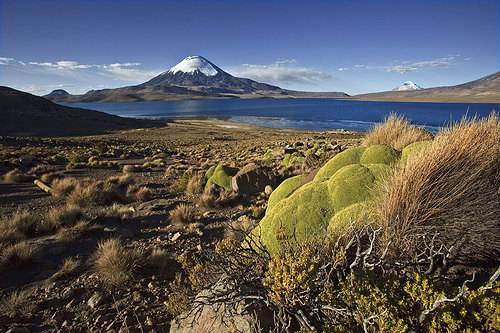
Sites of greatest
scenic beauty
The most attractive places in this park are Lake
Chungará (large emerald green lake) with the Payachatas snowfields,
Chungará tambo (archaeological site), Parinacota (17th century colonial
indigenous architectural set), the Cotacotani lagoons (set). of
interconnected waters), Chucuyo (populated by adobe houses with thatched
roofs), Rocky and Chacus refuge Inca Las Cuevas (archaeological sites),
termas Las Cuevas (waters flowing from the bofedales at 31 °C), Lauca
River (in the vicinity of the hills Chapiquiña and Milagro) and the
bofedal of Parinacota.
Access roads
The park is accessed via
the Arica- La Paz International Highway, Route 11-CH. It is located 14
km from the town of Putre and 187 km from the city of Arica.The city of
Arica is 30 meters above sea level and the town of Putre at an altitude
of 3,550 meters.
Protection of the subfloor
The Lauca national
park has a protection of its subsoil as a place of scientific interest
for mining purposes in accordance with the official listing of the
Ministry of Mining, as stipulated in Article 17 of the Mining Code.
These works can only be executed by means of a written permit by the
President of the Republic and signed in addition by the Minister of
Mining. The prohibition of an absolute character for mining exploration
and exploitation of the soil and subsoil is not contemplated in Chilean
legislation.
The condition of a place of scientific interest for
mining purposes was established by Supreme Decree No. 36 of 11 April
1986 and published on 30 March 1988. which fixes the protection polygon.