Location: Map
Area: 116 km²
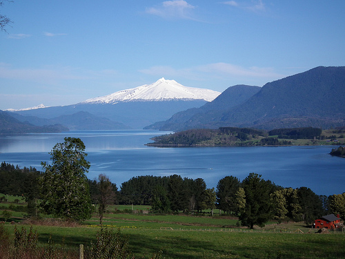
Panguipulli Lake (Lago Panguipulli), translating to "Puma hill" in Mapudungun (the Mapuche language), is a prominent glacial lake in southern Chile, renowned for its crystal-clear turquoise waters, surrounding Valdivian temperate rainforests, and dramatic Andean landscapes. As one of the "Seven Lakes" in the Panguipulli municipality—alongside Calafquén, Pullinque, Pellaifa, Neltume, Pirihueico, and Riñihue—it forms a key part of the Lake and Volcano Scenic Route, a 2,000-kilometer corridor promoting ecotourism across three regions. The lake spans approximately 116-117 km², with a maximum depth of 268 meters, making it the fourth-largest in the Los Ríos Region. Of glacial and moraine-dammed origin, it exemplifies the region's volcanic and tectonic history, supporting diverse biodiversity and serving as a hub for sustainable tourism, outdoor adventures, and cultural experiences tied to Mapuche heritage. Its pristine environment balances natural beauty with growing conservation efforts amid increasing visitor numbers.
Panguipulli Lake is situated in the Los Ríos Region of southern Chile, within the Valdivia Province and Panguipulli Commune, approximately 145 km south of Temuco (the nearest major airport) and 75 km from Pucón. Its geographic coordinates are 39°41′39″S 72°14′30″W, at an elevation of 140 meters above sea level. The lake lies in the Andean foothills, enclosed by mountain ranges on all sides except the west, where the town of Panguipulli sits in the Chilean Central Valley. Key nearby settlements include Choshuenco (on the southern shore), Coñaripe (eastern shore), and Neltume (northeast). It is part of the broader Lake District, connecting to other lakes via rivers and forming the Seven Lakes Circuit. The climate is temperate rainy, with annual precipitation around 2,000-3,000 mm, average temperatures of 15°C (ranging from 3°C in winter to 25°C in summer), and marked seasonal variations—dry summers and wet winters, influenced by the Pacific Ocean and Andean barriers.
The lake's history is deeply intertwined with indigenous Mapuche communities, who have inhabited the region for centuries and named it after the puma, a sacred animal in their cosmovision. Geological events, such as volcanic eruptions and earthquakes, have influenced Mapuche legends and worldview, viewing natural forces as integral to spiritual life. European settlement began in 1885 with Guillermo Angermaier, the first recorded colonist, followed by a Capuchin mission in 1903 that established religious and educational influences. The town of Panguipulli was officially founded in 1946, evolving from a frontier outpost into a commercial and touristic center. Infrastructure developments included a pebbled road in 1935, railroad arrival in 1954, and the completion of the lake-circumventing road in 1983, despite seasonal challenges. The area has a logging history, with Neltume's Memory Museum documenting the industry's past and social struggles during the Pinochet dictatorship (1973-1990). In the 20th century, unregulated logging gave way to conservation initiatives, such as the private Huilo Huilo Biological Reserve established in 1996, shifting focus from exploitation to protection and ecotourism.
Panguipulli Lake is a classic glacial, moraine-dammed ribbon lake, formed during the Pleistocene era by retreating glaciers and tectonic activity along geologic faults. It measures 29.78 km in length, 14.81 km in maximum width, with an average depth of 126 m and a maximum of 268 m, holding a water volume of 14.74 km³. The shoreline extends 124 km, featuring bays like Coique and islands such as Gabriela. Primary inflows include the Llanquihue and Pullinque Rivers, while it drains southward via the Enco River to Riñihue Lake, contributing to the Valdivia River basin that flows to the Pacific. Geologically, the basin includes deposits from the middle to late Triassic periods, with the surrounding Andes shaped by subduction processes, volcanism (e.g., Mocho-Choshuenco Volcano), and earthquakes. The lake's clear waters result from low sediment input, though remote sensing studies show intra-lake variations in temperature, turbidity, and chlorophyll-a due to glacial melt and river inflows. The terrain features steep slopes, ravines, wetlands, and hot springs from geothermal activity.
Panguipulli Lake lies within the Valdivian temperate rainforest biome, a global biodiversity hotspot with high endemism. Flora includes ancient species like araucaria pines (Araucaria araucana), tree ferns (Dicksonia berteriana), and evergreen trees such as coihue (Nothofagus dombeyi) and canelo (Drimys winteri), thriving in dense forests and wetlands. Fauna features endangered mammals like the huemul deer (Hippocamelus bisulcus), pudú (Pudu puda), Darwin's fox (Lycalopex fulvipes), and monito del monte (Dromiciops gliroides). Birdlife is diverse, with species such as the Magellanic woodpecker (Campephilus magellanicus), torrent duck (Merganetta armata), and black-necked swan (Cygnus melancoryphus). Aquatic biodiversity includes native mussels (Diplodon chilensis) and introduced fish like rainbow trout and salmon, supporting sport fishing but posing invasion risks. Studies highlight gradients in fish species richness, with native species declining due to introductions. Surrounding reserves like Huilo Huilo protect endemic and threatened species, emphasizing the lake's role as a refuge amid habitat fragmentation from past logging.
The lake's landscapes blend turquoise waters with lush green forests, snow-capped volcanoes, and rugged mountains, creating a dreamlike setting. Notable features include fine-sand beaches at Choshuenco and Chueque; Gabriela Island; and bays like Coique and Guapi. The eastern shores near Coñaripe host geothermal hot springs (e.g., Trafipán, Liquiñe River) and waterfalls, while the Fuy and Enco Rivers offer dramatic canyons for rafting. The Mocho-Choshuenco Volcano (2,422 m) looms prominently, with millenary glaciers visible in winter. Nearby attractions include the Huilo Huilo Biological Reserve's canopy walks and the Villarrica National Park's trails. The area features Valdivian jungle, rivers, and wetlands, ideal for panoramic views and photography, with seasonal wildflowers enhancing spring scenery.
Panguipulli Lake is crucial for conserving the Valdivian rainforest, a biodiversity hotspot comparable to coastal forests in Aysén, protecting endemic species and watersheds amid threats like deforestation and invasive fish. Key efforts include the Huilo Huilo Biological Reserve (100,000 hectares, established 1996 after logging cessation), focusing on restoration, education, and sustainable tourism. The Mocho-Choshuenco National Reserve safeguards glaciers and forests. Initiatives by CONAF and local communities emphasize participatory governance, environmental education, and infrastructure like low-impact trails to minimize tourism effects. Mapuche-led community tourism promotes relational values and cultural preservation. Challenges include historical logging and paved roads increasing access, addressed through protected corridors and biosphere models. The lake contributes to Chile's national conservation strategies, including landscape connectivity with nearby parks.
As of August 2025, Panguipulli Lake maintains high water quality and ecological health, with remote sensing indicating variations in surface temperature, turbidity, and chlorophyll-a, but no major degradation reported. Tourism has grown post-pandemic, balanced by sustainable initiatives. Conservation monitoring continues in reserves, focusing on climate resilience (e.g., altered rainfall from El Niño) and invasive species. The area remains a vibrant ecotourism hub, with no significant environmental incidents or boundary changes noted recently.
Panguipulli Lake attracts nature enthusiasts
year-round, with peak seasons in summer (January-March,
November-December) for warmer waters (up to 22°C) and drier weather, and
winter for thermal springs and snow views.
Top Activities and
Attractions:
Water sports: Kayaking, windsurfing, water skiing,
boating, and sport fishing (trout, salmon).
Land-based: Trekking in
Huilo Huilo (canopy walks, waterfalls), hiking in Mocho-Choshuenco
Reserve, mountain biking, horseback riding.
Relaxation: Hot springs
near Coñaripe (e.g., Geometric Hot Springs), beach time at Choshuenco.
Cultural: Mapuche ethnotourism, visits to Neltume's Memory Museum, wood
art in Liquiñe (World Craft City since 2018).
Nearby: Seven Lakes
circuit drives, Villarrica Volcano, Puerto Fuy ferry to Argentina.
Practical Tips:
Best Time: Summer for water activities; shoulder
seasons for crowds and foliage.
Access and Fees: Drive from Temuco (2
hours) or Pucón (90 minutes); buses from Santiago (~12 hours). No lake
entry fee; reserves charge ~$10-20. Book tours online (e.g., Huilo Huilo
packages from $393 for 3 days).
Getting There: Fly to Temuco (PMC),
rent a car for flexibility on Ruta 203.
Regulations: Use accredited
guides for reserves; no fires outside areas; respect Mapuche sites;
eco-friendly practices encouraged.
Accommodations: Eco-lodges in
Huilo Huilo (~$150-300/night), cabins in Panguipulli/Coñaripe
(~$50-100); camping available.
Nearby: Combine with Calafquén Lake
(north) or Ranco Lake (south) for circuit tours.
The lake offers
immersive, sustainable experiences, supporting local economies through
gastronomy (honey, cheese, cider) and community tours.