Area: 40,600 mi2 (105,200 km2)
Average rainfall: 0- 0.08 in a year
The Atacama Desert, Atacama for short, stretches along
the Pacific coast of South America between the 18th and 27th parallel
south, i.e. roughly between the cities of Tacna in southern Peru and
Copiapo in northern Chile, over a distance of around 1200 kilometers.
Three longitudinal zones are distinguished from west to east: the
Cordillera de la Costa, the intermediate valley and the Andes massif.
The Atacama is a coastal desert and the driest desert on earth
outside of the polar regions. A hyperarid climate has existed in its
central region for at least 15 million years. There are places where no
rain has been recorded for decades, with average annual precipitation
totals of just 0.5 mm. Its southern area between the 24th and 27th
degree of latitude therefore remained completely uninhabited until
recent historical times.
Its origin dates from about three million years ago, being in its
past a sea bed. The main cause of its origin is a climatic phenomenon
known as the Fohn effect, produced on the eastern slopes of the Andes
mountain range. This causes the clouds to dump their precipitation on
only one face of the mountain in their vertical ascent; When crossing
the mountain range, the clouds do not have water, thus generating a
desert by completely blocking all possible precipitation from the east.
Precipitation is also blocked from the west by stable high-pressure
systems, known as "Pacific highs," which stay close to the coast,
creating easterly trade winds that move storms.
On the other
hand, the Humboldt Current carries cold water from Antarctica northward
along the Chilean and Peruvian coasts, which cools westerly sea breezes,
reduces evaporation, and creates a thermal inversion—cold air trapped
below a layer of warm air—, preventing the formation of large
rain-producing clouds. All the moisture progressively created by these
sea breezes condenses along the steep slopes of the Coastal Range that
face the Pacific, creating highly endemic coastal ecosystems made up of
cacti, succulents, and other specimens of xerophytic flora.
The
last factor contributing to the formation of the desert is the Andes
mountain range, which in the north forms a high and wide volcanic plain
known as the Altiplano. Just as in the south the Andean mountain range
helps capture moisture from the Pacific, in the north the Altiplano
prevents moisture-laden storms from the Amazon basin to the northeast
from entering Chile.
The Atacama lies in the rain shadow of the Andes; East winds that
occur are dry and bring no precipitation. Near the coast, a cold ocean
current, the Humboldt Current, prevents the development of rain clouds,
so that, unlike further north or south, there is no downpour. However,
the cold sea water means that the Atacama is cool and fog often
prevails, especially near the coast, which is why the Atacama is also
one of the foggy deserts. Due to the effects of the El Niño climate
phenomenon, which is accompanied by a lag in the Humboldt Current, heavy
precipitation occurs relatively regularly at intervals of around six to
ten years. These then lead to the blossoming of the desert for a short
period of time.
In February 2012, as in the previous year, heavy
rainfall destroyed roads and caused landslides. In Toconao and Río
Grande, for example, houses were washed away and fields destroyed, and
residents were cut off from the drinking water supply for weeks.
The average annual rainfall here is only about one fiftieth of the
amount of rain measured in Death Valley in the USA. There are weather
stations in the Atacama that have not recorded precipitation for many
years. There are, especially in the intermediate valley, very large
differences between the maximum temperatures during the day (30 °C) and
the minimum temperatures at night (−15 °C).
Its flora and fauna is conditioned by aridity. The vegetation in this
place, capable of surviving and adapting to its extreme climate,
corresponds to different species of cacti. The orography of the desert
territory produces small water holes in the area, that is, small pools
of water that give rise to another type of vegetation. When the amount
of water increases, species such as the emerald, the pica or the matilla
sprout.
Regarding the fauna, there are some birds such as
hummingbirds (cordillerano, Arica, cora, Puna, northern and giant, among
others), turtledoves and doves (Bolivian, spotted wings, Puna and
quiguagua, among others). Dry riverbeds known as "desert rivers" also
appear, providing habitat for various species. The fauna that can be
found in these places are owls (chuncho del norte, lechuza, pequén,
tucúquere), guanacos, vicuñas and foxes (chilla and culpeo), among
others.
Due to the climatic and altitude conditions of this area,
the fauna and flora are different from those of the neighboring
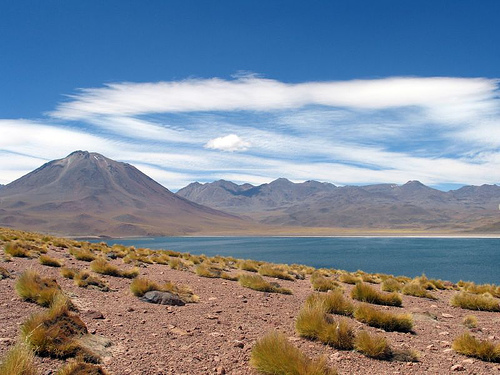
territories. Despite the fact that the area is desert, it has lagoons,
known as Chaxa, Meniques and Puriguatin, which constitute an important
tourist center and ecological and natural attraction of this territory.
They allow the growth of different flowers, such as the cachiyuyo, the
llareta and the paja brava, among others. The Los Flamencos National
Reserve is located in this area, one of the busiest tourist spots.
The geographical description of the Atacama Desert is based on
climatic, botanical or even political perspectives and has therefore
changed several times over the last 500 years. As a result, the regional
delimitation of the area is also currently described inconsistently and
often only vaguely.
The toponym Atacama was adopted by the
indigenous population by the Spanish conquistadors in the 16th century.
It may come from Quechua, the language of the Incas, from p'atacama,
which can mean "meeting place," or "area of trees." The latter because
there were many more trees there at the time. Or it could come from
Kunza, the language of the Lickan Antai, also called Atacameños (people
of Atacama) by the Spaniards, from tecama (I'm cold), or atchcmar
(people).
The Atacama Desert was referred to by the Spaniards as
the Gran Despoblado (The Great Uninhabited; The Great Wasteland),
Desierto de Atacama (Desert of Atacama), or Despoblado de Atacama
(Uninhabited Area of Atacama). A first brief report was published in
1553 by Cristóbal de Molina. He described the area as a sandy landscape
of 100 leagues (1 Spanish league approx. 5.57 km) where there is very
little water and no grass or green things; There isn't one in the whole
wasteland, only in four or five places. The first systematized treatise
followed in 1558 by Jerónimo de Vivar, a chronicler and chorological
geographer who had himself traversed and explored the desert. He
described the Atacama Desert as the area between the sea and the snowy
Andes, bounded by the Atacama Valley (today San Pedro de Atacama) to the
north and the Copiapó Valley to the south, and bordered and
criss-crossed by mountains to the west and east becomes. So a strip of
land 560 km long between 23° South and 27.5° South. He describes the
desert as a barren, very spacious area with little water, no trees, but
with firewood, without population and apparently also without
settlements. At the same time, he recognized that the Atacama Desert is
just one segment of a series of deserts that stretch along the South
American coast from around Tumbes near the equator to the Huasco Valley
in central Chile over a distance of 3000 km.
The Atacama Desert
was mainly a transit route for the Spaniards to get overland from Peru
to Chile, but otherwise of only occasional interest. That changed in the
mid-19th century when, motivated by the discovery of rich mineral
resources, the young independent states on the Pacific wanted to take
control of the little developed and poorly documented territories in
this region and sent naturalists and surveyors there for the first time.
The Prussian Rudolph Philippi led an expedition to Chile. He described
the Atacama Desert from a Chilean perspective as the area between the
southernmost course of the Río Loa (At 22.5° South, near Calama) and the
Río Salado (At 26.5° South; near Chañaral), with the Pacific as the
western border and the Andes Cordillera as the eastern border. In a
physical map from 1856, which is based on the work of Philippi and his
geometer Döll, the designation "Actual Atacama Desert" can be found for
the area of the depression between the "Coastal Mountains" in the west
and the "Andes of Atacama" in the east and the rivers Loa to the north
and Salado to the south. Soon after, for political reasons, the northern
boundary of the Atacama Desert was pushed further north to Pisagua (at
19.5° S), which included the area of the so-called Pampa del Tamarugal.
In the mid-20th century, modern science developed a different
picture of the desert, focusing more on climate and vegetation zones to
define geography. According to this, the Atacama Desert is the southern
part of a larger entity called the Peru-Chile Desert, also known as the
Atacama-Peruvian Desert or the Pacific Desert. This coastal desert
stretches for more than 3,500 km along the Pacific Ocean from Peru's
northern border with Ecuador at 5° S (starting with the Sechura Desert)
to central Chile, to the city of La Serena at 29°55' S. In its broadest
climatic definition, the Peru-Chile desert even extends over 4300 km
from 1° south (near Manta, Ecuador) to 37° south (near the city of
Concepción). The natural spatial connection has led to the fact that the
entire Chile-Peru desert was often referred to as the Atacama. However,
this terminology has not prevailed for political reasons, instead the
area was divided into the Peru Desert in Peru and the Atacama Desert in
Chile.
Thus the northern limit of the Atacama Desert has
sometimes been or is placed in southern Peru at Arequipa, at 16° S, or
at Tacna, at 18° S and Arica, at 18°20" S near the Peruvian-Chilean
border mostly simply equated with Chile's northern border.
The
southern limit of the Atacama Desert is usually set either at the Río
Copiapó (27°20"S, 27°S), where the hyperarid climate zone ends, or 280
km further south at the Río Elqui at La Serena (29°55"S, 30°). South),
where the desert succulent communities give way to semi-arid coastal
scrubland.
The coastal cordillera forms the western boundary of
the Atacama Desert. This is a narrow mountain range up to 2000 m high,
which starts at Arica and runs south along the coast for a distance of
1000 km. For the first 200 km, between Arica and Iquique, it drops
abruptly to the sea in sheer, kilometer-high cliffs, either directly or,
more rarely, over narrow terraces carved by waves. South of Iquique the
cliffs are not quite as high and at the foot of the cliffs there are
some narrow coastal plains from 1 to 3 km wide. Coastal vegetation only
exists as far as the coastal fog reaches, up to a maximum of 1000 m. The
western border is thus defined relatively precisely.
According to
botanical criteria, the eastern boundary of the Atacama Desert is
assumed to be in the Andean Precordillera. The whole area below 2000 to
3000 m above sea level is considered to belong to it, which includes the
lower bare slopes of the Andes. In the range from 2000 to 3000 m,
varying with latitude, the shrub-steppe (with Baccharis incarum, locally
called tolar) begins to dominate. For simplification, it is also stated
that the eastern boundary fluctuates around the 2500 m contour line,
where precipitation levels begin to exceed 20 mm/a. The zone that joins
in the east above the Atacama Desert is called the so-called Andean
Desert. The eastern border can also be broader, so that the southern
foothills of the Altiplano with an average of 3750 m above sea level. M.
be included.
Because the geographical boundary of the Atacama
Desert is defined according to different concepts, this leads to
different area figures. The determination of the area depends
particularly on where the eastern limit is set. Accordingly, the
information on the size of the Atacama Desert varies between 105,000 km2
and 180,000 km2, depending on what the respective author values.
The Atacama Desert is about 15 million years old. Although the
Atacama is one of the most arid areas in the world, it was settled
relatively early. The peoples of the Atacameños, the Aymara, the
Diaguitas and the Chinchorros settled in the few oases. The latter are
best known for their mummified babies buried more than 7000 years ago.
In the 15th century the area became part of the Inca Empire. In 1536,
the conquistador Diego de Almagro became the first European to cross the
Atacama. After the fall of the Inca rule, the desert came under Spanish
rule. The independence efforts of the South American states let the
Atacama fall to Bolivia.
The silver deposits discovered in
Chañarcillo in 1832 made Chile a major silver producer. In the Saltpeter
War (1879-1884) Chile was successful with British support against Peru
and Bolivia and was even able to gain new territory in the north. Until
then, today's Región de Atacama was the northernmost province of Chile.
As a result of the war, Bolivia lost its direct access to the Pacific
Ocean - a point of conflict that still smolders between the two states
today.
In 1916 the exploitation of the copper deposits at
Potrerillos began.
In 2003, the Atacama-Humanoid mummy, named
after the desert, was found.
Due to the extremely dry desert climate, several large observatories
have been built on the mountains in the desert. The observatories La
Silla and Las Campanas are about 50 km south of Vallenar. The European
Southern Observatory has set up the Paranal Observatory on the Cerro
Paranal mountain, 120 km south of the port city of Antofagasta. Other
telescopes are the Atacama Large Millimeter Array on the Chajnantor
Plateau and the Atacama Pathfinder Experiment. Furthermore, one of the
world's largest telescopes, the ELT, is currently under construction on
Cerro Armazones.
The US used the Atacama Desert to test some of
their Mars probes.
The mineral atacamite was discovered in this
desert in 1801 and named after it.
Today, the deposits of lithium, copper, silver, gold and platinum form an economic basis for Chile. The largest lithium deposits in the world are suspected here. In nets, the atrapanieblas, coastal fog is caught on mountain slopes in the Atacama, which is used to collect water. Several pilot projects are running in Chile.
The Atacama desert is considered the best place on the planet to observe the firmament and develop astronomy: its height with respect to sea level, the low cloudiness, the almost non-existent humidity of the air and the distant light and radioelectric pollution make visibility of your night sky is very sharp. Due to this, more than a dozen observatories are located in this place —such as Paranal (VLT), the most advanced and powerful astronomical complex on the planet, ALMA, the largest astronomical project in the world, and La Silla, among others. —. Chile has 40% of the world's astronomical observation; however, in the coming decades, the sector will develop other projects —such as the Giant Magellan Telescope, the Large Synoptic Survey Telescope (LSST), the E-ELT and the expansion of the Atacama Large Millimeter Array— that will make the north of the country concentrates close to 70% of the world total.
The Atacama desert welcomes the world's off-road athletes. In this
desert, the various championships of the Baja Atacama Rally, Baja Chile
Rally, Patagonia Atacama Rally have been held, and it hosted the Dakar
Series Rally —in 2009, 2010, 2011, 2012, 2013, 2014 and 2015—, an event
organized by Amaury Sport Organization (ASO). The dunes of this desert
are ideal for this type of sport, located in the outskirts of the city
of Copiapó, Atacama Region.
Another event that takes place in
this desert is the "Atacama Solar Race", which consists of a race of
solar vehicles that takes place in places in the desert such as Toconao,
Calama, Iquique and Antofagasta, among others.