Location: Rio Grande do Sul, Santa Catarina Map
Area: 103 sq km
Aparados da Serra National Park, established in 1959, is one of Brazil's oldest national parks and a premier destination for ecotourism and conservation in southern Brazil. Spanning approximately 10,250 hectares (102.5 km²), the park is renowned for its dramatic canyons, lush ecosystems, and rich biodiversity. It was created primarily to protect the iconic Itaimbezinho Canyon and surrounding landscapes, which showcase ancient geological formations from volcanic activity. The name "Aparados da Serra" translates to "cut mountains," reflecting the park's steep escarpments and incised valleys. Often managed in conjunction with the adjacent Serra Geral National Park (established in 1992, adding 17,300 hectares), the combined area forms a vital conservation unit within the Atlantic Forest biome, balancing natural preservation with sustainable tourism.
The park is situated in the Serra Geral mountain range, an extension of the Serra do Mar system, straddling the border between the states of Rio Grande do Sul and Santa Catarina in southern Brazil. Its geographic coordinates range from 29°07’ to 29°15’ S latitude and 50°01’ to 50°10’ W longitude. The nearest major town is Cambará do Sul in Rio Grande do Sul, about 190 km northeast of Porto Alegre, the state capital. Access is primarily via highways like RS-020 or BR-101, leading to entrances such as Portaria Gralha Azul near Cambará do Sul or through Praia Grande in Santa Catarina. The park's elevation varies significantly, with high plateaus around 1,000 meters above sea level dropping into deep canyons, creating a diverse microclimate influenced by subtropical conditions, with average temperatures around 16°C and annual rainfall between 1,500-2,250 mm.
Aparados da Serra was founded on December 17, 1959, by Federal Decree No. 47,446, making it one of the pioneering national parks in Brazil alongside Itatiaia (1937) and Serra dos Órgãos (1939). Its establishment was driven by the need to safeguard the region's unique canyons and ecosystems amid growing deforestation and agricultural expansion. Initially covering 13,000 hectares, the park's boundaries were adjusted in 1972 to 10,250 hectares. In response to conservation needs, the contiguous Serra Geral National Park was created in 1992 to expand protection. Historically, the area was influenced by indigenous peoples and later by European settlers, with farming and cattle ranching shaping the landscape. Over the decades, management has evolved under the Chico Mendes Institute for Biodiversity Conservation (ICMBio), with a Management Plan approved in 2004 and updated in 2019 to integrate biodiversity protection with socio-economic benefits for local communities.
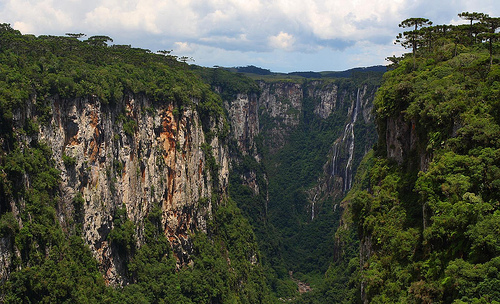
The park's geography is defined by a continental escarpment featuring elevated plateaus and deeply eroded fluvial valleys, part of the Paraná Basin. Geologically, it is dominated by volcanic rocks from the Serra Geral Group, formed during the Paraná-Etendeka Large Igneous Province around 130 million years ago, overlaid with sedimentary layers like the Botucatu Formation. Erosion has sculpted dramatic features, with rates as low as 6 meters per million years on the plateau and up to 50 meters per million years along the escarpment, due to the rocks' high resistance. Key landscapes include steep cliffs over 700 meters high, narrow canyons, and waterfalls, creating a mosaic of habitats from high-altitude grasslands to forested slopes. The terrain's ruggedness contributes to isolated microhabitats, enhancing the park's ecological diversity.
Aparados da Serra is a biodiversity hotspot at the convergence of coastal forests, grasslands, and Araucaria moist forests (part of the Atlantic Forest biome). Flora includes rare species adapted to varying altitudes, such as Araucaria pines in humid forests, diverse orchids, and ferns in shaded valleys, alongside grasslands renewed by natural fires. The park supports at least 143 bird species (e.g., red-spectacled amazon parrot, vinaceous-breasted amazon, black-capped piprites, yellow cardinal), 48 mammals (including endangered maned wolf, cougar, ocelot, brown howler monkey, neotropical otter), and 39 amphibians (e.g., lambari fish). This richness stems from the park's altitudinal gradients and isolated canyons, which act as refuges for endemic and threatened species. Conservation monitoring highlights the importance of these habitats in maintaining regional ecological balance amid broader deforestation pressures in Brazil.
The park's standout features are its canyons, including:
Itaimbezinho Canyon: 5.8-8 km long, up to 720 meters deep and 200 meters
wide, with viewpoints like Mirante da Ferradura offering panoramic
vistas; its name means "cut rock" in Tupi-Guarani.
Fortaleza Canyon:
7.5 km long with walls up to 800 meters, featuring observation decks for
sunrise/sunset views.
Malacara and Índios Coroados Canyons: Smaller
but equally dramatic, with trails leading to pools and waterfalls.
Waterfalls such as Véu de Noiva (Bride's Veil) and Cascata do Avencal
add to the scenery, cascading into natural pools amid rocky outcrops.
These features, formed by millennia of erosion, provide stunning
backdrops for photography and exploration, emphasizing the park's raw,
untamed beauty.
As part of Brazil's National System of Conservation Units, the park plays a crucial role in preserving the Atlantic Forest, one of the world's most threatened biomes. It addresses historical deforestation by protecting unique canyon ecosystems and promoting habitat restoration, wildlife monitoring, and invasive species control. Challenges include incomplete land tenure (state owns only 67.5% of the area), agricultural encroachment (e.g., cattle grazing, banana plantations with pesticides), poaching, illegal logging, and climate change impacts. The combined area with Serra Geral is still considered insufficient for full ecosystem representation. ICMBio enforces visitor limits (max 1,500 per day), reforestation projects, and community education to foster sustainable practices. Ecotourism revenue supports these efforts, though infrastructure remains limited to minimize environmental impact.
As of 2025, the park remains under ICMBio management, with ongoing updates to its Management Plan focusing on biodiversity and socio-economic integration. Visitor numbers have rebounded post-pandemic, with around 38,000 recorded in earlier years, and no major expansions or threats reported recently. Conservation projects continue, emphasizing low-impact tourism and local involvement to combat persistent issues like invasive flora and domestic animal incursions.
Aparados da Serra attracts nature enthusiasts for its hiking and
scenic views, with ecotourism designed to support conservation.
Top
Activities and Attractions:
Hiking trails like Trilha do Vértice
(2 km, 1 hour, easy; views of Itaimbezinho), Trilha do Cotovelo (3 km, 3
hours, moderate; includes Véu de Noiva Waterfall), Trilha do Rio do Boi
(7-10 km, 5-7 hours, challenging with guide; riverbed exploration), and
others such as Pedra do Segredo or Malacara Pools for swimming.
Wildlife spotting (birds like Amazon-caninde macaw; mammals via early
morning walks).
Photography at viewpoints during golden hours; forest
bathing (Shinrin-yoku); biking on plateau trails; geocaching.
Waterfall chasing at Cascata do Avencal or Véu de Noiva, with swimming
in natural pools (avoid chemicals to protect ecosystems).
Practical Tips:
Best Time: April-September (dry season) or
spring/autumn for mild weather and fewer crowds; check forecasts for
subtropical variability.
Access and Fees: Enter via Cambará do Sul
(plateau views) or Praia Grande (canyon base). Fees and hours
vary—confirm with ICMBio; book guides/permits in advance for peak times.
Getting There: Drive from Porto Alegre (190 km); limited public
transport, so rent a car. Address: Rodovia RS 429, s/n – Zona Rural,
Cambará do Sul – RS, 95480-000.
Regulations: Stay on trails; no pets,
camping, fires, or collecting; leave by 6 PM; max 1,500 visitors/day.
Pack hiking boots, layers, insect repellent, water.
Accommodations:
Stay in Cambará do Sul (pousadas, guesthouses, farm stays, lodges); book
ahead for holidays.
Nearby: Combine with Serra Geral for more trails;
explore local woolen crafts and colonial products.
The park
offers an immersive experience in Brazil's natural heritage, blending
adventure with education on conservation.