Chapada dos Guimarães National Park (Parque Nacional da Chapada dos Guimarães) is a prominent protected area in central Brazil, celebrated for its dramatic landscapes of red sandstone cliffs, waterfalls, canyons, and diverse Cerrado ecosystems. Established to safeguard vital headwaters, archaeological sites, and biodiversity, the park spans 32,630 hectares (approximately 80,600 acres) and forms part of the Pantanal Biosphere Reserve. It is particularly notable for containing the geodesic center of South America, marked at the Mirante da Geodésia viewpoint, symbolizing its geographical significance. The park balances conservation with ecotourism, education, and research, attracting visitors for its natural beauty and wildlife while addressing threats like wildfires and regional deforestation. As one of Brazil's key Cerrado reserves, it exemplifies the country's efforts to preserve this threatened biome amid broader environmental challenges.
The park is situated in the state of Mato Grosso, within the municipalities of Chapada dos Guimarães and Cuiabá, at coordinates approximately 15°21′32″S 55°53′53″W. It lies on the Guimarães Plateau, about 65 kilometers (40 miles) northeast of Cuiabá, the state capital, and is accessible via the MT-251 highway from Cuiabá, which winds through scenic routes to the park entrance. The area is part of the upper Paraguay River basin, protecting the headwaters of the Cuiabá River, which feeds into the Pantanal wetlands to the south. Surrounding regions include the town of Chapada dos Guimarães, serving as a gateway with accommodations, and the park's elevation ranges from 600 to 800 meters (2,000 to 2,600 feet) above sea level, offering cooler temperatures compared to the lowland Pantanal. The climate is tropical, with average temperatures of 12–25°C (54–77°F) and annual rainfall of 1,800–2,000 mm (71–79 inches), concentrated in the wet season (October–March).
The park's conservation roots date back to September 13, 1910, when Colonel Pedro Celestino Corrêa da Costa, then vice-president of Mato Grosso, declared the area a public utility zone to combat deforestation threatening the headwaters of rivers like the Coxipó-açu, Manso, and Cuiabá. Environmental advocacy intensified in the 1980s, with protests in 1984 against a proposed tourist complex near the Véu de Noiva waterfall, led by a coalition of artists, intellectuals, and NGOs. This culminated in a national campaign in February 1986, resulting in the park's official creation on April 12, 1989, via Federal Decree 97.656. Initially covering 32,630 hectares, it has been managed by the Chico Mendes Institute for Biodiversity Conservation (ICMBio) since its inception. Archaeological evidence in the park, including ancient rock paintings and shelters, points to human presence dating back thousands of years, adding cultural layers to its history. In recent decades, the park has focused on integrating local communities and addressing external pressures from agriculture and urbanization.
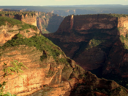
Geologically, the park is characterized by ancient Precambrian rock formations from the Chapada dos Guimarães Group, featuring red sandstone cliffs and plateaus formed through erosion over millions of years. The terrain is rugged, with steep escarpments, deep valleys, and canyons sculpted by water and wind, rising sharply from the surrounding plains. This "chapada" (plateau with cliffs) landscape is part of the broader Brazilian Central Plateau, with soils rich in iron oxides giving the rocks their distinctive reddish hue. The park protects a transition zone between the Cerrado savanna and Amazonian influences, with rivers and streams carving gorges and waterfalls. Erosion continues to shape features like natural arches and caves, while the plateau's elevation creates microclimates supporting diverse vegetation. Seismic activity is minimal, but the area is prone to seasonal flooding in valleys during heavy rains.
The park is a biodiversity hotspot within the Cerrado biome, one of the world's most diverse savannas, hosting a mix of open grasslands, gallery forests, and dry woodlands. Flora includes fire-adapted species like buriti palms (Mauritia flexuosa), pequi trees (Caryocar brasiliense), and various orchids, bromeliads, and cacti thriving on rocky outcrops. The vegetation mosaic supports endemic plants and serves as a seed bank for restoration efforts. Fauna is equally rich, with over 400 bird species, including scarlet macaws (Ara macao), greater rheas (Rhea americana), seriemas (Cariama cristata), and cliff-nesting swifts. Mammals include endangered species such as jaguars (Panthera onca), pumas (Puma concolor), maned wolves (Chrysocyon brachyurus), giant anteaters (Myrmecophaga tridactyla), tapirs (Tapirus terrestris), pampas deer (Ozotoceros bezoarticus), howler monkeys (Alouatta caraya), and armadillos. Reptiles like caimans and amphibians abound in wetlands, while insects and arachnids contribute to the ecosystem's complexity. This diversity arises from the park's ecotonal position, providing habitats for both Cerrado specialists and Pantanal migrants.
The park's landscapes are defined by towering red cliffs,
expansive plateaus, and verdant valleys, offering some of Brazil's
most photogenic scenery. Key features include:
Véu de Noiva
Waterfall: An 86-meter (282-foot) cascade plunging into a canyon,
accessible via a short trail; it's a highlight for its misty
veil-like appearance.
Cidade de Pedra (Stone City): Eroded
sandstone formations resembling ruins, with panoramic views from
clifftops.
Mirante da Geodésia: A viewpoint marking South
America's geographical center, with sweeping vistas of the plateau
and distant Pantanal.
Canyons and Caves: Deep gorges like the
Vale do Rio Claro, and caves with prehistoric paintings, such as
Casa de Pedra.
Waterfalls and Pools: Series like the Circuito das
Cachoeiras (Waterfall Circuit), including smaller falls and natural
swimming pools amid lush vegetation.
These elements create a
dramatic backdrop, with ancient rock art adding cultural depth. The
park's sunsets over the cliffs are particularly renowned, casting
golden hues on the red rocks.
As a core area of the Cerrado, the park plays a crucial role in protecting biodiversity hotspots under threat from agribusiness expansion, with deforestation in the biome rising 43% in 2023 compared to 2022. It safeguards river headwaters essential for the Pantanal's hydrology and serves as a buffer against climate change impacts. ICMBio oversees management, with efforts including fire prevention (addressing human-caused wildfires during dry seasons), habitat restoration, and wildlife monitoring. Challenges include invasive species, illegal logging, and tourism pressures. The park integrates with regional corridors for species migration. In 2023–2024, ICMBio advanced a 30-year concession for services like infrastructure maintenance and ecotourism operations, auctioned in February 2024, to enhance funding and visitor facilities while ensuring environmental safeguards.
As of August 2025, the park remains fully operational under ICMBio, with the 2024 concession likely implemented to improve visitor services amid ongoing Cerrado conservation concerns. No major boundary changes or closures have been reported, but increased focus on fire management follows recent regional droughts. Visitor numbers have rebounded post-pandemic, with emphasis on sustainable practices. The concession aims to revitalize infrastructure, such as trails and viewpoints, while monitoring biodiversity. External threats persist, including broader deforestation trends, but the park's integrity is maintained through partnerships and enforcement.
Chapada dos Guimarães draws ecotourists, hikers, and birdwatchers,
offering immersive experiences in Brazil's interior.
Top
Activities and Attractions:
Hiking trails like the 8-km Circuito das
Cachoeiras (moderate, 4–6 hours, featuring multiple waterfalls and pools
for swimming).
Birdwatching and wildlife spotting, especially at
dawn/dusk for maned wolves and macaws.
Viewpoint tours to Mirante and
Cidade de Pedra for photography and sunsets.
Cave explorations with
guides to see rock art (permit required).
Combined trips with nearby
Pantanal or Nobres for floating in crystal-clear rivers.
Practical Tips:
Best Time: Dry season (May–September) for accessible
trails and fewer insects; avoid peak wet months for flooding risks.
Access and Fees: Enter via main gate near Chapada town; entry fee around
R$20–30 (foreigners higher), plus guide fees (mandatory for some trails,
R$150–300/group). Open daily 8 AM–5 PM; book online via ICMBio.
Getting There: Fly to Cuiabá (CGB airport), then drive/bus 1–1.5 hours;
rent a car for flexibility.
Regulations: Stay on marked paths; no
drones, pets, or fires; hire accredited guides for safety (e.g., via
TripAdvisor-rated tours). Pack water, sunscreen, insect repellent,
sturdy shoes; respect wildlife distances.
Accommodations: Eco-lodges
like Pousada do Parque on the border, or hotels in Chapada town; book
ahead for holidays.
Nearby: Pair with Pantanal safaris (200 km south)
for a biodiversity contrast.
The park provides a profound escape
into nature, blending adventure with conservation awareness.